National Weather Service United States Department of Commerce

Severe Thunderstorms in the Central U.S.; Heavy Rainfall in the Southern Plains and the Carolinas

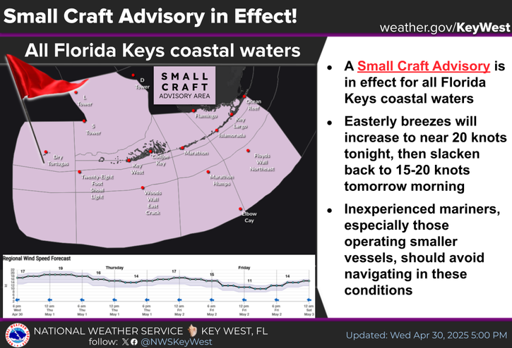
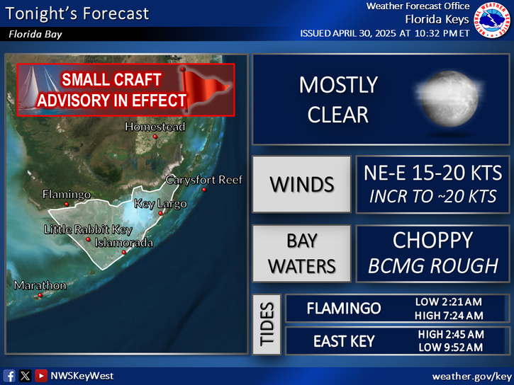
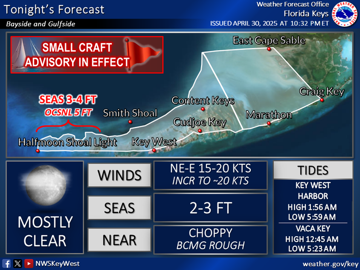
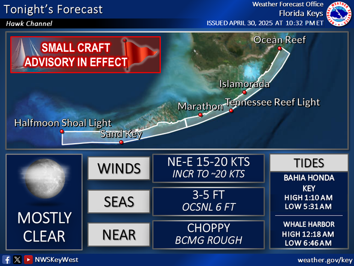
Scattered to numerous severe thunderstorms are expected to expand further east each day from the southern High Plains to the Tennessee and Lower Ohio Valleys to the Carolinas through Saturday. An area of low pressure in association with tropical moisture will produce periods of heavy rainfall for coastal portions of North Carolina today. Read More >

Click a location below for detailed forecast.

Last Map Update: Thu, Jun 5, 2025 at 3:20:15 pm EDT

The Florida Keys will remain under the influence of a Saharan Air Layer (SAL) through the weekend. What is the SAL?
  • An elevated layer of Saharan air and mineral dust that moves westward across the North Atlantic
  • Typically impacts the Florida Keys during the early summer months
  • Gives the sky a milky appearance during the day, typically limits rain chances, and often makes sunsets more vivid and picturesque
TODAY...Mostly cloudy, becoming partly sunny. Slight chance of showers and thunderstorms. Highs in the upper 80s. East to southeast winds near 15 mph. Chance of rain 10 percent.
TODAY...East to southeast winds near 15 knots. Bay waters a moderate chop. Isolated showers and thunderstorms.
SMALL CRAFT SHOULD EXERCISE CAUTION UNTIL WINDS DECREASE!
TODAY...East to southeast winds 15 to 20 knots, decreasing to near 15 knots in the afternoon. Seas 1 to 3 feet, subsiding to 1 to 2 feet. West of the Marquesas Keys, seas 3 to 4 feet, occasionally to 5 feet, subsiding to 2 to 3 feet. Nearshore waters choppy, becoming a moderate chop. Isolated showers and thunderstorms.
TODAY...East to southeast winds 15 to 20 knots, decreasing to near 15 knots late. Seas 3 to 4 feet, occasionally to 5 feet. Nearshore waters choppy, becoming a moderate chop. Isolated showers and thunderstorms.
SMALL CRAFT SHOULD EXERCISE CAUTION!
TODAY...East to southeast winds 15 to 20 knots. Seas 4 to 6 feet, occasionally to 8 feet. Wave Detail: East to southeast 5 feet at 6 seconds. Isolated showers and thunderstorms.
SMALL CRAFT SHOULD EXERCISE CAUTION UNTIL WINDS DECREASE!
TODAY...East to southeast winds 15 to 20 knots, decreasing to near 15 knots in the afternoon. Seas 3 to 4 feet, occasionally to 5 feet. Wave Detail: Southeast 4 feet at 5 seconds and southwest 1 foot at 6 seconds. Isolated showers and thunderstorms.


Text Product Selector
(Selected product opens in a new window) 


Sunrise & Sunset

Sunrise & Sunset


Moon Rise & Set

Moon Rise & Set


Moon Illumination

Moon Illumination


Tide Information

Tide Information


Tropical

Tropical


Coastal Flooding

Coastal Flooding


Tallship

Marine


Nearshore Waves

Wave Prediction


Thumbnail for a local waterspouts website, showing 4 waterspouts.

Waterspouts


Airplane

Aviation


Key West & Marathon Climographs 2020

Climographs


Tropical

Forecast Discussion


NOAA Weather Radio

NOAA Weather Radio