
Scattered thunderstorms with severe gusts, hail and a tornado risk are possible near a cold front from the Ohio Valley to the Mid-Atlantic tonight. Tropical Storm Bertha is expected to bring tropical storm conditions to portions of the Gulf Coast from the panhandle of Florida into Louisiana through Wednesday. Read More >
North Platte, NE
Weather Forecast Office
Overview
|
Tornado initially started as a land spout approximately 4 miles east of Dickens along Highway 23, before becoming a supercellular tornado. The tornado slowly tracked south for 3 miles over the next 45 minutes before dissipating 4 miles east-southeast of Dickens. |
Photos & Video
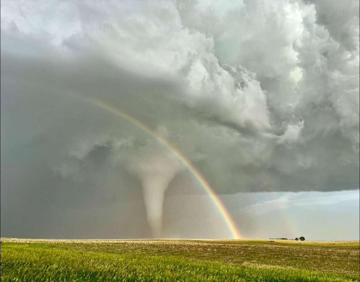
Photo Credit: Michael Charnick
Tornadoes
Select a tornado from the table to zoom into the track and view more information. The default table view is limited to 8 tracks, but can be scrolled by a mouse wheel or dynamically expanded. Additionally, the table can fill the entire window by clicking the small circular expanding arrow icon at the very top right of the table and returned to its original size by clicking the button again. The side information panel that opens over the map can be closed using the "X" on the upper right corner of the pop-up. Zoom into the map and click damage points to see detailed information and pictures from the surveys.
|
NOTE: times shown below are local to your device's time zone. |

The Enhanced Fujita (EF) Scale classifies tornadoes into the following categories:
| EF0 Weak 65-85 mph |
EF1 Moderate 86-110 mph |
EF2 Significant 111-135 mph |
EF3 Severe 136-165 mph |
EF4 Extreme 166-200 mph |
EF5 Catastrophic 200+ mph |
 |
|||||
| Tornadoes that fail to impact any ratable damage indicators on the EF-Scale are rated EF-Unknown (EF-U) | |||||
 |
Media use of NWS Web News Stories is encouraged! Please acknowledge the NWS as the source of any news information accessed from this site. |
|
HAZARDS
Active Alerts
National Radar
National Hurricane Center
Storm Prediction Center
Weather Prediction Center
River Flooding
Decision Support
Submit a Storm Report
Recent Storm Reports
CURRENT CONDITIONS
CoCoRaHS
Enhanced Data Display
Local Radar
National Radar Mosiac
Observations
National Snow Cover
Precipitation Mapped
Regional Links
Satellite
Snowfall Analysis
FORECASTS
Area Forecast Discussion
Aviation Weather Center
Local Aviation Weather
Fire Weather
Recreation Forecast
National Graphical Forecast
Local Graphical Forecast
CLIMATE
Local Climate
National Climate
North Platte - Daily
North Platte - Monthly
Valentine - Daily
Valentine - Monthly
Broken Bow - Daily
Broken Bow - Monthly
Imperial - Daily
Imperial - Monthly
NIDIS Drought
NOAA Climate Science
Local Storm Reports
Local Drought Statement
US Dept of Commerce
National Oceanic and Atmospheric Administration
National Weather Service
North Platte, NE
5250 E. Lee Bird Drive
North Platte, NE 69101-2473
308-532-4936
Comments? Questions? Please Contact Us.

