 |
 |
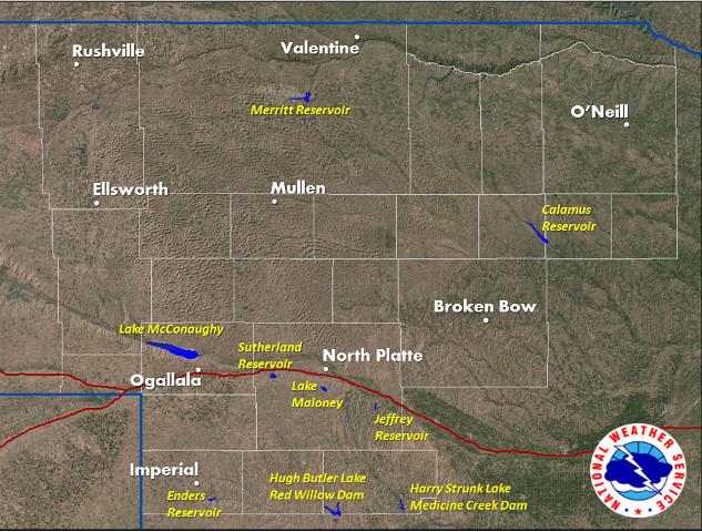
Recreation Forecasts available for:
- Lake McConaughy
- Calamus Reservoir
- Sutherland Reservoir
- Lake Maloney
- Enders Reservoir
- Merritt Reservoir
- Red Willow Reservoir
- Medicine Creek Reservoir
- Jeffrey Reservoir
|
Current Lake Forecasts in Western and North Central Nebraska
735
SXUS43 KLBF 270042
RECLBF
Recreational Forecast
National Weather Service North Platte NE
741 PM CDT Sun Apr 26 2026
NEZ057-270900-
Lake McConaughy-
741 PM CDT Sun Apr 26 2026
...THE FORECAST FOR LAKE MCCONAUGHY...
...CAUTION IS ADVISED FOR WIND AND WAVES MONDAY...
.TONIGHT...East winds 4 to 10 mph increasing to north 8 to 14 mph
after midnight. Cloudy. Patchy fog. A chance of showers. The
chance of precipitation 60 percent. Lows around 38. Waters a
light chop becoming a moderate chop after midnight.
.MONDAY...Northwest winds 14 to 24 mph shifting to the north
18 to 24 mph in the afternoon. Mostly cloudy in the morning then
becoming mostly sunny. Patchy fog in the morning. A chance of
showers in the morning, then a slight chance of showers in the
afternoon. The chance of precipitation 40 percent. Highs around
50. Waters rough.
.MONDAY NIGHT...Northeast winds 10 to 16 mph becoming east 4 to
6 mph after midnight. Mostly cloudy. A chance of showers in the
evening, then showers likely after midnight. The chance of
precipitation 70 percent. Lows around 33. Waters a moderate chop
becoming smooth to a light chop after midnight.
.TUESDAY...Southeast winds 4 to 10 mph. Showers and a slight
chance of snow showers in the morning, then showers likely in the
afternoon. The chance of precipitation 90 percent. Highs around
50. Waters a light chop.
$$
NEZ027-038-270900-
Calamus Reservoir-
741 PM CDT Sun Apr 26 2026
...THE FORECAST FOR CALAMUS RESERVOIR...
...EXTREME CAUTION IS ADVISED FOR WIND AND WAVES MONDAY AND
CAUTION IS ADVISED FOR WIND AND WAVES MONDAY NIGHT...
.TONIGHT...Northeast winds 4 to 6 mph increasing to north 8 to
14 mph after midnight. Cloudy. Patchy fog. A chance of showers
and a slight chance of thunderstorms. The chance of precipitation
60 percent. Lows around 39. Waters smooth to a light chop
becoming a moderate chop after midnight.
.MONDAY...Windy. Northwest winds 18 to 28 mph increasing to 26 to
30 mph with gusts to near 45 mph in the afternoon. Cloudy. Patchy
fog. A chance of showers. The chance of precipitation 40 percent.
Highs around 48. Waters very rough.
.MONDAY NIGHT...Northwest winds 14 to 24 mph becoming north 4 to
8 mph after midnight. Mostly cloudy. A chance of showers after
midnight. The chance of precipitation 30 percent. Lows around 31.
Waters rough becoming smooth to a light chop after midnight.
.TUESDAY...Northeast winds 4 to 6 mph. Mostly cloudy. Showers
likely in the morning, then a chance of showers in the afternoon.
The chance of precipitation 60 percent. Highs around 47. Waters
smooth to a light chop.
$$
XXZ059-270900-
Sutherland Reservoir-
741 PM CDT Sun Apr 26 2026
...THE FORECAST FOR SUTHERLAND RESERVOIR...
...CAUTION IS ADVISED FOR WIND AND WAVES MONDAY...
.TONIGHT...Northeast winds 4 to 10 mph increasing to north 8 to
14 mph after midnight. Cloudy. Patchy fog. Showers likely and a
slight chance of thunderstorms in the evening. A chance of
showers after midnight. The chance of precipitation 60 percent.
Lows around 37. Waters a light chop becoming a moderate chop
after midnight.
.MONDAY...Northwest winds 14 to 22 mph increasing to north 20 to
24 mph in the afternoon. Mostly cloudy in the morning then
becoming mostly sunny. Patchy fog in the morning. A chance of
showers in the morning. The chance of precipitation 40 percent.
Highs around 54. Waters choppy becoming rough in the afternoon.
.MONDAY NIGHT...North winds 8 to 18 mph becoming northeast 4 to
8 mph after midnight. Mostly cloudy. A slight chance of showers
in the evening, then showers likely after midnight. The chance of
precipitation 70 percent. Lows around 32. Waters choppy becoming
smooth to a light chop after midnight.
.TUESDAY...East winds 4 to 8 mph increasing to 8 to 10 mph in the
afternoon. Mostly cloudy. Showers in the morning, then a chance
of showers in the afternoon. The chance of precipitation
80 percent. Highs around 52. Waters smooth to a light chop
becoming a light chop in the afternoon.
$$
XXZ059-270900-
Lake Maloney-
741 PM CDT Sun Apr 26 2026
...THE FORECAST FOR LAKE MALONEY...
...CAUTION IS ADVISED FOR WIND AND WAVES MONDAY...
.TONIGHT...Northeast winds 4 to 10 mph increasing to north 10 to
14 mph after midnight. Mostly cloudy. Patchy fog in the evening,
then areas of fog after midnight. Showers likely and a slight
chance of thunderstorms in the evening, then a chance of showers
after midnight. The chance of precipitation 60 percent. Lows
around 37. Waters a light chop becoming a moderate chop after
midnight.
.MONDAY...Northwest winds 14 to 22 mph increasing to 20 to 24 mph
in the afternoon. Gusts up to 35 mph. Mostly cloudy in the
morning then becoming mostly sunny. Patchy fog in the morning. A
chance of showers in the morning. The chance of precipitation
40 percent. Highs around 53. Waters choppy becoming rough in the
afternoon.
.MONDAY NIGHT...North winds 10 to 18 mph becoming northeast 6 to
10 mph after midnight. Mostly cloudy. A slight chance of showers
in the evening, then showers likely after midnight. The chance of
precipitation 60 percent. Lows around 32. Waters choppy becoming
a light chop after midnight.
.TUESDAY...East winds 6 to 8 mph. Mostly cloudy. Showers in the
morning, then a chance of showers in the afternoon. The chance of
precipitation 80 percent. Highs around 52. Waters smooth to a
light chop.
$$
XXZ069-270900-
Enders Reservoir-
741 PM CDT Sun Apr 26 2026
...THE FORECAST FOR ENDERS RESERVOIR...
...CAUTION IS ADVISED FOR WIND AND WAVES MONDAY...
.TONIGHT...North winds 6 to 12 mph. Mostly cloudy. Patchy fog.
Showers likely and a chance of thunderstorms in the evening. A
chance of showers and a slight chance of thunderstorms after
midnight. The chance of precipitation 60 percent. Lows around 37.
Waters a light chop.
.MONDAY...Northwest winds 12 to 22 mph shifting to the north
16 to 22 mph in the afternoon. Gusts up to 30 mph. Mostly cloudy
in the morning then clearing. Patchy fog in the morning. A chance
of showers in the morning. The chance of precipitation
30 percent. Highs around 58. Waters choppy.
.MONDAY NIGHT...Northeast winds 10 to 14 mph decreasing to 4 to
10 mph after midnight. Mostly cloudy. A chance of showers in the
evening, then showers and a slight chance of thunderstorms after
midnight. The chance of precipitation 80 percent. Lows around 32.
Waters a moderate chop becoming a light chop after midnight.
.TUESDAY...Southeast winds 4 to 8 mph. Cloudy in the morning then
becoming partly sunny. Showers likely in the morning, then a
chance of showers in the afternoon. The chance of precipitation
70 percent. Highs around 58. Waters smooth to a light chop.
$$
NEZ094-005-024-270900-
Merritt Reservoir-
741 PM CDT Sun Apr 26 2026
...THE FORECAST FOR MERRITT RESERVOIR...
...EXTREME CAUTION IS ADVISED FOR WIND AND WAVES MONDAY...
.TONIGHT...Northeast winds 6 to 8 mph increasing to north 8 to
14 mph after midnight. Cloudy. Areas of fog. A chance of showers
in the evening. Showers likely after midnight. The chance of
precipitation 70 percent. Lows around 34. Waters smooth to a
light chop becoming a moderate chop after midnight.
.MONDAY...Breezy. Northwest winds 14 to 24 mph increasing to
22 to 26 mph in the afternoon. Gusts up to 35 mph. Cloudy. Patchy
fog in the morning. Showers likely in the morning, then a chance
of showers in the afternoon. The chance of precipitation
70 percent. Highs around 47. Waters rough.
.MONDAY NIGHT...North winds 12 to 18 mph becoming northwest 4 to
6 mph after midnight. Mostly cloudy. A slight chance of showers
after midnight. The chance of precipitation 30 percent. Lows
around 30. Waters choppy becoming smooth to a light chop after
midnight.
.TUESDAY...Southeast winds 4 to 6 mph increasing to 6 to 10 mph
in the afternoon. Showers likely in the morning, then showers in
the afternoon. The chance of precipitation 80 percent. Highs
around 47. Waters smooth to a light chop becoming a light chop in
the afternoon.
$$
XXZ071-270900-
Red Willow Reservoir-
741 PM CDT Sun Apr 26 2026
...THE FORECAST FOR RED WILLOW RESERVOIR...
...EXTREME CAUTION IS ADVISED FOR WIND AND WAVES MONDAY...
.TONIGHT...Northeast winds 6 to 10 mph shifting to the north 8 to
14 mph after midnight. Mostly cloudy. Patchy fog. A chance of
thunderstorms. The chance of precipitation 60 percent. Lows
around 38. Waters a light chop becoming a moderate chop after
midnight.
.MONDAY...Breezy. Northwest winds 14 to 24 mph increasing to
20 to 26 mph in the afternoon. Gusts up to 35 mph. Partly sunny.
Patchy fog in the morning. A chance of showers in the morning.
The chance of precipitation 40 percent. Highs around 58. Waters
rough.
.MONDAY NIGHT...North winds 10 to 18 mph becoming northeast 4 to
10 mph after midnight. Partly cloudy in the evening then becoming
mostly cloudy. A slight chance of showers in the evening, then
showers likely after midnight. The chance of precipitation
70 percent. Lows around 33. Waters choppy becoming a light chop
after midnight.
.TUESDAY...East winds 4 to 8 mph increasing to 8 to 10 mph in the
afternoon. Mostly cloudy. Showers likely in the morning, then a
chance of showers in the afternoon. The chance of precipitation
60 percent. Highs around 56. Waters smooth to a light chop
becoming a light chop in the afternoon.
$$
XXZ071-270900-
Medicine Creek Reservoir-
741 PM CDT Sun Apr 26 2026
...THE FORECAST FOR MEDICINE CREEK RESERVOIR...
...CAUTION IS ADVISED FOR WIND AND WAVES MONDAY...
.TONIGHT...Northeast winds 6 to 10 mph shifting to the north 8 to
14 mph after midnight. Mostly cloudy. Patchy fog. Showers likely
and a chance of thunderstorms. The chance of precipitation
60 percent. Lows around 39. Waters a light chop becoming a
moderate chop after midnight.
.MONDAY...Northwest winds 14 to 24 mph increasing to 20 to 24 mph
in the afternoon. Partly sunny. Patchy fog in the morning. A
chance of showers in the morning. The chance of precipitation
40 percent. Highs around 58. Waters rough.
.MONDAY NIGHT...North winds 10 to 18 mph decreasing to 4 to
10 mph after midnight. Partly cloudy in the evening then becoming
mostly cloudy. A slight chance of showers in the evening, then
showers likely after midnight. The chance of precipitation
60 percent. Lows around 33. Waters choppy becoming a light chop
after midnight.
.TUESDAY...Northeast winds 4 to 8 mph. Mostly cloudy. Showers
likely in the morning, then a chance of showers in the afternoon.
The chance of precipitation 60 percent. Highs around 56. Waters
smooth to a light chop.
$$
XXZ059-270900-
Jeffrey Reservoir-
741 PM CDT Sun Apr 26 2026
...THE FORECAST FOR JEFFREY RESERVOIR...
...CAUTION IS ADVISED FOR WIND AND WAVES MONDAY...
.TONIGHT...Northeast winds 6 to 10 mph shifting to the north 8 to
14 mph after midnight. Mostly cloudy. Patchy fog. A chance of
thunderstorms in the evening. Showers likely. A slight chance of
thunderstorms after midnight. The chance of precipitation
60 percent. Lows around 37. Waters a light chop becoming a
moderate chop after midnight.
.MONDAY...Northwest winds 14 to 22 mph increasing to 20 to 22 mph
in the afternoon. Gusts up to 30 mph. Partly sunny. Patchy fog in
the morning. A chance of showers in the morning. The chance of
precipitation 40 percent. Highs around 54. Waters choppy.
.MONDAY NIGHT...North winds 8 to 18 mph decreasing to 4 to 10 mph
after midnight. Mostly cloudy. Showers likely after midnight. The
chance of precipitation 60 percent. Lows around 32. Waters choppy
becoming a light chop after midnight.
.TUESDAY...East winds 4 to 6 mph. Mostly cloudy. Showers likely
in the morning, then a chance of showers in the afternoon. The
chance of precipitation 70 percent. Highs around 52. Waters
smooth to a light chop.
$$
&&
Note: Wind and wave action are for ice free areas in winter.