
Dangerous heat will expand from the Gulf Coast into the Southern Plains and Desert Southwest through week's end. Additional extreme heat impacting the Pacific Northwest will shift to the northern Plains by the weekend. Tropical Storm Bertha is expected to continue to impact portions of the northern Gulf Coast from the western Florida Panhandle to southeastern Louisiana through tonight. Read More >
Overview
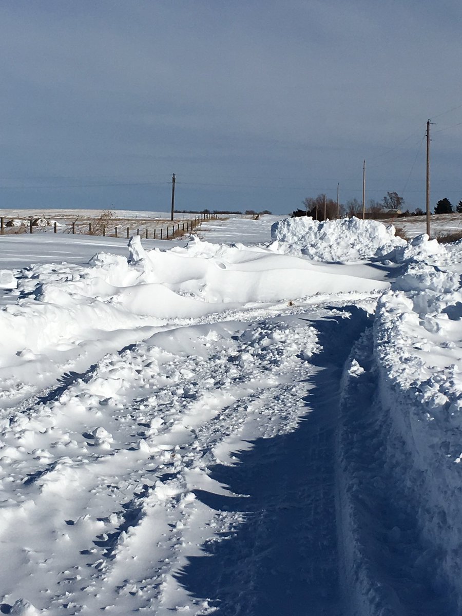
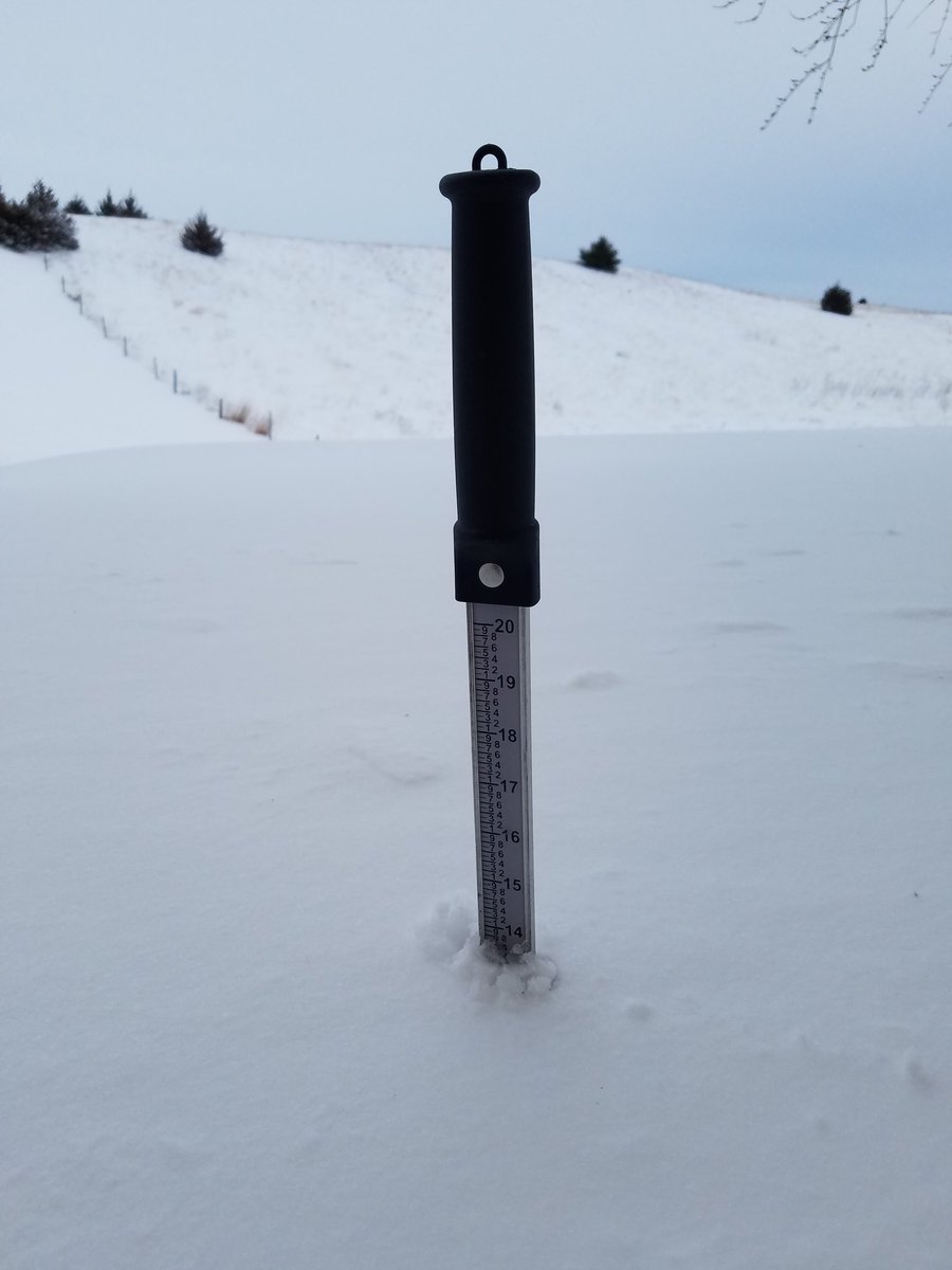
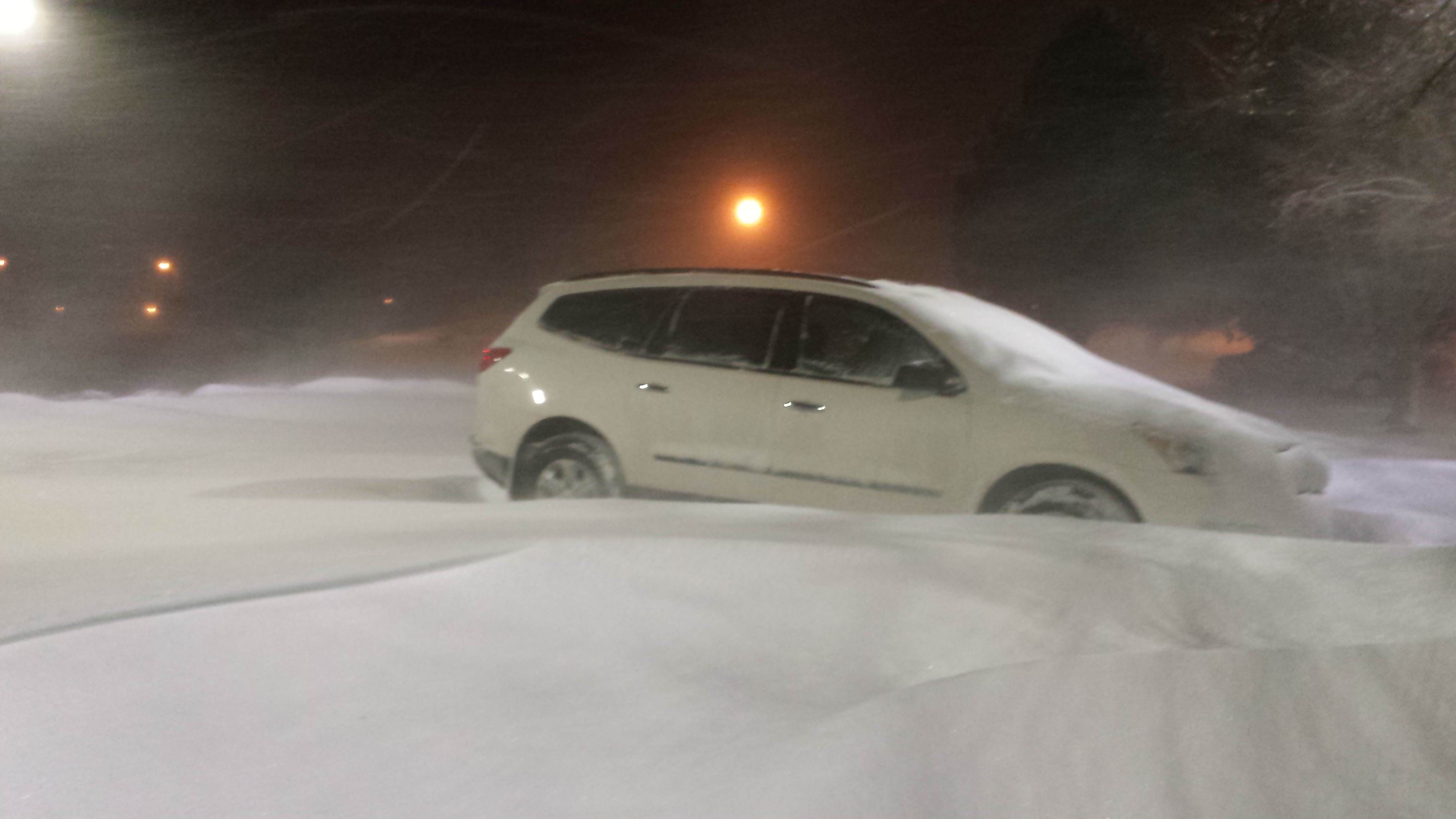
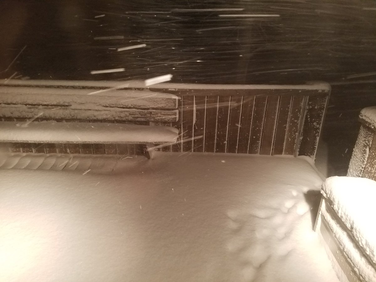
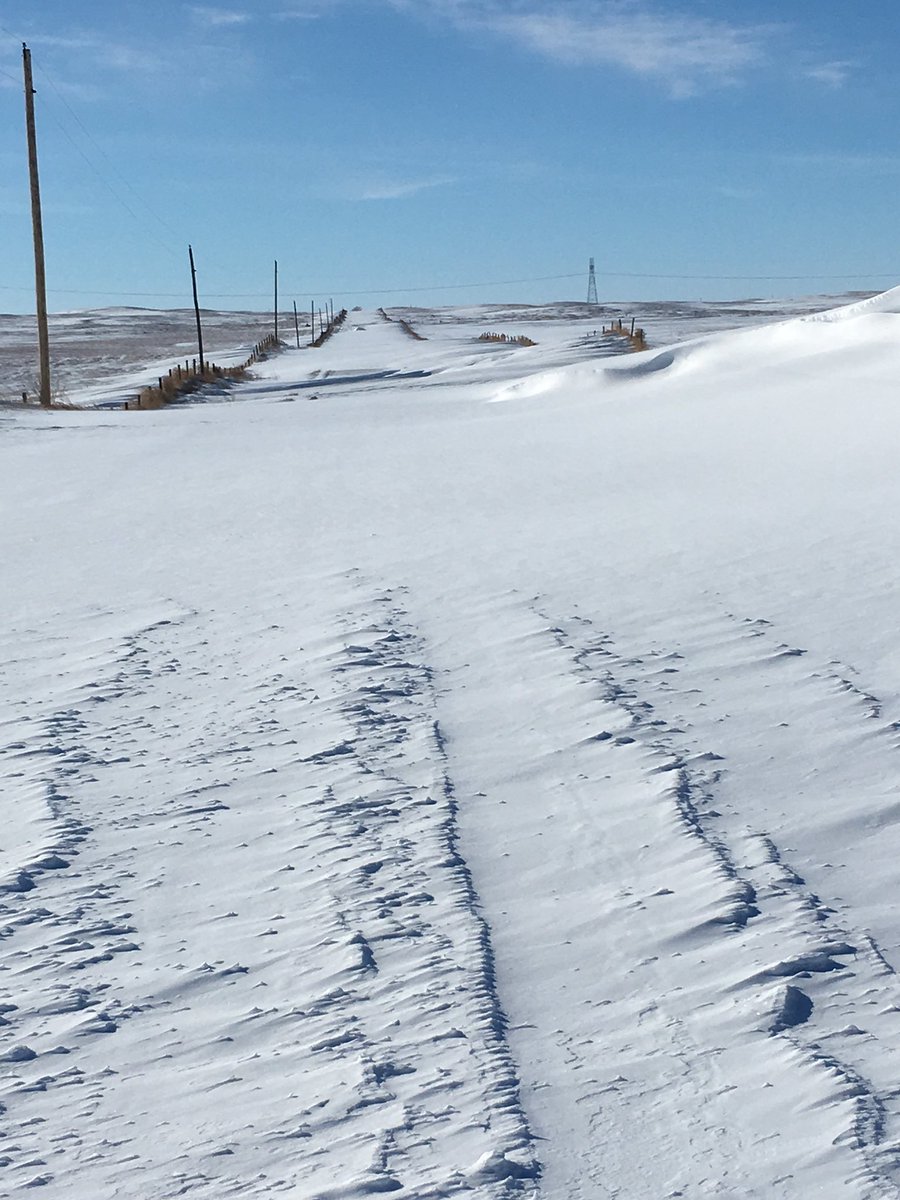
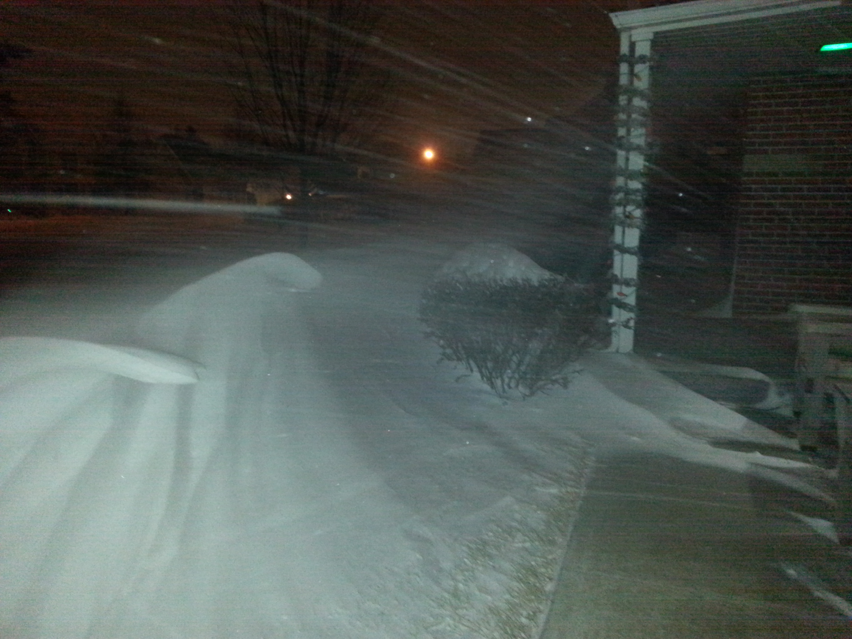
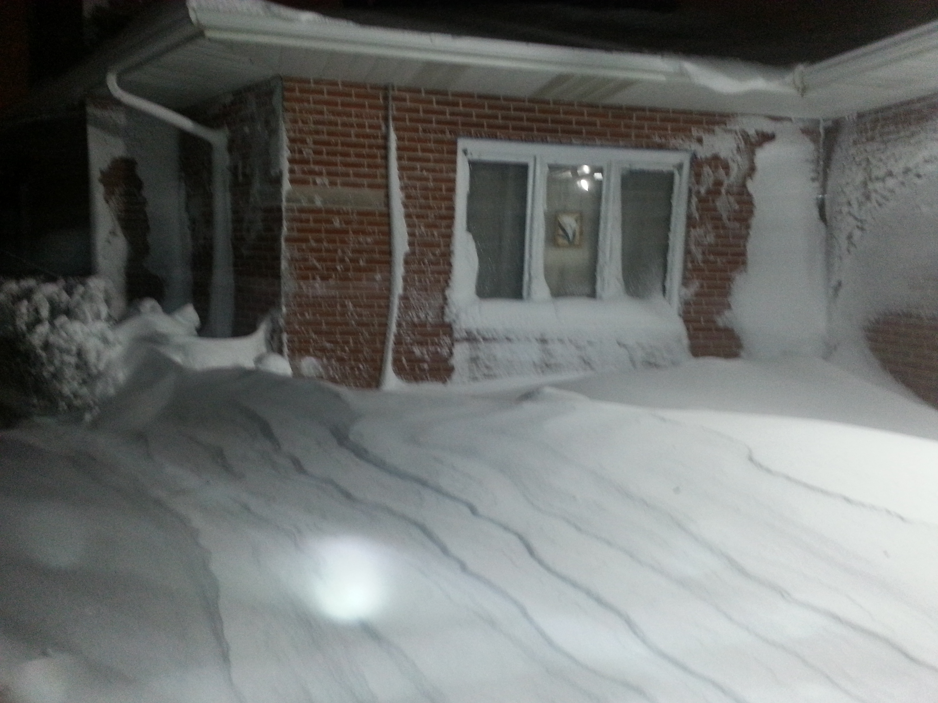
Snow began initially across the northwest Sandhills during the early morning hours Sunday, and continued through around noon Sunday. That area of snow began to diminish early afternoon, as a new area developed across southwest into central Nebraska mid to late afternoon. Sunday night into Monday, this became a strong and mature system, dropping a wide swath of heavy snow ranging from 8 to 12 inches. Combined with northwest winds of 20 to 35 mph, with gusts to 45 mph, significant blowing and drifting occurred. Snow drifts up to 3 to 5 feet were reported. Some roads became closed, especially county roads.Photos:
 |
 |
 |
 |
| south of North Platte (photo by John Stoppkotte) |
north of North Platte (photo by Kelly Allen) |
NWS North Platte |
north of North Platte (photo by Kelly Allen) |
 |
 |
 |
|
| south of North Platte (photo by John Stoppkotte) |
North Platte (photo by Teresa Keck) |
North Platte (photo by Teresa Keck) |
Radar:
Radar loop from midnight Sunday to noon Monday CST
Pink outline: Winter Storm Warning ; Red outline: Blizzard Warning
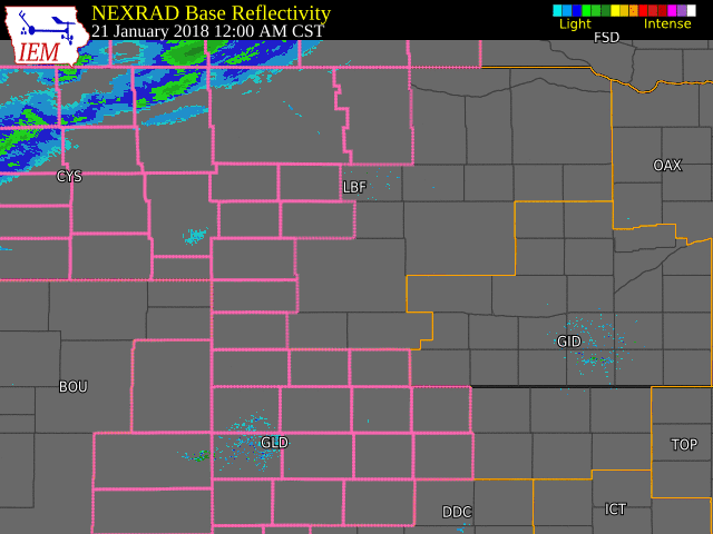
radar archive courtesy of the Iowa Environmental Mesonet
Storm Reports
.png)
Map compiled from storm reports (public, cooperative observer, and official NWS observations) and radar estimates
List of snow and wind reports:
..TIME...   ...EVENT...      ...CITY LOCATION...     ...LAT.LON...
..DATE...   ....MAG....      ..COUNTY LOCATION..ST.. ...SOURCE....
            ..REMARKS..

0105 PM     SNOW             LEWELLEN                41.33N 102.14W
01/21/2018  E3.5 INCH        GARDEN             NE   PUBLIC

0105 PM     HEAVY SNOW       GRANT                   40.84N 101.73W
01/21/2018  E6.0 INCH        PERKINS            NE   PUBLIC

0105 PM     SNOW             5 W STAPLETON           41.48N 100.61W
01/21/2018  M5.0 INCH        LOGAN              NE   CO-OP OBSERVER

0105 PM     SNOW             8 WSW CALLAWAY          41.25N 100.06W
01/21/2018  M5.1 INCH        CUSTER             NE   CO-OP OBSERVER

            STILL SNOWING PRETTY GOOD

0105 PM     HEAVY SNOW       N ELLSWORTH             42.06N 102.29W
01/21/2018  E6.0 INCH        SHERIDAN           NE   PUBLIC

0105 PM     HEAVY SNOW       IMPERIAL                40.52N 101.64W
01/21/2018  M6.5 INCH        CHASE              NE   CO-OP OBSERVER

            STILL SNOWING PRETTY GOOD. 1/2 MILE VISIBILITY

0118 PM     SNOW             4 W BIG SPRINGS         41.06N 102.15W
01/21/2018  M4.0 INCH        DEUEL              NE   CO-OP OBSERVER

0118 PM     SNOW             4 W BIG SPRINGS         41.06N 102.15W
01/21/2018  M4.0 INCH        DEUEL              NE   CO-OP OBSERVER

0118 PM     SNOW             10 NE OSHKOSH           41.51N 102.21W
01/21/2018  M1.0 INCH        GARDEN             NE   CO-OP OBSERVER

0118 PM     SNOW             4 W BIG SPRINGS         41.06N 102.15W
01/21/2018  M4.0 INCH        DEUEL              NE   CO-OP OBSERVER

0524 PM     SNOW             10 NE OSHKOSH           41.51N 102.21W
01/21/2018  M3.0 INCH        GARDEN             NE   CO-OP OBSERVER

            VISIBILITY 3/8 TO 1/2 OF A MILE AT TIME OF THE REPORT.

0524 PM     SNOW             2 E NORTH PLATTE        41.13N 100.73W
01/21/2018  M1.6 INCH        LINCOLN            NE   OFFICIAL NWS OBS

            SNOW TOTAL SO FAR. VISIBILITY OF 1/2 MILE.

0715 PM     SNOW             8 SW GRANT              40.76N 101.83W
01/21/2018  E5.0 INCH        PERKINS            NE   PUBLIC

0715 PM     SNOW             4 W BIG SPRINGS         41.06N 102.15W
01/21/2018  M4.0 INCH        DEUEL              NE   CO-OP OBSERVER

0758 PM     SNOW             3 ENE NORTH PLATTE      41.15N 100.72W
01/21/2018  M4.0 INCH        LINCOLN            NE   OFFICIAL NWS OBS

            STORM TOTAL AS OF 8 PM CST. STILL SNOWING WITH 1/2 MI.
            VISBY

0848 PM     NON-TSTM WND GST 1 NW BROKEN BOW         41.42N 99.65W
01/21/2018  M46.00 MPH       CUSTER             NE   ASOS

0911 PM     HEAVY SNOW       4 NE NORTH PLATTE       41.17N 100.72W
01/21/2018  M6.0 INCH        LINCOLN            NE   NWS EMPLOYEE

0911 PM     SNOW             2 E NORTH PLATTE        41.13N 100.73W
01/21/2018  M5.0 INCH        LINCOLN            NE   OFFICIAL NWS OBS

            TOTAL SNOWFALL AS OF 9 PM CST. STILL SNOWING WITH 1/2
            MILE OF VISIBILITY.

0915 PM     HEAVY SNOW       NORTH PLATTE            41.13N 100.77W
01/21/2018  E6.0 INCH        LINCOLN            NE   BROADCAST MEDIA

0943 PM     NON-TSTM WND GST 4 NW BIG SPRINGS        41.10N 102.13W
01/21/2018  M43.00 MPH       DEUEL              NE   DEPT OF HIGHWAYS

1015 PM     SNOW             3 NE NORTH PLATTE       41.16N 100.73W
01/21/2018  E6.5 INCH        LINCOLN            NE   PUBLIC

1025 PM     SNOW             THEDFORD                41.98N 100.57W
01/21/2018  M5.0 INCH        THOMAS             NE   PUBLIC

1034 PM     BLIZZARD         1 W MERNA               41.48N 99.78W
01/21/2018                   CUSTER             NE   LAW ENFORCEMENT

            SHERIFF DEPUTY REPORTS NEAR ZERO VISIBILITY ONE MILE WEST
            OF MERNA.

1040 PM     NON-TSTM WND GST 6 NW DUNNING            41.89N 100.19W
01/21/2018  M44.00 MPH       BLAINE             NE   MESONET

1100 PM     HEAVY SNOW       5 N NORTH PLATTE        41.21N 100.77W
01/21/2018  M8.5 INCH        LINCOLN            NE   NWS EMPLOYEE

1115 PM     HEAVY SNOW       1 E NORTH PLATTE        41.13N 100.75W
01/21/2018  M7.0 INCH        LINCOLN            NE   NWS EMPLOYEE

1200 AM     HEAVY SNOW       3 ENE NORTH PLATTE      41.15N 100.72W
01/22/2018  M8.0 INCH        LINCOLN            NE   OFFICIAL NWS OBS

            24 HOUR TOTAL AND PRELIM STORM TOTAL. STILL SNOWING
            MODERATELY WITH 1/2 MI VISBY

1202 AM     NON-TSTM WND GST 1 NW BROKEN BOW         41.42N 99.65W
01/22/2018  M49.00 MPH       CUSTER             NE   ASOS

1215 AM     NON-TSTM WND GST 7 NW AINSWORTH          42.62N 99.95W
01/22/2018  M40.00 MPH       BROWN              NE   AWOS

0100 AM     NON-TSTM WND GST 8 WNW ROSE              42.21N 99.67W
01/22/2018  M44.00 MPH       BROWN              NE   MESONET

0152 AM     NON-TSTM WND GST 1 N IMPERIAL            40.53N 101.64W
01/22/2018  M47.00 MPH       CHASE              NE   ASOS

0223 AM     NON-TSTM WND GST 2 W HALSEY              41.90N 100.31W
01/22/2018  M42.00 MPH       THOMAS             NE   PARK/FOREST SRVC

0300 AM     HEAVY SNOW       3 ENE NORTH PLATTE      41.15N 100.72W
01/22/2018  M10.3 INCH       LINCOLN            NE   OFFICIAL NWS OBS

            STORM TOTAL AS OF 3 AM CST. DRIFTS TO 3 FT. SNOW LETTING
            UP, VISBY OVER 1 MI.

0305 AM     HEAVY SNOW       LONG PINE               42.53N 99.70W
01/22/2018  E12.0 INCH       BROWN              NE   PUBLIC

0335 AM     NON-TSTM WND GST 4 E NORTH PLATTE        41.13N 100.69W
01/22/2018  M39.00 MPH       LINCOLN            NE   ASOS

0415 AM     NON-TSTM WND GST 3 N HAYES CENTER        40.55N 101.02W
01/22/2018  M45.00 MPH       HAYES              NE   MESONET

0500 AM     HEAVY SNOW       VALENTINE               42.87N 100.55W
01/22/2018  M6.1 INCH        CHERRY             NE   COCORAHS

            SWE 0.35 IN.

0515 AM     NON-TSTM WND GST 2 NW ONEILL             42.48N 98.67W
01/22/2018  M41.00 MPH       HOLT               NE   AWOS

0600 AM     SNOW             5 SSE HERSHEY           41.09N 100.96W
01/22/2018  M7.0 INCH        LINCOLN            NE   CO-OP OBSERVER

0600 AM     SNOW             1 S VALENTINE           42.86N 100.55W
01/22/2018  M3.5 INCH        CHERRY             NE   OFFICIAL NWS OBS

            24 HOUR TOTAL

0600 AM     SNOW             3 ENE NORTH PLATTE      41.15N 100.72W
01/22/2018  M11.4 INCH       LINCOLN            NE   OFFICIAL NWS OBS

            24 HOUR TOTAL

0600 AM     SNOW             1 W VALENTINE           42.87N 100.57W
01/22/2018  M6.1 INCH        CHERRY             NE   COCORAHS

            24 HOUR TOTAL

0658 AM     BLIZZARD         WELLFLEET               40.75N 100.73W
01/22/2018                   LINCOLN            NE   COUNTY OFFICIAL

            NEDOR HAS CLOSED HIGHWAY 83 BETWEEN NEBRASKA 23 AND OPAL
            ROAD.

0700 AM     SNOW             1 NW HAYES CENTER       40.52N 101.03W
01/22/2018  E8.0 INCH        HAYES              NE   CO-OP OBSERVER

            24 HOUR TOTAL

0700 AM     SNOW             ESE ANSLEY              41.29N 99.38W
01/22/2018  M8.5 INCH        CUSTER             NE   COCORAHS

            24 HOUR TOTAL

0700 AM     SNOW             8 SW MADRID             40.77N 101.65W
01/22/2018  M11.6 INCH       PERKINS            NE   COCORAHS

            24 HOUR TOTAL

0700 AM     SNOW             9 ENE CHAPPELL          41.14N 102.31W
01/22/2018  M9.0 INCH        DEUEL              NE   COCORAHS

            24 HOUR TOTAL

0700 AM     SNOW             5 W STAPLETON           41.48N 100.61W
01/22/2018  M10.0 INCH       LOGAN              NE   CO-OP OBSERVER

0700 AM     SNOW             MADRID                  40.85N 101.54W
01/22/2018  E11.2 INCH       PERKINS            NE   CO-OP OBSERVER

0700 AM     SNOW             2 SSW BURWELL           41.75N 99.15W
01/22/2018  M6.0 INCH        GARFIELD           NE   COCORAHS

            24 HOUR TOTAL

0700 AM     SNOW             1 W NORTH PLATTE        41.13N 100.79W
01/22/2018  M10.5 INCH       LINCOLN            NE   COCORAHS

            24 HOUR TOTAL

0700 AM     SNOW             3 S LAMAR               40.53N 101.98W
01/22/2018  M6.0 INCH        CHASE              NE   COCORAHS

            24 HOUR TOTAL

0700 AM     SNOW             S ARTHUR                41.57N 101.69W
01/22/2018  M5.0 INCH        ARTHUR             NE   COCORAHS

            24 HOUR TOTAL

0700 AM     SNOW             11 ENE TRYON            41.62N 100.75W
01/22/2018  M8.0 INCH        MCPHERSON          NE   COCORAHS

            24 HOUR TOTAL

0700 AM     SNOW             9 NW ANSELMO            41.71N 99.99W
01/22/2018  M9.0 INCH        CUSTER             NE   COCORAHS

            24 HOUR TOTAL

0726 AM     SNOW             8 SW GRANT              40.76N 101.83W
01/22/2018  M13.0 INCH       PERKINS            NE   PUBLIC

            24 HOUR TOTAL REPORTED ON FACEBOOK

0730 AM     SNOW             2 SE ANSELMO            41.60N 99.84W
01/22/2018  E10.0 INCH       CUSTER             NE   CO-OP OBSERVER

            24 HOUR TOTAL, 1.25 LIQUID PRECIPITATION

0745 AM     SNOW             10 S ARNOLD             41.28N 100.19W
01/22/2018  M10.0 INCH       CUSTER             NE   COCORAHS

            24 HOUR TOTAL

0758 AM     SNOW             BRADY                   41.02N 100.37W
01/22/2018  M8.3 INCH        LINCOLN            NE   CO-OP OBSERVER

            24 HOUR TOTAL

0800 AM     SNOW             2 S MULLEN              42.01N 101.04W
01/22/2018  M4.5 INCH        HOOKER             NE   COCORAHS

            24 HOUR TOTAL

0800 AM     SNOW             NEWPORT                 42.60N 99.33W
01/22/2018  M4.0 INCH        ROCK               NE   CO-OP OBSERVER

0900 AM     SNOW             16 SW MULLEN            41.88N 101.26W
01/22/2018  E7.5 INCH        HOOKER             NE   PUBLIC

            24 HOUR TOTAL REPORTED ON SOCIAL MEDIA, 2 TO 3 FOOT
            DRIFTS

0945 AM     SNOW             1 W NORTH PLATTE        41.13N 100.79W
01/22/2018  M8.2 INCH        LINCOLN            NE   NWS EMPLOYEE

            24 HOUR TOTAL

0951 AM     SNOW             10 NE OSHKOSH           41.51N 102.21W
01/22/2018  M3.5 INCH        GARDEN             NE   CO-OP OBSERVER

            24 HOUR TOTAL, 0.24 INCHES OF PRECIPITATION

1000 AM     SNOW             ARTHUR                  41.57N 101.69W
01/22/2018  M5.0 INCH        ARTHUR             NE   PUBLIC

            SNOWFALL OF 5.0 INCHES OF SNOWFALL AND 0.30 INCHES OF
            LIQUID PRECIPITATION.

1004 AM     SNOW             ELSIE                   40.85N 101.39W
01/22/2018  E8.0 INCH        PERKINS            NE   PUBLIC

            24 HOUR TOTAL REPORTED ON SOCIAL MEDIA

1009 AM     SNOW             3 SW ATKINSON           42.50N 99.02W
01/22/2018  E5.0 INCH        HOLT               NE   CO-OP OBSERVER

            24 HOUR TOTAL, 0.55 INCHES LIQUID PRECIPITATION

1009 AM     SNOW             4 N VALENTINE           42.93N 100.55W
01/22/2018  M6.5 INCH        CHERRY             NE   PUBLIC

            24 HOUR TOTAL, 0.52 INCHES LIQUID PRECIPITATION

1032 AM     SNOW             10 NW ANSELMO           41.72N 100.00W
01/22/2018  M9.0 INCH        CUSTER             NE   PUBLIC

            24 HOUR TOTAL REPORTED ON SOCIAL MEDIA, 0.95 INCHES
            LIQUID PRECIPITATION

1100 AM     SNOW             BASSETT                 42.58N 99.54W
01/22/2018  M6.8 INCH        ROCK               NE   CO-OP OBSERVER

            6.8 INCHES OF SNOWFALL WITH 0.44 INCHES OF LIQUID
            PRECIPITATION.

1100 AM     SNOW             5 W MERNA               41.48N 99.86W
01/22/2018  E10.0 INCH       CUSTER             NE   PUBLIC

            SNOWFALL REPORT VIA SOCIAL MEDIA.
1200 PM     HEAVY SNOW       8 WNW NORTH PLATTE      41.18N 100.91W
01/22/2018  E10.0 INCH       LINCOLN            NE   PUBLIC

0100 PM     HEAVY SNOW       13 ENE TRYON            41.63N 100.71W
01/22/2018  E12.0 INCH       LOGAN              NE   PUBLIC

0100 PM     HEAVY SNOW       5 N NORTH PLATTE        41.21N 100.77W
01/22/2018  M12.0 INCH       LINCOLN            NE   NWS EMPLOYEE

0115 PM     HEAVY SNOW       10 S NORTH PLATTE       40.99N 100.77W
01/22/2018  M12.8 INCH       LINCOLN            NE   PUBLIC

            STORM TOTAL SNOW

0115 PM     HEAVY SNOW       8 WSW CALLAWAY          41.25N 100.06W
01/22/2018  M11.3 INCH       CUSTER             NE   CO-OP OBSERVER

            STORM TOTAL SNOW

0115 PM     HEAVY SNOW       8 SSW STAPLETON         41.37N 100.57W
01/22/2018  E11.0 INCH       LINCOLN            NE   PUBLIC

            STORM TOTAL SNOW

0115 PM     HEAVY SNOW       2 W WALLACE             40.84N 101.20W
01/22/2018  E0.0 INCH        LINCOLN            NE   PUBLIC

            24 HOUR STORM TOTAL SNOWFALL. REPORTED VIA SOCIAL MEDIA.


0115 PM     HEAVY SNOW       ANSLEY                  41.29N 99.38W
01/22/2018  E10.0 INCH       CUSTER             NE   PUBLIC

            STORM TOTAL SNOW

0700 PM     HEAVY SNOW       2 W WALLACE             40.84N 101.20W
01/22/2018  E9.0 INCH        LINCOLN            NE   PUBLIC

            DRIFTS TO 4 FT
0800 AM     HEAVY SNOW       ONEILL                  42.46N 98.65W
01/23/2018  M6.0 INCH        HOLT               NE   CO-OP OBSERVER

0800 AM     SNOW             KINGSLEY DAM            41.21N 101.66W
01/23/2018  M4.0 INCH        KEITH              NE   CO-OP OBSERVER

0800 AM     SNOW             8 WNW ERICSON           41.82N 98.82W
01/23/2018  M5.5 INCH        GARFIELD           NE   CO-OP OBSERVER

0800 AM     SNOW             BUTTE                   42.91N 98.85W
01/23/2018  M3.6 INCH        BOYD               NE   CO-OP OBSERVER

0800 AM     HEAVY SNOW       IMPERIAL                40.52N 101.64W
01/23/2018  M12.5 INCH       CHASE              NE   CO-OP OBSERVER

0800 AM     HEAVY SNOW       AINSWORTH               42.55N 99.86W
01/23/2018  M8.0 INCH        BROWN              NE   CO-OP OBSERVER
Environment
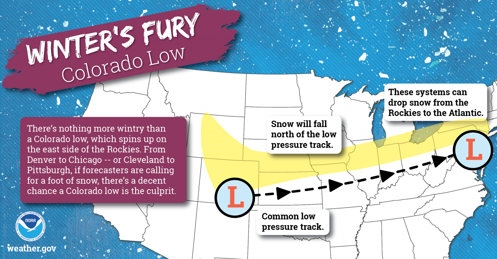
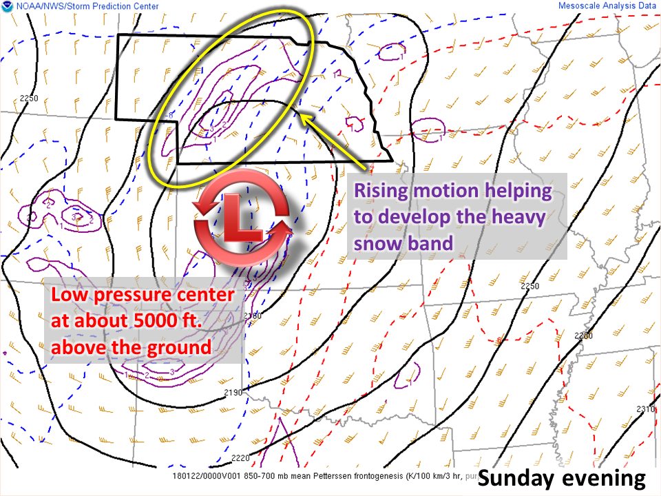
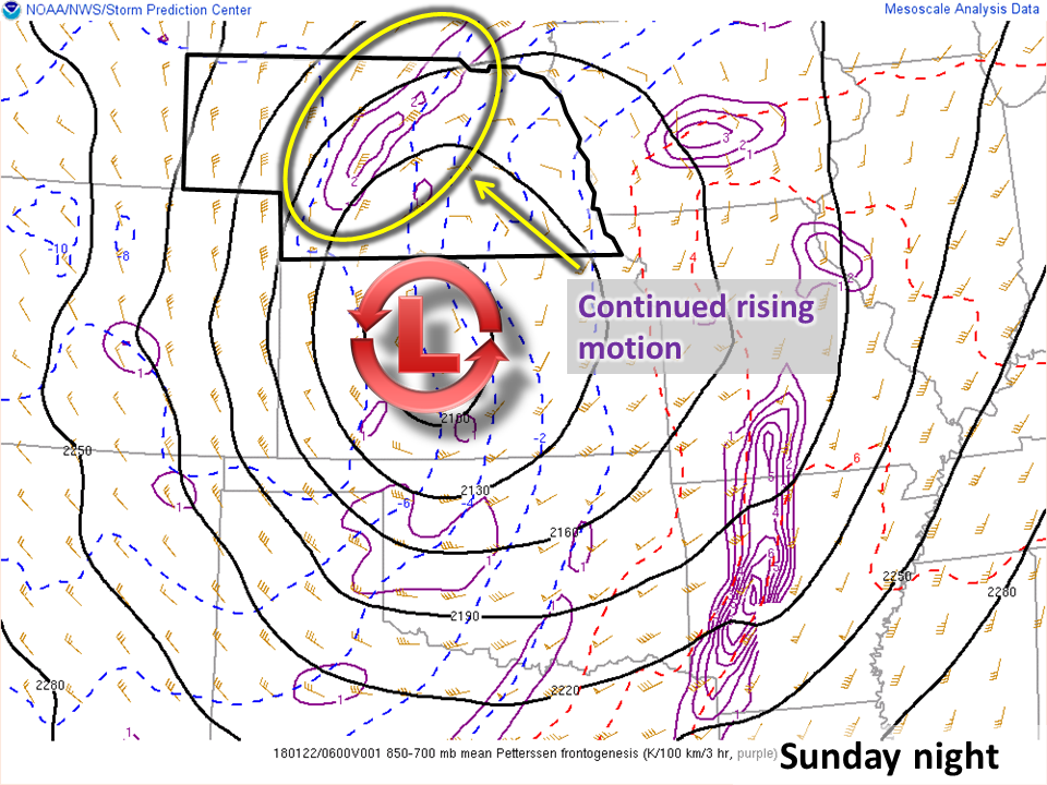
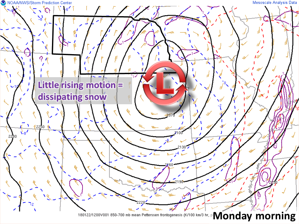
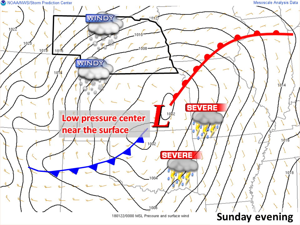
The blizzard was spawned by a strong area of low pressure moving out of the Rockies and across the Great Plains, commonly referred to as a "Colorado Low". The storm system pulled considerable moisture into the Great Plains and developed rapid rising motion. This combination led to a band of heavy wet snow across the Sandhills that accumulated at over one inch per hour. On the warm side of the system, there were strong and severe thunderstorms.
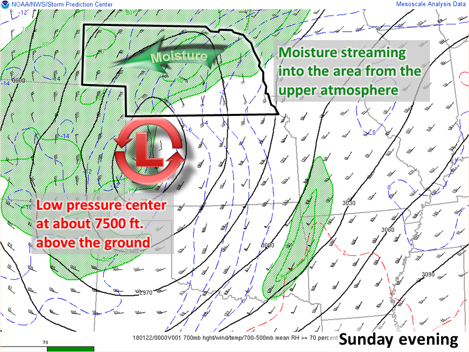
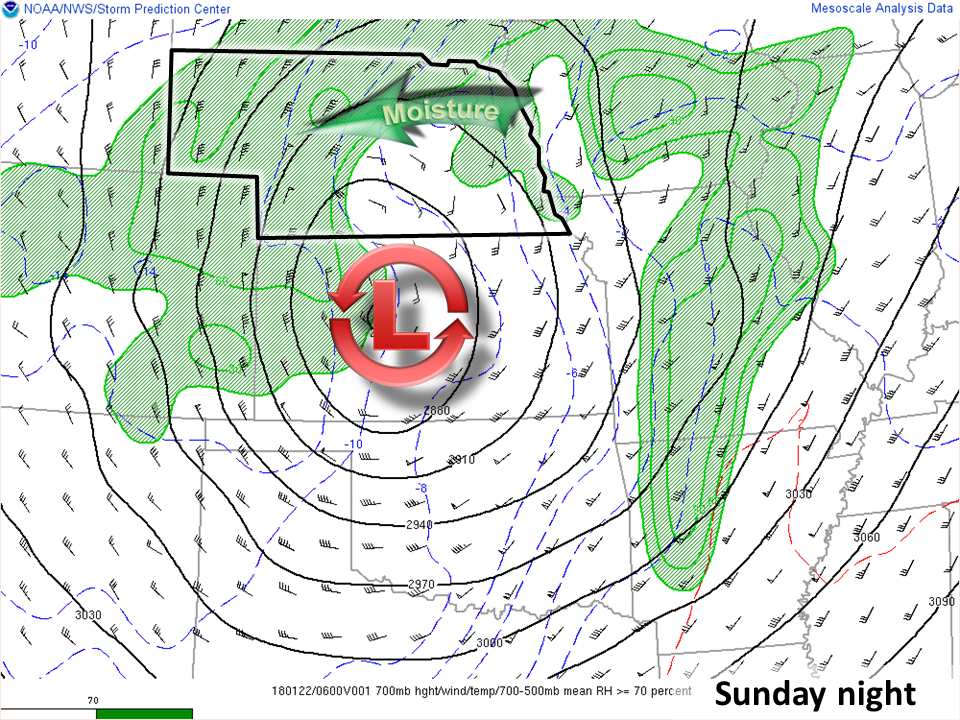
Looking at around 7500 ft. above the ground:
 |
 |
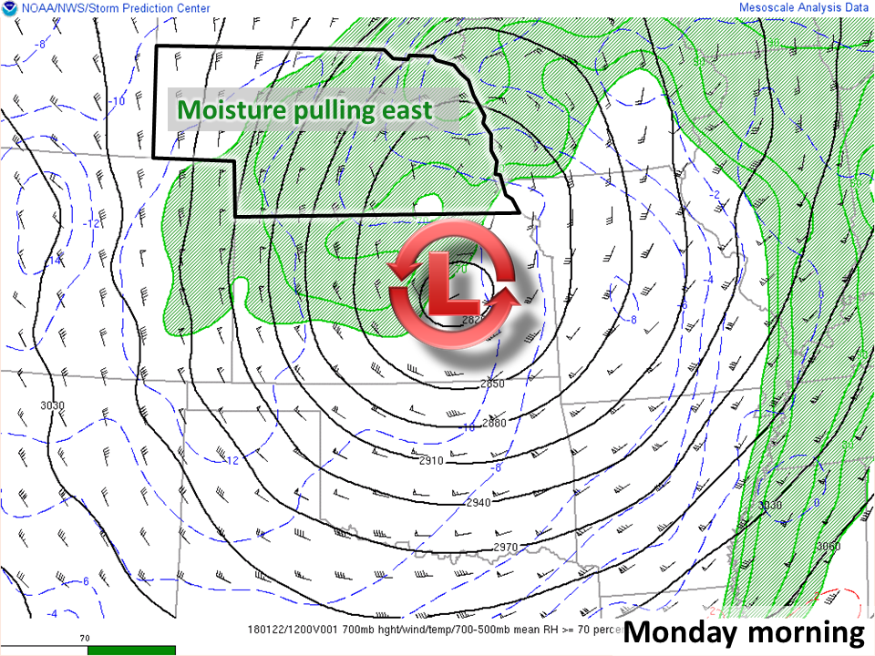 |
| Sunday evening | Sunday night | Monday morning |
Around 5000 ft. above the ground:
 |
 |
 |
| Sunday evening | Sunday night | Monday morning |
Surface map:
 |
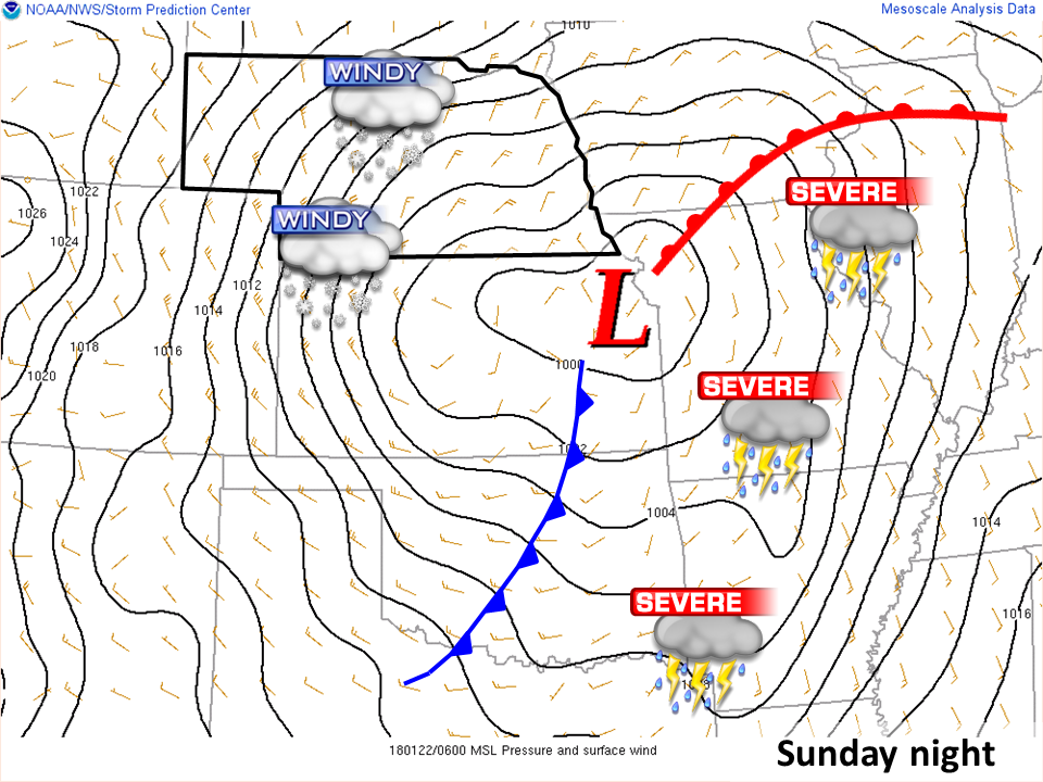 |
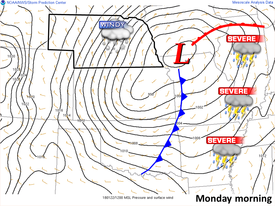 |
| Sunday evening | Sunday night | Monday morning |
Data/maps from Storm Prediction Center mesoanalysis archive
 |
Media use of NWS Web News Stories is encouraged! Please acknowledge the NWS as the source of any news information accessed from this site. |
|

