
Dangerous and extreme heat will remain across portions of the southern U.S. this week. Heavy rainfall may bring significant flash flooding across portions of the Mid-Atlantic and Northeast through the night, and additional flash flooding concerns across New England on Wednesday. Monsoonal thunderstorms will bring a flash flood risk to the Four Corners region, especially in burn scar areas Read More >
Overview
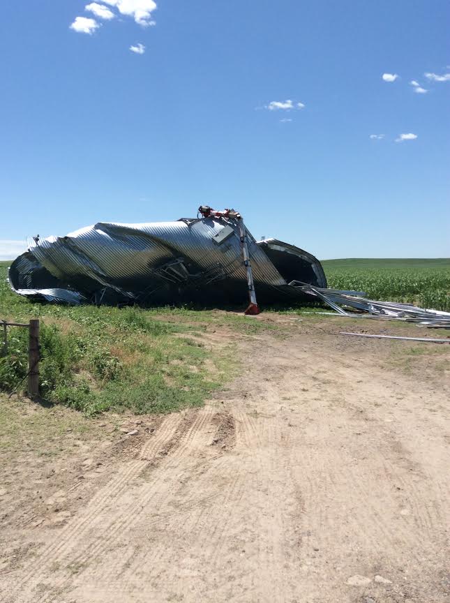
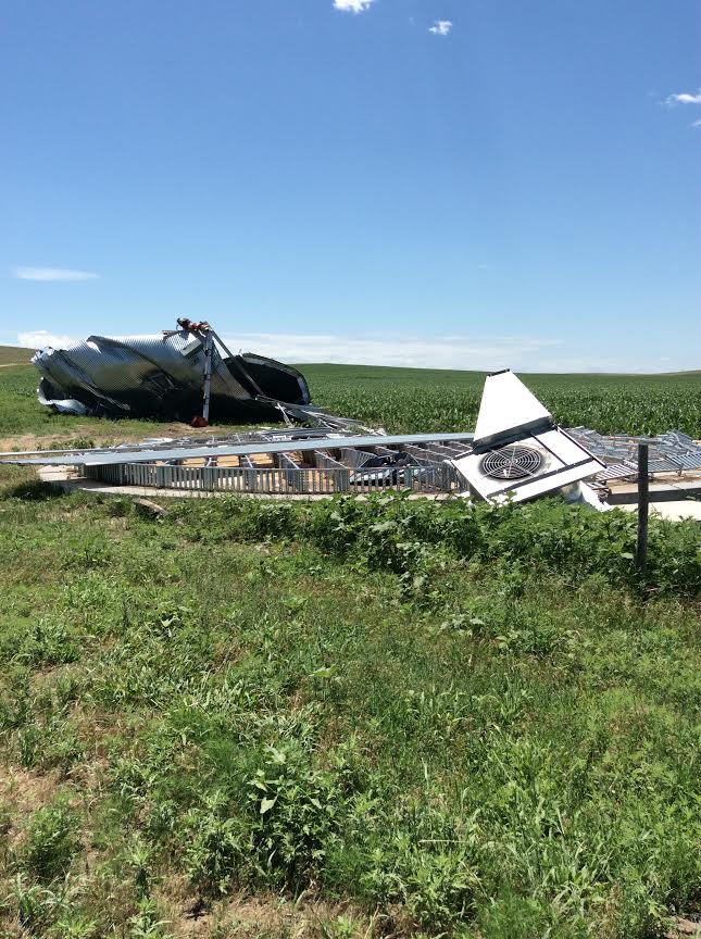
A supercell thunderstorm produced a tornado that destroyed a grain bin and flipped 90 feet of center pivot irrigation line in southwest McPherson county Wednesday evening July 6th, 2016. The same storm also produced brief tornadoes earlier in southeast Arthur county as witnessed by storm chasers in the area, however a survey of that area revealed no damage. Further damage surveys of tornadoes in Lincoln, southwest Cherry and southeast Sheridan county will be completed July 8th.Tornadoes:
|
Tornado - LOCATION
Track Map  
Downloadable KMZ File |
||||||||||||||||
The Enhanced Fujita (EF) Scale classifies tornadoes into the following categories:
| EF0 Weak 65-85 mph |
EF1 Moderate 86-110 mph |
EF2 Significant 111-135 mph |
EF3 Severe 136-165 mph |
EF4 Extreme 166-200 mph |
EF5 Catastrophic 200+ mph |
 |
|||||
Photos & Video:
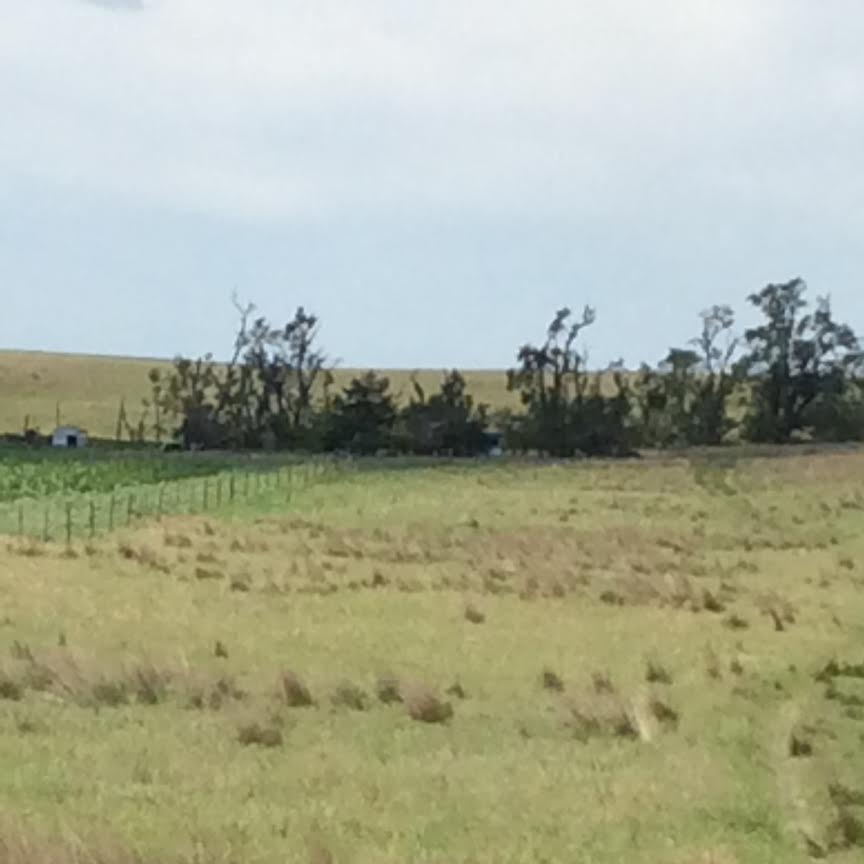
Damage Photos from the McPherson County Tornado
 |
 |
 |
 |
| Destroyed Grain Bin (NWS) |
Base of the Destroyed Grain Bin (NWS) |
Tree Damage (NWS) |
Overturned Pivot (NWS) |
Storm Reports
Public Information Statement
National Weather Service North Platte NE
1204 PM CDT THU JUL 7 2016 /1104 AM MDT THU JUL 7 2016/

...WEDNESDAY JULY 6TH 2016 SEVERE THUNDERSTORM REPORTS AND 24
HOURS RAINFALL REPORTS FROM ACROSS WESTERN AND NORTH CENTRAL
NEBRASKA...

SEVERE THUNDERSTORMS MOVED ACROSS PORTIONS OF WESTERN AND NORTH
CENTRAL NEBRASKA DURING THE LATE AFTERNOON AND EVENING HOURS ON
WEDNESDAY...JULY 6TH 2016. SOME OF THESE THUNDERSTORMS...PRODUCED
CONFIRMED TORNADOES...STRONG DAMAGING WINDS IN EXCESS OF 70 MPH...
HAIL TO THE SIZE OF GOLF BALLS...AND EVEN A LIGHTNING SPARKED
WILDFIRE. IN ADDITION TO THE SEVERE WEATHER...LOCALLY HEAVY RAIN
FELL...SUCH AS WAS THE CASE IN THE CITY OF BUTTE LOCATED IN BOYD
COUNTY...WHERE 1.48 INCHES FELL.

NATIONAL WEATHER SERVICE EMPLOYEES WILL BE OUT ACROSS PORTIONS OF
THE SANDHILLS TODAY...THURSDAY JULY 7TH...2016...TO CONDUCT DAMAGE
SURVEYS.

.....................................................................
.........   ...........      ....................... ................
..TIME...   ...EVENT...      ...CITY LOCATION...     ...LAT.LON...
..DATE...   ....MAG....      ..COUNTY LOCATION..ST.. ...SOURCE....
.........   ..REMARKS..      ....................... ................
.........   ...........      ....................... ................
.....................................................................

0418 PM     TORNADO          10 SSW HAY SPRINGS      42.55N 102.76W
07/06/2016                   SHERIDAN           NE   911 CALL CENTER

            TORNADO LIFTED.

0418 PM     TORNADO          10 SSW HAY SPRINGS      42.55N 102.76W
07/06/2016                   SHERIDAN           NE   911 CALL CENTER

            TORNADO LIFTED AT 1619 LT.

0425 PM     HAIL             15 S HAY SPRINGS        42.47N 102.69W
07/06/2016  E1.00 INCH       SHERIDAN           NE   PUBLIC

0435 PM     HAIL             8 W ARTHUR              41.57N 101.85W
07/06/2016  M1.25 INCH       ARTHUR             NE   TRAINED SPOTTER

0442 PM     HAIL             22 N LAKESIDE           42.38N 102.46W
07/06/2016  E1.00 INCH       SHERIDAN           NE   PUBLIC

0442 PM     HAIL             5 SW ARTHUR             41.52N 101.76W
07/06/2016  M1.00 INCH       ARTHUR             NE   PUBLIC

0506 PM     HAIL             10 SW ARTHUR            41.47N 101.83W
07/06/2016  E1.00 INCH       ARTHUR             NE   PUBLIC

0509 PM     HAIL             6 WSW ARTHUR            41.54N 101.80W
07/06/2016  E0.88 INCH       ARTHUR             NE   PUBLIC

0509 PM     HAIL             8 W ARTHUR              41.57N 101.85W
07/06/2016  E0.50 INCH       ARTHUR             NE   PUBLIC

0520 PM     HAIL             3 SW ARTHUR             41.54N 101.73W
07/06/2016  E0.88 INCH       ARTHUR             NE   PUBLIC

0527 PM     HAIL             3 SSW ARTHUR            41.53N 101.71W
07/06/2016  E0.88 INCH       ARTHUR             NE   PUBLIC

0547 PM     HAIL             10 NNW HAY SPRINGS      42.82N 102.76W
07/06/2016  E0.88 INCH       SHERIDAN           NE   PUBLIC

0550 PM     FUNNEL CLOUD     20 NW ASHBY             42.23N 102.21W
07/06/2016                   SHERIDAN           NE   TRAINED SPOTTER

            TRAINED SPOTTER...LOCATED 5 MILES NORTH OF ASHBY...AND
            LOOKING NORTHWEST INTO SOUTHEASTERN SHERIDAN
            COUNTY...REPORTS A FUNNEL CLOUD.

0556 PM     TORNADO          10 NNE ELLSWORTH        42.19N 102.21W
07/06/2016                   SHERIDAN           NE   TRAINED SPOTTER

            REPORTS OF A LARGE TORNADO CURRENTLY ON THE GROUND ACROSS
            SOUTHEASTERN SHERIDAN COUNTY.

0620 PM     TORNADO          9 NNW ASHBY             42.15N 102.00W
07/06/2016                   CHERRY             NE   TRAINED SPOTTER

            MULTIPLE VORTEX TORNADO...SHORTLY BEFORE BECOMING RAIN
            WRAPPED.

0627 PM     TSTM WND GST     7 E MERRITT RESERVOIR D 42.65N 100.73W
07/06/2016  E60.00 MPH       CHERRY             NE   PUBLIC

0652 PM     FUNNEL CLOUD     10 N HYANNIS            42.15N 101.76W
07/06/2016                   CHERRY             NE   TRAINED SPOTTER

0658 PM     TSTM WND GST     1 SSE VALENTINE         42.86N 100.54W
07/06/2016  M58.00 MPH       CHERRY             NE   ASOS

0700 PM     TSTM WND GST     13 SW MULLEN            41.91N 101.22W
07/06/2016  E60.00 MPH       HOOKER             NE   PUBLIC

0703 PM     FUNNEL CLOUD     15 NE HYANNIS           42.15N 101.55W
07/06/2016                   CHERRY             NE   TRAINED SPOTTER

0735 PM     HAIL             7 ESE ARTHUR            41.53N 101.57W
07/06/2016  E1.75 INCH       ARTHUR             NE   PUBLIC

0744 PM     TSTM WND GST     2 SE SPRINGVIEW         42.80N 99.72W
07/06/2016  E60.00 MPH       KEYA PAHA          NE   PUBLIC

0755 PM     TORNADO          15 SE ARTHUR            41.42N 101.49W
07/06/2016                   ARTHUR             NE   TRAINED SPOTTER

            ESTIMATED LOCATION.

0800 PM     HAIL             4 NE SUTHERLAND         41.20N 101.07W
07/06/2016  M1.75 INCH       LINCOLN            NE   PUBLIC

0808 PM     TORNADO          15 SW TRYON             41.40N 101.15W
07/06/2016                   MCPHERSON          NE   TRAINED SPOTTER

0811 PM     TSTM WND GST     12 N STUART             42.77N 99.14W
07/06/2016  E60.00 MPH       HOLT               NE   PUBLIC

0815 PM     TSTM WND GST     7 N TRYON               41.66N 100.94W
07/06/2016  E70.00 MPH       MCPHERSON          NE   PUBLIC

            HAIL INCH HAIL WITH THE WIND.

0845 PM     TSTM WND GST     SUTHERLAND              41.16N 101.13W
07/06/2016  E60.00 MPH       LINCOLN            NE   PUBLIC

0845 PM     HAIL             2 N NORTH PLATTE        41.16N 100.77W
07/06/2016  M1.00 INCH       LINCOLN            NE   AMATEUR RADIO

0845 PM     HAIL             11 NNE HERSHEY          41.31N 100.92W
07/06/2016  M1.75 INCH       LINCOLN            NE   FIRE DEPT/RESCUE

0905 PM     TSTM WND GST     5 N NORTH PLATTE        41.21N 100.77W
07/06/2016  M68.00 MPH       LINCOLN            NE   TRAINED SPOTTER

0905 PM     TSTM WND GST     5 N NORTH PLATTE        41.21N 100.77W
07/06/2016  M72.00 MPH       LINCOLN            NE   TRAINED SPOTTER

0912 PM     HAIL             3 N NORTH PLATTE        41.18N 100.77W
07/06/2016  M1.50 INCH       LINCOLN            NE   NWS EMPLOYEE

            70 MPH WINDS.

0914 PM     TSTM WND GST     4 NNE NORTH PLATTE      41.19N 100.74W
07/06/2016  M69.00 MPH       LINCOLN            NE   MESONET

0915 PM     TSTM WND GST     3 N NORTH PLATTE        41.18N 100.77W
07/06/2016  M78.00 MPH       LINCOLN            NE   NWS EMPLOYEE

0915 PM     HAIL             6 N NORTH PLATTE        41.22N 100.77W
07/06/2016  E1.75 INCH       LINCOLN            NE   PUBLIC

            VIA SOCIAL MEDIA

0928 PM     TORNADO          2 NW BRADY              41.04N 100.39W
07/06/2016                   LINCOLN            NE   PUBLIC

            PUBLIC ESTIMATED LOCATION.

0939 PM     WILDFIRE         5 W HAYES CENTER        40.51N 101.12W
07/06/2016                   HAYES              NE   EMERGENCY MNGR

            SPARKED BY LIGHTNING...THE RAIN PUT IT OUT.

0940 PM     TSTM WND GST     11 NNE BRADY            41.17N 100.29W
07/06/2016  E60.00 MPH       LINCOLN            NE   PUBLIC

            DELAYED REPORT. TIME ESTIMATED OFF OF RADAR. RESIDENT
            STATED THAT THERE WAS ONE STRONG GUST OF WIND...BUT AFTER
            THAT NO HAIL OR RAIN.

0940 PM     TSTM WND GST     BROKEN BOW              41.41N 99.64W
07/06/2016  M60.00 MPH       CUSTER             NE   ASOS

0945 PM     TSTM WND GST     4 S ARNOLD              41.37N 100.19W
07/06/2016  E60.00 MPH       CUSTER             NE   PUBLIC

            DELAYED REPORT. TIME ESTIMATED OFF OF RADAR.

0950 PM     TSTM WND GST     11 NNW NORTH PLATTE     41.28N 100.85W
07/06/2016  E60.00 MPH       LINCOLN            NE   PUBLIC

            DELAYED REPORT. TIME ESTIMATED ON RADAR.

1030 PM     HAIL             15 NE NORTH PLATTE      41.29N 100.57W
07/06/2016  E1.75 INCH       LINCOLN            NE   NWS EMPLOYEE
 |
Media use of NWS Web News Stories is encouraged! Please acknowledge the NWS as the source of any news information accessed from this site. |
|

