
Dangerous and extreme heat will remain across portions of the southern U.S. this week. Heavy rainfall may bring significant flash flooding across portions of the Mid-Atlantic and Northeast through the night, and additional flash flooding concerns across New England on Wednesday. Monsoonal thunderstorms will bring a flash flood risk to the Four Corners region, especially in burn scar areas Read More >
Overview
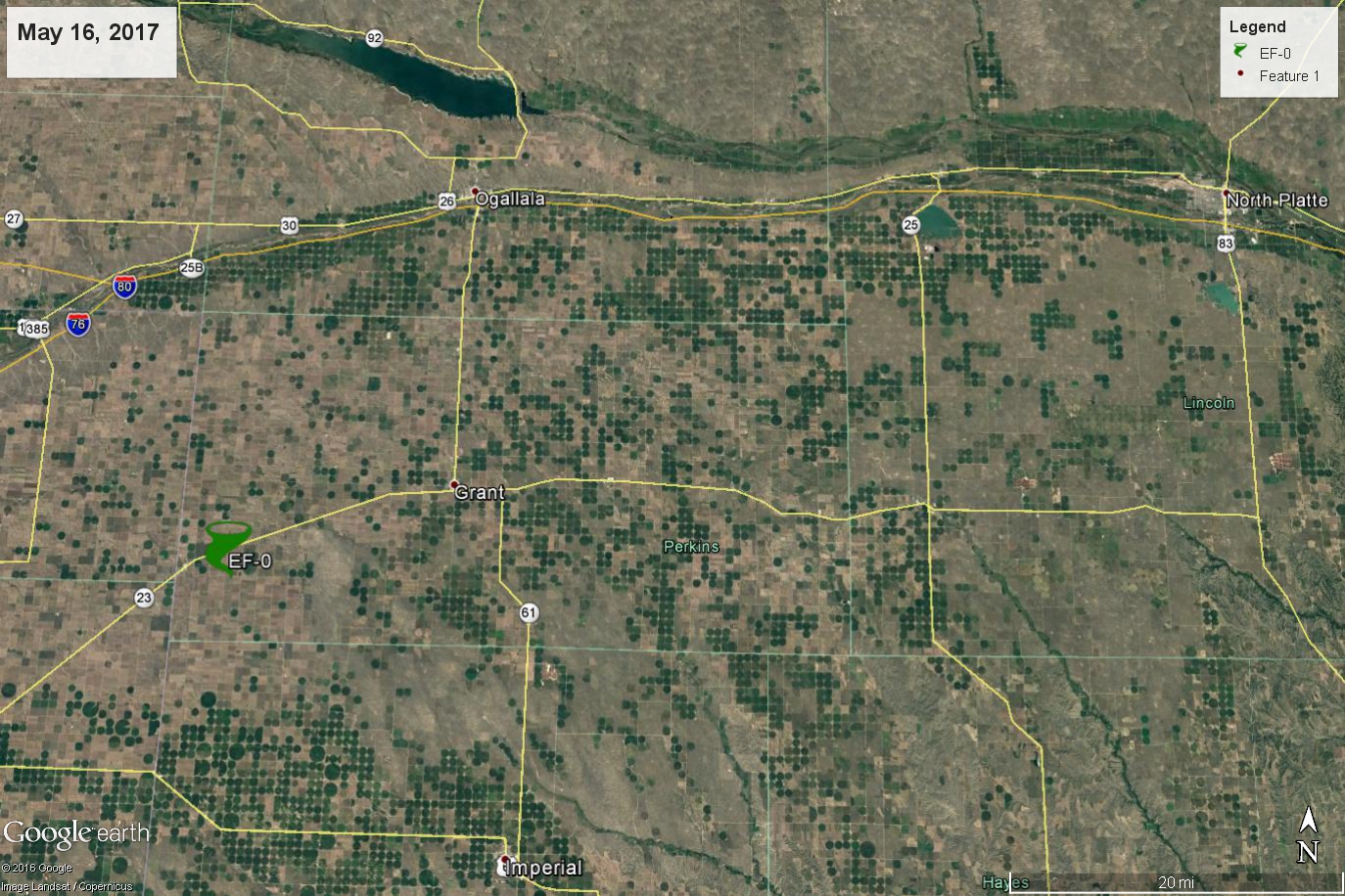
A line of thunderstorms moved east out of Colorado into southwest Nebraska Tuesday evening, May 16th. A supercell was embedded within the line which produced a brief weak tornado just west of Grant. No damage occurred from this tornado.
This was not an "ideal" set-up for tornadoes but this area between Imperial and Ogallala was identified as an area where there might be some potential because an old outflow boundary set up in western Perkins County. So when a severe thunderstorm moved across this boundary, the low level shear was briefly enhanced enough to spawn a tornado. Luckily, a retired NWS Employee and prolific researcher was in the area to document the event because we do not have much radar coverage in that part of our forecast area. Check out the Radar tab for more information on Radar and its limitations in this case.
Tornadoes:
|
Tornado - 5 Miles SW of Brandon, NE
|
||||||||||||||||
The Enhanced Fujita (EF) Scale classifies tornadoes into the following categories:
| EF0 Weak 65-85 mph |
EF1 Moderate 86-110 mph |
EF2 Significant 111-135 mph |
EF3 Severe 136-165 mph |
EF4 Extreme 166-200 mph |
EF5 Catastrophic 200+ mph |
 |
|||||
Photos & Video:
Photo By Researcher and Former National Weather Service Employee, David Blanchard:
 |
 |
 |
|
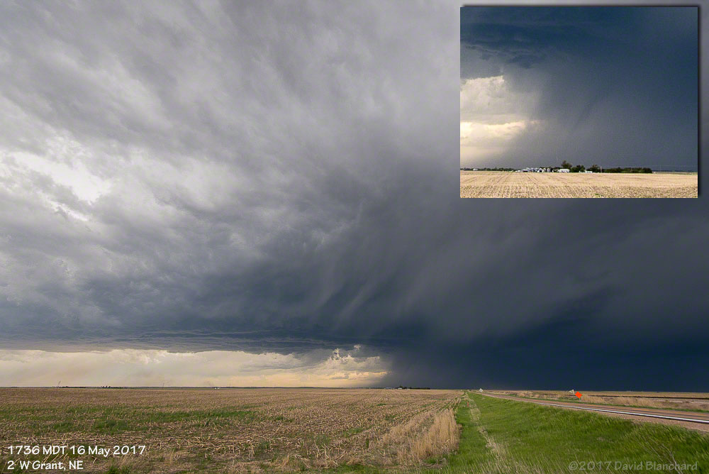
| Tornado pictured just to the right of center in this picture, just inside the rain shaft. The inset in the top right of the photo was enhanced by the photographer so that the tornado would stand out. D Blanchard |
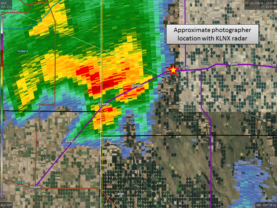
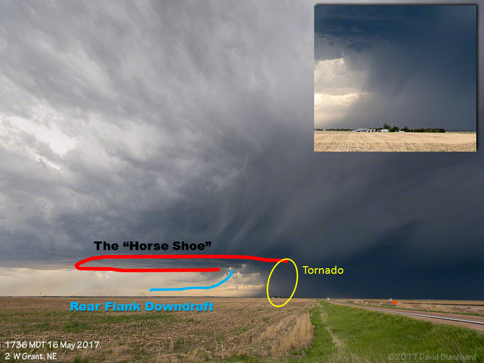
Radar Data at the time the photo was taken, and the location of the photographer | While the tornado is rain wrapped and might look like, at first glance, it is not where it is "supposed" to be [in the updraft portion of the storm]. You can see that it is at the tip of the "horseshoe" - sometimes the updraft portion of the storm can take on a horseshoe like appearance, tornadoes are usually found on the north end of the horseshoe. |
Radar: Radar Has Its Limitations
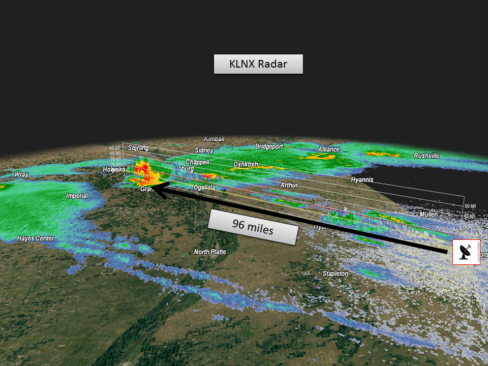
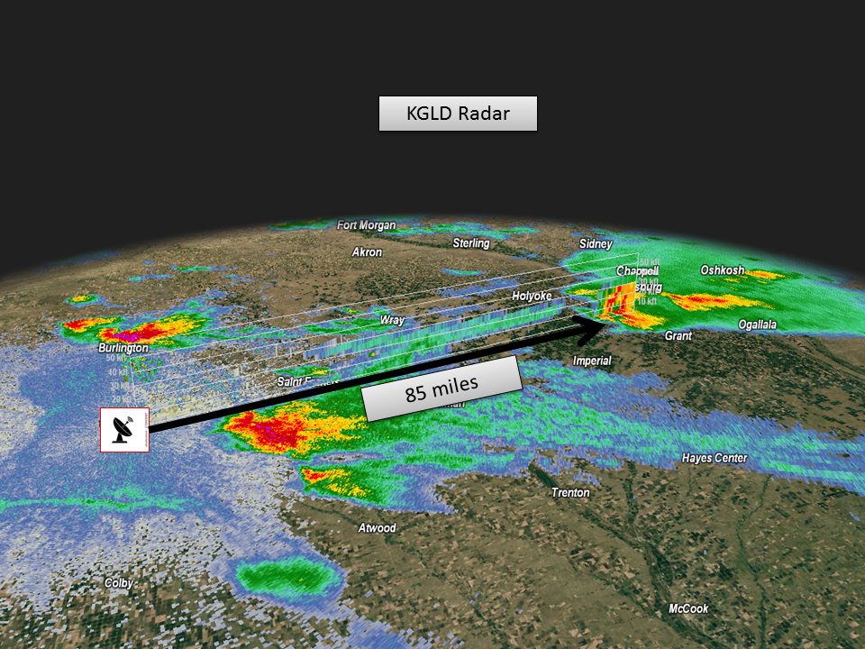
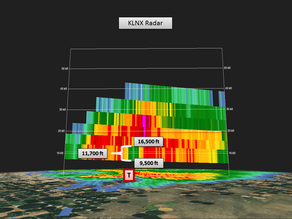
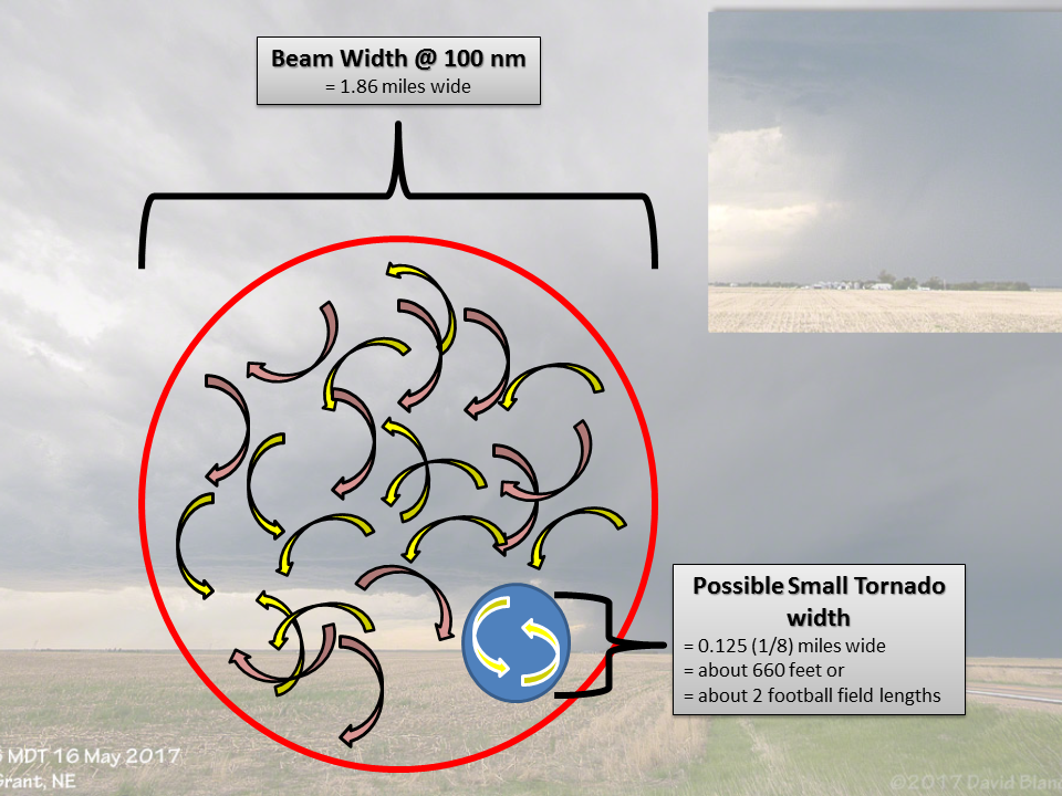
This particular tornado occurred in a location with poor low level radar coverage. The tornado was about 96 miles from our radar in Thedford, and it was about 85 miles from Goodland's radar. This presents some challenges for the radar to view a circulation this small, relative to the width of the radar beam. In addition, the lowest elevation that our radar could see was about 11,000 feet above the surface.
 |
 |
 |
 |
| Storm Location Relative To Our Radar in Thedford | Storm Location Relative to Goodland's Radar | By the time the radar beam got to Perkins County, the lowest we could see into the storm was 9,500 ft! | Because of the curvature of the Earth's surface, the radar beam's lowest elevation slice rises higher and higher as you travel from the Radar. So by the time the beam hit the storm, the beam width was much larger and the beam height was much higher than it is when you're near the source. |
 |
 |
||
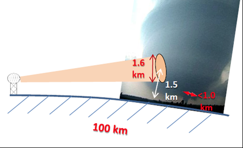
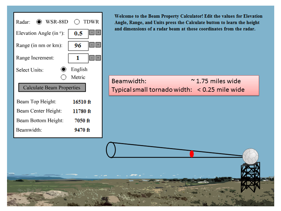
| The beam width was approximately 1.75 miles wide by the time it sampled the storm. A typical small tornado is less than one quarter of a mile wide. | Depiction of the tornadic circulation relative to beam width |
Storm Reports
Public Information Statement
National Weather Service North Platte NE
412 PM CDT Wed May 17 2017 /312 PM MDT Wed May 17 2017/

...BRIEF TORNADO REPORTED IN PERKINS COUNTY TUESDAY EVENING...

A storm moving out of Colorado strengthened as it entered Perkins
County early Tuesday evening. The storm spawned a brief tornado
west of Brandon, lasting about one minute and producing no damage.
Large hail up to ping pong ball size was also reported in and
around Grant.

.TORNADO #1...

Rating:                 EF-0
Estimated peak wind:    65 mph
Path length /Statute/:  0.1 miles
Path width /Maximum/:   20 yards
Fatalities:             0
Injuries:               0

Start date:             05/16/2017
Start time:             5:36 PM MDT
Start location:         5 miles WSW of Brandon

End date:               05/16/2017
End time:               5:37 PM MDT
End location:           5 miles WSW of Brandon


EF Scale: The Enhanced Fujita Scale Classifies
Tornadoes into the following categories.

EF0...Weak......65 to 85 mph
EF1...Weak......86 to 110 mph
EF2...Strong....111 to 135 mph
EF3...Strong....136 to 165 mph
EF4...Violent...166 To 200 mph
EF5...Violent...>200 mph

NOTE:
The information in this statement is PRELIMINARY and subject to
change pending final review of the event and publication in
NWS Storm Data.
 |
Media use of NWS Web News Stories is encouraged! Please acknowledge the NWS as the source of any news information accessed from this site. |
|

