
Severe thunderstorms which can bring large hail, damaging winds, and isolated tornadoes will be possible over parts of the central U.S. through this weekend. Thunderstorms with heavy to excessive rainfall moving from Texas into the mid-Mississippi Valley through this weekend may produce areas of flooding. Read More >
North Platte, NE
Weather Forecast Office
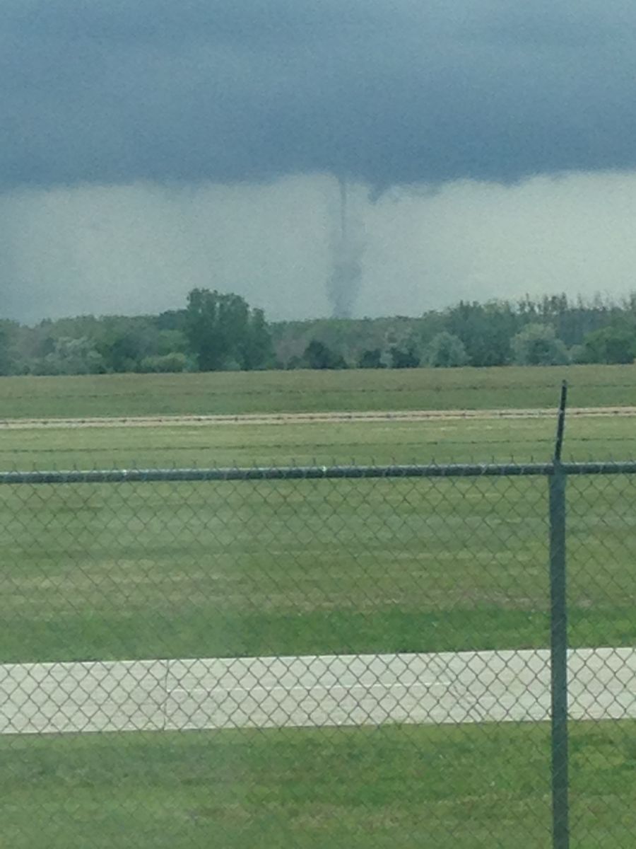
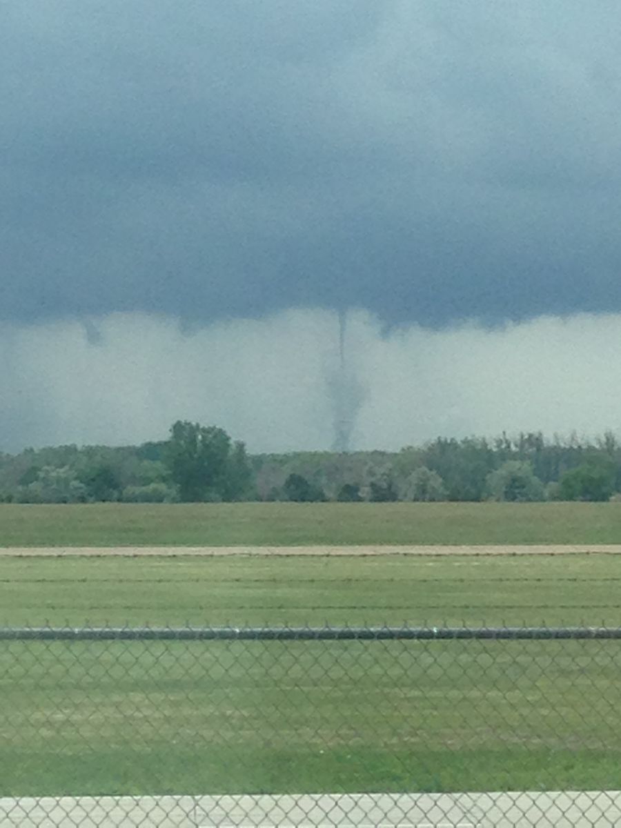
A thunderstorm developed just southwest of Maxwell around noon Sunday. The thunderstorm drifted slowly to the west, and produced a brief weak tornado about 7 miles south southeast of North Platte at 12:25 p.m. CDT. The tornado was on the ground for three to four minutes, and drifted slowly to the west while it was on the ground. The tornado touched down in open rangeland with no damage reported. The tornado details known include:
.TORNADO #1...

RATING: EF-0
PATH LENGTH /STATUTE/: 0.50 MILES
PATH WIDTH /MAXIMUM/: 25 YARDS
FATALITIES: 0
INJURIES: 0

START DATE: JUN 14 2015
START TIME: 1225 PM CDT
START LOCATION: 7.5 MILES SSE OF NORTH PLATTE/LINCOLN COUNTY/NEBRASKA
START LAT/LON: 41.04N/-100.69W

END DATE: JUN 14 2015
END TIME: 1229 PM CDT
END LOCATION: 7.0 MILES SSE OF NORTH PLATTE/LINCOLN COUNTY/NEBRASKA
END LAT/LON: 41.04N/-100.71W

NO DAMAGE WAS REPORTED FROM THE TORNADO.

EF SCALE: THE ENHANCED FUJITA SCALE CLASSIFIES TORNADOES INTO THE
FOLLOWING CATEGORIES.

EF0...WEAK......65 TO 85 MPH
EF1...WEAK......86 TO 110 MPH
EF2...STRONG....111 TO 135 MPH
EF3...STRONG....136 TO 165 MPH
EF4...VIOLENT...166 TO 200 MPH
EF5...VIOLENT...>200 MPH
NOTE: The information is preliminary and subject to change pending final review of the event and publication in NWS Storm Data. |
Pictures of the tornado taken from the North Platte Weather Service office at 12:25 p.m. are shown below and found on the NWS North Platte Facebook page.
 |
 |
.JPG) |
HAZARDS
Active Alerts
National Radar
National Hurricane Center
Storm Prediction Center
Weather Prediction Center
River Flooding
Decision Support
Submit a Storm Report
Recent Storm Reports
CURRENT CONDITIONS
CoCoRaHS
Enhanced Data Display
Local Radar
National Radar Mosiac
Observations
National Snow Cover
Precipitation Mapped
Regional Links
Satellite
Snowfall Analysis
FORECASTS
Area Forecast Discussion
Aviation Weather Center
Local Aviation Weather
Fire Weather
Recreation Forecast
National Graphical Forecast
Local Graphical Forecast
CLIMATE
Local Climate
National Climate
North Platte - Daily
North Platte - Monthly
Valentine - Daily
Valentine - Monthly
Broken Bow - Daily
Broken Bow - Monthly
Imperial - Daily
Imperial - Monthly
NIDIS Drought
NOAA Climate Science
Local Storm Reports
Local Drought Statement
US Dept of Commerce
National Oceanic and Atmospheric Administration
National Weather Service
North Platte, NE
5250 E. Lee Bird Drive
North Platte, NE 69101-2473
308-532-4936
Comments? Questions? Please Contact Us.

