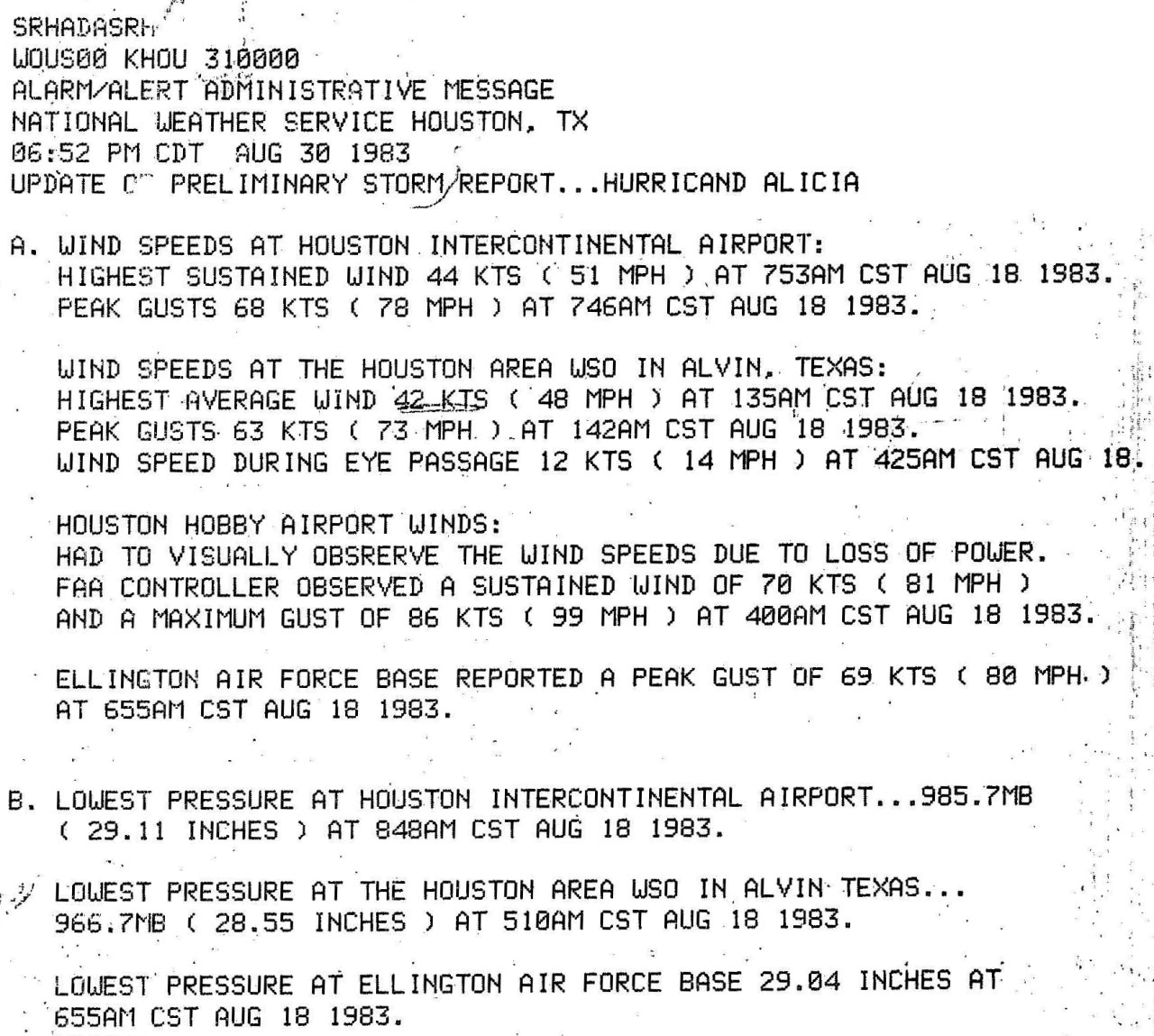
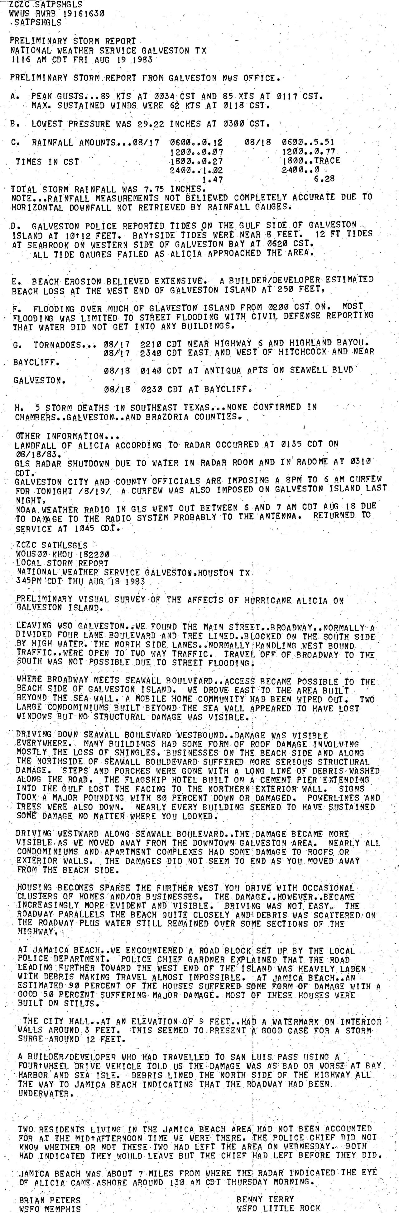
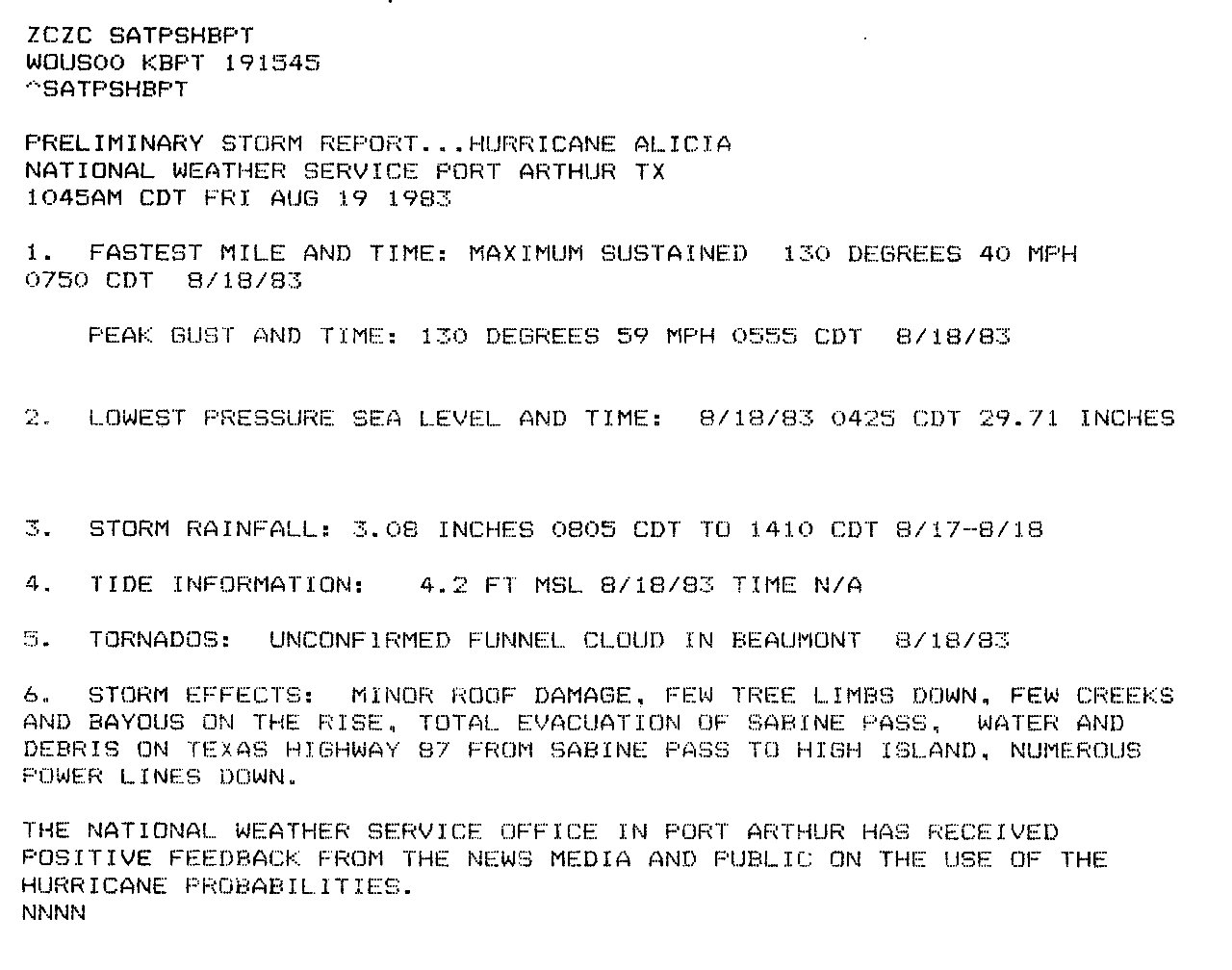
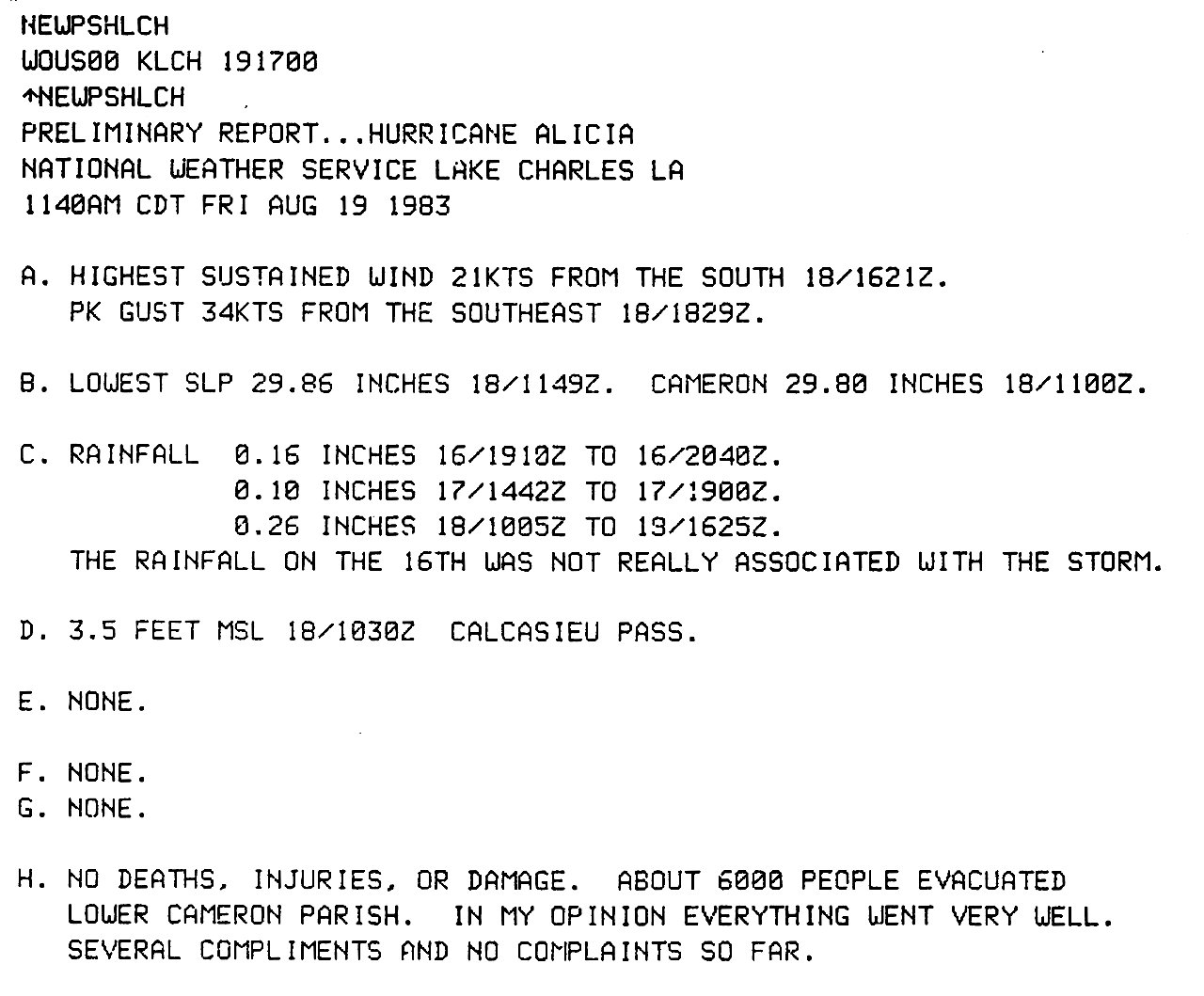
|
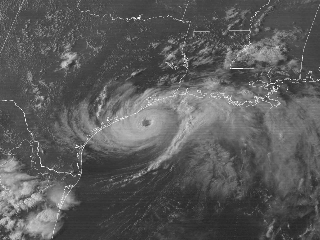
Above: GOES-5 visible satellite image of Hurricane Alicia off the Southeast Texas Coast at 5:31 PM CDT August 17, 1983.
Hurricane Alicia originated from the interaction of a meso-scale low pressure area that moved off the Louisiana coast on August 14th and a stalled frontal trough across the Northern Gulf. The area developed into a tropical depression around daybreak on August 15th about 120 miles south of the Southeast Louisiana Coast. A mid to upper level ridge over the Central United States steered the system westward. With little wind shear and warm Gulf waters in the middle 80s, the depression strengthened to Tropical Storm Alicia by the afternoon.
Alicia steadily strengthened as it slowly headed west around 5 mph through August 16th. A gradual turn towards the west northwest began later that afternoon, with Alicia strengthening to hurricane strength by 7 PM CDT that evening. Slow strengthening continued into the overnight hours. As the mid to upper level ridge over the Central United States shifted slightly east, Alicia began to turn more northwest towards the Southeast Texas coast.
Although Alicia remained a small hurricane, significant improvement in the structure was noted by satellite and radar imagery from Galveston and Lake Charles WSR-57 radars. GOES-5 visible satellite image at 10 AM CDT August 17th shows the formation of a nearly clear eye. Alicia continued to move northwest and strengthened to a category two hurricane with winds of 105 mph (90 knots) by 1 PM CDT, and 110 mph (95 knots) winds by 7 PM CDT. A GOES-5 visible satellite image at 5:31 PM CDT August 17th shows a well-defined structure and eye. The National Weather Service WSR-57 radar photograph (post storm colorized by the Hurricane Research Division) at 8:51 PM CDT August 17th shows a strengthening hurricane with very well structured spiral rain bands and eyewall.
Alicia strengthened further to a category three hurricane shortly before landfall around 2 AM CDT August 18th near San Luis Pass, Texas with maximum sustained winds of 115 mph (100 knots) and a minimum sea level pressure of 962 millibars (28.41 inches). Alicia’s eye passed over the National Weather Service in Alvin, TX around 5:25 AM CDT with the station measuring a minimum sea level pressure of 966.8 millibars (28.55 inches). Alicia weakened to 90 mph (80 knots) by 7 AM CDT with the eye passing directly over the Houston Metropolitan Area. Alicia further weakened to a tropical storm by 1 PM CDT, passing just east of College Station, Texas, and a tropical depression by Midnight August 19th, passing just west of the Dallas/Fort Worth Metroplex. Tropical Depression Alicia continued north northwest across Western Oklahoma, becoming extratropical on August 20th across Kansas. Click here for an interactive track of Hurricane Alicia.
Although Alicia was a smaller than average size hurricane, it made landfall as a category 3 hurricane on the west end of Galveston Island with the eye passing over the western half of the Houston Metropolitan area. With this track, the highest storm surge occurred across Galveston Island, and most areas around Galveston Bay. Also, the strongest winds occurred from Galveston to Houston. Total damages from the winds, storm surge, and tornadoes caused by Alicia totaled nearly 3 billion dollars, making Alicia the costliest hurricane in Texas history at the time. Twenty-one direct deaths have been attributed to Hurricane Alicia.
WIND & PRESSURE:
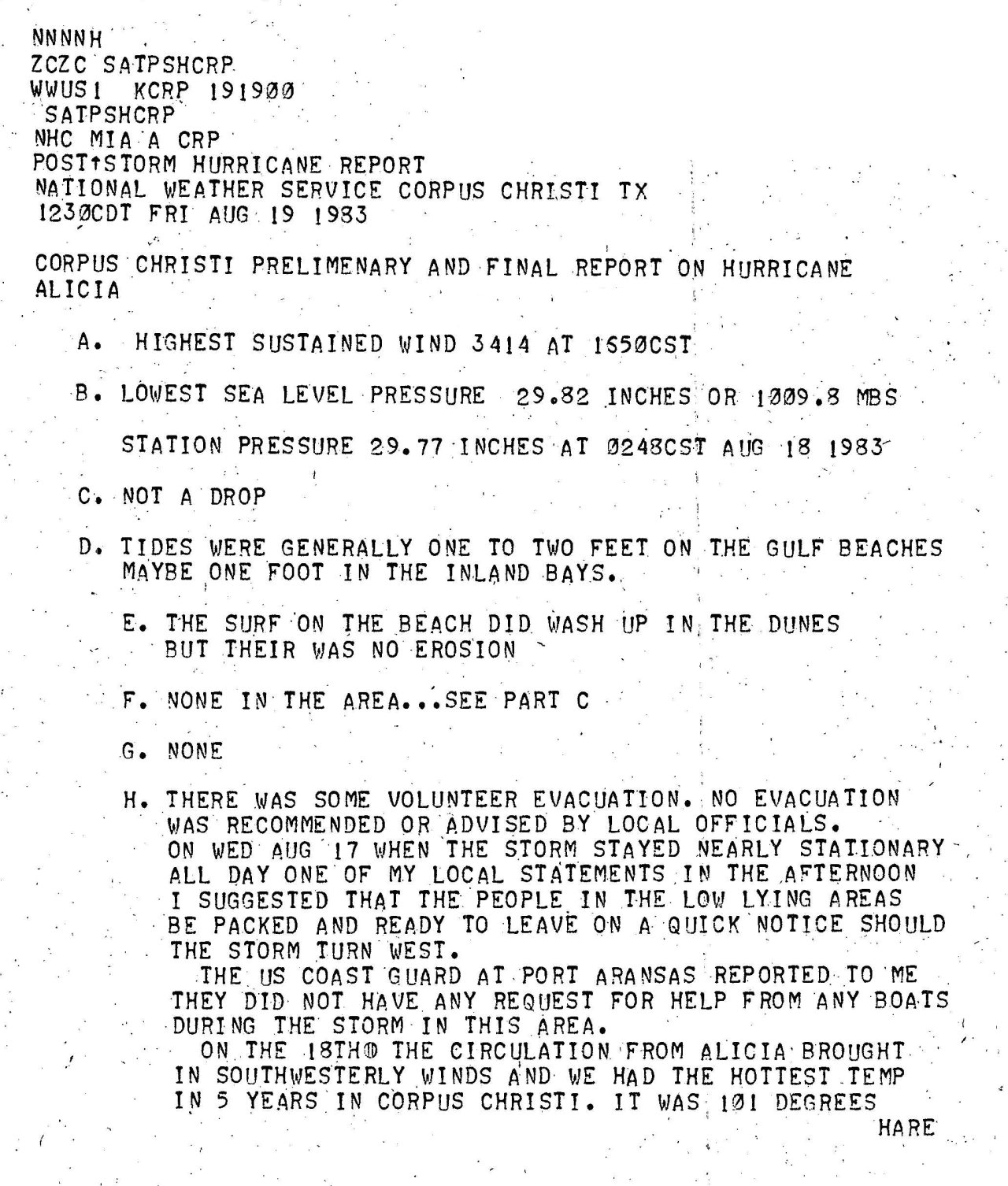
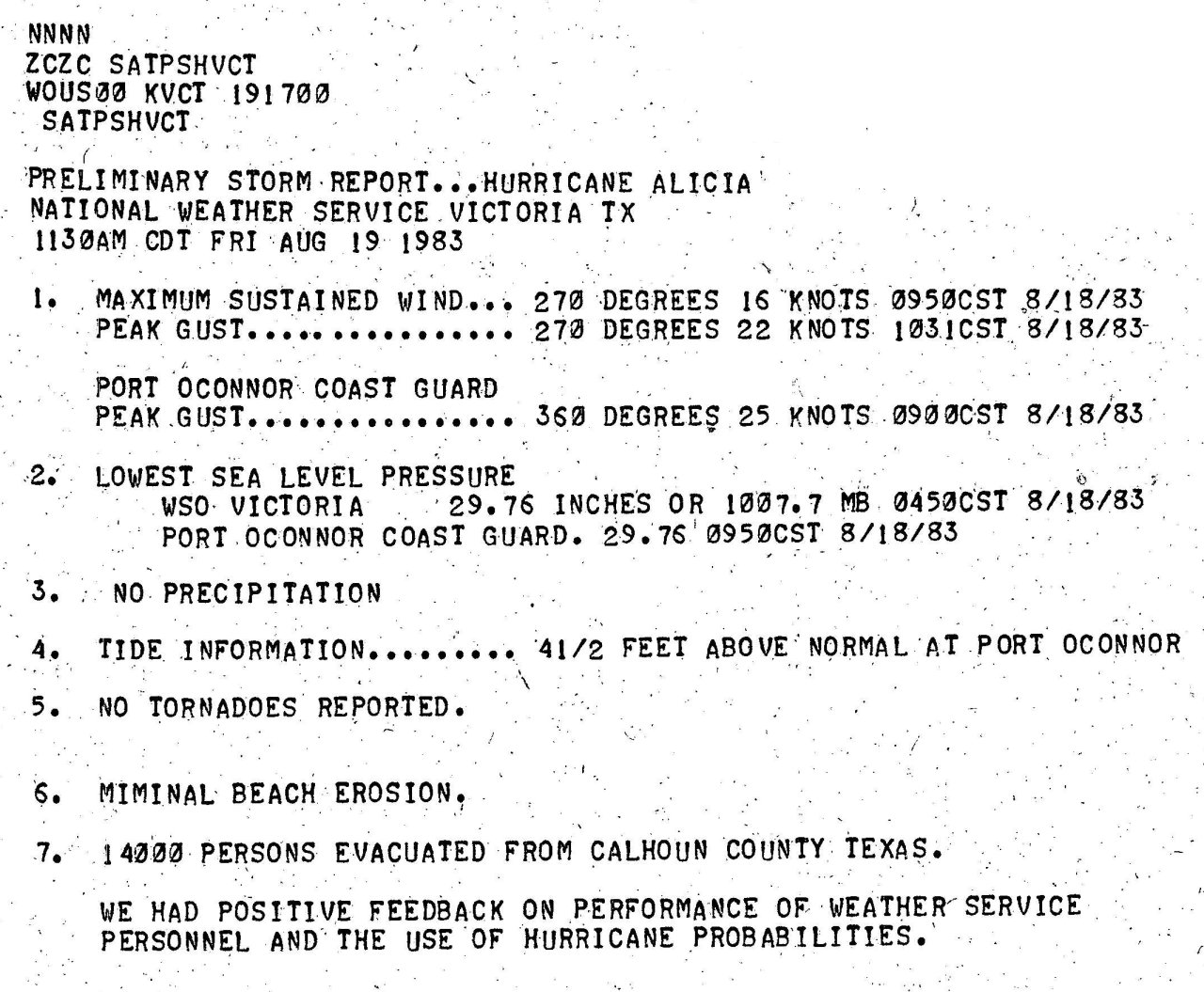
Sustained tropical storm force winds occurred across Southeast Texas, with gusts near 30 to 40 mph across South Louisiana in the passing squalls. The National Weather Service in Port Arthur, Texas measured a maximum sustained wind of 40 mph (35 knots) at 7:50 AM CDT, a peak wind gust of 59 mph (51 knots) at 5:55 AM CDT, and a minimum sea level pressure of 1006.1 mb (29.71") at 4:25 AM CDT on August 18th. Further west across the Bolivar Peninsula, Galveston Island and western Galveston Bay, sustained winds of 70 to 80 mph with gusts near 100 mph occurred. The National Weather Service in Galveston, Texas measured a maximum sustained wind of 71 mph (62 knots) at 2:17 AM CDT, a peak wind gust of 102 mph (89 knots) at 1:34 AM CDT, and a minimum sea level pressure of 989.5 mb (29.22") at 3:00 AM CDT on August 18th. For complete meteorological statistics, see the Wind and Pressure section.
STORM SURGE:
Due to the small circulation of Alicia, maximum tide levels of 8 to 12 feet MSL were mainly confined west of High Island, Texas to the Bolivar Peninsula, Galveston Island and Galveston Bay, with the highest high-water mark of 12.6 feet recorded near San Luis Pass, TX near where the eye of Hurricane Alicia made landfall. East of High Island, Texas, tides of 4 to 5 feet MSL occurred across coastal Jefferson County in Southeast Texas, and 3 to 4 feet MSL across coastal Cameron Parish in Southwest Louisiana. For other storm surge and high-water marks, see the Storm Surge section.
RAINFALL:
Rainfall of 5 to 9 inches occurred across Southeast Texas near and just east of the eye of Alicia with the highest total of 9.50 inches recorded in Liberty, Texas. Further east across Southeast Texas within our area of responsibility, rainfall of 2 to 4 ½ inches occurred, with the highest total of 4.54 inches at a Coop site in Warren, Texas. Rainfall of 1 to 2 ½ inches occurred across Southern Louisiana, mainly with the passing squalls, and less than an inch further north across Central Louisiana. For complete rainfall totals reported across our region, see the Rainfall section.
TORNADOES:
Many F0 tornadoes were reported across Galveston, Harris, and Brazoria counties just west of our region. The strongest tornado rated F2 was recorded in Navarro County in North Texas that caused a quarter of a million dollars in property damage. Fortunately, no injuries or deaths were reported. No tornadoes were recorded across our region of Southeast Texas and Louisiana. For complete details on all the tornadoes reported in Texas, see the Tornadoes section.
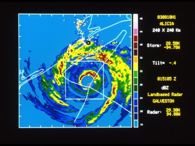
Above: NWS Galveston, TX WSR-57 radar photograph of Hurricane Alicia south of Galveston, TX at 8:51 PM CDT August 17, 1983.
|


