|
On March 8, 2023, the National Weather Service office in Lake Charles, LA (LCH) completed changes to the Public and Fire Weather Forecast Zones encompassing Acadia, Calcasieu, Iberia, Jefferson Davis, St. Mary and Vermilion Parishes in Southwest and South-Central Louisiana, as well as Jefferson and Orange Counties in Southeast Texas.
These changes are intended to provide increased flexibility and improved accuracy of forecast, watch, warning, and advisory products.
The existing zones were divided for improvements in warnings, watches, advisories, and forecasts for coastal flooding and storm surge events, as well as to better target storm surge warning dissemination through the Wireless Emergency Alert system. The new zone divisions roughly account for storm surge threats posed by most category 2 and lower hurricanes along with feedback provided by local emergency officials for the areas they use to describe local evacuations. The changes to the parish and county zones are described below:
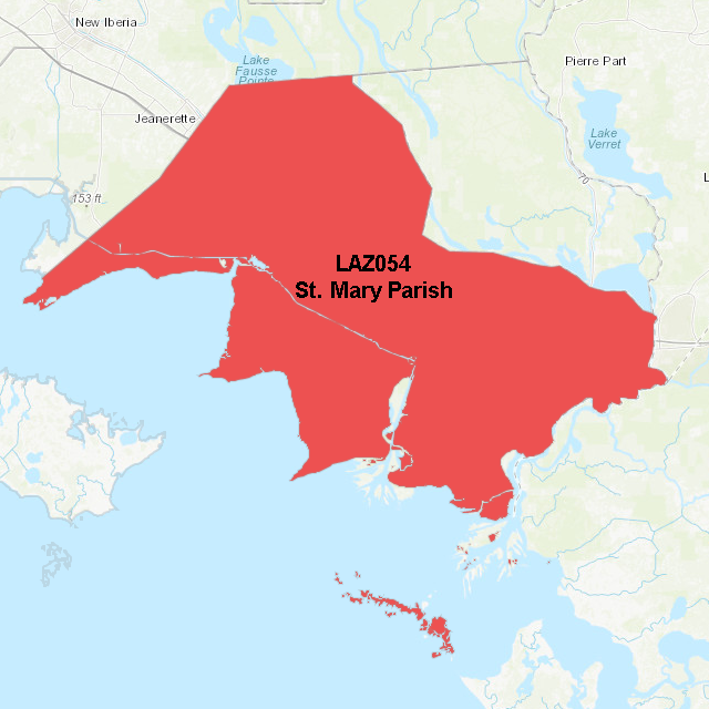
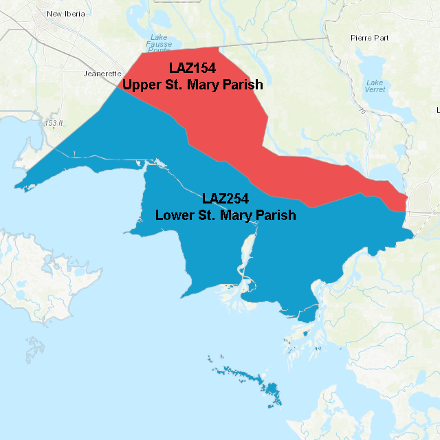
St. Mary Parish: The zone split was along U.S. Highway 90 and created Upper St. Mary Parish and Lower St. Mary Parish.
| St. Mary Parish before change |
St. Mary Parish after change |
 |
 |
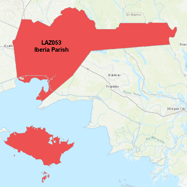
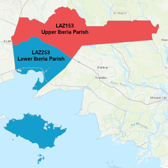
Iberia Parish: The zone split was along Louisiana Highway 14 until its intersection with U.S. Highway 90, continuing along U.S. 90 to the parish line with St. Mary. This change created Upper Iberia Parish and Lower Iberia Parish.
| Iberia Parish before change |
Iberia Parish after change |
 |
 |
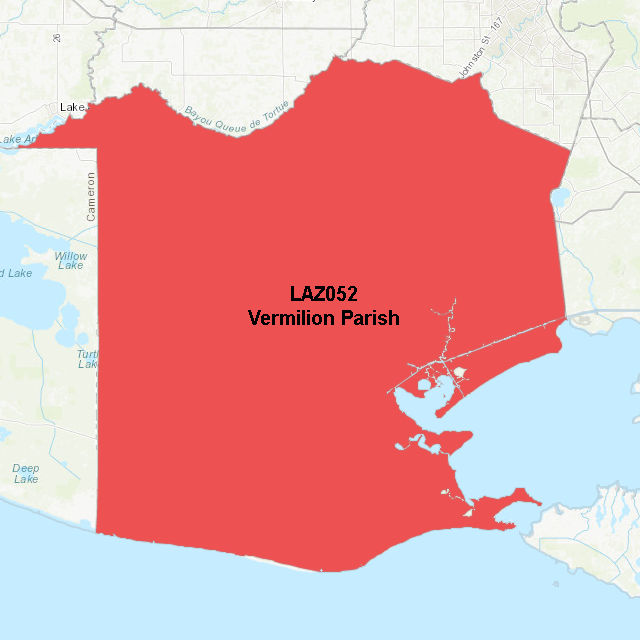
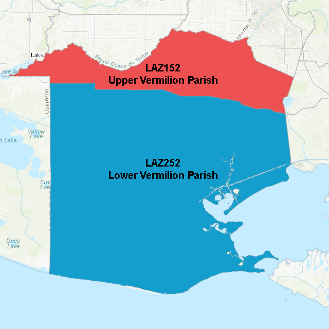
Vermilion Parish: The zone split was along Louisiana Highway 14 and created Upper Vermilion Parish and Lower Vermilion Parish.
| Vermilion Parish before change |
Vermilion Parish after change |
 |
 |
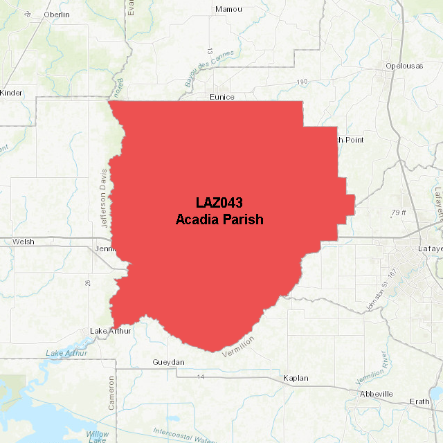
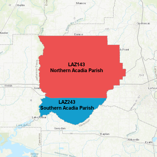
Acadia Parish: The zone split was along U.S. Highway 90 from the western parish boundary to just east of Estherwood when U.S. 90 turns northeast. From there, the split boundary runs due east to the parish line. This change created Northern Acadia Parish and Southern Acadia Parish.
| Acadia Parish before change |
Acadia Parish after change |
 |
 |
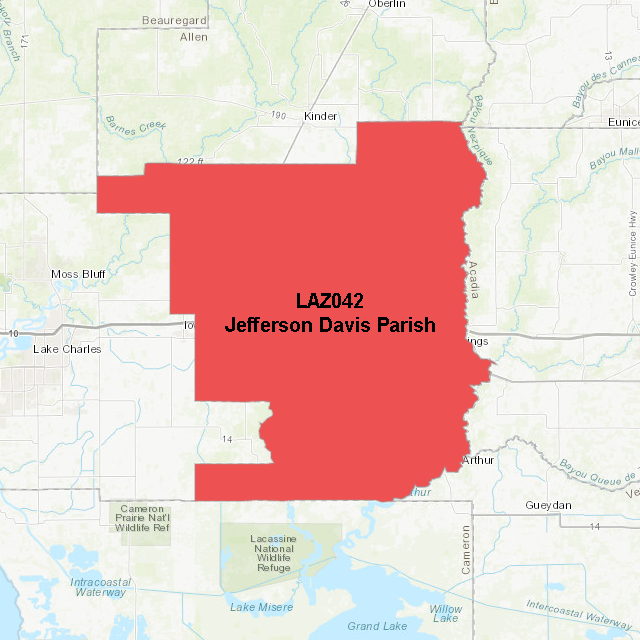
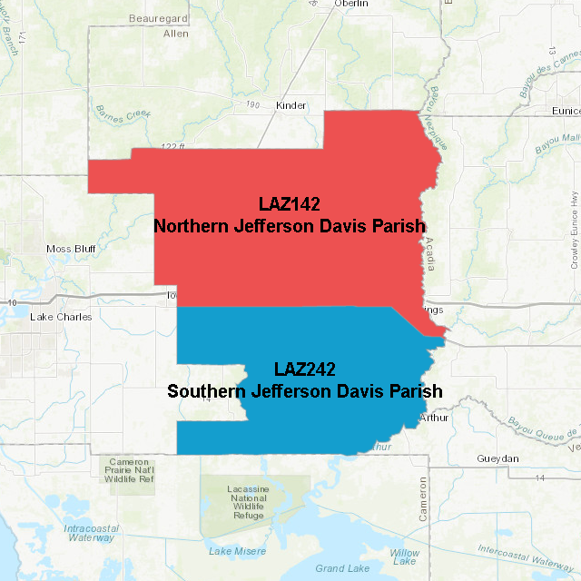
Jefferson Davis Parish: The zone split was along U.S. Highway 90 and created Northern Jefferson Davis Parish and Southern Jefferson Davis Parish.
| Jefferson Davis Parish before change |
Jefferson Davis Parish after change |
 |
 |
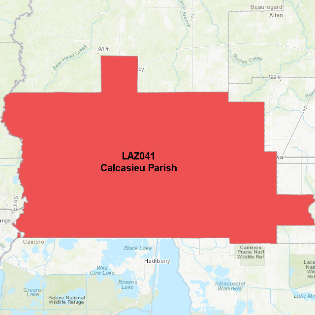
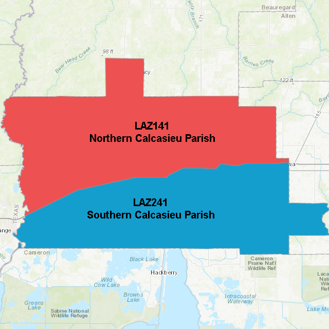
Calcasieu Parish: The zone split was along Interstate 10 and created Northern Calcasieu Parish and Southern Calcasieu Parish.
| Calcasieu Parish before change |
Calcasieu Parish after change |
 |
 |
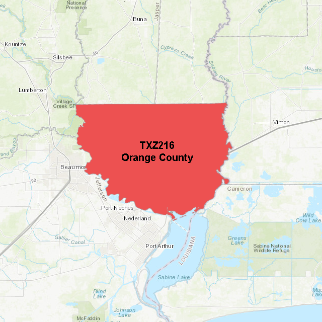
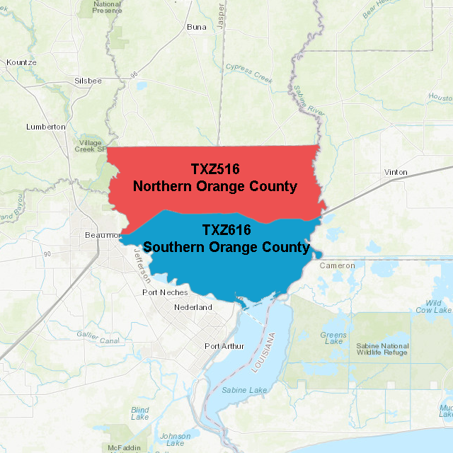
Orange County: The zone split was along Interstate 10 and created Northern Orange County and Southern Orange County.
| Orange County before change |
Orange County after change |
 |
 |
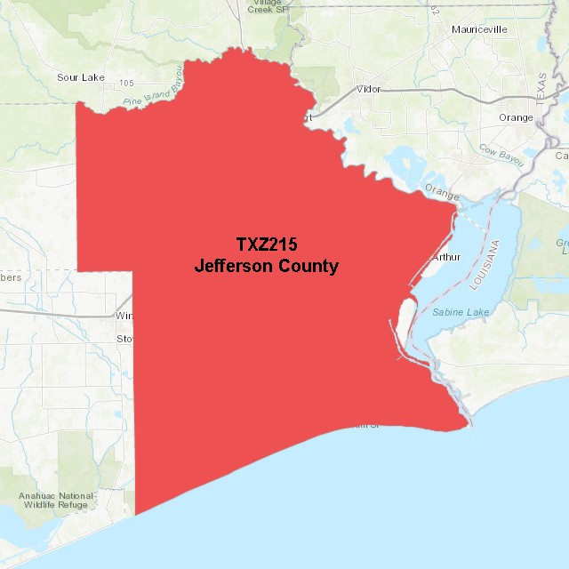
Jefferson County: The zone split was along Interstate 10 and created Upper Jefferson County and Lower Jefferson County.
| Jefferson County before change |
Jefferson County after change |
 |
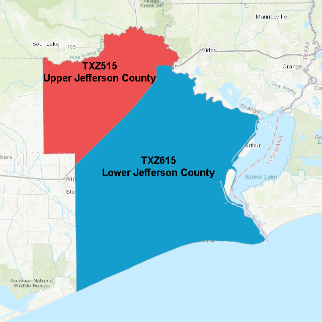 |
Table 1: Old public and fire zones and corresponding Universal Geographic Codes (UGC) for WFO Lake Charles:
UGC: Old public & fire zones and corresponding UGC for which WFO Lake Charles issued forecasts and warnings.
----------------------------------
LAZ041: Calcasieu Parish
LAZ042: Jefferson Davis Parish
LAZ043: Acadia Parish
LAZ052: Vermilion Parish
LAZ053: Iberia Parish
LAZ054: St. Mary Parish
TXZ215: Jefferson County
TXZ216: Orange County
Table 2: New public & fire zones and corresponding UGC for which WFO Lake Charles is issuing forecasts and warnings effective March 8, 2023:
UGC: New Public Zone Name
-------------------------------
LAZ141: Northern Calcasieu Parish
LAZ241: Southern Calcasieu Parish
LAZ142: Northern Jefferson Davis Parish
LAZ242: Southern Jefferson Davis Parish
LAZ143: Northern Acadia Parish
LAZ243: Southern Acadia Parish
LAZ152: Upper Vermilion Parish
LAZ252: Lower Vermilion Parish
LAZ153: Upper Iberia Parish
LAZ253: Lower Iberia Parish
LAZ154: Upper St. Mary Parish
LAZ254: Lower St. Mary Parish
TXZ515: Upper Jefferson County
TXZ615: Lower Jefferson County
TXZ516: Northern Orange County
TXZ616: Southern Orange County
Table 3: NWS products affected by the WFO Lake Charles, LA, zone changes effective March 8, 2023:
Product Name WMO Heading AWIPS ID
--------------------------- ----------- --------
Hurricane Local Statement WTUS82 KLCH HLSLCH
Tropical Cyclone Watch/Warning WTNT81 KNHC TCVAT1-5
Coastal Hazard Message WHUS42 KLCH CFWLCH
Fire Weather Forecast FNUS52 KLCH FWFLCH
Fire Weather Message WWUS82 KLCH RFWLCH
Fire Danger Statement FNUS62 KLCH RFDLCH
Zone Forecast FPUS52 KLCH ZFPLCH
Point Forecast Matrices FOUS52 KLCH PFMLCH
Tabular State Forecast FPUS62 KLCH SFTLCH
Tsunami Message WEXX20 PAAQ TSUAT1
Public Information Statement NOUS42 KLCH PNSLCH
Non-Precipitation Watch/Warning/ WWUS72 KLCH NPWLCH
Advisory
Flood Watch WGUS62 KLCH FFALCH
Special Weather Statement WWUS82 KLCH SPSLCH
Winter Weather Message WWUS42 KLCH WSWLCH
Area Forecast Discussion FXUS62 KLCH AFDLCH
Hydrologic Outlook FGUS72 KLCH ESFLCH
Hazardous Weather Outlook FLUS42 KLCH HWOLCH
NWS partners and users should take the appropriate action to ensure systems recognize the new UGC (Z) and new zone alignments and names.
Shapefiles for public and fire weather forecast zones are available online at:
https://www.weather.gov/gis/PublicZones
https://www.weather.gov/gis/FireZones
A written and graphical depiction of this change is available online at:
https://www.weather.gov/lch/2023PublicZoneChange
For more information, please contact:
Roger Erickson
Meteorologist-In-Charge
NWS Lake Charles, LA
roger.erickson@noaa.gov
337-477-5285 x222
or
Melinda Bailey
NWS Southern Region Headquarters
Fort Worth, TX
melinda.bailey@noaa.gov
904-741-4470 x223
National Service Change Notice 22-121 is available at:
https://www.weather.gov/media/notification/pdf2/scn22-121_public_fire_lch.pdf
|


