National Weather Service United States Department of Commerce

Remnants of Arthur and Heavy Rainfall Across the South; Severe Weather for the East

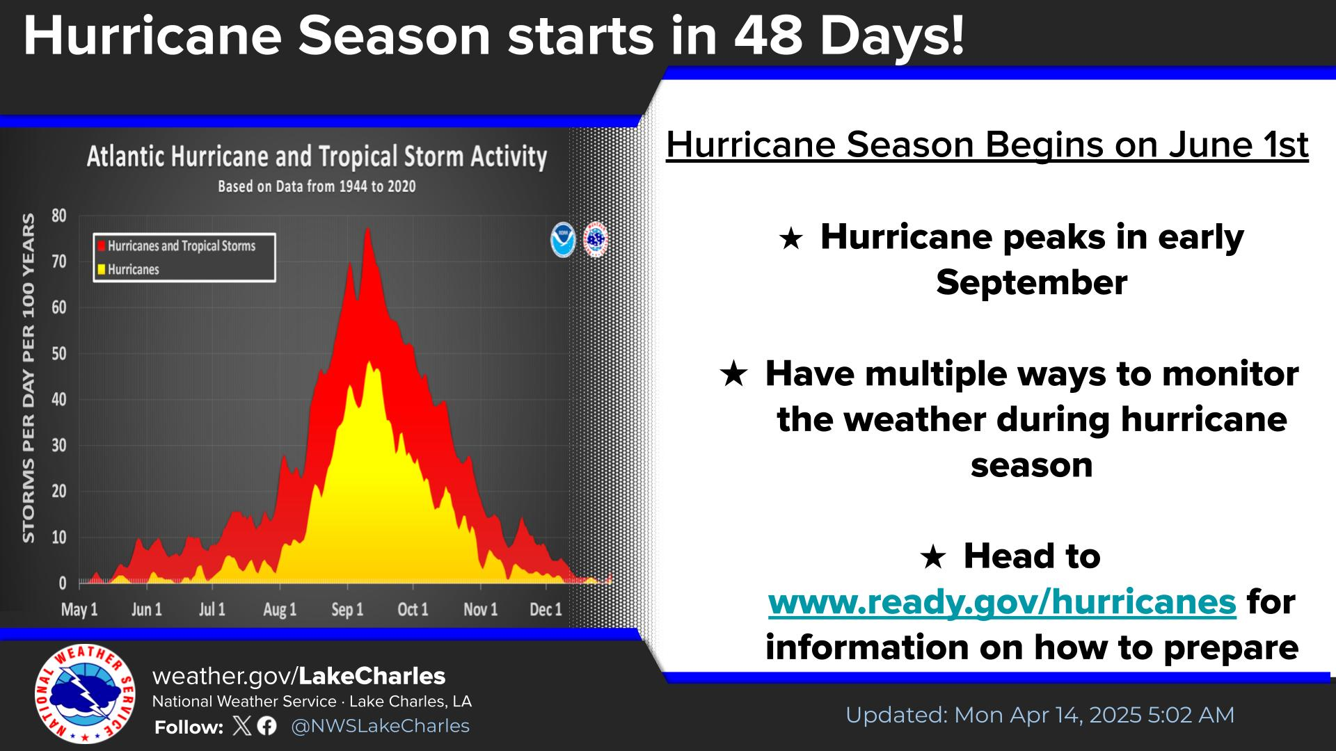
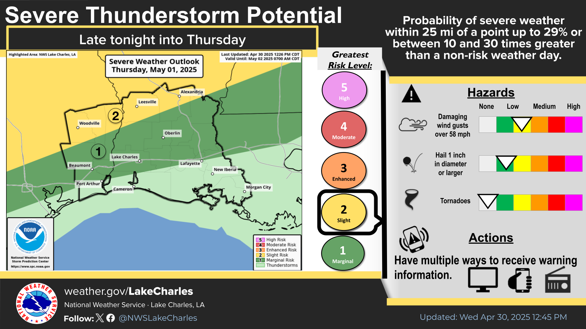
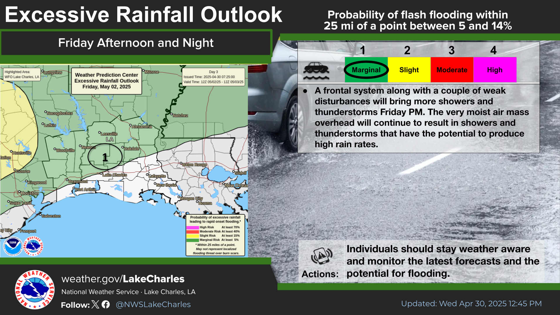
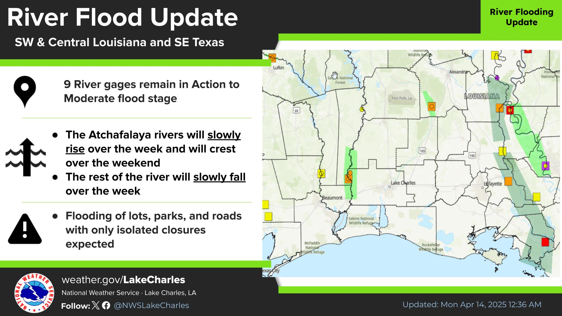
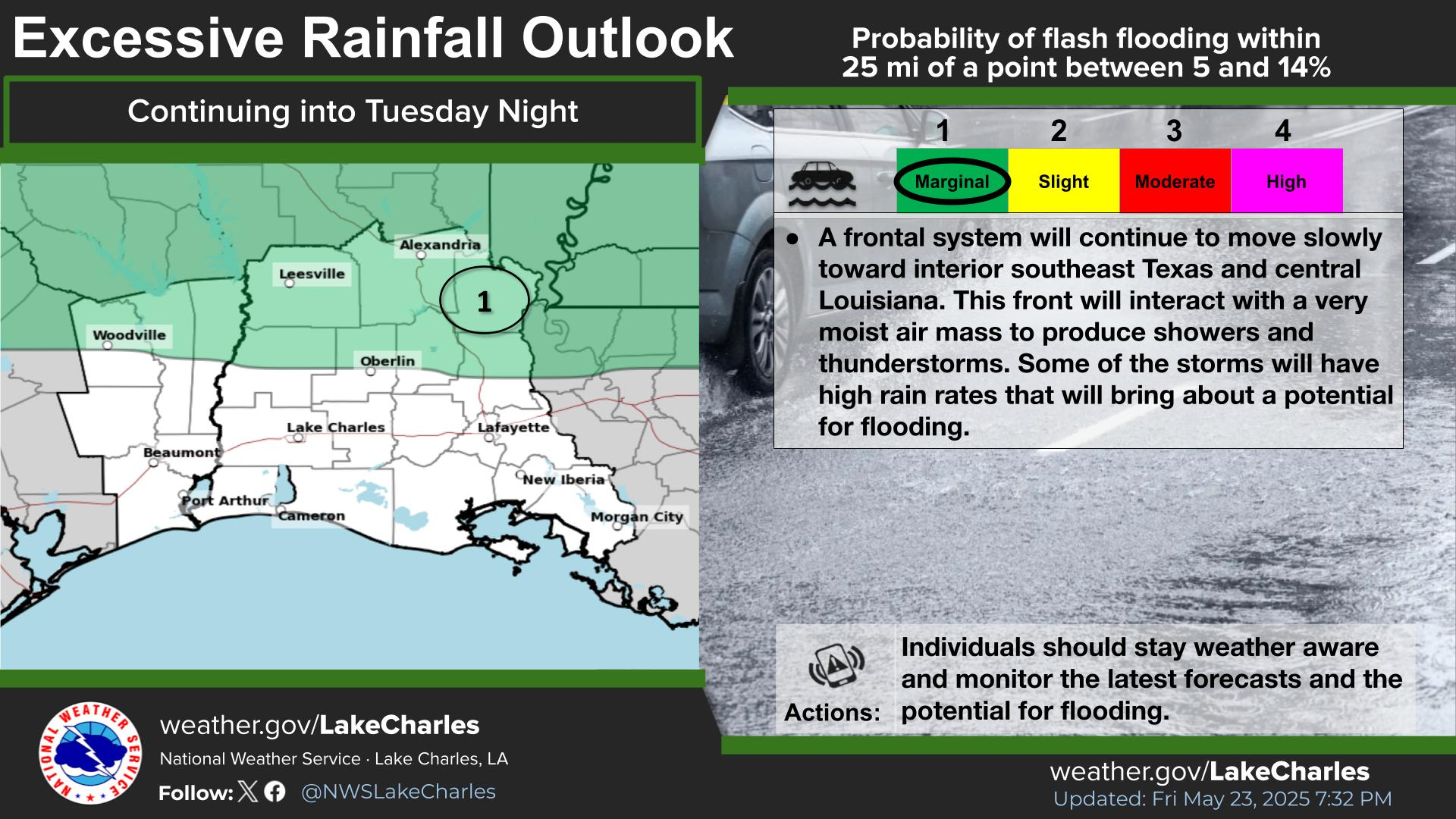
Potential life threatening flash flooding across the northern Gulf Coast states as the remnants of Arthur track across the area. Remember, turn around - don't drown. In addition, severe thunderstorms with tornadoes are possible with the circulation of this storm. The threat for more severe thunderstorms will occur across portions of the Northeast, mid-Atlantic and central Appalachian's. Read More >

The remnants of Arthur continue to produce catastrophic flooding across Avoyelles parish this afternoon. A Flood Watch remains in effect for central Louisiana until this evening. A Heat Advisory is in effect for southeast Texas until this evening with another heat advisory in effect for southwest Texas and Southwest Louisiana Friday. A Wind Advisory is in effect generally along and south of the I-10 corridor until this evening. Drier conditions expected Friday ahead of another round of storms Saturday as an upper level low moves across the region Fathers day is shaping up to be dry, but hot.
Periods of heavy rainfall are possible this afternoon as the remnants of Arthur continue to gradually lift northeast. Additional rainfall amounts up to 6 inches are possible, especially across parts of central Louisiana
A Wind Advisory is in effect through this evening generally along and south of the I-10 corridor for south winds of 10 to 20 mph with gusts to 30 mph.
Winds and seas will remain elevated through tonight over the coastal lakes and bays and Gulf waters.
Less rain and cloud cover along with warmer temperatures and high relative humidity will result in hazardous heat across southeast Texas today.
Dewpoints in the upper 70s to lower 80s will produce heat index values of 108-112 Friday afternoon

Latest Text Product Selector
 
 
Hourly Weather Roundup ( )
Location Sky/Weather Temp Dewpt RH Wind Baro Remarks
Lake Charles
N/A
N/A
N/A
N/A
N/A
N/A
N/A
Abbeville
N/A
N/A
N/A
N/A
N/A
N/A
N/A
Alexandria
N/A
N/A
N/A
N/A
N/A
N/A
N/A
Beaumont
N/A
N/A
N/A
N/A
N/A
N/A
N/A
De Quincy
N/A
N/A
N/A
N/A
N/A
N/A
N/A
De Ridder
N/A
N/A
N/A
N/A
N/A
N/A
N/A
Fort Polk
N/A
N/A
N/A
N/A
N/A
N/A
N/A
Jasper
N/A
N/A
N/A
N/A
N/A
N/A
N/A
Jennings
N/A
N/A
N/A
N/A
N/A
N/A
N/A
Lafayette
N/A
N/A
N/A
N/A
N/A
N/A
N/A
Nederland/Port Arthur
N/A
N/A
N/A
N/A
N/A
N/A
N/A
New Iberia
N/A
N/A
N/A
N/A
N/A
N/A
N/A
Oakdale
N/A
N/A
N/A
N/A
N/A
N/A
N/A
Opelousas
N/A
N/A
N/A
N/A
N/A
N/A
N/A
Orange
N/A
N/A
N/A
N/A
N/A
N/A
N/A
Patterson
N/A
N/A
N/A
N/A
N/A
N/A
N/A
Pineville
N/A
N/A
N/A
N/A
N/A
N/A
N/A
Sulphur/Carlyss
N/A
N/A
N/A
N/A
N/A
N/A
N/A
"N/A" or "MISG" will be displayed if values are not available. In the LOCATION column, click on links for a list of recent observations at sites of interest. In the WIND column, VRB is "variable" and G is "gust". Wind speeds are in MPH. In the BARO (pressure) column, values are in inches. In the REMARKS column, HX is "heat index", WCI is "wind chill index", and VSB is "visibility" (if shown).
 

Current Weather
 
Rivers & Lakes
 
Forecast Maps
 
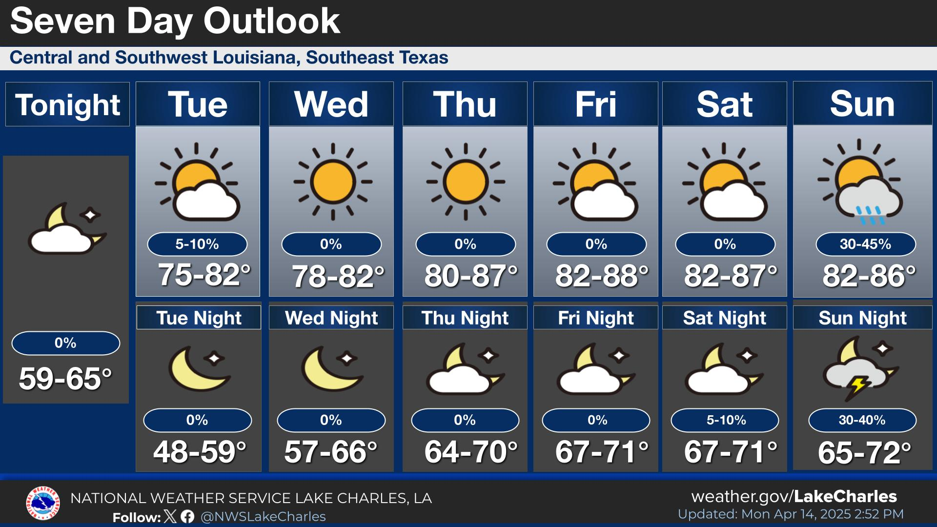
Hour By Hour Forecast
 
Tropical Weather
 
Marine Forecast
 
Text Bulletins
 
Forecast Discussion
 
NOAA Weather Radio
 
Submit Storm Report