Heat Wave Persists Over the Central U.S.; Significant Flooding Expected in the Northern Mid-Atlantic Tuesday
Dangerous and extreme heat will remain across portions of the Central U.S. this week, persisting across the Mid to Lower Mississippi Valleys, Gulf Coast, Southern Plains and portions of Texas. A heat wave over the Southwest will intensify late this week. Severe thunderstorms and flash flooding will spread from the Great Lakes/Ohio Valley to the Mid-Atlantic and Northeast the next few days.
Read More >
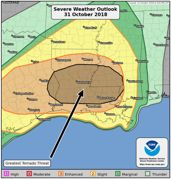
A strong cold front moved across the Lower Mississippi River Valley during the late evening of October 31st through the early morning of November 1st. This produced widespread severe thunderstorms and numerous tornadoes from Texas to Mississippi in one of the largest tornado days of 2018.
A total of 18 tornadoes, 3 of which were strong, occurred within the Lake Charles County Warning area. There were likely additional tornadoes which occurred but could not be confirmed by NWS survey teams. This was one of the largest tornado outbreaks recorded across southeast Texas and southwest Louisiana.
Tornado List
Meteorological Analysis
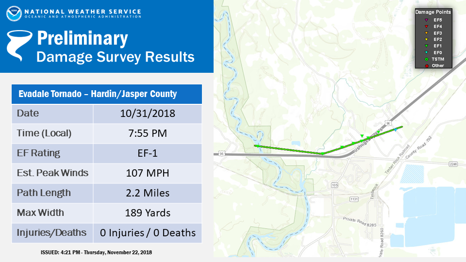
Evadale Tornado
A tornado started just west of the Neches river and moved east for a time just north of HWY 96. The
tornado moved slightly northeast damaging several roofs of homes and blowing out the walls of a metal building. Several
trees were also snapped along the path. The tornado crossed HWY 96 north of Evadale and ended near county road 847.
Buna Tornado #1
A weak tornado briefly touched down south of Buna along county road 784 producing minor
tree damage.
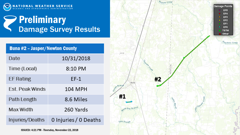
Buna Tornado #2
A tornado started along FM 253 causing roof damage to one home. The tornado then moved through a remote area
causing tree damage for several miles to the northeast before ending near HWY 87.
West Bundick Tornado
A tornado snapped several trees along Chester Davis Road,
northeast to Lumas Road.
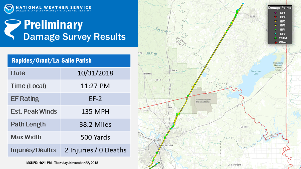
Rapides/Grant/La Salle Parish Tornado
A long-track tornado started near Hwy 165 south of Alexandria, where
trees were snapped along the west side of the highway. The storm crossed Hwy 165
and hit near the Horseshoe Drive region, where several more trees fell, including
some on homes. The storm removed the roof of a restaurant on MacArthur Drive,
and several other businesses had roof damage as well. Behind the mall, a bowling
alley had a wall collapse. Significant roof damage occurred to several businesses
in the Lee Street/Overton Street region. The tornado crossed the Red River, and
moved from the south side of Highway 167 to the north side of Highway 167 in
Pineville. Numerous trees and power lines were downed on the campus of Louisiana
College and surrounding areas. Some of these trees did land on homes and vehicles.
As the tornado continued north-northeast, it snapped more trees and power lines
in the Kingsville region, including Donahue Ferry Road, Pearce Road, Pinecrest,
and Camp Beauregard. East of the Ball-Paradise region, many large trees were
downed along Washboard Road, damaging some homes and buildings. This tornado
continued into Grant Parish, where it destroyed a mobile home. It was lifted out
of the ground and flipped, moving approximately 20 yards. Two of the family
members in the mobile home suffered minor injuries and the remainder were uninjured. The iron frame
of the mobile home was ripped off and thrown a couple hundred yards. In LaSalle
Parish, approximately 100 structures were damaged. The worst damage was focused
near the town of Trout on Mayo Road and Cecil Road. On Cecil Road, a double-wide
mobile home on cinder blocks was lifted, flipped, and moved approximately 100
yards. The couple living in the home received the tornado warning via Wireless
Emergency Alerts and moved to a nearby home before the mobile home was destroyed.
This is a true testament to the effectiveness of WEAs and how they save lives.
On Mayo Road, a mobile home was completely destroyed with 5 other mobile homes,
3 structures, and 4 family homes suffering partial damage. The tornado moved
northeast along Highway 772, where the roof of a mobile home was partially ripped
off. The tornado moved through the community of Trout, where additional trees were
snapped or uprooted along Highway 84 and Church Street. It continued northeast
across Biltmore Drive, and across a heavily wooded area before lifting near an
unnamed dirt road just off of Highway 127 a couple of miles northwest of Jena.
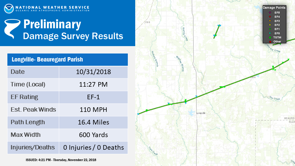
Longville Tornado
A tornado formed north of LA 110 west of Longville
and moved northeast across Cook McCoy Road where it damaged trees
and outbuildings. The tornado crossed Wesley Coleman Road and
paralleled Brittney Lane snapping trees and power poles in
addition to damaging outbuildings. The tornado reached its maximum
width near Keller Road where it snapped numerous pine trees. The
tornado continued northeast crossing US 171 south of Memorial
Church road. The tornado continued northeastward through rural
parts of Beauregard Parish. The tornado crossed Greentown Road
where it snapped trees and caused damage to part of a house. The
tornado dissipated near LA 391 northwest of Dry Creek.
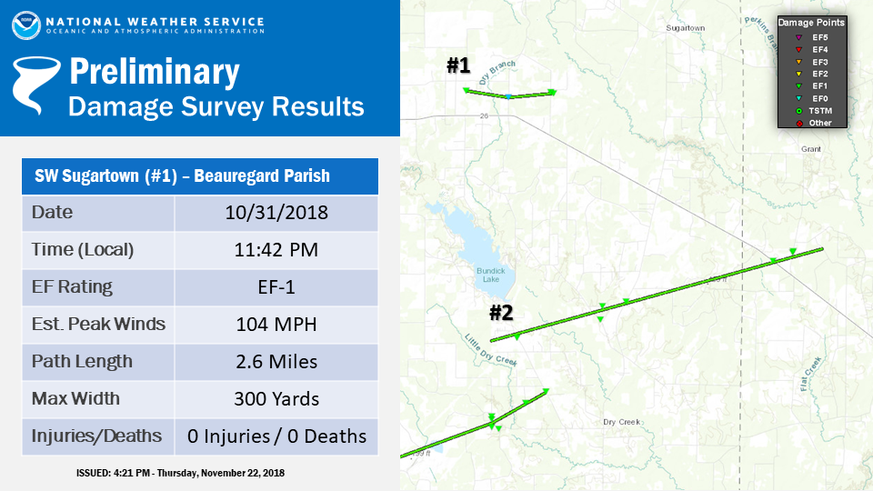
Southwest Sugartown Tornado
A tornado started east of Rutherford Road, and moved
across Vaughn Road, ending near Smyrna Road. Several trees were snapped.
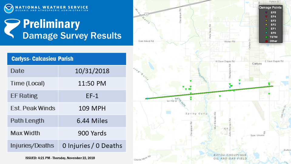
Carlyss Tornado
A tornado began near Shelby Lane north of HWY 108.
The tornado continued east northeast for several miles
crossing Choupique road, Thompson road, and Johnny Jones roads before ending around HWY 27. Damage was mostly caused
by snapped trees, however a few roofs were torn off and with several RV`s overturned and metal sheds blown over.
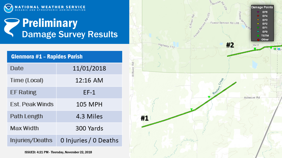
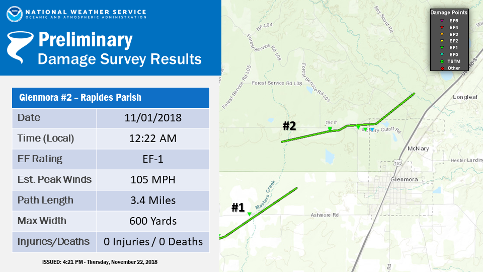
Glenmora Tornado #1
A tornado began in the woods near Hwy 462, moving east-northeast.
Several trees were blown down or snapped along East River Road and Ashmore Road.
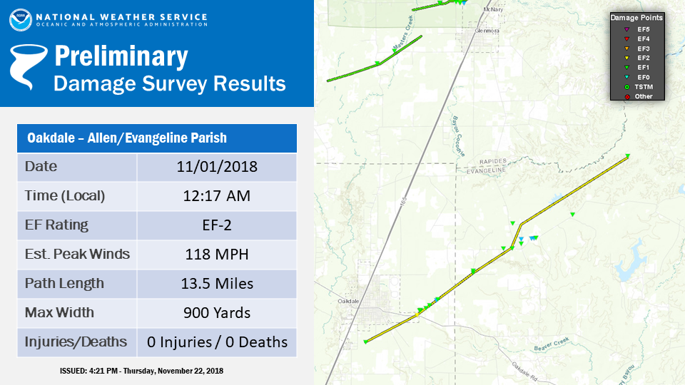
Oakdale/Turkey Creek Tornado
A strong tornado started south of Highway 10, and as it crossed
the highway it snapped several power poles. The tornado then moved down Cypress
Creek Road, where it snapped numerous trees and power lines. In Evangeline Parish,
it moved from Cypress Creek Road to Cypress Road and Red Lick Road, before
dissipating south of the Rapides Parish line. Many trees and power lines were down.
Glenmora Tornado #2
Another tornado formed in the rural areas west of Glenmora, moving northeast.
Numerous trees and power lines were downed along Hwy 113.
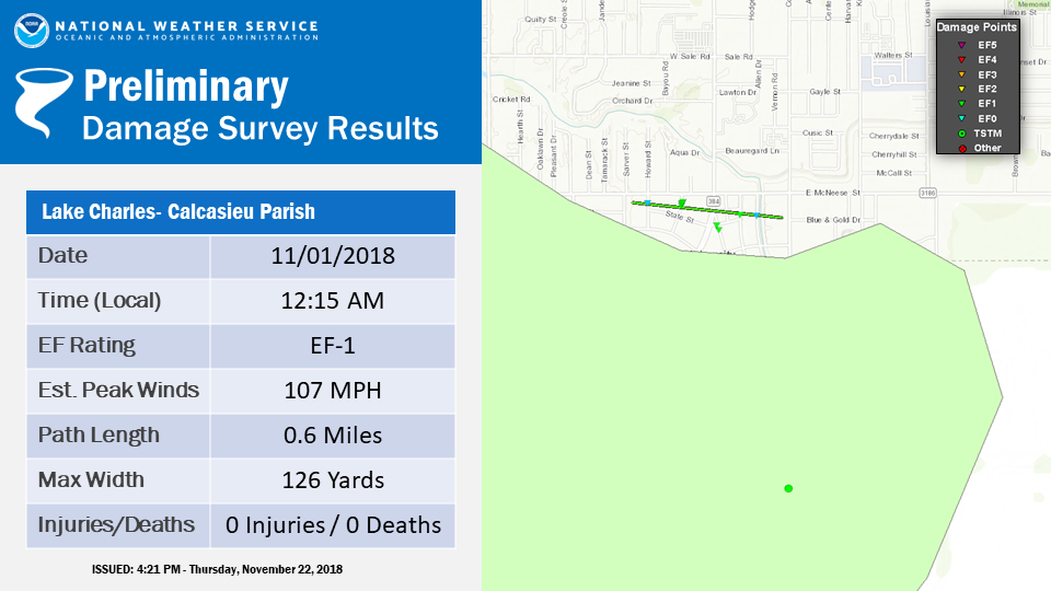
Lake Charles Tornado and Wind Damage
A large area of damaging winds occurred over south Lake Charles causing sporadic damage between I-210 and
Gauthier Road. A ship docked along the Calcasieu River recorded an 80 MPH gust with this area of damaging winds. In addition, a brief tornado touched down just south of the McNeese university causing damage to trees, roofs and carports.
The old Kroger store also sustained damage.
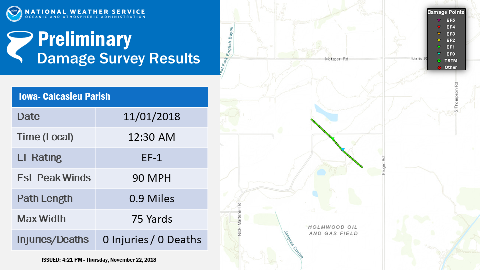
Iowa Tornado
A weak tornado formed north of Nick Martone Road
and moved to the southeast. The tornado crossed Nick Martone Road
where it damaged two outbuildings. The tornado then dissipated in
a field south of Nick Martone Road.
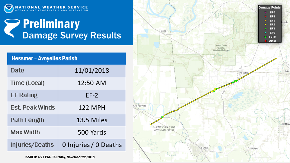
Hessmer Tornado
The tornado started near US Highway 71 near Cheneyville, snapping
several power poles. As it moved northeast, it blew down many trees and power lines.
The most significant damage was to a new home on Bordelon Road, built of steel beams
and metal sheets. A large roll up door was blown in, and picked up an outside AC unit,
tossing it into the garage. The steel beams were bent in three-fourths of the building.
Half of the metal roof was blown off, and what remained shifted several inches. One
exterior wall shifted several inches. Several other homes on Bordelon Street had part
of their roofs removed. Many trees were snapped and power lines were downed. Tree
damage was noted on Highway 115 south of Hessmer, and the tornado dissipated before
it reached Highway 1 in Mansura.
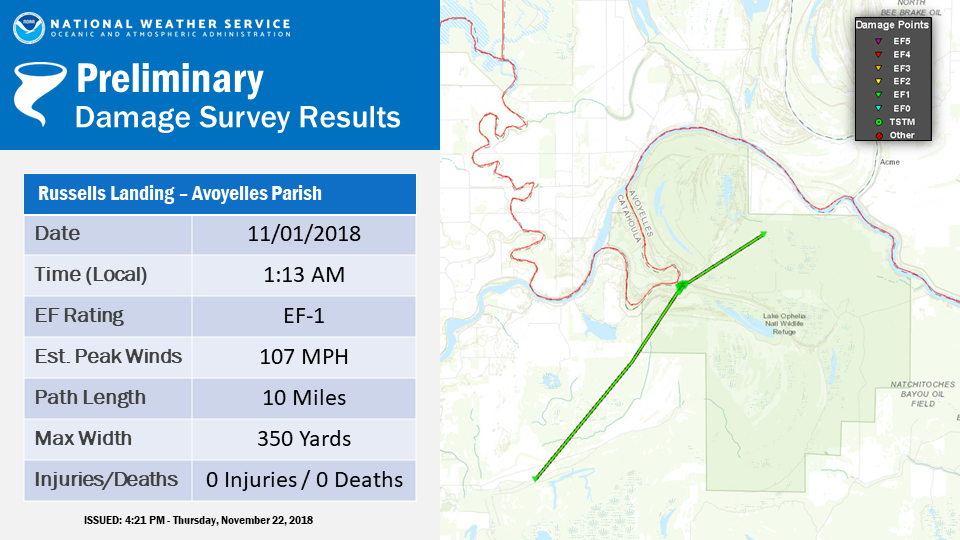
Russells Landing Tornado
A tornado started in remote areas east of Marksville, and moved across
Lake Ophelia Wildlife Refuge, where numerous trees were blown down or snapped. At
Russells Landing, many trees were blown down or snapped. One landed on an RV. The
tornado dissipated northeast of that region in the wildlife refuge.
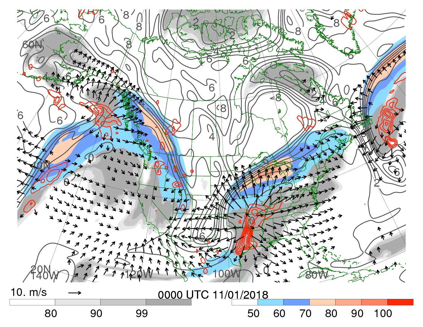
An upper level trough moved southeastward into the Southern Plains during the afternoon of 31 October. The
colocation of the poleward exit region and the equatorward entrance region of two jet streaks at 250 hPa contributed to upper level divergence
which supported ascent and the subsequent deepening of the surface cyclone over the Arklatex region.
250-hPa wind speed (m s-1, shaded according to color bar), 250-hPa potential vorticity (gray contours every 1 PVU),
250-hPa relative humidity (%, shaded according to gray scale), 600–400-hPa layer averaged ascent (red contours every 5 x 10⁻³ hPa s-1, negative values only),
300–200-hPa layer averaged irrotational wind (vectors starting at 3 m s-1). GFS analysis courtesy of Dr. Heather Archambault.
Southerly winds east of the surface cyclone resulted in a moist airmass being adevected into the region with dewpoints reaching
the lower 70s. This low level moisture coupled with surface temperatures in the mid to upper 70s and conditionally unstable lapse rates resulted in MLCAPE
of 1000-2000 J/kg across the Lower Mississippi River Valley. The strengthening low level wind fields also contributed to over 40 knots of 0-6 km bulk wind shear.
This combination of instability and wind shear resulted in an environment conducive for the development of severe thunderstorms, including supercells.
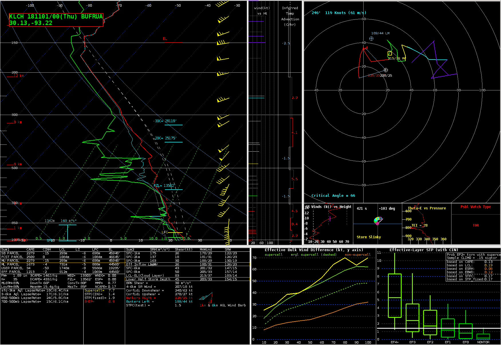
01 November 2018 00Z KLCH Sounding
The veering low level winds and increasing wind speeds resulted in low level helicity exceeding 150 m2/s2 as measured by the 00Z KLCH sounding.
The sounding also indicated LCL heights less than 1000 m due to the abundant low level moisture. Numerous research studies have found that these values of helicity and
LCL heights are associated with environments conducive to the development of tornadoes.
An area of multicellular convection developed near Houston during the afternoon hours of 31 October. As this area of convection moved northeastward, the
environment became increasingly supportive of severe thunderstorms and the convection became more supercellular in structure. This supercell produced at least 5 tornadoes
across Southeast Texas and portions of Louisiana. The strongest of the tornadoes developed just southeast of Alexandria around 11:30 PM and continued northeastward during the next hour,
covering a distance of over 35 miles. By this time, low level helicity across much of Louisiana had increased to 300 m2/s2. This environment supported the development of numerous QLCS
tornadoes as the line of thunderstorms along the cold front moved eastward during the overnight hours of 1 November. A total of 18 tornadoes were confirmed by NWS storm surveys. However,
there were several additional Tornadic Debris Signatures observed in KLCH and KPOE radar data which occurred in areas where ground teams were unable to survey. Therefore, the actual number
of tornadoes which occurred in the Lake Charles CWA on 31 October-1 November 2018 was likely even greater.


