Life-threatening and locally catastrophic flash and urban flooding is expected across portions of south-central Texas through early Friday, with significant river flooding and rapid rises on small streams, arroyos, and typically dry washes expected. A significant heat wave continues for the Rockies, Northern Plains, and Great Lakes into the Mid-Atlantic, peaking in intensity through midweek. Read More >
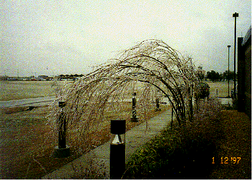
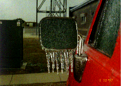
ICE STORM 1997Mark David Roth* About the Lake Charles County Warning Area (CWA) Lake Charles is located in extreme southwestern Louisiana, about 30 miles east of the Sabine River which divides the states of Louisiana and Texas. Being at a latitude of 30 degrees north and near the coast of the Gulf of America, significant winter precipitation events are uncommon along the coast, but become more common in central and northern sections of the state. Extreme winter events such as blizzards are virtually unknown to almost everyone in the area. This makes any accumulation of snow, sleet, or freezing rain a major hazard, as snowplows and other de-icing equipment are nowhere to be found throughout Louisiana and the public has little experience with wintery situations. Effects of the Ice Storm A quarter inch of ice accumulated primarily on grassy and non-paved surfaces, with an inch accumulating on higher, more exposed surfaces such as trees and power lines. This storm left around 3/4 of the area between Beaumont, TX and Lake Charles, LA powerless. Power outages were noted at far west as Houston and Galveston, in some cases for as many as 5 days. Synoptic Situation The first few days of January were uncharacteristically warm, due to a warm subtropical airmass dominating the area. On the 5th, an arctic front surged through the Lake Charles CWA, leading to a period of below normal temperatures and a cold rain on the 7th and 8th. This caused soil and surface temperatures during the period to quickly cool down into the 40s (around 7 degrees C). Meanwhile, a second blast of arctic air moved south from Canada, passing through the forecast area during the afternoon of the 10th. As the cold front sagged south to a Brownsville/ Miami line, a surface low began to form along the then stationary front east of the city of Brownsville, which eventually led to a stationary overrunning situation across the region. The forecast models, beginning with the MRF on the 7th and ending with the ETA on the 11th (which was much too dry, even during the frozen rain) hinted at a frozen precipitation event sometime between the 11th and 13th. Forecaster concern about a possible ice storm started to be addressed early on the 9th on area forecast discussions (AFDs) from Lake Charles and Slidell and became a near certainty by the 10th. Around midnight on the 12th, a narrow streak of snow formed near Port Arthur and moved east-northeast near 60 mph across the area, being moved at such high rate of speed by the winds at mid levels of the atmosphere (500-700 hPa). Lake Charles reported snow between midnight and 2 am. By early morning on the 12th, a large area of freezing rain and sleet filled in much of Southeast Texas, from College Station east and southward. This was in response to a 700 hPa shortwave moving east across Central Texas and to the normal diurnal development of precipitation induced by cooling aloft during predawn hours in cloudy situations. The leading edge of the freezing rain and sleet reached Lake Charles by 9 am and the frozen precipitation continued through the evening of the 13th before finally ending after the final in a series of several shortwaves passed by. The antecedent conditions leading up to this event on the sounding from the morning of the 11th were a fairly strong temperature inversion just above 900 hPa (39 degrees F/4 degrees C) and a precipitable water of only 0.31" (8 mm). When the precipitation finally developed, the sounding "wet bulbed" below 700 hPa to around freezing, causing the initial snow flurries around midnight. As the inversion continued to warm during the morning of the 11th, sleet was briefly the dominant form of precipitation before changing to freezing rain later in the day. The initial sleet dropped the temperature instantly to freezing; temperatures during the event never fell below 30 degrees at Lake Charles (-1 degrees C) and 27 degrees at Alexandria (-3 degrees C), nor did they rise above 32 degrees (0 degrees C). On the 13th, it was apparent even at the automated sites that significant ice accumulations were present. Wind gages at Galveston, Houston, Sea Rim State Park, Beaumont, and Lake Charles reported calm winds, despite northeast winds at 15 mph! Technicians had to run across the runway and chip ice off the Lake Charles anemometer. The following are a couple pictures taken around the office during the storm- click for a larger image.
It took weeks to remove all the downed tree limbs that fell during the ice storm. In fact, for the next few months afterward, the office had to be careful about reports from the public about falling branches during thunderstorms possibly triggering severe thunderstorm warnings and altering the area's severe weather climatology! Another unexpected side effect of the Ice Storm has occurred as of late: an areawide baby boom! Admissions at local hospitals have been 150% normal during August, September, and October of 1997. One expectant mother was quoted by the Lake Charles American Press newspaper on October 11th as saying "everywhere I looked, there was a pregnant woman." Several million dollars of damage occurred across the area due to the Ice Storm. Much experience was gained by those on duty at the weather office during the event and by residents of the region about how disruptive an ice storm can be. Author's Current Affiliation: * NWS's National Centers for Environmental Prediction - Hydrometeorological Prediction Center, Camp Springs MD |
||