|
|
2008:
WEATHER OF WEST TEXAS
|
|
| Flooding at Charles Guy Park in Lubbock - 12 September 2008 |
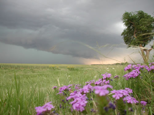
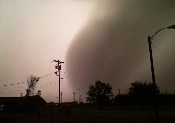
Storm moving into the Dickens area - 27 May 2008 |
|
The year of 2008 started out on the dry side, and when coupled with a relatively dry end of 2007, it heightened potential drought concerns. By mid April, severe drought (categorized as D2 on the drought monitor) was observed over the southwest South Plains. However, the drought conditions were relatively short-lived, with a potent storm system bringing much needed rain to the region in early May. Periodic rainfall then continued on through the summer months, with relative maximums in precipitation during the second half of June, mid-July and mid-August. The relatively consistent rainfall was punctuated by a record setting rainfall in mid-September, when 7.80 inches of rain fell in Lubbock over a 24-hour period on the 11th and 12th. One more widespread rain event impacted West Texas in mid-October before dry conditions returned to the region to close out the year.
Temperatures through 2008 fluctuated around the average, with the greatest variability during the cool season (as is typical). The exception was one stretch from late May into the first half of June when readings were consistently above average. The hot stretch subsided as rounds of showers and thunderstorms affected the region during the second half of June.
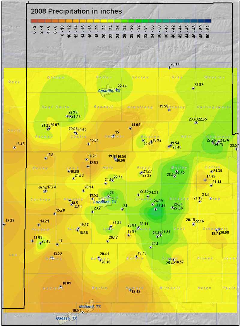
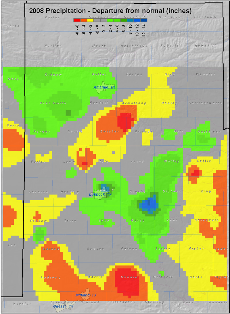
For the year, above average rainfall fell across the southwest Texas Panhandle, as well as from the central South Plains through the western Rolling Plains northeastward through the Childress area (see the maps below). Elsewhere, yearly rainfall totals were near or slightly below normal from much of the western South Plains, eastern Rolling Plains, south central Texas Panhandle and northern South Plains. The above average swath of rainfall from Lubbock east and northeast through the Childress area was primarily due to a very wet stretch in mid-September when Lubbock set its all-time 24-hour rainfall record. The relative bulls-eye in moisture across the southwest Texas Panhandle was aided greatly by a wet stretch in the middle of August when this area recorded 5 to 8 inches of rain. Overall, the region experienced a relatively moist middle part of the year, with a dry beginning and end.
|
|
|
|
This map displays the 2008 year precipitation totals. The map was created with data gathered from the NWS Cooperative observers and the West Texas Mesonet. Click on the map to view a full-sized version.
|
|
|
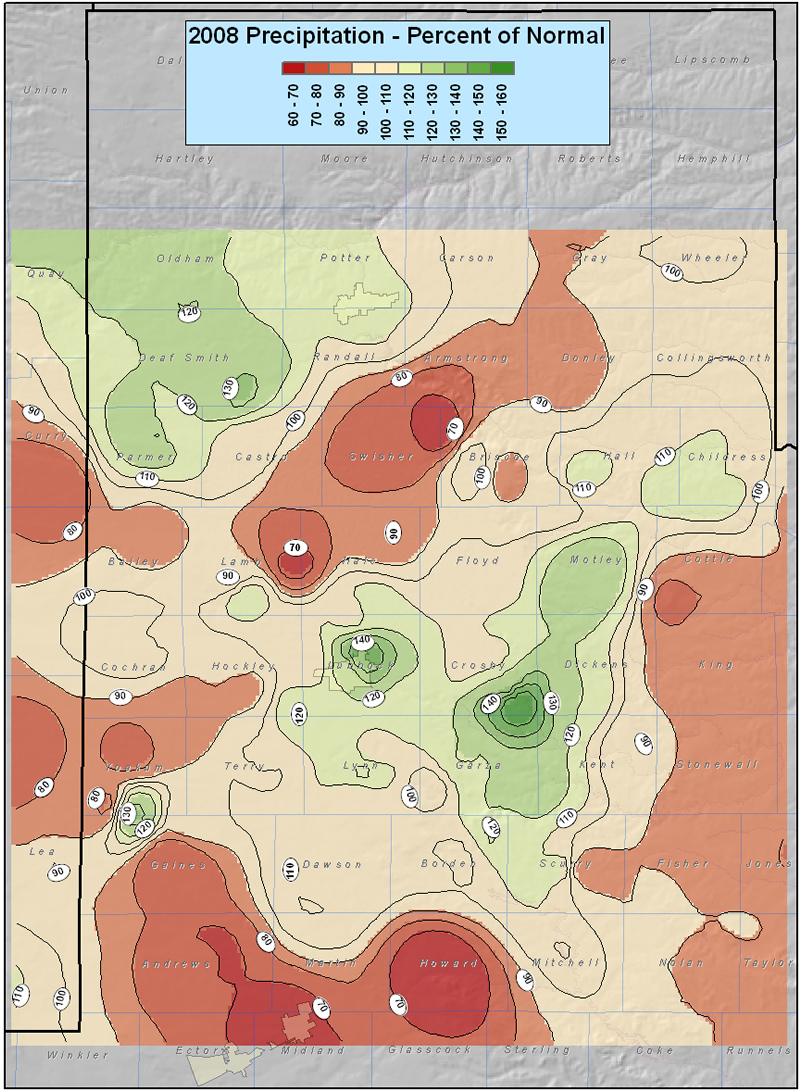
| This map shows the 2008 rainfall as a percent of the 30-year normal rainfall (1971-2000). Please click on the map to view a full-sized version. If you would like to see the precipitation as a departure from normal please click here. |
Below are some statistics from 2008 for Lubbock:
Lubbock recorded a 24-hour record rainfall when 7.80 inches fell 11-12 September. The extreme rainfall broke the previous record of 5.82 inches, set on 18-19 October 1983. A all-time calendar day rainfall record was also set with 7.46 inches falling on the 11th. This one day total broke the previous record of 5.70 inches, set on 1 June 1967.
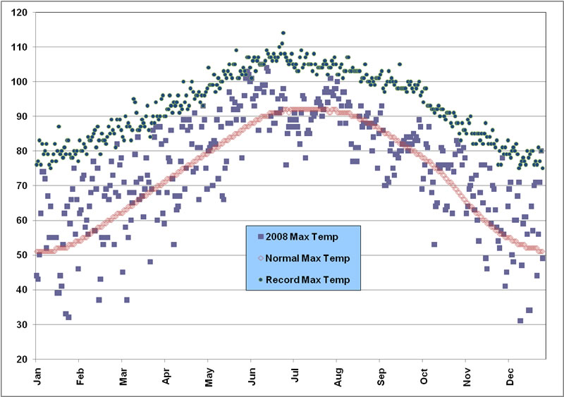
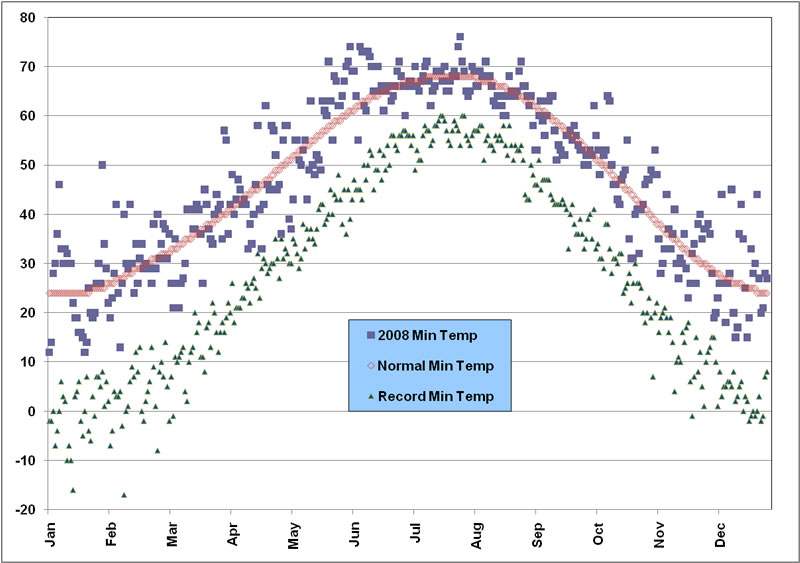
Lubbock recorded ten 100 degree days in 2008, five of which occurred successively from 31 May - 4 June. The highest temperature of the year was 105 degrees, recorded on 11 June. On the other extreme, the coldest temperature recorded for the year was 12 degrees, on both the 1st and 19th of January. Additionally, three record highs were set or tied in 2008: 93 degrees on 30 April (tie), 105 degrees on 11 June (tie), and 80 degrees on 30 December. No record lows were observed through the year. The following chart shows the monthly summary of temperature and precipitation at the Lubbock Airport.
|
LUBBOCK
|
Average High
|
Average Low
|
Precip (inches)
|
|
January
|
55.5
|
25.4
|
0.07
|
|
February
|
64.2
|
30.5
|
0.72
|
|
March
|
69.1
|
36.4
|
0.10
|
|
April
|
76.3
|
45.1
|
1.07
|
|
May
|
84.5
|
55.9
|
5.32
|
|
June
|
94.4
|
66.9
|
2.91
|
|
July
|
90.6
|
67.9
|
1.77
|
|
August
|
89.3
|
65.8
|
3.48
|
|
September
|
80.8
|
56.6
|
8.70
|
|
October
|
75.1
|
47.5
|
3.77
|
|
November
|
66.4
|
35.8
|
0.08
|
|
December
|
57.5
|
27.7
|
0.01
|
|
Annual
|
75.4
|
46.8
|
28.00
|
|
Normal
|
73.2
|
46.2
|
18.69
|
|
Departure
|
+2.2
|
+0.6
|
+9.31
|
The two graphs below show the daily high and low temperature distribution throughout the year at the Lubbock Airport. Temperatures were generally variable around the average, with the exception of late May and early June when readings were consistently above normal. The heat was maximized during a five day stretch from 31 May through 4 June when readings topped out at 100 to 103 degrees.
|
|
| Plot of the maximum (top) and minimum temperatures (bottom) observed at the Lubbock airport in 2008. Also plotted are the respective normals and records for each date. Units are in degrees Fahrenheit. Click on the images for a larger view. |
|
|
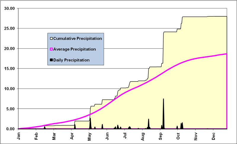
The graph below shows the yearly distribution of precipitation for 2008. After a dry start to the year, a few sporadic rain events jumped yearly totals above average by May. Numerous rain events then kept Lubbock above average through the summer. The capper was a record rainfall in mid-September which skyrocketed the year total over 10 inches above normal. However, the year ended on a dry spell with little precipitation from mid-October on.
|
|
| Plot of the cumulative and daily precipitation (in inches) recorded at the Lubbock airport in 2008. Also plotted is the 30-year average precipitation. Click on the image for a larger view. |
|
|
2008 TORNADOES AND OTHER SEVERE WEATHER
|
 |
|
Image of a severe macroburst that impacted Childress - 15 June 2008
|
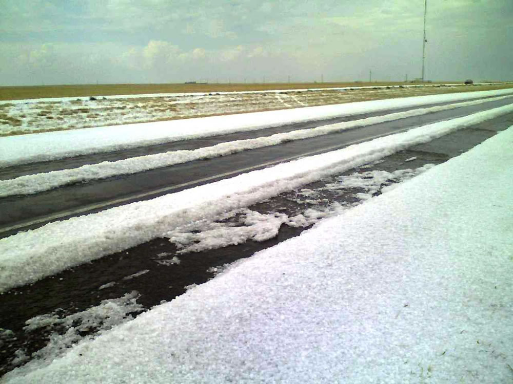
Hail on Highway 60 between Friona and Bovina - 23 April 2008
|
2008 was a rather benign year in terms of the number of tornadoes reported. A total of 8 tornadoes were observed across the 24 county warning area of responsibility for the Lubbock NWS. This is considerably less than the record number of 43 tornado observed in 2007. Also, all the tornadoes of 2008 were rated EF0, and 7of the 8 tornadoes remained over open land and produced little or no damage. The one exception was a brief tornado that touched down on the north side of Lubbock, near north Loop 280 and Interstate 27, that severe damage the roof of a large metal warehouse and blew out a number of car windows.
In addition to the 8 tornadoes observed, a wet macroburst brought very strong wind and large hail to Childress on Father's Day (15 June). The storm damaged 1,821 homes of which 247 received major damage and 6 were destroyed. Also, more than 200 businesses were damaged and six people were injured.
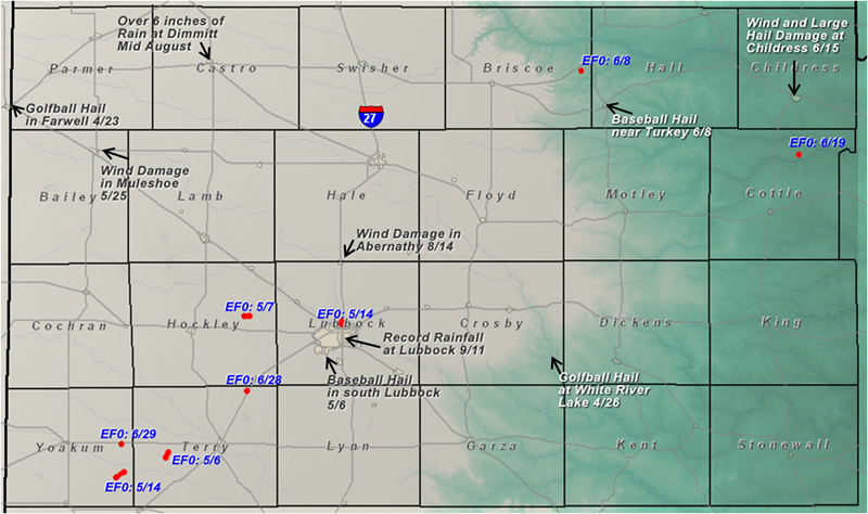
Other noteworthy weather events are plotted on the below map. If you would like more detailed information about the events plotted on the below map, or a more comprehensive summary of significant weather events in 2008, please refer to the following section.
|
|
|
Map displaying the tornadoes that impacted the Lubbock forecast area in 2008. Also plotted are other significant weather events of the year. Click on the image for a larger view.
|
|
|
| |
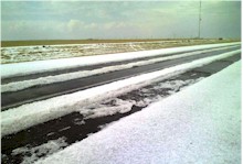
17th: A narrow band of morning snow brought about an inch to Post and Girard.
22nd: A beautiful lunar halo graced the skies over Lubbock, and probably much of the South Plains. To learn more about this halo and other atmospheric phenomena CLICK HERE.
28-29th: Strong westerly winds in excess of 60 mph impacted much of the South Plains and southwest Texas Panhandle. The Lubbock airport recorded a maximum wind speed of 66 mph. The strong winds downed trees and damaged utility lines between Plainview and Lubbock. Also, very dry air supported the development and spread of a 20,000 acre wildfire south-southwest of Muleshoe. The fire re-intensified early on the 29th, destroying a mobile home and a few vehicles.
31st: The passage of a cold front and vigorous storm system combined to bring a brief bout of snow and blowing snow to much of the South Plains. Although most locations recorded an inch or less of snow (Silverton was the high spot, receiving 2 inches of snow), the reduced visibilities and slippery roads resulted in more than 90 traffic accidents across the region.
16th: Localized freezing rain and drizzle resulted in ice accumulations near a quarter inch near Hale Center.
20th: Total Lunar Eclipse - CLICK HERE.
25th: A windy and dry day supported a significant wind-driven wildfire that burned 2,000 acres and destroyed a structure in Hale County.
2-3rd: A powerful storm system brought strong winds and accumulating snows to West Texas. Winds in excess of 50 mph visited all but the southern Rolling Plains. Also, higher locations near the Texas/New Mexico state line picked up 2-3 inches of snow. For a more detailed summary CLICK HERE.
6th: A period of light snow occurred over the southern Texas Panhandle and northern South Plains during the morning and early afternoon hours. Accumulations of 1-3 inches were observed from Friona to Turkey.
14th: Stout winds, very dry air and increasing drought contributed to the growth of at least a half dozen wildfires across the region. The largest of the fires burned 19,000 acres, damaged a number of ranch homes and destroyed two oil pipelines in eastern King County. A smaller wildfire destroyed two trailer homes near Lake Alan Henry.
1st: A potent storm system passing by to the north brought widespread high winds and blowing dust to the region. Wind speeds sustained over 40 mph were common, with a maximum gust of 72 mph reported at Lazbuddie and 71 mph at Friona. The strong winds blew three semi-trucks off of Interstate 27 near Abernathy, and another off Texas Highway 214 near Friona.
9-10th: Scattered thunderstorms developed in the morning hours over much of the South Plains and Rolling Plains as warm and moist air surged northward and was lifted over cool air at the surface. The strongest storms produced up to golf ball-sized hail at Swearingen. Storms redeveloped during the evening hours, again producing large hail, with golf ball-sized hail near Childress, Lorenzo and Paducah. The moisture moved to the east on the 10th, with stronger westerly winds and blowing dust moving in. Winds gusted in excess of 60 mph over much of the southern Texas Panhandle and northern South Plains. To read a more detailed report CLICK HERE.
16th: Gusty winds and very dry conditions supported the spread of at least three wildfires in Garza and Dickens Counties. Although the fires remained over rural locations, one did destroy oil lines east of FM 669 in southern Garza County.
23rd: Elevated severe thunderstorms developed over portions of the South Plains, with tornadic storms along the boundary across the Permian Basin. A wind gust to 67 mph was observed near Anton, with golf ball sized-hail at Farwell and near Bovina. To learn more about this event CLICK HERE.
26th: High based thunderstorms developed along a dryline over the eastern South Plains and moved into the Rolling Plains. These storms produced hail, up to golf ball-sized, with hail falling at both White River Lake and Lake Alan Henry. Read more about this event HERE.
5th: Scattered thunderstorms that developed over the western South Plains organized into a linear complex that produced hail large hail, damaging winds and heavy rain. A few highlights include golf ball-sized hail at Whiteface and Levelland and a 62 mph wind gust near Anton. To learn more about this event CLICK HERE.
6th: Numerous severe thunderstorms developed across the South Plains, some with giant hail and damaging winds. Softball-sized hail was observed with one storm near Olton, with baseball-sized hail falling on the south side of Lubbock. Also, a 74 mph wind gust was recorded near Floydada, and a brief tornado touched down without incident near Wellman. To learn more about this event CLICK HERE.
7th: Strong to severe thunderstorms developed within the core of an upper level storm system. These storms produced copious hail (up to 1” diameter) across the city of Lubbock, and later severe winds near Guthrie. Also, a brief landspout tornado formed north of Smyer. Learn more about this event HERE.
13th: A severe thunderstorm produced 1” hail on the Four 6’s Ranch east of Guthrie.
14th: Severe thunderstorms produced a brief tornado east of Denver City (with no damaged reported), with another on the north side of Lubbock. The tornado in Lubbock struck Beck Steel industrial facilities and severely damaged the roof of a large metal warehouse. Nearby, parked cars had their windows blown out.
21st: High based showers falling into a very dry lower atmosphere produced light rain, but did generate strong winds (measured up to 71 mph near Sundown) and areas of blowing dust from Whiteface to Ropesville to Lubbock. In addition to minor tree and structural damage, the downburst activity contributed to a crash landing of an U.S. Air Force jet near Lubbock Preston Smith International Airport.
22nd: A severe thunderstorm brought penny-sized hail near Lakeview.
25th: Showers and thunderstorms that developed near the Texas/New Mexico state line move quickly across the northwest South Plains and southwest Texas Panhandle, producing large hail, strong winds, and blowing dust as they did so. A wind gust to 78 mph was recorded near Plains, with a gust to 79 mph observed near Morton. Also, golf ball-sized hail occurred at Lazbuddie and Muleshoe. To learn more about this event CLICK HERE.
27th: A number of individual thunderstorms evolved into a complex, moving over much of the central and southern South and Rolling Plains. Very heavy rain, large hail and strong winds occurred with the storms, including reports of golf ball-sized hail near Roaring Springs, Afton and Meadow. A more detailed report can be found HERE.
29th: A lone low precipitation supercell produced penny-sized hail near Maple.
5th: A broken line of severe thunderstorms developed along the dryline over the southern Rolling Plains. These storms produced damaging winds over portions of King and Stonewall Counties where more than 50 utility poles were downed.
6th: A decaying thunderstorm complex brought a swatch of high winds to portions of Hockley, Lamb and Hale Counties.
8th: Scattered thunderstorms tracked across the southern Texas Panhandle. One supercell storm produced golf ball-sized hail east of Kress and baseball-sized hail northeast of Quitaque and northwest of Estelline. Also, a brief tornado was observed in open country northeast of Quitaque. To read a more detail summary of this event CLICK HERE.
13th: An isolated storm produced winds measured to 59 mph near Guthrie.
Active second half of June: CLICK HERE for the details.
14th: Scattered strong to severe storms affected the South and Rolling Plains. Hail to the size of ping pong balls occurred at Lakeview, with a 72 mph gust recorded at Ralls.
15th: An extremely damaging thunderstorm impacted the Childress area with hail and winds estimated to 100 mph. Almost every structure in Childress sustained damage, including more than 1,800 homes and 200 business. Six people were injured and economic losses totaled $20 million. To learn more CLICK HERE.
16th: Thunderstorms tracked from Caprock Canyons area southeast through the Rolling Plains, with strong winds and large hail. Hail to the size of golf balls was reported east of Quitaque. Also, strong winds impacted Aspermont damaging a number of homes and structures.
17th: A couple of supercell thunderstorms dropped giant hail to the southwest Texas Panhandle and the western South Plains. Muleshoe received softball-sized hail, with baseball-sized hail reported at Friona, east of Farwell, west of Morton and in Plains. Total damages from the storms were estimated to exceed $3.5 million.
19th: Scattered thunderstorm developed across the central Texas Panhandle, then became widespread as they tracked southward over nearly all of the South and Rolling Plains. Many of the storms were severe with large hail up to the size of golf balls and damaging winds in excess of 70 mph. Also, one brief tornado was reported early on over open country north of Paducah.
21st: A lone thunderstorm dumped heavy rain and penny-sized hail to Happy.
22nd: A storm brought 1” diameter hail to Friona and a 62 mph gust to Hart.
23rd: A thunderstorm complex that moved through the northwest and central South Plains generated damaging winds and blowing dust. A peak wind gust of 74 mph was measured near Anton.
24th: A batch of severe thunderstorms moved into the southwest South Plains, with strong winds and large hail. Quarter-sized hail was reported in Brownfield.
26th: An isolated storm brought penny-sized hail southwest of Brownfield.
28th: Scattered thunderstorms brought quarter-sized hail and strong winds to parts of Cottle and King Counties. The storms developed southwest, with a new storm on their outflow producing a brief landspout tornado near Meadow. No damage was reported.
12th: Scattered thunderstorms erupted over the central South Plains, then organized into a complex and tracked across the southern Rolling Plains. Early on, the storms produced up to golf ball-sized hail on the north side of Lubbock, with wind gusts near 60 mph at Slaton, Southland and Justiceburg.
9-18th: Much of West Texas received beneficial rainfall during a 10-day period in mid-July, with 1-3 inches of total rain common. Aside from the 12th, most of the precipitation fell from non-severe thunderstorms. To learn more about this period of rain CLICK HERE.
27th: Isolated storms developed over the extreme southeast Texas Panhandle and Rolling Plains as temperatures climbed to 100 to 105 degrees. Isolated occurrences of strong winds occurred with these storms, including a measured gust to 73 mph near Turkey.
28th: An isolated severe wind gust from a thunderstorm caused significant damage to a number of tin and light weight metal structures and knocked out a few car windows in Memphis.
10-19th: A wet weather pattern, with occasional strong and severe thunderstorms impacted West Texas. To learn more CLICK HERE.
11th: An isolated severe storm brought 1” diameter hail near Pettit and nickel-sized hail to Bledsoe. Also, extensive lightning caused damage in Lubbock.
13th: Scattered thunderstorms that developed over the southwest Texas Panhandle tracked southeast into the central South Plains. Hail to the size of quarters was reported near Dimmitt and Earth, with a wind gust to 65 mph at Muleshoe and 70 mph near Amherst. In addition, lightning started at least three house fires in Lubbock.
14th: A line of thunderstorms plunged from the southwest Texas Panhandle through much of the South and Rolling Plains with numerous reports of wind gusts between 60 and 65 mph. One particularly strong wind gust near Abernathy blew a roof off of one industrial size metal structure, while another lost a portion of its roof.
16th: A complex of strong thunderstorms produced widespread heavy rain from the southwest Texas Panhandle through the northwest and central South Plains.
28th: An isolated storm produced heavy rain and localized flooding in portions of Swisher County.
Late Aug-early Sept: The region saw a number of unusually colored sunrises and sunsets. These brilliant displays were attributed to optical effects resulting from tons of sulfur dioxide, dust, and ash that circled the globe after being belched into the upper atmosphere by Mount Kasatocki in Alaska. To learn more about this CLICK HERE.
5th: An isolated severe thunderstorm spilled nickel-sized hail near Hart.
10-12th: Very heavy rain fell across much of the South and Rolling Plains. Lubbock received a record 24-hour rainfall of 7.80”, which resulted in widespread flooding. To learn more about the copious amounts of rainfall CLICK HERE.
11-15th: A number of rounds of rain impacted the region, with many locations receiving one to three inches of rainfall over the five day period. No severe weather was reported as the instability was insufficient for strong storms. For a more detailed summary of the widespread heavy rains please CLICK HERE.
Entire month: November was a rather tranquil month, with monthly rainfall totals generally under 0.1 inches. Most of the minimal precipitation fell in the last few days of the month as chilly rain showers.
8th: A passing storm system brought a little light precipitation to a few locations, but its main impact was strong winds across the southwest South Plains, where widespread winds around 60 mph were reported. The strongest wind gust of 65 mph was recorded near Denver City. To read a story about this event created by the West Texas Mesonet CLICK HERE.
14th: Widespread strong winds developed across West Texas, with the strongest winds lifting widespread blowing dust across the central and western South Plains. Visibilities briefly dropped to under one mile from blowing dust around noon in Lubbock. The top measured wind speed was 72 mph at Tatum, NM, with widespread observations of 60-66 mph over the western South Plains. To read a story about this event CLICK HERE.
27th: Another round of strong winds and blowing dust visited West Texas. The winds quickly increased during the morning, with the peak of the event in the late morning to around noon. Wind speeds dropped and conditions rapidly improved in the afternoon. Wind gusts topped out around 45 to 50 mph at most locations. Farther north, snow fell across the central and northwest Texas Panhandle.


