
Scattered thunderstorms with severe gusts, hail and a tornado risk are possible near a cold front from the Ohio Valley to the Mid-Atlantic tonight. Tropical Storm Bertha is expected to bring tropical storm conditions to portions of the Gulf Coast from the panhandle of Florida into Louisiana through Wednesday. Read More >
|
A Round of Wet Snow Falls |
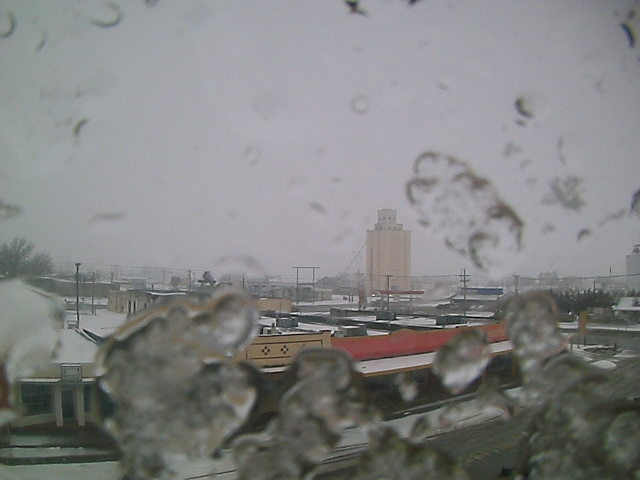 |
| Picture of snow falling (and partially obscuring the view) at Muleshoe around 2 pm on Sunday, February 6, 2011. The image is courtesy of KAMC. |
| Several upper level disturbances combined with a weak cold front and sufficient moisture to bring periods of wet snow to the South Plains region on Sunday, February 6, 2011. Initially, temperatures were rather mild, and many locations experienced light rain early Sunday morning. However, as the precipitation intensity increased, the air cooled just enough to allow the precipitation to change over to snow, with nearly everybody on the Caprock and into the Rolling Plains seeing at least a period of snow. Throughout the day temperatures remained near or just above the freezing mark, so impacts were rather limited, with most roads remaining wet and occasionally slushy during the heaviest snows. The precipitation rapidly came to an end during the late afternoon and early evening hours as the upper level forcing shifted east of the area. |
|
|
| Snow totals for Super Bowl Sunday. Click on the image for a larger view. |
|
The relatively warm temperatures made the measurement of snowfall difficult, as many locations saw the snow melt nearly as fast as it fell. Still, as the above map shows, many spots reported between a trace and an inch of snow, with 2 to 4 inches fairly common across the southwest and south-central Texas Panhandle. This wet snow did bring beneficial moisture to the region, with most places receiving between a tenth and a half inch of liquid water equivalent. If you would like to view the snow totals in text form, CLICK HERE for the Public Information Statement issued regarding this snow event. |
|
|
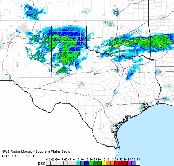
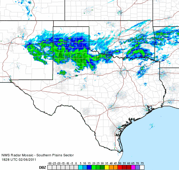
| Radar loop ending at 9:28 am on Sunday, February 6, 2011. To view a radar loop that ends at 1:38 pm on the 6th CLICK HERE. |
| The above radar loop shows that the heavier precipitation (mostly in the form of snow across West Texas), fell in two main batches. The first area of heavier snow tracked across the central South Plains during the early to mid-morning, with the second round moving through by early to mid-afternoon. |


