|
Showers and thunderstorms bring rain to much of West Texas 11 April 2026 |
|
 |
|
|
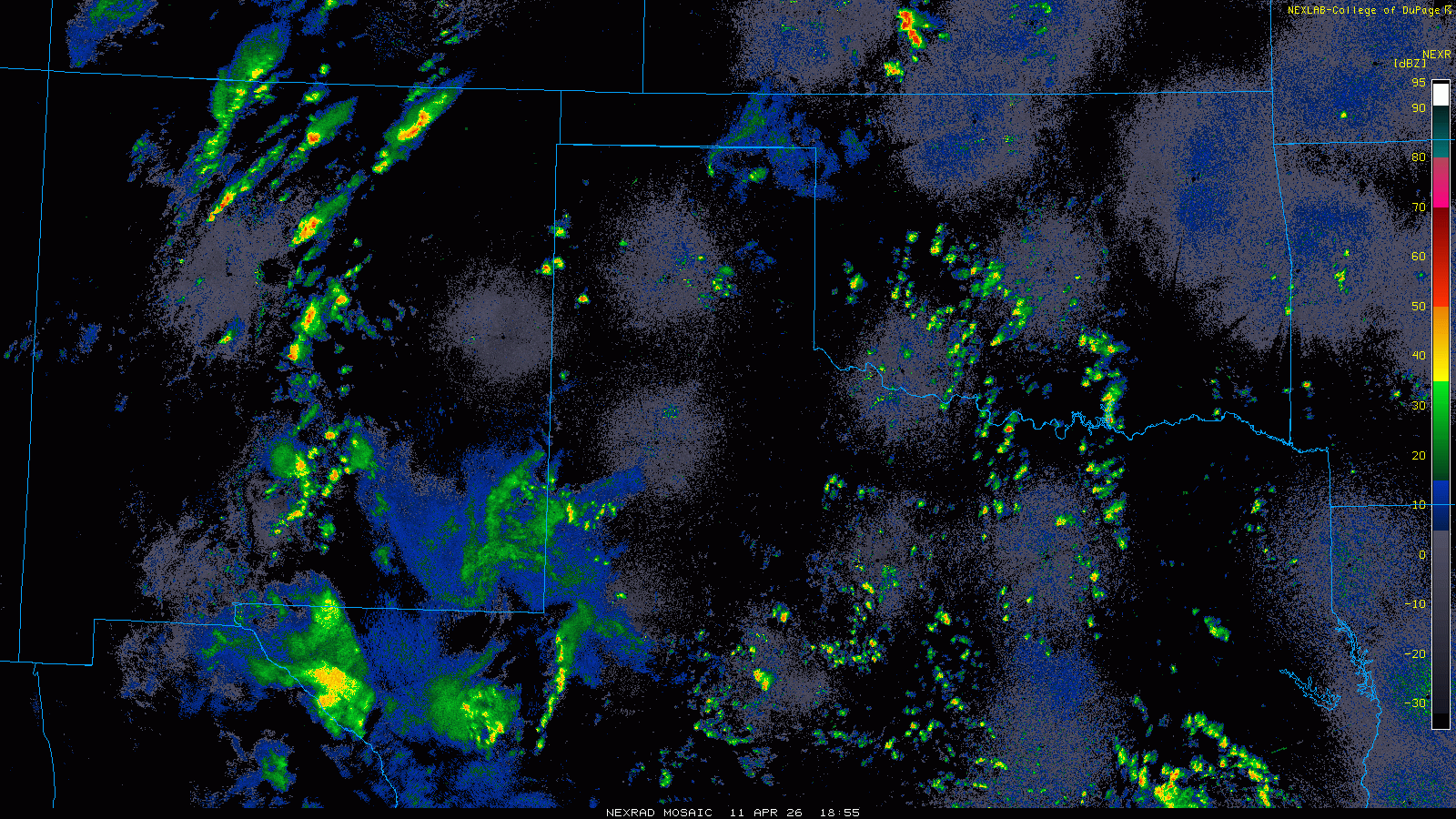
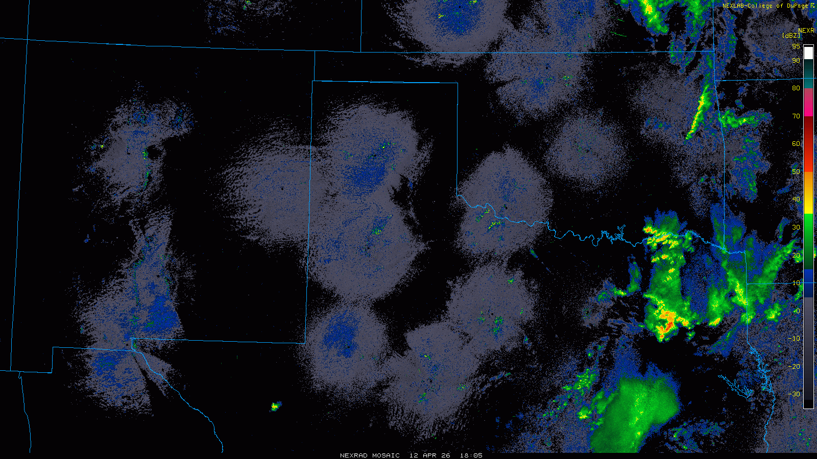
Regional radar animation valid from 1:55 pm on Saturday to 2:15 am on Sunday (11-12 April 2026). An "RGB-True Color" satellite loop, valid from 12:31 pm to 65 pm on Saturday, can be VIEWED HERE. |
|
|
The afternoon and evening of Saturday, April 11th, brought numerous showers and thunderstorms to the South Plains region. Both instability and wind shear were rather meager, which limited both the organization and intensity of the activity. However, decent moisture was present in the atmosphere and that promoted bursts of heavy rainfall with the strongest activity. |
|
 |
|
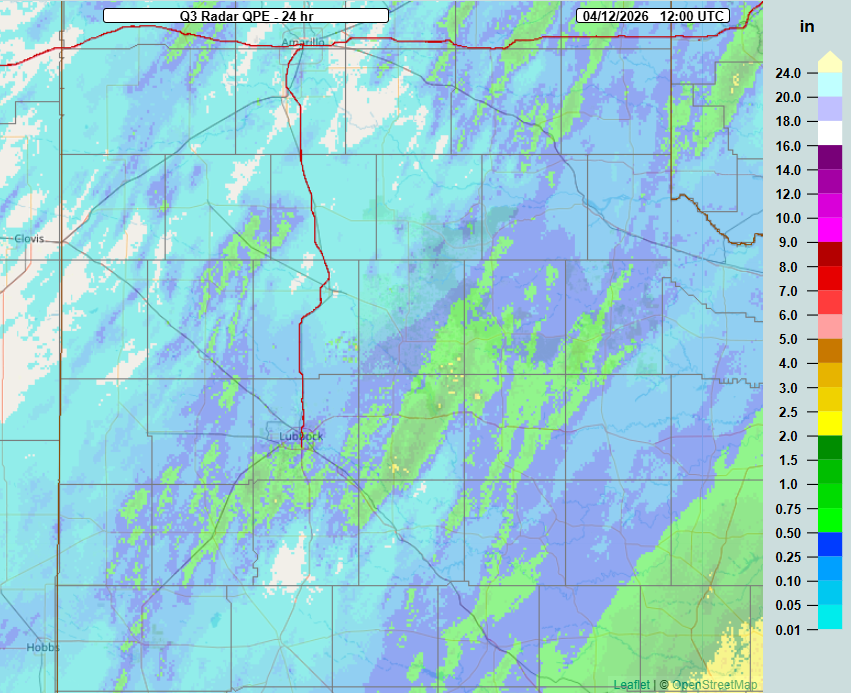
| 24-hour radar-estimated and biased-corrected precipitation ending at 7 am on Sunday (12 April 2026). | |
| The showery activity brought swaths of heavier rainfall, with several spots tallying over a half inch of rain Saturday afternoon and evening. A few select locations measured totals in excess of 1 inch, including the West Texas Mesonet (WTM) site 6 miles south-southwest of Wolfforth, which measured 1.37 inches. | |
 |
|
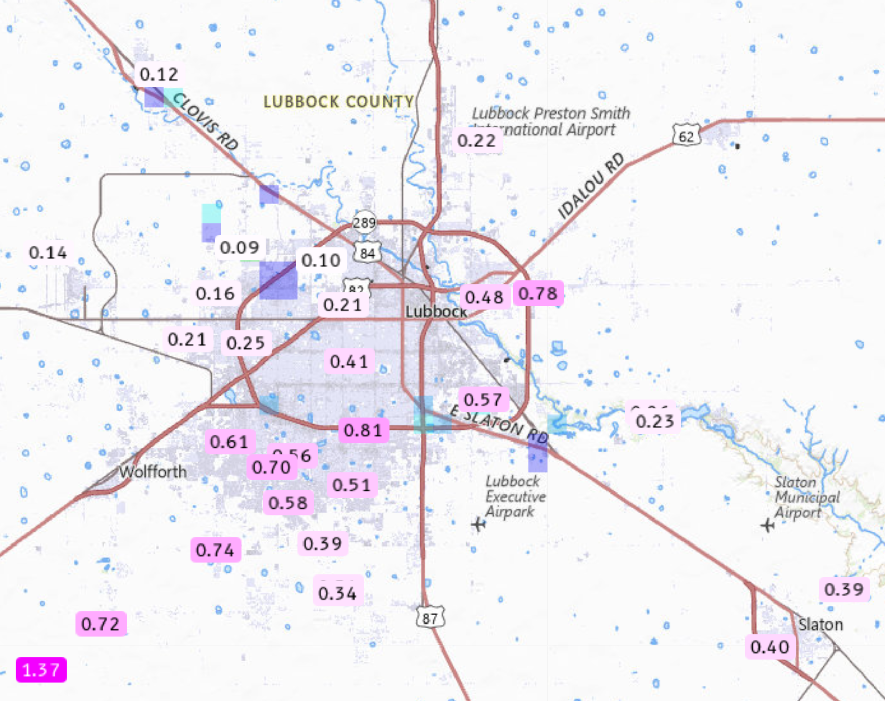
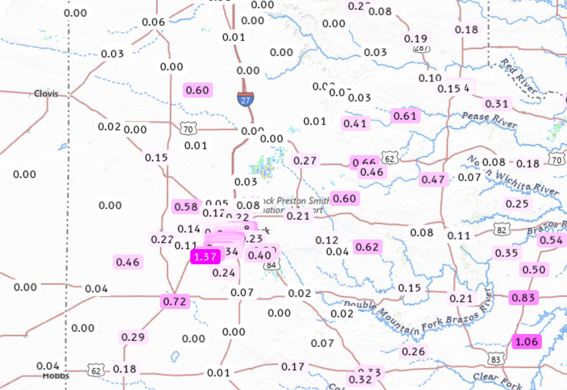
| 24-hour rainfall around Lubbock, valid through 9:45 am on Sunday (12 April 2026). The data are courtesy of the National Weather Service (NWS) and West Texas Mesonet (WTM). A South Plains-wide perspective can be FOUND HERE. | |
| Overall, the southeast two-thirds of the city of Lubbock was relatively lucky, receiving a quarter to over three-quarters of an inch of rain. Unfortunately, not everyone saw meaningful rain, with parts of the southern, northwestern and north-central South Plains getting little to none. Officially, the Lubbock Airport was on the lighter side, only measuring 0.09 inches of rain. | |
 |
|
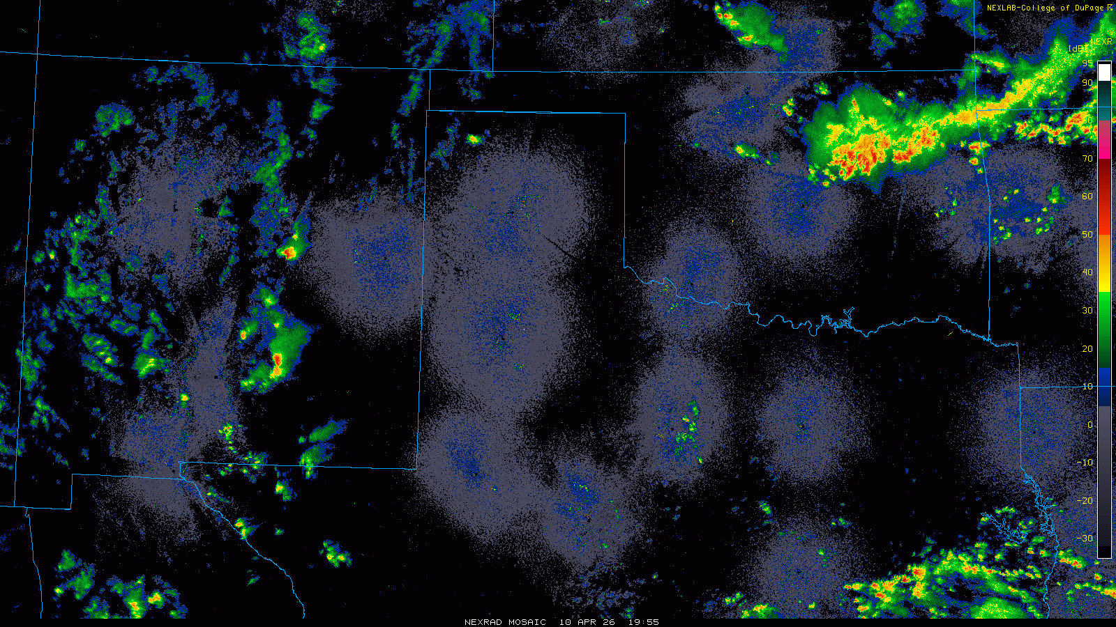
| Regional radar animation valid from 2:55 pm on Friday to 6:55 am on Saturday (10-11 April 2026). | |
| The active weather wasn't confined to Saturday. Ahead of the storm system that inspired the rain on Saturday, scattered showers and thunderstorms affected much of central and eastern New Mexico, and the western Texas Panhandle, from Friday afternoon into Friday night. The thunderstorms generally weakened as they cross out of New Mexico into the southwestern Texas Panhandle and northwestern South Plains, but they still provided rain for Parmer County and parts of Bailey County. Areas in and around Friona reported just over a quarter inch, with higher totals likely farther to the west, near and west of the state line. | |
 |
|
| Regional radar animation valid from 1:05 pm to 9:05 pm on Sunday (12 April 2026). | |
| The weekend concluded with more isolated thunderstorm activity, this time focused over the central and northern South Plains and central Rolling Plains. Rainfall on Sunday afternoon and evening was spotty and generally light due to relatively dry air that had moved into the region. The dry lower atmosphere also promoted gusty downburst winds, in excess of 45 mph at times. One of these small storms produced a rogue wind gust to 59 mph as it traversed the West Texas Mesonet (WTM) site on the northeast side of Memphis. | |
 |
|
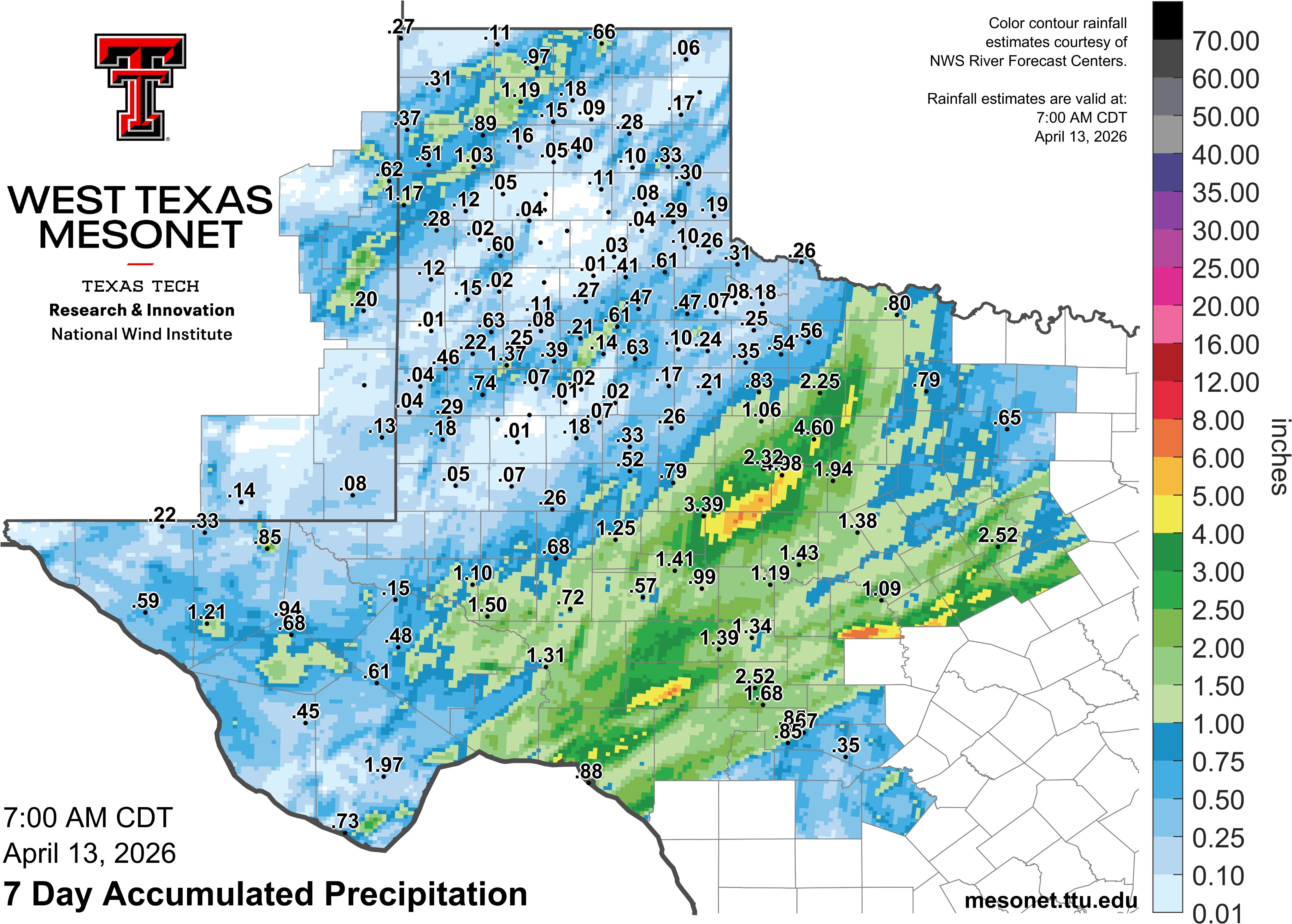
| 7-day rainfall total for much of the western half of Texas, valid through 7 am on Monday (13 April 2026). The data are courtesy of the West Texas Mesonet. | |
|
The following day, Monday, April 13th, brought additional thunderstorms during the afternoon and evening, confined to the southern Rolling Plains. This activity affected the central and eastern parts of Stonewall County, including Aspermont, and produced a 66 mph gust at the WTM site northeast of town. The rainfall over this mid-April stretch wasn't confined to West Texas. Even heavier rain totals were common over much of the Big County into parts of the Edwards Plateau. The WTM sites near Albany and Clyde measured 4.60 inches and 4.98 inches, respectively, through this active stretch. A list of the preliminary storm reports collected by WFO Lubbock can be found below. |
|
Preliminary Local Storm Report...Summary
National Weather Service Lubbock TX
1051 PM CDT Sun Apr 12 2026

..TIME...   ...EVENT...      ...CITY LOCATION...     ...LAT.LON...
..DATE...   ....MAG....      ..COUNTY LOCATION..ST.. ...SOURCE....
            ..REMARKS..

0548 PM     Tstm Wnd Gst     1 NE Memphis            34.73N 100.53W
04/12/2026  M59 MPH          Hall               TX   Mesonet

            Memphis WTM Gust to 59 MPH at 5:48 PM CDT.

