|
Welcome relief from the heat and dry conditions |
|
 |
|
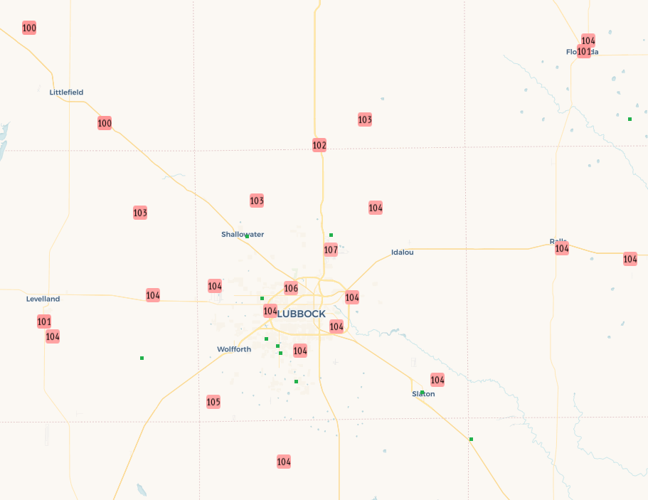
| High temperatures recorded on Friday (8 September 2023). Data are courtesy of the West Texas Mesonet and the National Weather Service. | |
|
The hot and dry conditions that prevailed over West Texas for most of the summer persisted into early September. In fact, many locations in the South Plains region saw highs at or above 100 degrees the first 8 days of the month. This included a daily and monthly record high of 107 degrees observed at the Lubbock International Airport on Friday, September 8th. This also marked the 46th day that Lubbock measured a high at or above 100 degrees in 2023, second only to the 48 days of triple digit heat experienced in 2011. |
|
 |
|
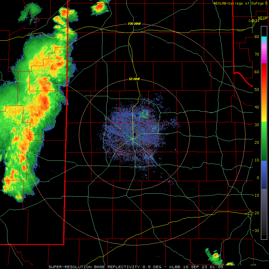
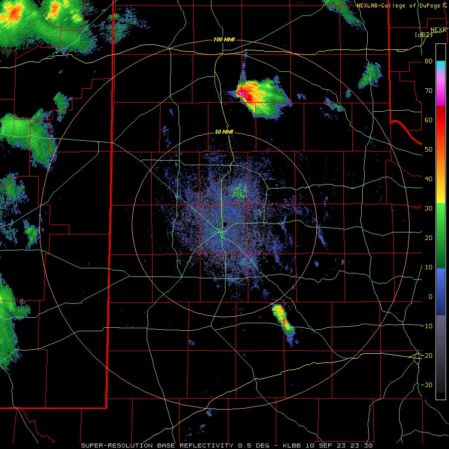
| Lubbock WSR-88D radar animation valid from 8:05 pm Saturday (9 September 2023) to 10:22 am on Sunday (10 September 2023). Additional radar animations can be found at: 6:30 pm to 9:03 pm on Sunday (10 September 2023); and 10:06 pm Sunday (10 September 2023) to 6:15 am on Monday (11 September 2023). | |
| Thankfully, a gradual change in the weather pattern resulted in a cooling trend, and also provided increased moisture levels that fueled several rounds of showers and thunderstorms through mid-September. Initially, as the mid-level ridge that provided the seemingly endless heat slowly faded, temperatures moderated through the weekend of September 9th and 10th. In addition, the first of several upper level disturbances emerged from the southern Rockies within the newly energized westerly flow aloft. In response, thunderstorms that developed over the higher terrain of New Mexico Saturday afternoon (9 September) managed to endure their trek across the state line, bringing scattered thunderstorms to the western South Plains late Saturday evening. Although not everyone saw rain, scattered thunderstorms managed to persist all night as they moved into the Rolling Plains, where they brought welcome heavy rain to some spots, including around 2 inches near Matador and north of Paducah. | |
 |
|
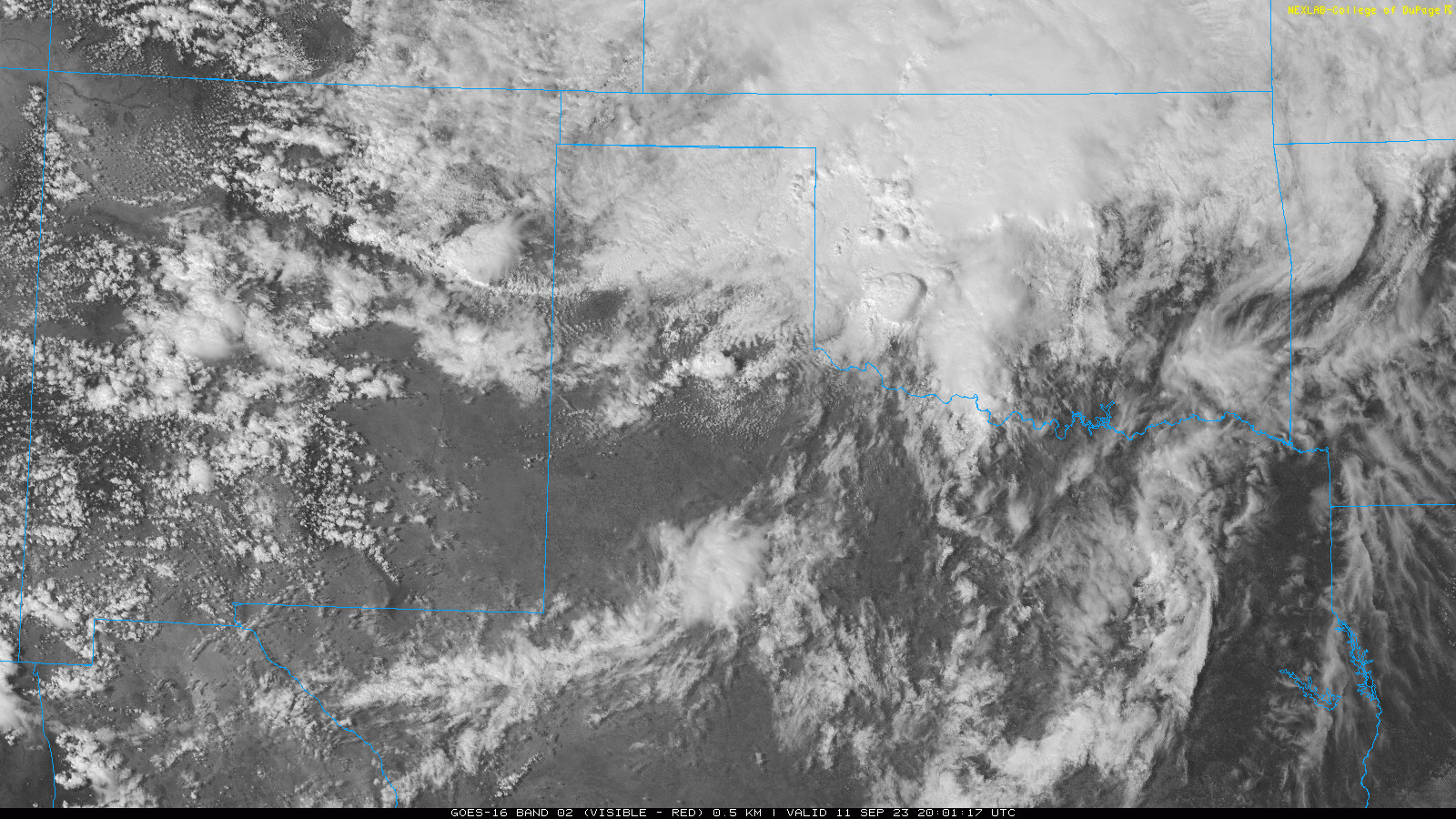
| Visible satellite image valid from 3:01 pm to 5:51 pm on Monday (11 September 2023). | |
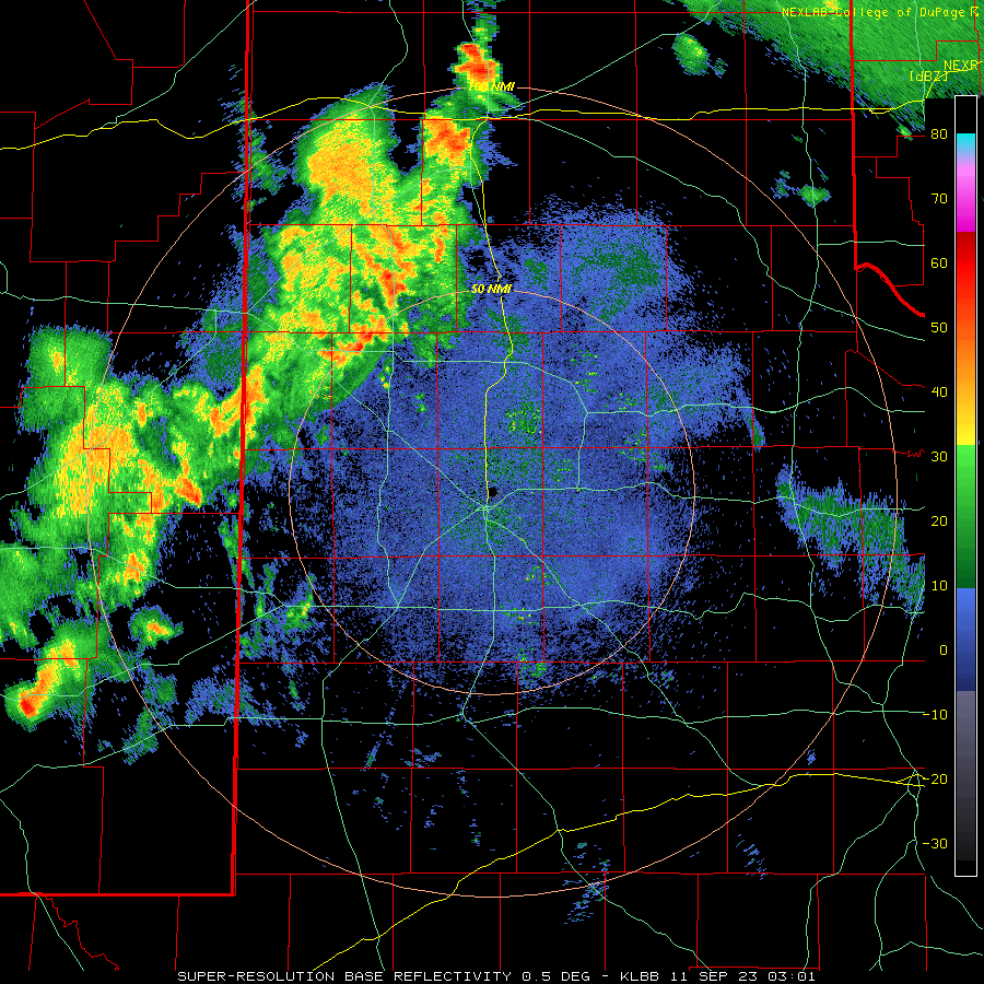
| Following a relatively quiet Sunday (10 September), aside from one severe storm that affected portions of northeast Swisher County Sunday evening, another round of scattered to numerous thunderstorms tracked across the South Plains region late Sunday night into early Monday morning. A few locations, including near Friona, Memphis and Post, recorded severe-caliber wind gusts as the overnight storms moved through. | |
 |
|
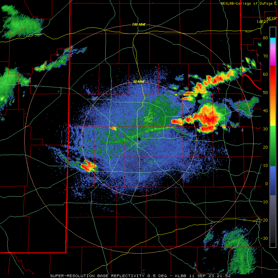
| Lubbock WSR-88D radar animation valid from 4:52 pm to 6:59 pm on Monday (11 September 2023). | |
| The first "real" cold front of fall then moved in from the north Monday afternoon (11 September). This front triggered another round of thunderstorms Monday afternoon and evening, while much-desired cooler air poured into the region behind the front. Temperatures by early Tuesday morning (12 September) were in the 60s, with even a few upper 50s mixing in across the northwestern South Plains. Thick clouds, combined with the northerly to easterly breezes, kept temperatures cool through the day Tuesday and again Wednesday, with highs only reaching the 60s and lower 70s. A few showers accompanied the clouds and cool air Tuesday and again Wednesday, but rain amounts were on the light side. | |
 |
|
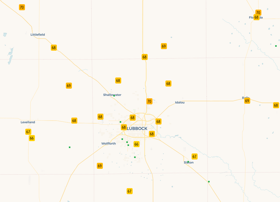
| High temperatures recorded on Tuesday (12 September 2023). Data are courtesy of the West Texas Mesonet and the National Weather Service. | |
|
That changed for some late Wednesday night into Thursday morning (14 September), when another mid-level impulse supported a cluster of showers and thunderstorms that tracked southeastward across the northern and central South Plains, then into the Rolling Plains. This activity brought modest amounts of lightning, but efficient rain rates for those lucky enough to get under them. |
|
 |
|
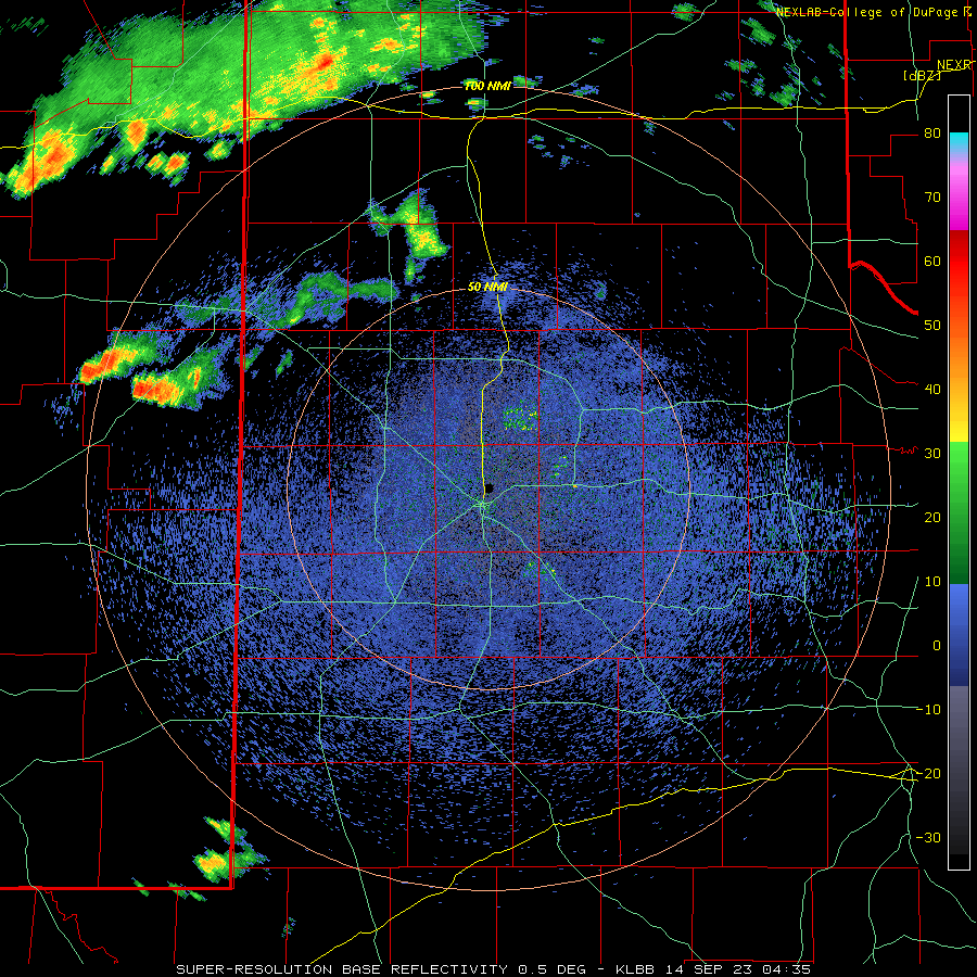
| Lubbock WSR-88D radar animation valid from 11:35 pm on Wednesday (13 September 2023) to 6:48 am on Thursday (14 September 2023). | |
| Over the course of this unsettled mid-September stretch, the entire region picked up some rain, with a number of locations through the central portion of the South and Rolling Plains getting 1 to 2+ inches | |
 |
|
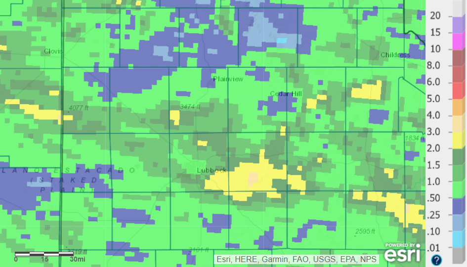
| 7-day radar-estimated and bias-corrected rainfall ending at 7 am on Thursday (14 September 2023). | |
|
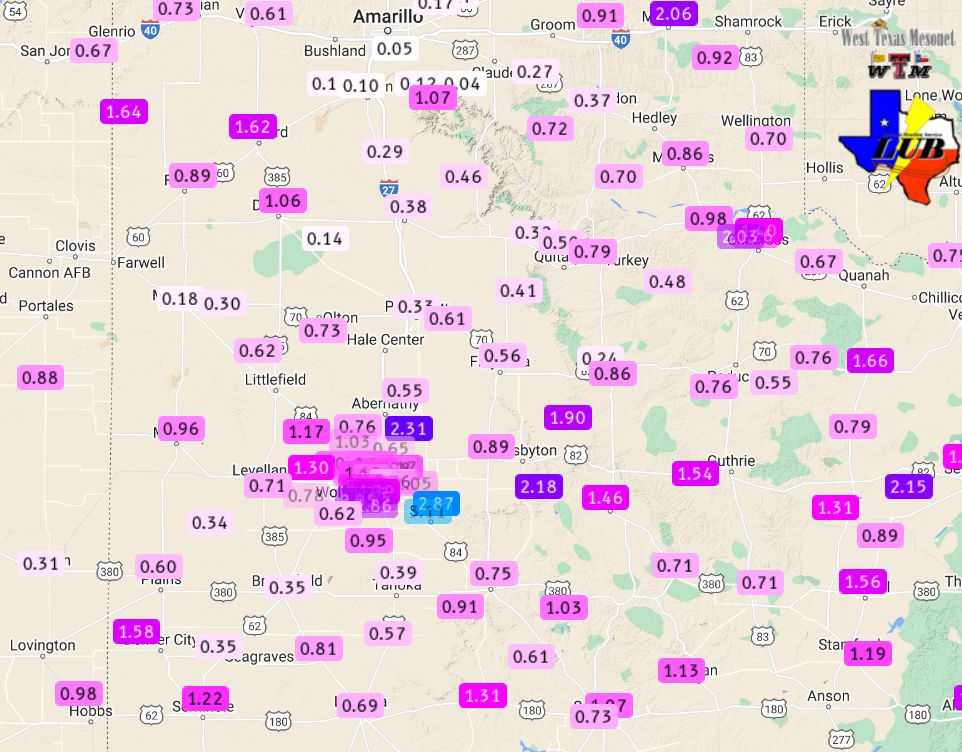
Officially, the Lubbock Airport measured 1.24 inches through 3 pm on the 14th, most of which fell early on the morning of the 14th. The Childress Airport measured 1.60 inches over through this same period. |
|
 |
|
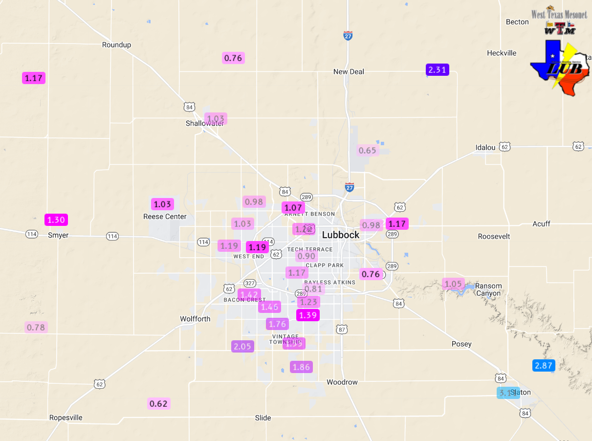
| 5-day rainfall ending at 1:30 pm on Thursday (14 September 2023) measured at various locations around the South Plains region. The data are courtesy of the West Texas Mesonet and the National Weather Service. Automated rain totals measured in and around the city of Lubbock over this stretch can be VIEWED HERE. | |
|
Additional rounds of rain, torrential in spots, and pockets of damaging winds followed Thursday night into early Friday (14-15 September) and again Friday night into early Saturday (15-16 September). To learn more about these rounds of intense thunderstorms CLICK HERE. Preliminary storm reports for September 10th and 11th can be found below: |
Preliminary Local Storm Report...Summary
National Weather Service Lubbock TX
928 AM CDT Mon Sep 11 2023

..TIME...   ...EVENT...      ...CITY LOCATION...     ...LAT.LON...
..DATE...   ....MAG....      ..COUNTY LOCATION..ST.. ...SOURCE....
            ..REMARKS..

0740 PM     Hail             13 E Tulia              34.54N 101.54W
09/10/2023  E1.00 inch       Swisher            TX   Broadcast Media

            Delayed report with picture of 1 inch
            hailstone.

0923 PM     Tstm Wnd Gst     2 NE Friona             34.65N 102.69W
09/10/2023  M60 MPH          Parmer             TX   Mesonet

            Measured by the West Texas Mesonet.

0930 PM     Tstm Wnd Gst     2 NE Friona             34.65N 102.69W
09/10/2023  M68 MPH          Parmer             TX   Mesonet

            Measured by the West Texas Mesonet.

1230 AM     Tstm Wnd Dmg     4.5 SE Memphis          34.68N 100.49W
09/11/2023                   Hall               TX   Law Enforcement

            Railroad crossing arm damaged from wind.

1230 AM     Tstm Wnd Dmg     5 S Southland           33.29N 101.55W
09/11/2023                   Garza              TX   CO-OP Observer

            Large tree limb downed.

1254 AM     Tstm Wnd Gst     1 NE Post               33.20N 101.37W
09/11/2023  M59 MPH          Garza              TX   Mesonet

0529 PM     Tstm Wnd Gst     10 WSW Guthrie          33.57N 100.48W
09/11/2023  M64 MPH          King               TX   Mesonet

