|
Additional rounds of severe thunderstorms and heavy rain 6-10 June 2025 |
|
 |
|
|
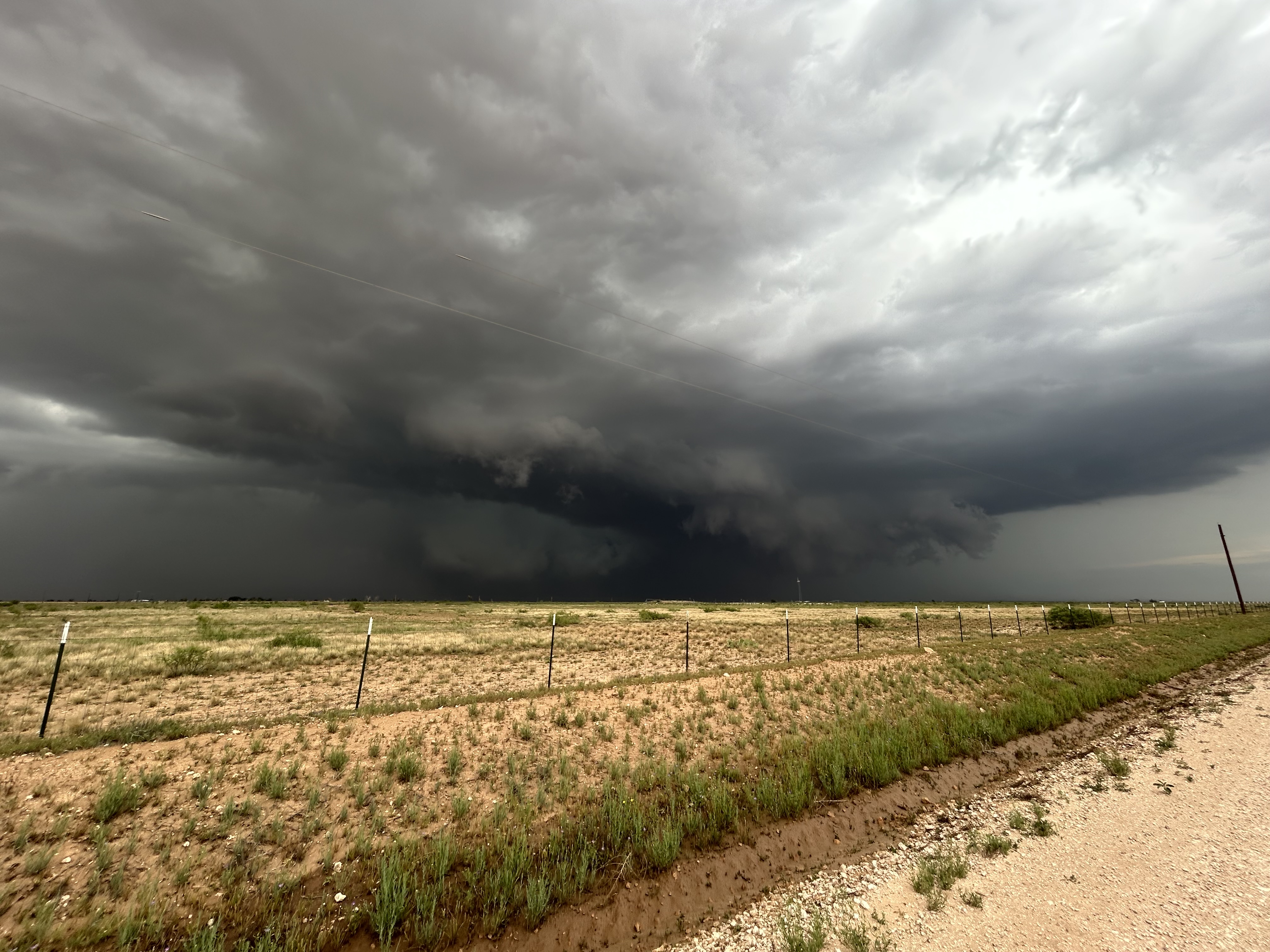
Supercell thunderstorm photographed over southeast Lubbock County Friday evening (6 June 2025). The picture is courtesy of Harrison Sincavage. |
|
|
Following a very active severe weather day, including several tornadoes, on June 5th, 2025, the weather didn't ease up over the coming days. Instead, early to mid-June continued to yield rounds of severe thunderstorms, and Friday (6 June) was no exception. |
|
 |
|
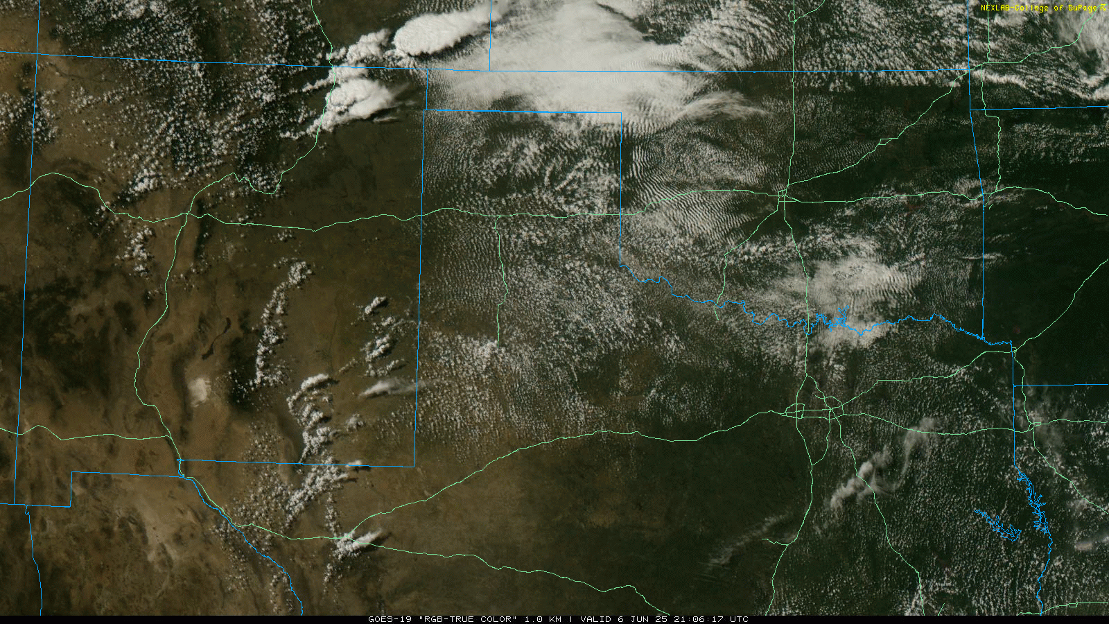
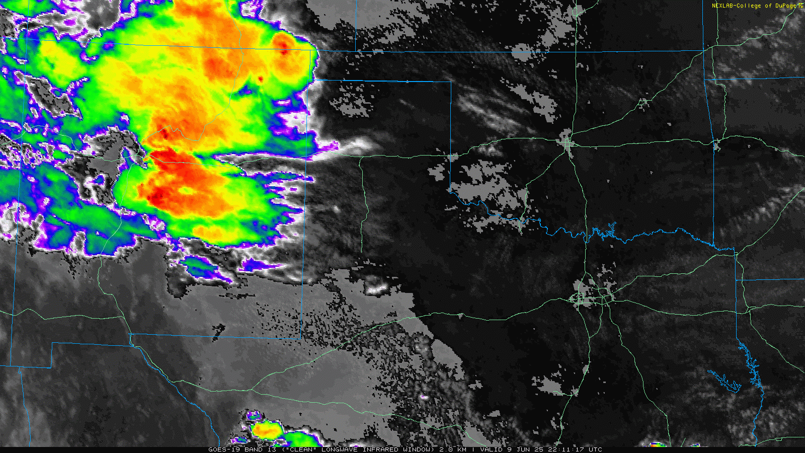
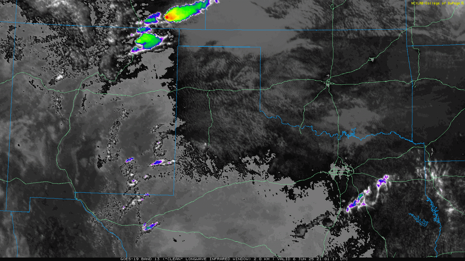
| "RGB-True Color" satellite animation valid from 4:06 pm to 5:31 pm on Friday (6 June 2025). An infrared satellite loop, valid from 4:01 pm on Friday to 8:21 am on Saturday (6-7 June), can be VIEWED HERE. | |
| As temperatures warmed into the upper 80s and lower 90s, scattered thunderstorms erupted late Friday afternoon over eastern New Mexico and the South Plains. Strong instability and sufficient wind shear caused these thunderstorms to quickly organize and become severe, taking on supercellular characteristics. The rotating thunderstorms proceeded to track eastward across the South Plains, Rolling Plains and southern Texas Panhandle Friday evening and overnight, dropping large hail and torrential rain, as well as generating severe wind gusts and even a few brief tornadoes. | |
 |
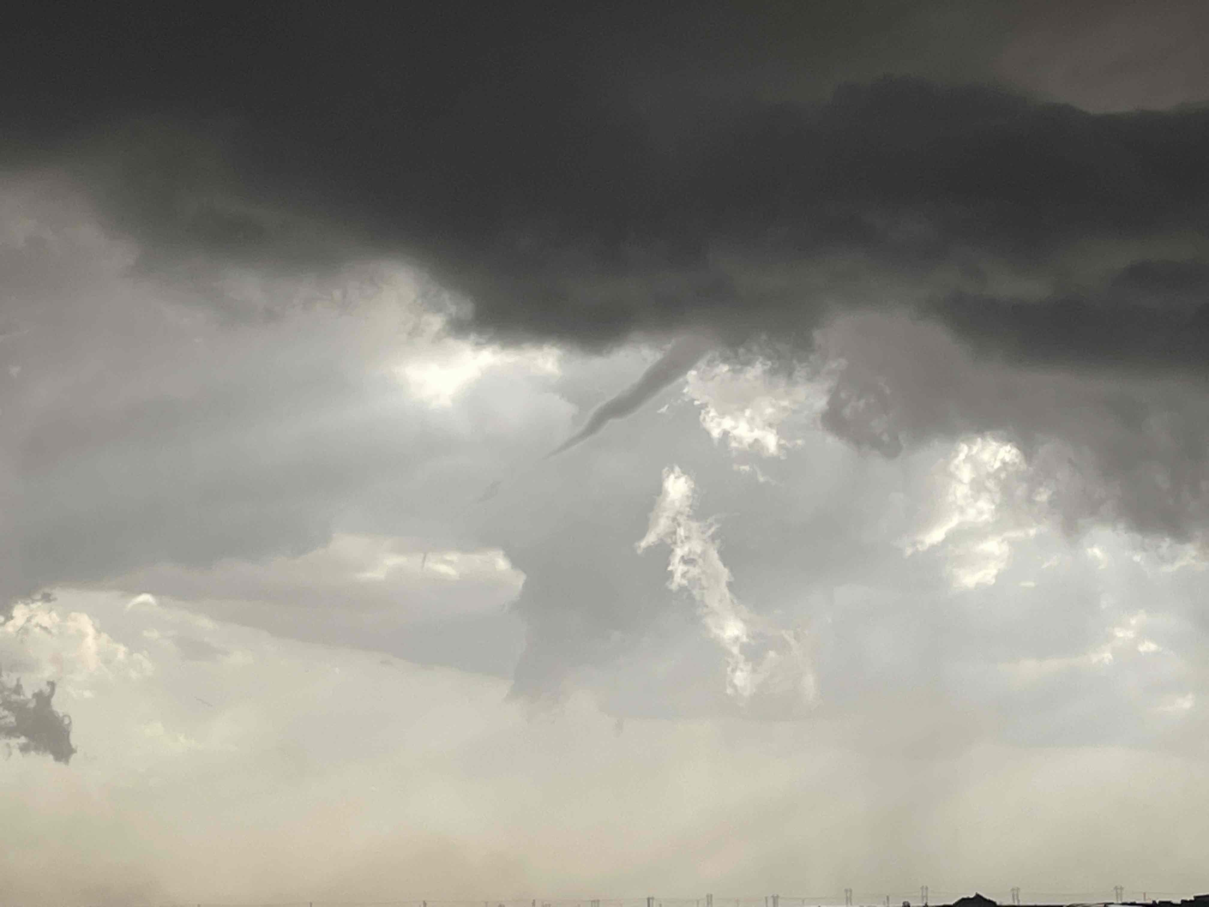 |
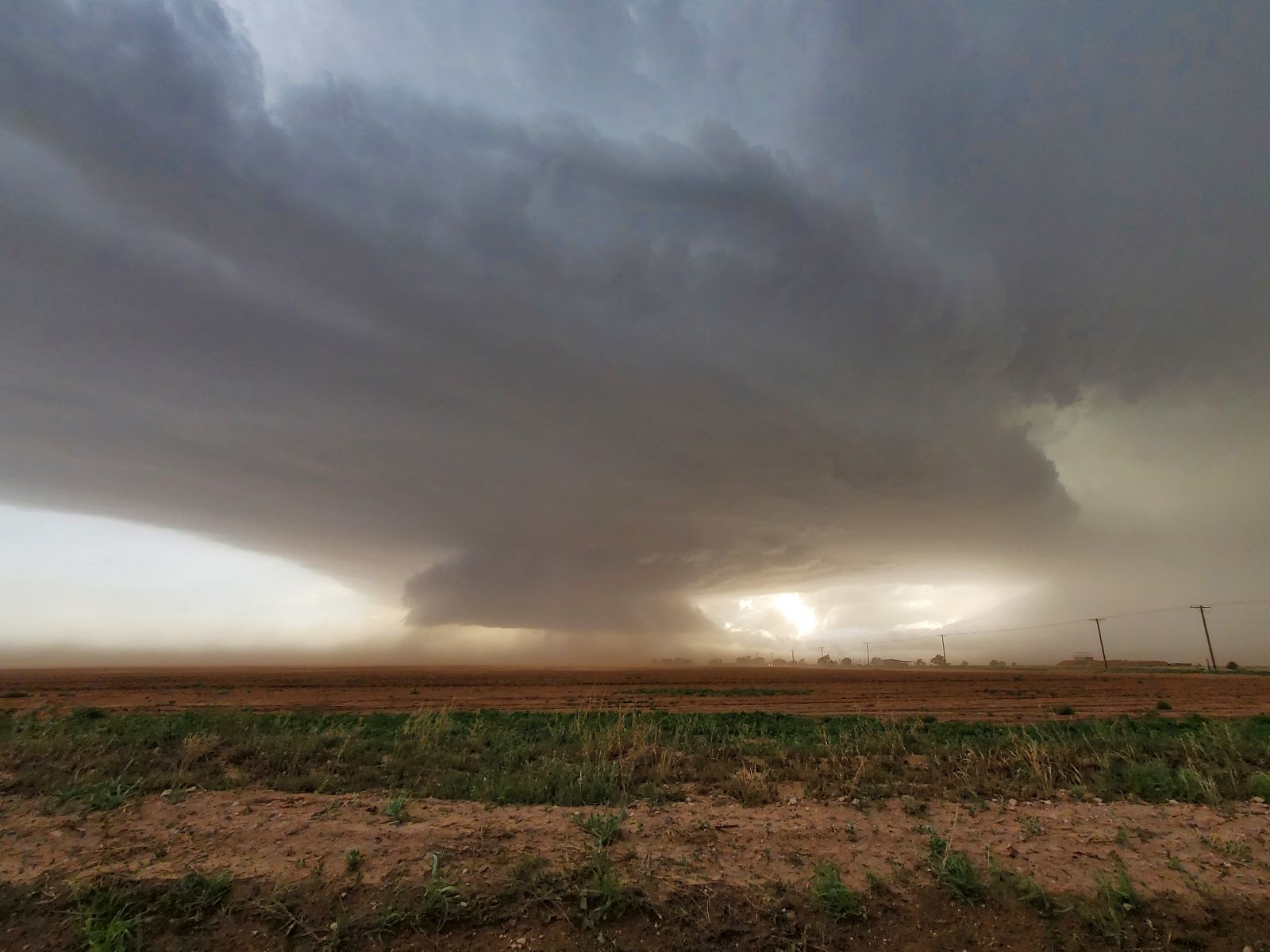
| (left) Supercell thunderstorm viewed from east of New Deal Friday evening (6 June 2025) around 8 pm. The image is courtesy of Timothy Silwinski. (right) Funnel cloud associated with a thunderstorm looking to the west-southwest of Ropes at 7:34 pm on Friday. The image is courtesy of Lyle Jones. | |
| One particularly intense supercell produced at least 3 brief tornadoes as it tracked across southern Hockley County, from near Sundown to west of Ropesville. Thankfully, these tornadoes were short-lived and inflicted no known damage. This same storm also went on to drop giant hail, as large as 3.25 inches in diameter west of Wilson and an 80 mph wind gust in New Home. | |
 |
|
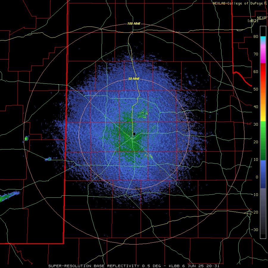
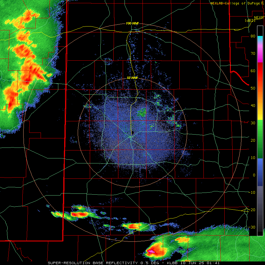
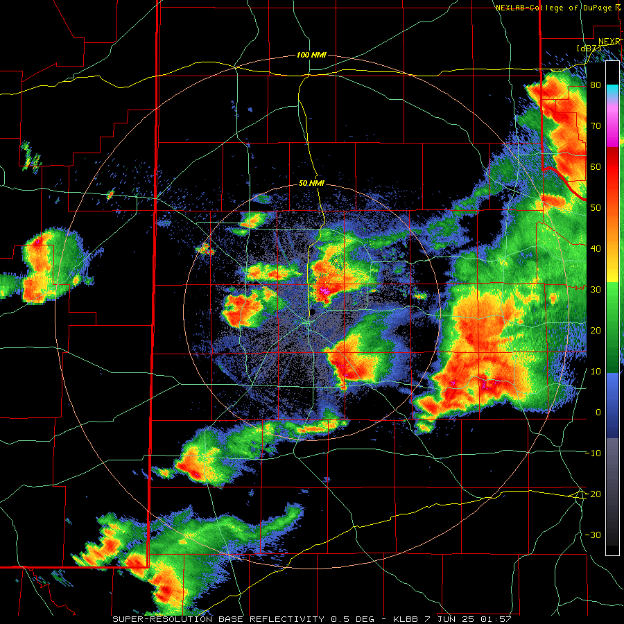
| LBB WSR-88D radar animation valid from 3:31 pm to 8:05 pm on Friday (6 June 2025). An additional radar animation, valid from 8:59 pm on Friday to 8:23 am on Saturday (6-7 June), can be VIEWED HERE. | |
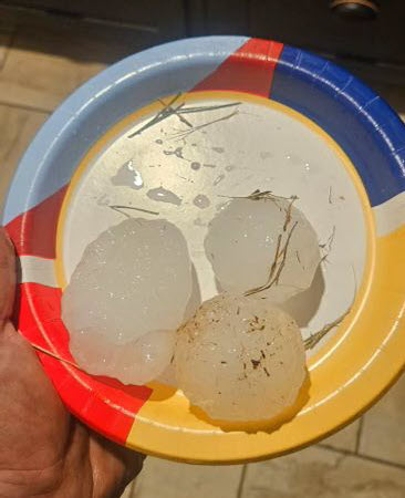
| The large hail wasn't confined to Hockley and Lynn Counties, but fell from nearly every thunderstorm traversing West Texas Friday afternoon and evening. This included hail close to baseball size that was observed north of Clairemont (see the photo below), and 2 inch diameter hail at the Lubbock Airport | |
 |
|
| Large hail that fell north of Clairemont on Friday evening (6 June 2025). The picture is courtesy of Jeremy Carter. | |
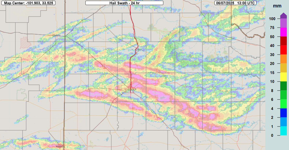
| The below graphic displays the swaths of hail, as inferred from radar, that fell across the South Plains region from late Friday afternoon through early Saturday. The largest hail generally followed a west-northwest to east-southeast track, associated with cyclonically rotating supercells. Additional hail swaths, oriented from southwest to northeast, were associated with anticyclonically rotating supercells. | |
 |
|
| Multi-Radar Multi-Sensor (MRMS) 24-hr hail swath (mm) ending at 8 am on Saturday (7 June 2025). | |
| Even well after sunset, thunderstorms continued to roil across the region. Specifically, a broken line of thunderstorms targeted the northern South and Rolling Plains around and after midnight. This late-night activity generated strong to severe wind gusts, as well as heavy rain, as it tracked repeated from west-to-east. A wind gust as high as 73 mph was measured at the Hackberry West Texas Mesonet (WTM) at 2:15 am on Saturday, while numerous reports of 50 to 60+ mph were observed by the WTM from Muleshoe to Plainview to Matador and Paducah between midnight and 3 am Saturday. | |
 |
|
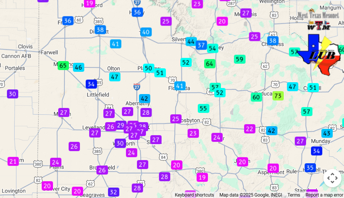
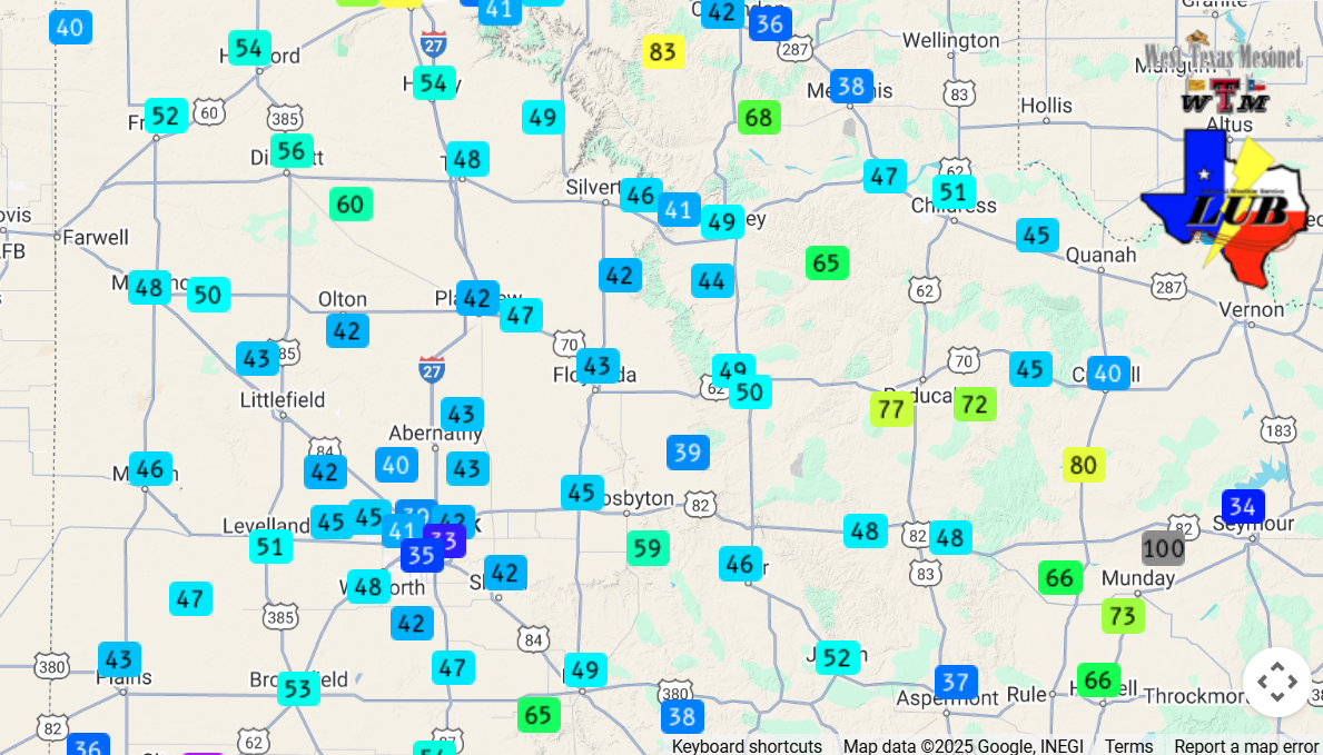
| Peak wind gust measured by the West Texas Mesonet (WTM) early Saturday morning (7 June 2025). | |
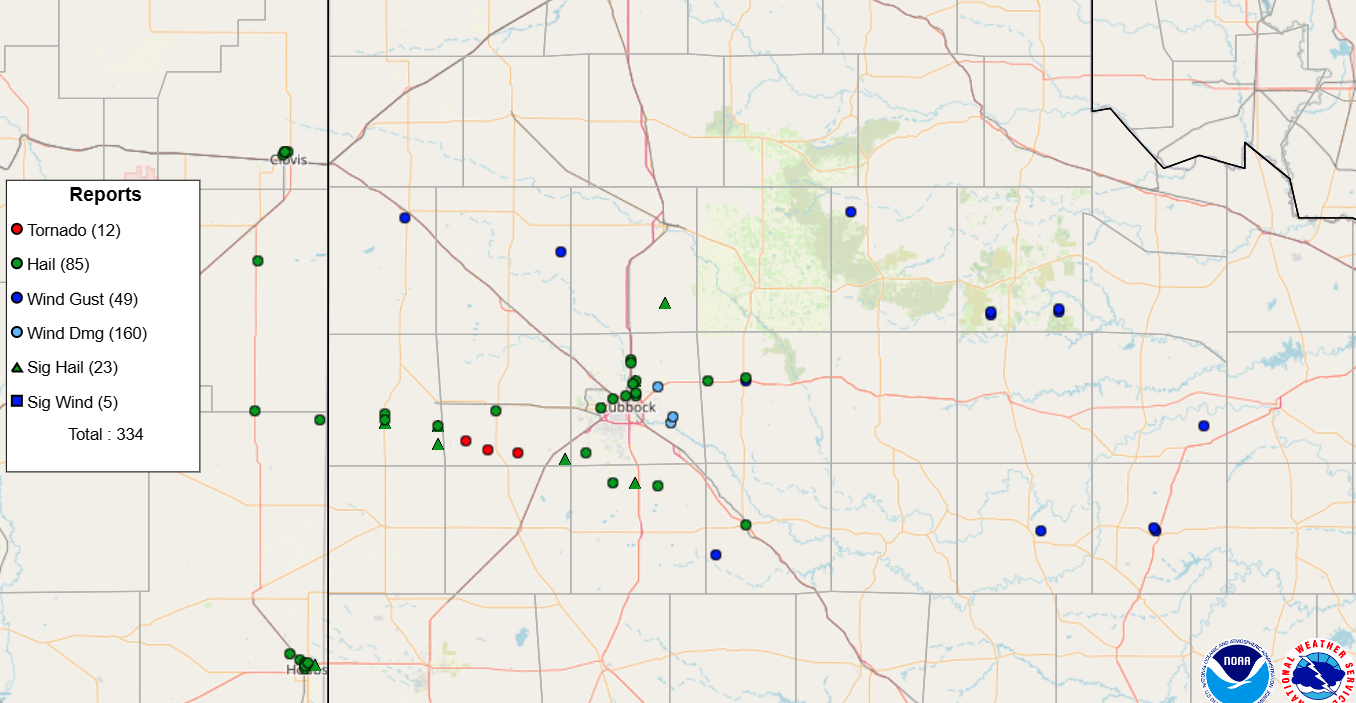
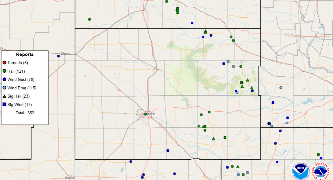
| The below graphic shows the location of the storm reports collected by the National Weather Service (NWS) Friday afternoon through early Saturday. | |
 |
|
| Plot of the preliminary storm reports collected on Friday, 6 June 2025. | |
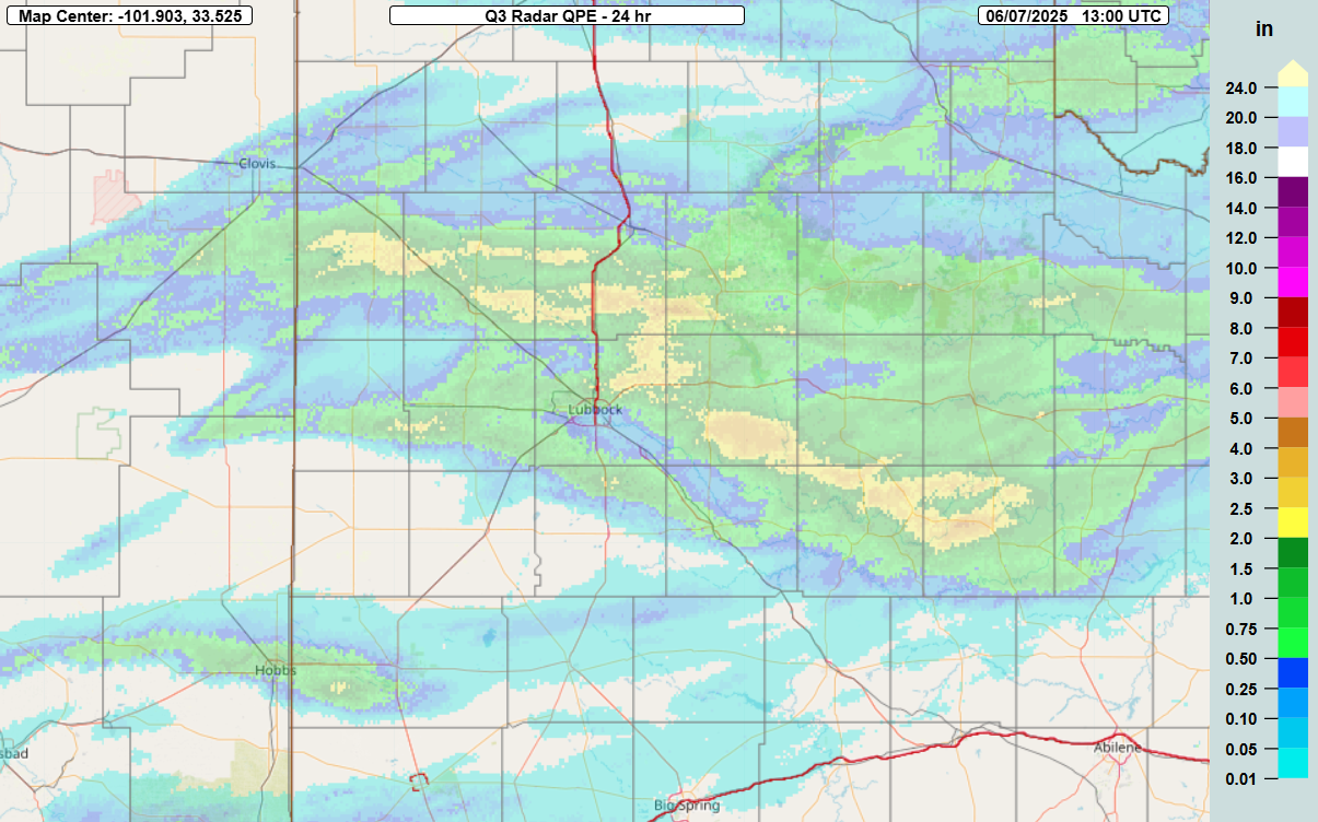
| Not to be forgotten, the severe thunderstorms also dropped torrential rain as they moved through. The heaviest rain, from 1 to 2+ inches, affects parts of the northern and northeastern South Plains into the central and southern Rolling Plains. Several reports of street flooding were received, including near New Deal, Wilson, Post and White River Lake. | |
 |
|
| Multi-Radar Multi-Sensor (MRMS) 24-hr rainfall ending at 8 am on Saturday (7 June 2025). | |
| After a brief lull in activity during the day Saturday and Saturday evening (7 June), the weather again turned unsettled late Saturday night as a convectively-aided cold front moved in from the north. One intense storm advanced into the south-central Texas Panhandle around 3 am, generating a wind gust to 60 mph as it traversed the WTM site north of Hart. This complex of storms weakened shortly thereafter as it moved over the southeast Texas Panhandle. However, the front triggered additional storm development father south, across the northern South Plains, around 5 am. This activity moved southeastward and produced golf ball sized hail in Lorenzo and a wind gust to 59 at the WTM site northwest of White River Lake before sunrise Sunday (8 June). | |
 |
|
| Supercell storm approaching Cee Vee on Sunday evening (8 June 2025). The picture is courtesy of Bruce Haynie. | |
| The early-morning thunderstorms served as a prelude to what was in store for later in the day. Strong daytime heating and rich moisture, in combination with a returning warm front and eastward moving dryline, fueled explosive thunderstorm development Sunday afternoon. The most intense activity, including supercells, took aim at the southeast Texas Panhandle and parts of the Rolling Plains, where damaging winds and large hail were observed Sunday afternoon and evening. | |
 |
|
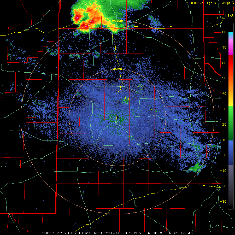
| LBB WSR-88D radar animation valid from 4:30 pm to 9:56 pm on Sunday (8 June 2025). An additional radar animation, valid from 1:43 am to 6:18 am on Sunday, can be VIEWED HERE. A regional radar animation, valid from 1:05 pm on Sunday to 6:15 am on Monday (8-9 June), can be FOUND HERE. A visible satellite animation, valid from 3:01 pm to 8:11 pm on Sunday, can be VIEWED HERE. | |
| Numerous severe wind gusts, including several in excess of 70 mph, were measured by the WTM on Sunday. A peak gust of 84 mph was recorded by the Canyon WTM with the early morning storms, and another gust to 83 mph was sampled by the JA Ranch WTM with the afternoon activity. In addition, a NSSL research team measured a wind gust of 90 mph in Lesley. | |
 |
|
| Peak wind gust measured by the West Texas Mesonet (WTM) early Sunday (8 June 2025). | |
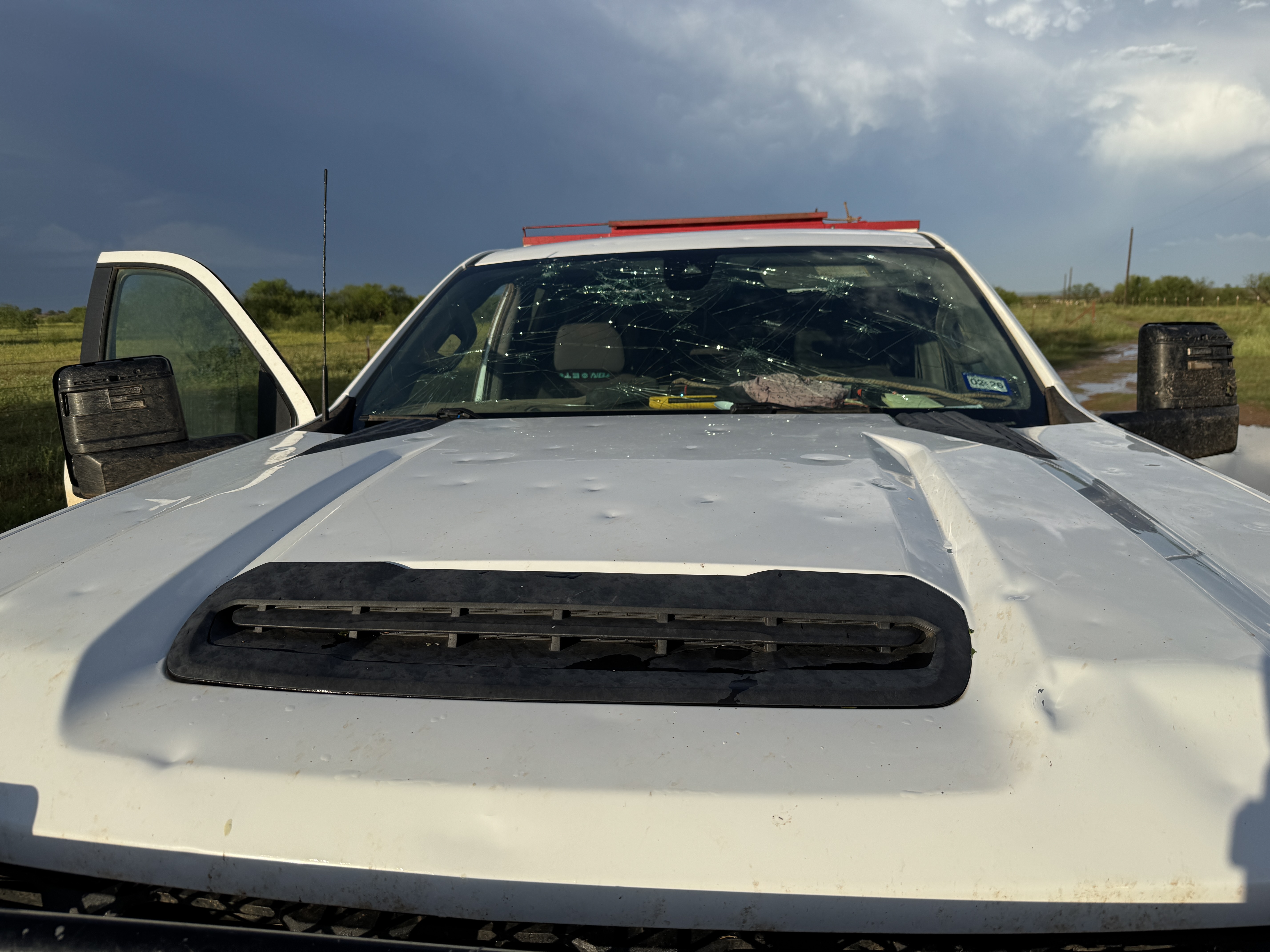
| The intense winds were even more damaging when coupled with large hail. Wind-driven golf ball size hail caused significant property damage to vehicles and structures, as seen in the pictures below from east of Paducah. | |
 |
|
 |
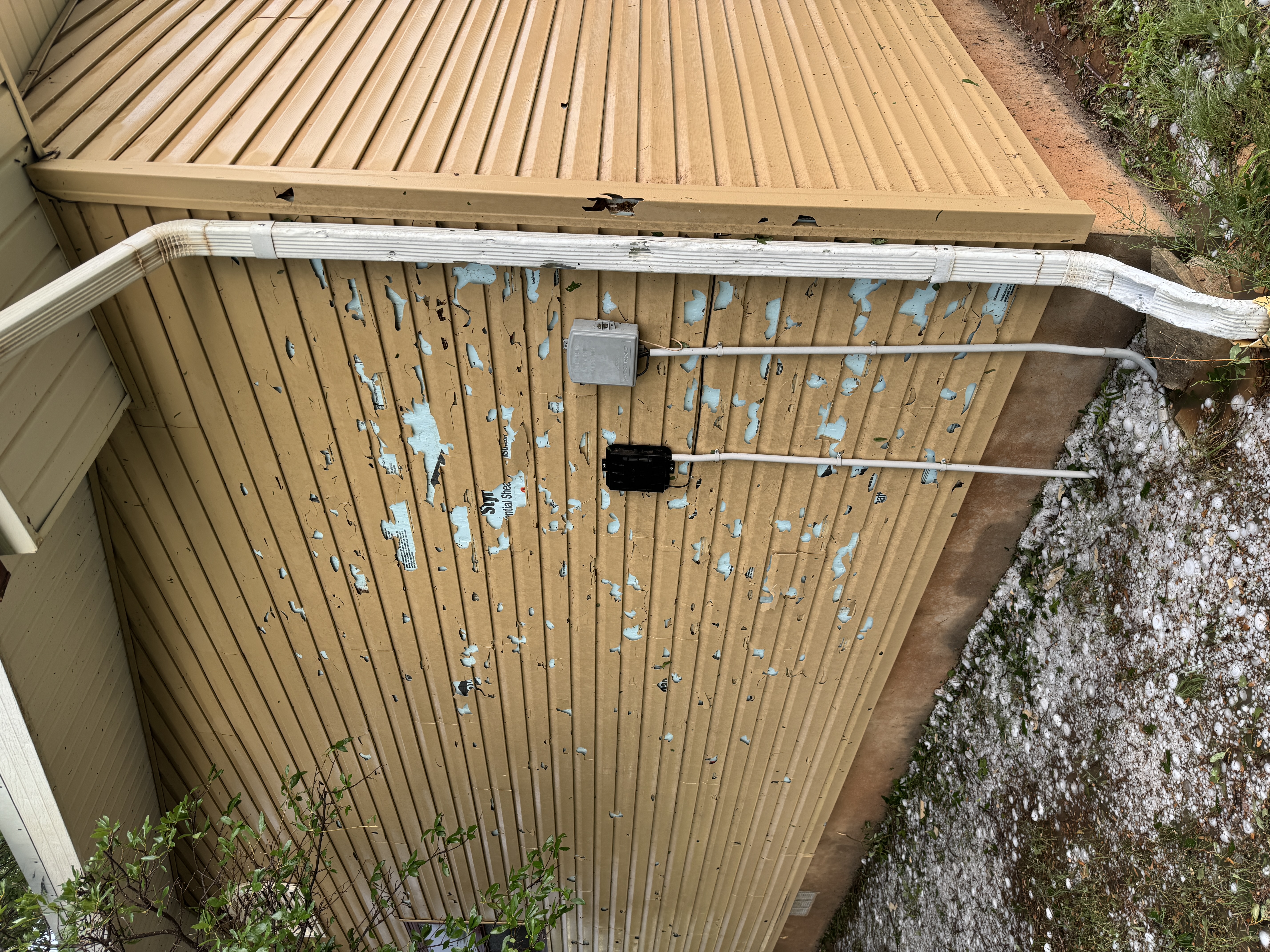 |
| Pictures of hail and wind-driven hail damage incurred on Sunday evening (8 June 2025) about 7 miles east of Paducah. The pictures are courtesy of Dana Wright. | |
|
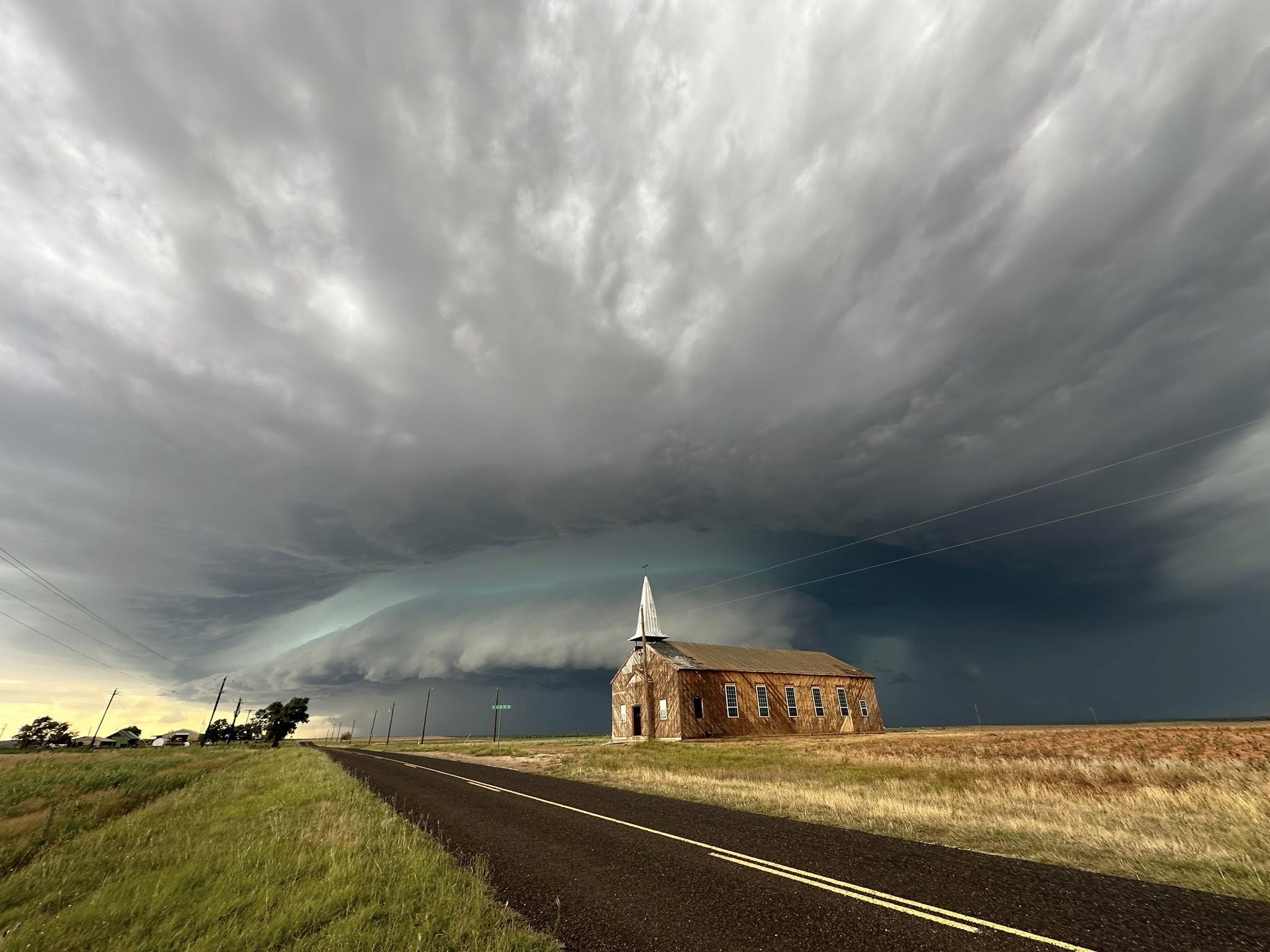
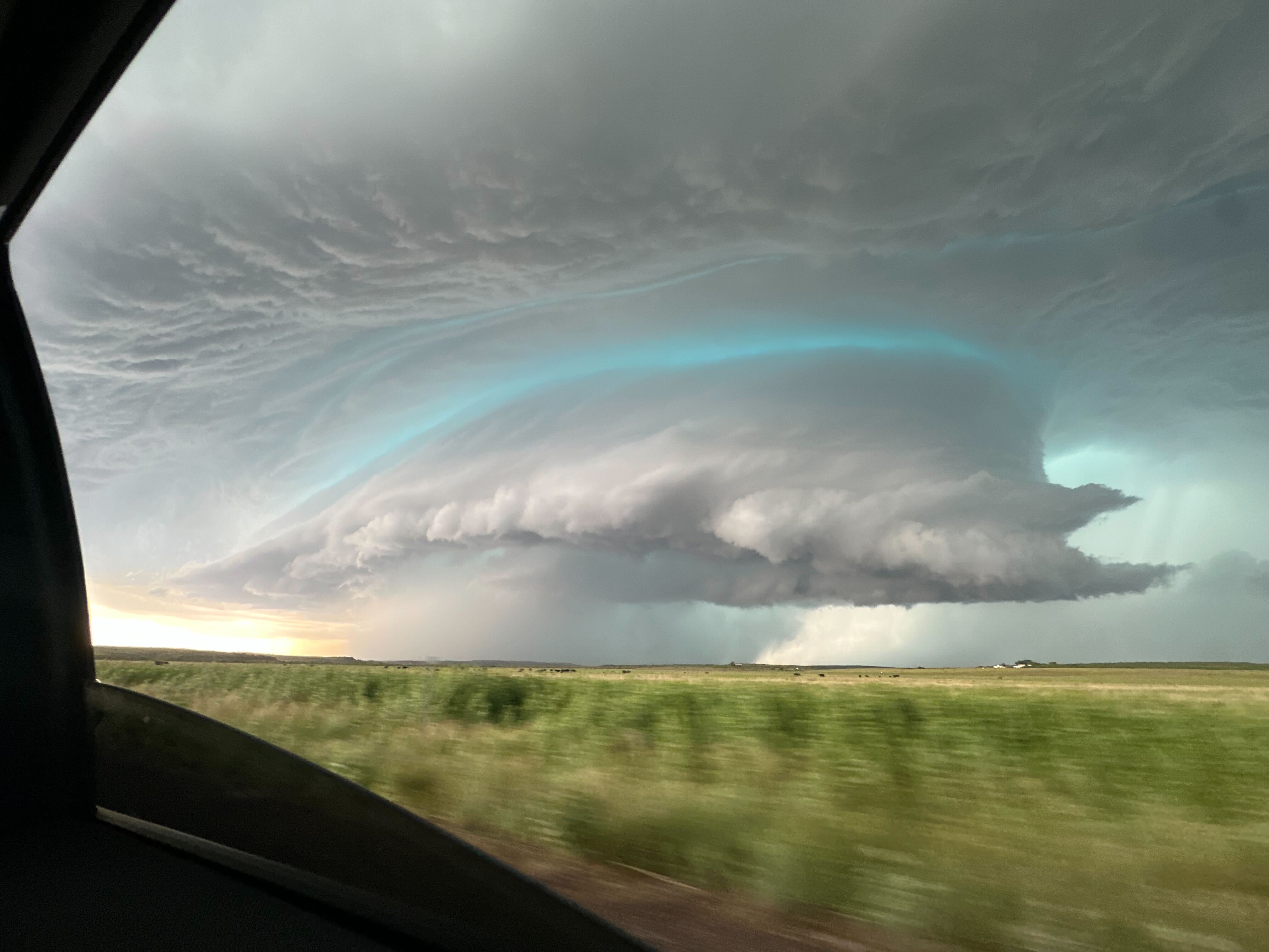
In advance of the wind, hail and torrential rain, the thunderstorms created quite an ominous sight as they approached, as the below image illustrates. A classic bell-shaped base, along with the green hue often associated with hail, was clear with this supercell thunderstorm as it moved across the southeast Texas Panhandle Sunday evening. |
|
 |
|
| Picturesque supercell thunderstorm over parts of Briscoe and Hall Counties Sunday evening (8 June 2025). The image is courtesy of Maria Pasillas | |
| The bulk of the severe weather on Sunday targeted locations off the Caprock, as the below graphic shows. | |
 |
|
| Plot of the preliminary storm reports collected on Sunday, 8 June 2025. | |
| Residual showers and thunderstorms, lingering from Sunday's activity, persisted into early Monday morning before finally shifting southeast of the area and dissipating around daybreak. Quite weather followed during the day Monday (9 June) as cooler air invaded the region behind a modest mid-June cold front. Similar to the past few days, the break didn't last long, though. | |
 |
|
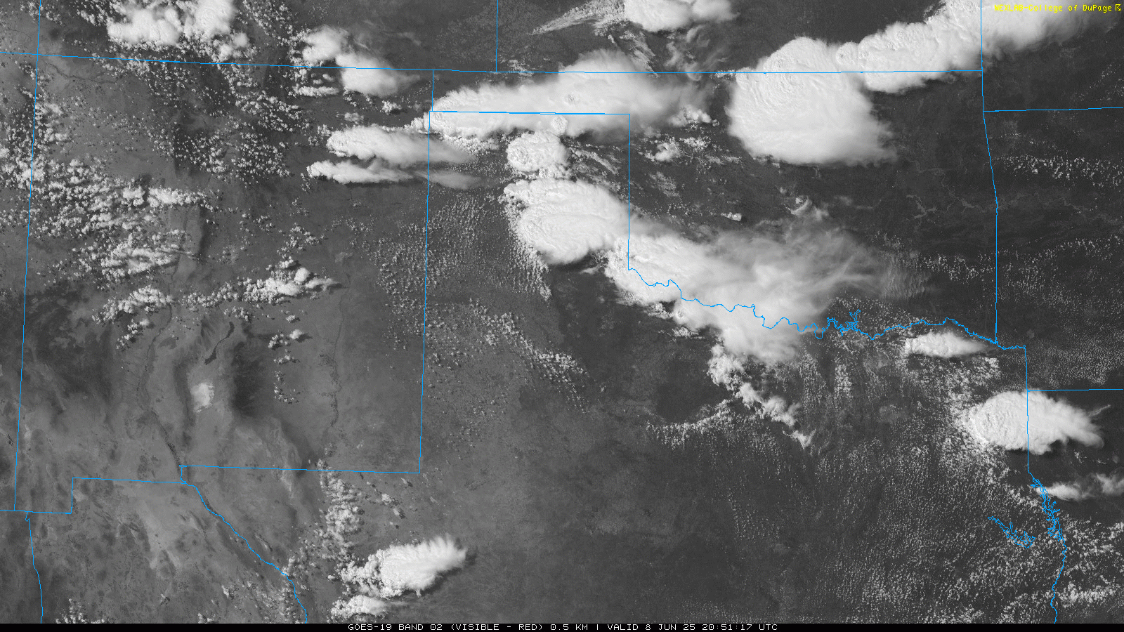
| Infrared satellite loop valid from 5:11 pm to 10:01 pm on Monday (9 June 2025). A "RGB-True Color" satellite animation, valid from 2 pm to 7:56 pm on Monday, can be VIEWED HERE. | |
|
Numerous thunderstorms formed over the higher terrain of New Mexico, as well as along the frontal zone from the Permian Basin into the Concho Valley, Monday afternoon. The former grew upscale into a complex of thunderstorms that propagated east-southeastward across the plains of eastern New Mexico and through much of the South Plains and Rolling Plains late Monday evening into early Tuesday morning. |
|
 |
|
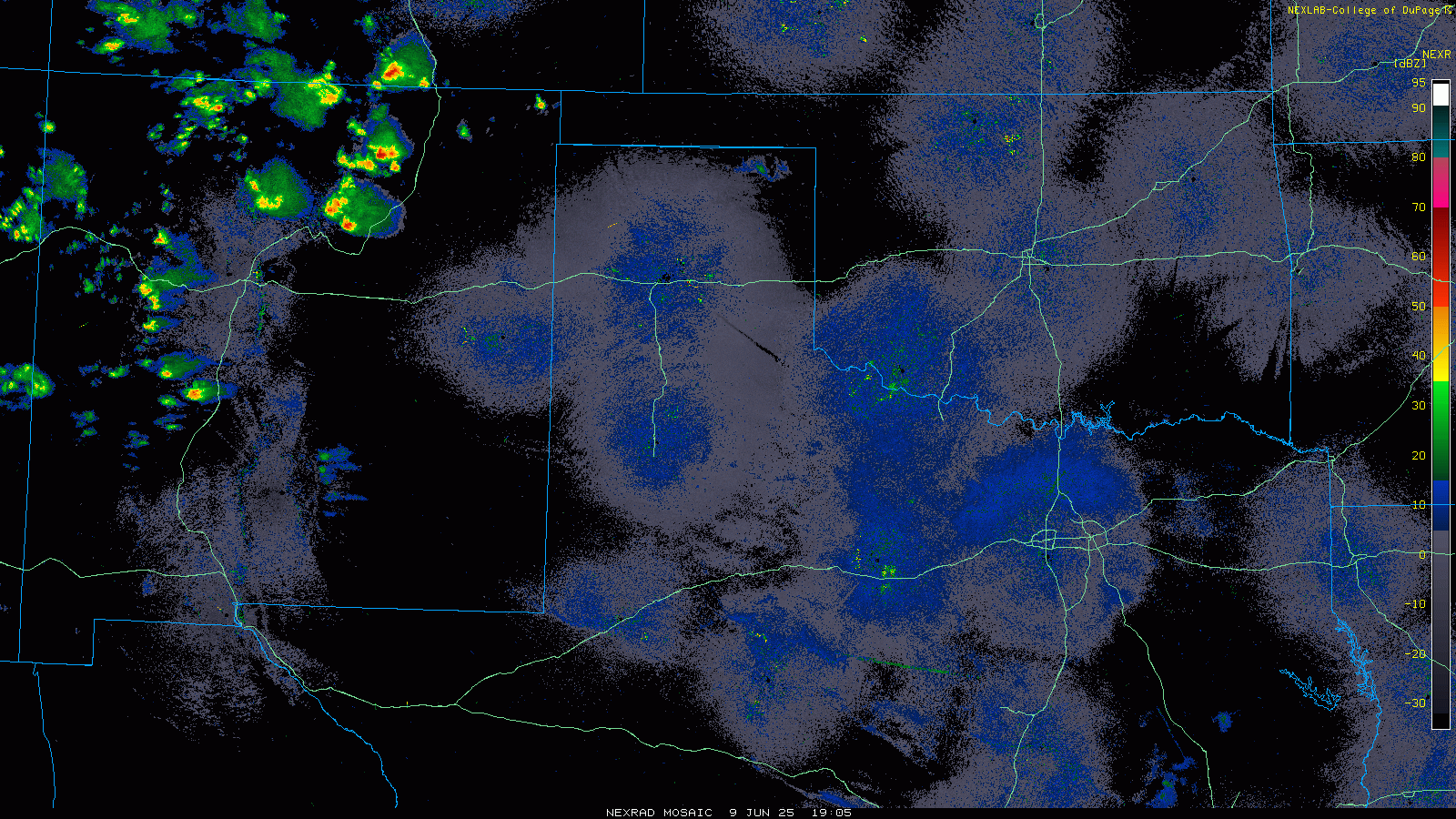
| LBB WSR-88D radar animation valid from 8:41 pm on Monday to 6:51 am on Tuesday (9-10 June 2025). A regional radar animation, valid from 2:05 pm to 10:05 pm on Monday, can be FOUND HERE. | |
| Heavy rain, gusty winds and small hail accompanied the more intense overnight activity as it traversed northwest Texas. A couple of instances of low-end severe weather, in the form of 1 inch diameter hail in Tokio and a 58 mph wind gust at the Lubbock Airport, occurred shortly afternoon midnight early Monday morning (10 June). | |
 |
|
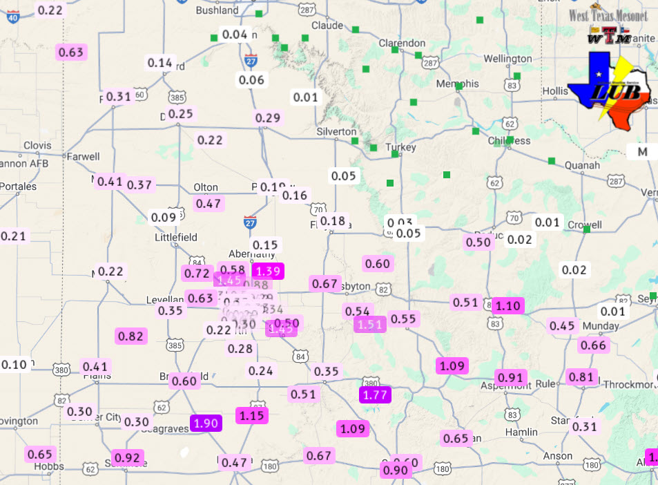
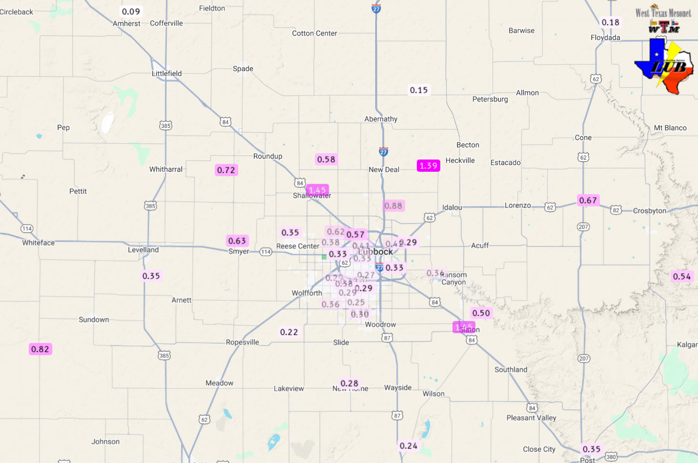
| 24-hour rainfall measured by the West Texas Mesonet (WTM), ending at 7 am on Tuesday (10 June 2025). A closeup of the Lubbock area can be ACCESSED HERE. | |
|
The more widespread impact from the overnight thunderstorms was the rain, which brought 0.50 to 1.5+ inches of rain to a good chunk of the central and southern South Plains and southern Rolling Plains. Over the course of this active stretch the Lubbock Airport officially measured 5.78 inches from the 5th through the 10th of June! Runoff from the rain caused flooding in spots, but it also raised area reservoir levels by several feet. A list of the preliminary storm reports collected over this active early to mid-June stretch can be found below. |
|
Preliminary Local Storm Report...Summary
National Weather Service Lubbock TX
357 AM CDT Sat Jun 7 2025

..TIME...   ...EVENT...      ...CITY LOCATION...     ...LAT.LON...
..DATE...   ....MAG....      ..COUNTY LOCATION..ST.. ...SOURCE....
            ..REMARKS..

0457 PM     Hail             5 NW Lubbock            33.63N 101.90W
06/06/2025  E0.75 Inch       Lubbock            TX   Public


0506 PM     Hail             1 W Lubbock Int. Airpor 33.66N 101.83W
06/06/2025  E0.75 Inch       Lubbock            TX   Public

            Report from mPING: Dime (0.75 in.).

0510 PM     Hail             3 NNW Lubbock           33.62N 101.86W
06/06/2025  M1.00 Inch       Lubbock            TX   Public


0519 PM     Hail             4 WNW Lubbock           33.61N 101.91W
06/06/2025  E1.75 Inch       Lubbock            TX   Public


0520 PM     Hail             1 NNW Lubbock Int. Airp 33.67N 101.82W
06/06/2025  M1.25 Inch       Lubbock            TX   Other Federal


0530 PM     Hail             2 S Lubbock Int. Airpor 33.62N 101.82W
06/06/2025  M1.50 Inch       Lubbock            TX   Emergency Mngr


0532 PM     Hail             New Deal                33.74N 101.84W
06/06/2025  E1.75 Inch       Lubbock            TX   Public


0535 PM     Hail             2 SW Lubbock Int. Airpo 33.63N 101.82W
06/06/2025  E0.75 Inch       Lubbock            TX   Public

            Report from mPING: Dime (0.75 in.).

0537 PM     Hail             2 SW Lubbock Int. Airpo 33.63N 101.82W
06/06/2025  E1.00 Inch       Lubbock            TX   Public

            Report from mPING: Quarter (1.00 in.).

0539 PM     Hail             1 W Lubbock Int. Airpor 33.66N 101.83W
06/06/2025  E1.00 Inch       Lubbock            TX   Public

            Report from mPING: Quarter (1.00 in.).

0540 PM     Hail             4 SW Bledsoe            33.57N 103.05W
06/06/2025  E0.75 Inch       Cochran            TX   Public

            Report from mPING: Dime (0.75 in.).

0542 PM     Hail             1 NNW Lubbock Int. Airp 33.67N 101.82W
06/06/2025  M2.00 Inch       Lubbock            TX   Other Federal


0545 PM     Tstm Wnd Dmg     3 WSW Idalou            33.65N 101.73W
06/06/2025                   Lubbock            TX   Fire Dept/Rescue

            Overturned tractor trailer.

0605 PM     Hail             12 S Morton             33.56N 102.82W
06/06/2025  E1.00 Inch       Cochran            TX   Public

            Report from mPING: Quarter (1.00 in.).

0607 PM     Tstm Wnd Dmg     Ransom Canyon           33.53N 101.68W
06/06/2025                   Lubbock            TX   Fire Dept/Rescue

            Large trees down. Blown out windows.

0610 PM     Hail             13 SE Bledsoe           33.53N 102.82W
06/06/2025  E2.75 Inch       Cochran            TX   Public

            Report from mPING: Baseball (2.75 in.).

0613 PM     Hail             13 SE Bledsoe           33.54N 102.82W
06/06/2025  E1.75 Inch       Cochran            TX   Public

            Report from mPING: Golf Ball (1.75 in.).

0617 PM     Tstm Wnd Dmg     1 NNE Ransom Canyon     33.55N 101.67W
06/06/2025                   Lubbock            TX   Fire Dept/Rescue

            3 power poles down.

0619 PM     Hail             13 SE Bledsoe           33.53N 102.82W
06/06/2025  E2.50 Inch       Cochran            TX   Public

            Report from mPING: Tennis Ball (2.50 in.).

0643 PM     Hail             6 S Whiteface           33.52N 102.61W
06/06/2025  M1.50 Inch       Cochran            TX   Public

            Report from mPING: Ping Pong Ball (1.50
            in.).

0650 PM     Hail             6 S Whiteface           33.52N 102.61W
06/06/2025  E2.00 Inch       Cochran            TX   Public

            Report from mPING: Hen Egg (2.00 in.).

0704 PM     Tornado          1 NNW Sundown           33.47N 102.50W
06/06/2025                   Hockley            TX   Trained Spotter


0704 PM     Hail             7 W Sundown             33.46N 102.61W
06/06/2025  E2.50 Inch       Cochran            TX   Public

            Report from mPING: Tennis Ball (2.50 in.).

0720 PM     Tornado          5 ESE Sundown           33.44N 102.41W
06/06/2025                   Hockley            TX   Trained Spotter


0725 PM     Hail             1 SW Levelland          33.57N 102.38W
06/06/2025  E1.75 Inch       Hockley            TX   Public

            Intersection of HWY 385 and Sandalwood Lane.

0732 PM     Tornado          8 W Ropesville          33.43N 102.29W
06/06/2025                   Hockley            TX   Trained Spotter


0743 PM     Hail             3 E Ropesville          33.41N 102.10W
06/06/2025  M2.00 Inch       Hockley            TX   Public


0750 PM     Hail             5 S Wolfforth           33.43N 102.02W
06/06/2025  E1.00 Inch       Lubbock            TX   NWS Employee


0757 PM     Tstm Wnd Gst     5 SSW Graham            33.09N 101.50W
06/06/2025  M61 MPH          Garza              TX   Mesonet

            West Texas Mesonet Report.

0812 PM     Hail             New Home                33.33N 101.91W
06/06/2025  M1.75 Inch       Lynn               TX   Emergency Mngr


0822 PM     Non-Tstm Wnd Gst 7 ESE Silverton         34.43N 101.19W
06/06/2025  M63 MPH          Briscoe            TX   Mesonet

            West Texas Mesonet Report.

0832 PM     Hail             5 W Wilson              33.33N 101.82W
06/06/2025  E3.25 Inch       Lynn               TX   Public

            Report from mPING: Baseball+ (3.25 in.).

0834 PM     Tstm Wnd Gst     New Home                33.33N 101.91W
06/06/2025  M80 MPH          Lynn               TX   Mesonet

            West Texas Mesonet Alert.

0841 PM     Non-Tstm Wnd Gst 2 WSW Turkey            34.38N 100.93W
06/06/2025  M61 MPH          Hall               TX   Mesonet

            West Texas Mesonet Report.

0842 PM     Hail             New Deal                33.73N 101.84W
06/06/2025  M1.00 Inch       Lubbock            TX   Emergency Mngr

            New Deal Fire Station.

0842 PM     Flood            3 E New Home            33.33N 101.86W
06/06/2025                   Lynn               TX   Public

            Report from mPING: Street/road flooding;
            Street/road closed; Vehicles stranded.

0844 PM     Flood            2 E New Home            33.33N 101.88W
06/06/2025                   Lynn               TX   Public

            Report from mPING: Street/road flooding;
            Street/road closed; Vehicles stranded.

0847 PM     Hail             Wilson                  33.32N 101.73W
06/06/2025  E1.50 Inch       Lynn               TX   Emergency Mngr

            Picture from EM.

0910 PM     Flash Flood      Wilson                  33.32N 101.72W
06/06/2025                   Lynn               TX   Public

            Report from mPING: Street/road flooding;
            Street/road closed; Vehicles stranded.

0918 PM     Hail             1 N Post                33.20N 101.38W
06/06/2025  E0.75 Inch       Garza              TX   Public

            Report from mPING: Dime (0.75 in.).

0922 PM     Hail             Lorenzo                 33.67N 101.53W
06/06/2025  E1.75 Inch       Crosby             TX   Emergency Mngr


0924 PM     Hail             Post                    33.19N 101.38W
06/06/2025  E1.75 Inch       Garza              TX   Public

            Picture from social media.

0927 PM     Flash Flood      Post                    33.19N 101.38W
06/06/2025                   Garza              TX   Public

            Report from mPING: Street/road flooding;
            Street/road closed; Vehicles stranded.

0929 PM     Flash Flood      1 N Post                33.20N 101.38W
06/06/2025                   Garza              TX   Public

            Report from mPING: Street/road flooding;
            Street/road closed; Vehicles stranded.

0933 PM     Flood            5 W Wilson              33.33N 101.81W
06/06/2025                   Lynn               TX   Emergency Mngr

            Pictures show road completely covered in
            water.

0935 PM     Hail             Ralls                   33.68N 101.38W
06/06/2025  M1.75 Inch       Crosby             TX   Emergency Mngr


0936 PM     Tstm Wnd Gst     1 SE Ralls              33.67N 101.38W
06/06/2025  M62 MPH          Crosby             TX   Mesonet


0937 PM     Tstm Wnd Gst     3 NE Aspermont          33.17N 100.20W
06/06/2025  E68 MPH          Stonewall          TX   Mesonet


0942 PM     Flash Flood      Post                    33.19N 101.38W
06/06/2025                   Garza              TX   Public

            Report from mPING: Street/road flooding;
            Street/road closed; Vehicles stranded.

0946 PM     Hail             7 NW Aspermont          33.21N 100.31W
06/06/2025  M0.75 Inch       Stonewall          TX   Public

            Report from mPING: Dime (0.75 in.).

1000 PM     Hail             1 ENE Reese Center      33.60N 102.01W
06/06/2025  E0.70 Inch       Lubbock            TX   Fire Dept/Rescue


1001 PM     Hail             4 E Reese Center        33.58N 101.95W
06/06/2025  E0.75 Inch       Lubbock            TX   Public

            Report from mPING: Dime (0.75 in.).

1002 PM     Hail             4 ESE Reese Center      33.58N 101.96W
06/06/2025  E1.00 Inch       Lubbock            TX   Public


1041 PM     Flash Flood      3 S White River Lake    33.44N 101.10W
06/06/2025                   Crosby             TX   Public

            Report from mPING: Street/road flooding;
            Street/road closed; Vehicles stranded.

1100 PM     Tstm Wnd Gst     8 NW Grow               33.89N 100.40W
06/06/2025  M62 MPH          Cottle             TX   Mesonet

            Mesonet station 36 Paducah 10SW.

1122 PM     Tstm Wnd Gst     6 S Olton               34.10N 102.12W
06/06/2025  E65 MPH          Lamb               TX   Mesonet

            West Texas Mesont.

1149 PM     Tstm Wnd Gst     2 SSE Hackberry         33.90N 100.13W
06/06/2025  M61 MPH          Cottle             TX   Mesonet

            Mesonet station 117 2SSE Hackberry
            Hackberry/Cottle County.

0105 AM     Tstm Wnd Gst     2 ENE Flomot            34.23N 100.96W
06/07/2025  M64 MPH          Motley             TX   Mesonet

            West Texas Mesonet.

0109 AM     Tstm Wnd Gst     1 SW Muleshoe           34.21N 102.74W
06/07/2025  M65 MPH          Bailey             TX   Public

            Also gusted to 64 mph at 110 AM. West Texas
            Mesonet.

0122 AM     Non-Tstm Wnd Gst 1 SSW Northfield        34.28N 100.60W
06/07/2025  M59 MPH          Motley             TX   Mesonet

            West Texas Mesonet. Gust occurred well away
            from storms.

0153 AM     Tstm Wnd Gst     8 NW Grow               33.90N 100.40W
06/07/2025  M60 MPH          Cottle             TX   Mesonet

            West Texas Mesonet.

0158 AM     Hail             7 NW Petersburg         33.93N 101.70W
06/07/2025  E2.50 Inch       Hale               TX   Trained Spotter

            2-inch hail measured two hours after storm.
            Estimated between 2.25 and 2.5 inches before
            melting. Time estimated.

0215 AM     Tstm Wnd Gst     2 SE Hackberry          33.91N 100.13W
06/07/2025  M73 MPH          Cottle             TX   Mesonet

            Also gusted to 59 mph at 214 AM. West Texas
            Mesonet.
Preliminary Local Storm Report...Summary
National Weather Service Lubbock TX
1248 AM CDT Mon Jun 9 2025

..TIME...   ...EVENT...      ...CITY LOCATION...     ...LAT.LON...
..DATE...   ....MAG....      ..COUNTY LOCATION..ST.. ...SOURCE....
            ..REMARKS..

0301 AM     Tstm Wnd Gst     3 N Hart                34.42N 102.11W
06/08/2025  M60 MPH          Castro             TX   Mesonet


0548 AM     Hail             Lorenzo                 33.67N 101.53W
06/08/2025  E1.75 Inch       Crosby             TX   Public

            Report from mPING: Golf Ball (1.75 in.).

0550 AM     Hail             Lorenzo                 33.67N 101.53W
06/08/2025  E1.75 Inch       Crosby             TX   Trained Spotter


0617 AM     Tstm Wnd Gst     5 NW White River Lake   33.53N 101.17W
06/08/2025  M59 MPH          Crosby             TX   Mesonet

            West Texas Mesonet.

0241 PM     Hail             6 NW Estelline          34.63N 100.48W
06/08/2025  E1.25 Inch       Hall               TX   Public

            Report from mPING: Half Dollar (1.25 in.).

0246 PM     Hail             2 N Estelline           34.58N 100.44W
06/08/2025  E1.00 Inch       Hall               TX   Public

            Report from mPING: Quarter (1.00 in.).

0320 PM     Hail             10 SW Wellington        34.72N 100.30W
06/08/2025  E0.75 Inch       Childress          TX   Public

            Report from mPING: Dime (0.75 in.).

0509 PM     Tstm Wnd Gst     14 W Lakeview           34.63N 100.94W
06/08/2025  M90 MPH          Hall               TX   Trained Spotter

            NSSL team measured a 90 mph wind gust with
            their mobile mesonet. The winds overturned a
            center pivot near this location.

0510 PM     Hail             12 WNW Lakeview         34.71N 100.90W
06/08/2025  M2.00 Inch       Hall               TX   Public

            2.2 inch hail measured by ICECHIP. Time of
            hail is estimated.

0513 PM     Hail             11 W Lakeview           34.69N 100.90W
06/08/2025  M1.75 Inch       Hall               TX   Public

            Report from mPING: Golf Ball (1.75 in.).

0519 PM     Hail             12 W Lakeview           34.71N 100.90W
06/08/2025  M2.00 Inch       Hall               TX   Public

            Report from mPING: Hen Egg (2.00 in.).

0521 PM     Tstm Wnd Gst     2 S Lesley              34.65N 100.81W
06/08/2025  M68 MPH          Hall               TX   Mesonet

            West Texas Mesonet. Also measured a gust to
            59 mph at 5:22 PM.

0551 PM     Tstm Wnd Gst     1 S Northfield          34.27N 100.60W
06/08/2025  M64 MPH          Motley             TX   Mesonet

            Measured by the West Texas Mesonet. Another
            gust to 60 mph was measured at 5:53 PM.

0600 PM     Tstm Wnd Dmg     Cee Vee                 34.23N 100.44W
06/08/2025                   Cottle             TX   Storm Chaser

            Steeple of church blown off. Time of damage
            estimated.

0600 PM     Tstm Wnd Dmg     4 ENE Northfield        34.30N 100.53W
06/08/2025                   Motley             TX   Storm Chaser

            Power pole bent over the roadway. Lines
            still attached, hanging at about 6 to 7 feet
            above the roadway. Time is when the report
            came in. Damage may have occurred earlier.

0614 PM     Hail             7 E Cee Vee             34.23N 100.32W
06/08/2025  E1.75 Inch       Cottle             TX   Public

            Hail as large as golf balls falling
            currently.

0624 PM     Hail             1 SW Dickens            33.61N 100.84W
06/08/2025  E1.25 Inch       Dickens            TX   Public

            Report from mPING: Half Dollar (1.25 in.).

0625 PM     Tstm Wnd Dmg     Paducah                 34.01N 100.30W
06/08/2025                   Cottle             TX   Broadcast Media

            Picture of large tree limbs down in Paducah.
            Time of damage estimated.

0630 PM     Hail             6 SE White River Lake   33.42N 101.01W
06/08/2025  M2.50 Inch       Dickens            TX   Trained Spotter

            Pictures of hail as large as 2.5 inches in
            diameter. Time of hail fall is estimated.

0632 PM     Hail             1 SW Paducah            34.01N 100.31W
06/08/2025  E1.00 Inch       Cottle             TX   Public

            Report from mPING: Quarter (1.00 in.).

0633 PM     Tstm Wnd Gst     10 SW Paducah           33.89N 100.40W
06/08/2025  M77 MPH          Cottle             TX   Mesonet

            Peak wind gust measured by the West Texas
            Mesonet. Gusts of 60 mph or greater occurred
            between 6:32 and 6:37 PM.

0635 PM     Hail             4 S Paducah             33.96N 100.30W
06/08/2025  E2.50 Inch       Cottle             TX   Storm Chaser


0635 PM     Tstm Wnd Dmg     10 S Paducah            33.88N 100.38W
06/08/2025                   Cottle             TX   CO-OP Observer

            Wind and dirt blew very intensely. The winds
            caused tree damage and blew in the north
            side of a large shed some. Time damage
            occurred is estimated.

0635 PM     Hail             9 NW Spur               33.57N 100.97W
06/08/2025  M1.75 Inch       Dickens            TX   Storm Chaser

            Time of hail estimated.

0635 PM     Hail             6 ENE Paducah           34.05N 100.21W
06/08/2025  M2.00 Inch       Cottle             TX   Public

            Picture of 2.069 inch diameter hail
            precisely measured. Time of hail is
            estimated.

0635 PM     Hail             1 SW Paducah            34.01N 100.31W
06/08/2025  E1.00 Inch       Cottle             TX   Public

            Report from mPING: Quarter (1.00 in.).

0637 PM     Hail             1 SW Paducah            34.01N 100.31W
06/08/2025  E1.25 Inch       Cottle             TX   Public

            Report from mPING: Half Dollar (1.25 in.).

0638 PM     Hail             6 SW Spur               33.41N 100.91W
06/08/2025  E1.75 Inch       Dickens            TX   Storm Chaser

            Picture of hail from social media. Time of
            hail fall estimated.

0640 PM     Hail             9 SW Spur               33.36N 100.91W
06/08/2025  M1.75 Inch       Kent               TX   Public

            Report from mPING: Golf Ball (1.75 in.).

0645 PM     Hail             1 NE Hackberry          33.94N 100.14W
06/08/2025  E2.00 Inch       Cottle             TX   Broadcast Media

            Time of hail fall estimated.

0646 PM     Hail             7 SW Spur               33.41N 100.94W
06/08/2025  E2.00 Inch       Dickens            TX   Trained Spotter

            Time of hail estimated.

0646 PM     Tstm Wnd Gst     2 SSE Hackberry         33.90N 100.13W
06/08/2025  M72 MPH          Cottle             TX   Mesonet

            Peak wind gust measured by the West Texas
            Mesonet. Additional gusts of 58 mph or
            greater occurred between 6:43 and 6:50 pm.

0654 PM     Hail             6 SW Spur               33.41N 100.91W
06/08/2025  E1.25 Inch       Dickens            TX   Public

            Report from mPING: Half Dollar (1.25 in.).

0713 PM     Funnel Cloud     3 N Clairemont          33.21N 100.75W
06/08/2025                   Kent               TX   Trained Spotter

            Brief funnel observed with storm in Kent
            County. Funnel has since dissipated.
            Location is estimate from radar.

0718 PM     Hail             6 N Clairemont          33.25N 100.77W
06/08/2025  M2.00 Inch       Kent               TX   Public

            Report from mPING: Hen Egg (2.00 in.).

0730 PM     Hail             1 NW Jayton             33.26N 100.58W
06/08/2025  E1.25 Inch       Kent               TX   Public

            Report from mPING: Half Dollar (1.25 in.).

0752 PM     Tstm Wnd Gst     1 S Northfield          34.27N 100.60W
06/08/2025  M65 MPH          Motley             TX   Mesonet

            Peak wind gust measured by the West Texas
            Mesonet with this round of storms.
            Additional gusts of 59 mph or greater
            occurred at 7:51 and 7:53 pm.

0829 PM     Hail             1 NW Jayton             33.26N 100.58W
06/08/2025  E1.00 Inch       Kent               TX   Public

            Report from mPING: Quarter (1.00 in.).

0936 PM     Hail             2 W Lubbock             33.58N 101.89W
06/08/2025  E1.00 Inch       Lubbock            TX   Public

            Report from mPING: Quarter (1.00 in.).

0957 PM     Tstm Wnd Gst     5 SSW Graham            33.08N 101.52W
06/08/2025  M60 MPH          Garza              TX   Mesonet


1007 PM     Tstm Wnd Gst     5 SSW Graham            33.08N 101.52W
06/08/2025  M65 MPH          Garza              TX   Mesonet


1033 PM     Tstm Wnd Gst     5 SSW Graham            33.08N 101.52W
06/08/2025  M67 MPH          Garza              TX   Mesonet


0412 AM     Hail             3 SW Lubbock            33.56N 101.89W
06/09/2025  E0.75 Inch       Lubbock            TX   Public

            Report from mPING: Dime (0.75 in.).

