|
Tornadic storm, large wind-driven hail and torrential rain 5 June 2025 |
|
 |
|
|
Tornadic thunderstorm just north of Morton Thursday evening (5 June 2025). The picture is courtesy of Jesse Risley. |
|
|
Thursday, June 5th, 2025, brought two rounds of high-impact weather to West Texas, one just after midnight over the southern Texas Panhandle and then a more intense round late afternoon into the evening across the western and central South Plains. The early morning hours started with a complex of thunderstorms, storms that originated in northern New Mexico the previous day, tracking across the southern Texas Panhandle. Despite being well past sunset, rich moisture contributed to strong instability that allowed this activity to remain intense well into the overnight hours. |
|
 |
|
| LBB WSR-88D radar animation valid from 10:47 pm on Wednesday to 6:14 am on Thursday (4-5 June 2025). | |
| One particularly intense thunderstorm took aim at the south-central Texas Panhandle shortly after midnight. Damaging winds were accompanied by large hail as the storm moved over northern and central Swisher County. Power poles were downed southwest of Happy, which made traffic impassable on FM 1425 about 9 miles southwest of town. | |
 |
 |
| Pictures of damage caused by wind-driven hail in Tulia early Thursday morning (5 June 2025). The images are courtesy of Trish Hawkins, via Maria Pasillas. | |
| The storm then marched across Tulia with wind-driven golf ball sized hail, knocking out several window and shredding vegetation. The West Texas Mesonet (WTM) located 2 miles east-northeast of town measured a peak wind gust of 81 mph at 12:23 am. Thankfully, the storm weakened as it moved farther east, but additional development along the outflow-aided cold front brought widespread rain to much of the southern Texas Panhandle, northeastern South Plains and Rolling Plains. The late-night storms also provided foreshadowing for what the atmosphere would be capable of later in the day. | |
 |
|
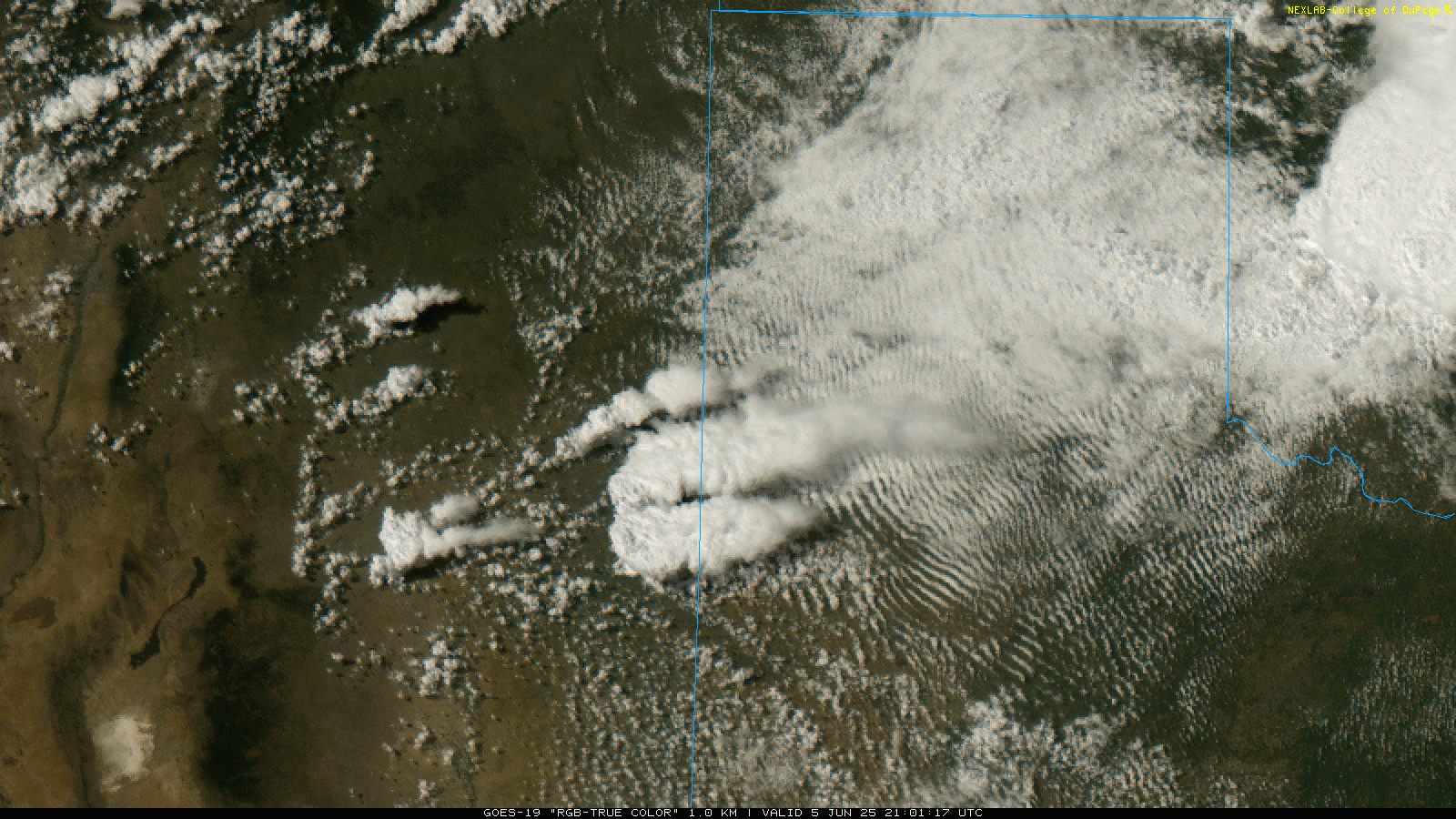
| "RGB-True Color" satellite animation valid from 4:06 pm to 5:36 pm on Thursday (5 June 2025). | |
| The effective cold front stalled in eastern New Mexico and the northern Permian Basin by early Thursday afternoon, before returning northward as a warm front late in the day. Very humid air, by West Texas standards, beneath cold air aloft, contributed to extreme instability by late in the day. Much of the day the instability was "capped" from being released thanks to the relatively cooler air behind the front. However, that quickly changed by late afternoon as explosive storm development occurred in far east-central New Mexico. | |
 |
|
| LBB WSR-88D radar animation valid from 3:26 pm to 9:48 pm on Thursday (5 June 2025). An additional animation, valid from 11:03 pm on Thursday to 6:57 am on Friday (5-6 June) can be VIEWED HERE. | |
| Strong wind shear, as a result of both the change in direction and increase in speed with height, caused the thunderstorms to quickly organize, with one storm becoming dominant in eastern New Mexico. This storm wasted little time, producing a tornado west of Lingo, NM, in open country. | |
 |
|
| Tornado observed west of Lingo, NM, late Thursday afternoon (5 June 2025). The picture is courtesy of Bruce Haynie. | |
| The tornadic thunderstorm moved steadily eastward, crossing the TX/NM line, while continuing to strongly rotate and produce tornadoes. The intense storm gradually tracked east-southeastward, taking the center of circulation over northern Cochran and Hockley Counties, before moving across central and southeastern Lubbock County. | |
 |
|
| Multi-Radar Multi-Sensor (MRMS) 6-hr low-level rotation track (1/sec) ending at 9 pm on Thursday (5 June 2025). | |
| The dominate storm produced a number of tornadoes, in addition to damaging straight-line winds, large hail, and torrential rainfall as it traversed the central South Plains. Wind gusts of 50 to 70+ mph were common with the storm, while a peak gust of 109 mph was measured by the Smyer WTM. | |
 |
|
| Peak wind gust measured by the West Texas Mesonet (WTM) on Thursday (5 June 2025). A zoomed in view of the central South Plains can be SEEN HERE. | |
| The below image shows the nearly continuous track of storm reports received from the tornadic storm as it impacted the western and central South Plains Thursday evening. This included a number of tornado reports spanning from eastern New Mexico to the western portion of Lubbock County. The tornadoes and wind-driven hail caused significant damage in a number of locations. Even the western and southwestern side of Lubbock was impacted by wind-driven hail that caused significant property and plant damage, though thankfully the storm lost some organization and stopped producing tornadoes west of town. | |
 |
|
| Plot of the preliminary storm reports collected on Thursday, 5 June 2025. | |
| Where tornadoes did occur west of Lubbock, various degrees of damage were noted by three NWS damage survey teams that were deployed the following day. | |
 |
|
| Tornadoes observed northwest of Reese Center, TX, Thursday evening (5 June 2025). The picture is courtesy of Bruce Haynie. | |
| The Reese Center area, and locations to its west and northwest, were particularly hard hit from a combination of tornadic winds and intense straight-line winds associated with the rear flank downdraft that swept across the land south of the tornado. | |
 |
|
| Destroyed manufactured home 4 miles west-northwest of Reese Center. The destruction was caused by a tornado Thursday evening (5 June). The image was collected by a NWS damage survey team the following day. | |
| The above and below images show manufactured homes that were heavily damaged and destroyed by a tornado as it moved across a development about 4 miles northwest of Reese Center. Unfortunately, at least two people were injured when their home rolled, but thankfully no one was killed. | |
 |
|
 |
 |
| Rolled manufactured home 4 miles west-northwest of Reese Center. The destruction was caused by a tornado Thursday evening (5 June). The image was collected by a NWS damage survey team the following day. | |
|
Farther west, the thunderstorm produced two larger and longer-lived tornadoes, including one that passed between Whitharral and Levelland, and another that was observed north and northwest of Morton. |
|
 |
 |
| Large wedge tornado observed northwest (left) and north (right) of Morton, TX, Thursday evening (5 June 2025). The pictures are courtesy of Bruce Haynie. | |
| Both of the larger wedge-type tornadoes were well-documented by storm chasers, as well as atmospheric science teams that were collecting data. Thankfully, these tornadoes remained over rural lands, with most of the damage observed confined to power poles and center pivots. | |
 |
 |
| Downed power poles north of Levelland (left) and Morton (right). The damage was caused by tornadoes Thursday evening (5 June). The images were collected by a NWS damage survey team the following day. | |
| The above pictures illustrate the type of damage that was found where the two wedge tornadoes tracked across portions of rural Cochran and Hockley Counties. | |
 |
|
| Downed trees at Reese Center. The damage was caused by a tornado Thursday evening (5 June). The image was collected by a NWS damage survey team the following day. | |
|
Above and below are additional pictures of damage inflicted in and near Reese Center. The Reese Golf Course lost several mature trees, while a lot of roof damage was noted in the area. Additional damage survey information (pictures and damage ratings) for this day can be viewed on the Damage Assessment Toolkit (DAT). Be sure to select the correct date range (including June 5th and 6th, at a minimum) when using the DAT to view information for this event. |
|
 |
|
| Roof damage sustained near 18th Street and Rochester Avenue about 3 miles east of Reese Center. The damage was caused by extreme straight-line winds associated with a tornadic thunderstorm Thursday evening (5 June). The image was collected by a NWS damage survey team the following day. | |
| In addition to the tornadoes and severe straight-line winds, a swath of large hail accompanied the storm. Numerous reports of golf ball to baseball size hail were received through the lifetime of the tornadic storm, with several reports of giant hail. This included a few reports of 3 inch diameter hail west of Enochs and southwest of Pep as well as a stone as large as 5 inches in diameter (larger than softballs!) 7 miles south of Anton. | |
 |
|
| Multi-Radar Multi-Sensor (MRMS) 6-hr maximum estimated hail size (mm) ending at 9 pm on Thursday (5 June 2025). | |
| Not to be forgotten, torrential rain fell from the intense thunderstorm. Excessive runoff caused flooding, including in parts of Lubbock where 1 to 2+ inches of rain fell in a short amount of time. | |
 |
|
| A flooded intersection at 98th Street and Quaker Avenue in Lubbock on Thursday evening (5 June 2025). The picture is courtesy of the City of Lubbock. | |
| Even greater rain totals were noted upstream of Lubbock, from near Shallowater westward to Enochs and Maple, where 3 to 5 inches of rain inundated the area. | |
 |
|
| Multi-Radar Multi-Sensor (MRMS) 12-hr rainfall ending at 9 pm on Thursday (5 June 2025). | |
|
A list of the preliminary storm reports collected on June 5th, as well as the Damage Survey results, can be found below. |
|
Public Information Statement
National Weather Service Lubbock TX
106 PM CDT Wed Jun 11 2025

...NWS Damage Survey for 06/05/2025 Tornado Event...

.Overview...
During the afternoon and evening hours of Thursday, June 5, 2025, an
intense supercell thunderstorm moved over the South Plains region of
West Texas, producing several tornadoes over portions of Cochran,
Hockley, and Lubbock Counties. This thunderstorm also produced
widespread damage from very strong straight-line winds and large hail
across western and southwestern portions of the City of Lubbock
before it exited into Crosby and Garza Counties and weakened late in
the evening. NWS Lubbock deployed three separate teams to survey the
damage from this thunderstorm, with the combined results of these
surveys documented in detail below.

This supercell initially produced a brief tornado over far northwestern
Cochran County that moved over open country and produced no known
damage. Shortly thereafter, the supercell produced a strong wedge-
type tornado several miles northwest of Morton, which destroyed
multiple large wooden power poles as it tracked eastward, eventually
crossing TX-214 about 4 miles north of Morton before dissipating over
northeastern Cochran County. The supercell then produced another
strong tornado over far northwestern Hockley County, about 5 miles
northwest of the community of Pettit, which was directly observed by
mobile research radar. A separate and very brief cone-type tornado
was then observed only about 2 miles north of Pettit.

The supercell then began to track more southeastward, with no
tornadoes observed for a period of approximately 15 minutes. Just as
the supercell approached US-385 in north-central Hockley County, it
produced another strong tornado which crossed US-385 about 3 miles
south of the community of Whitharral. This tornado destroyed several
additional wooden power poles, rolled a semi-truck traveling on the
highway, and damaged buildings and trees along its path before it
dissipated about 7 miles east of US-385.

The final three tornadoes produced by this supercell were observed as
the storm crossed from eastern Hockley County into western Lubbock
County. The first tornado developed approximately 3 miles northeast
of TX-114 and the community of Smyer, damaging or destroying multiple
manufactured homes as it moved eastward before it dissipated along
the Hockley/Lubbock County line. The second tornado developed very
close to the termination of the previous tornado, and damaged or
destroyed several homes and buildings as it tracked southeastward and
dissipated only about a quarter mile north of TX-114. The final
tornado produced during this event developed and tracked over
southern portions of Reese Center, toppling large trees and damaging
roofs before dissipating just outside the Lubbock city limits.

Although the storm did not produce any additional tornadoes after
this point, the supercell did continue to produce very strong
straight-line winds and large hail, which resulted in widespread
damage to homes and businesses across western and southwestern
portions of the City of Lubbock. Many buildings within the city
experienced significant damage to roofs and windows, and hail up to
the size of tennis balls was observed within the city limits. The
supercell continued to produce large hail and severe wind gusts as it
moved over the community of Slaton in southeastern Lubbock County,
with the storm finally weakening over Crosby and Garza Counties with
no additional severe weather reports received after it moved to the
east of the Caprock Escarpment.

.Northwest Cochran County Tornado...

Rating:                 EF-Unknown
Estimated Peak Wind:    Unknown
Path Length /statute/:  2.54 miles
Path Width /maximum/:   Unknown
Fatalities:             0
Injuries:               0

Start Date:             06/05/2025
Start Time:             05:10 PM CDT
Start Location:         4 E Lingo / Cochran County / TX
Start Lat/Lon:          33.8048 / -103.0395

End Date:               06/05/2025
End Time:               05:15 PM CDT
End Location:           6 WSW Maple / Cochran County / TX
End Lat/Lon:            33.8108 / -102.9961

Survey Summary:
At least one brief tornado was observed by storm spotters along this track.

.Northern Cochran County Tornado...

Rating:                 EF-2
Estimated Peak Wind:    125 mph
Path Length /statute/:  10 miles
Path Width /maximum/:   1725 yards
Fatalities:             0
Injuries:               0

Start Date:             06/05/2025
Start Time:             05:30 PM CDT
Start Location:         4 S Maple / Cochran County / TX
Start Lat/Lon:          33.7961 / -102.8805

End Date:               06/05/2025
End Time:               05:50 PM CDT
End Location:           4 NE Morton / Cochran County / TX
End Lat/Lon:            33.7783 / -102.709

Survey Summary:
The tornado developed northwest of Morton and quickly gained strength
as evidenced by multiple spotter reports of a large, wedge-shaped
tornado as it crossed Highway 214. The middle EF-2 rating is
consistent with the documented damage and a peak rotational velocity
of about 60 kts measured by the KLBB WSR-88D.

.Northwest Hockley County Tornado...

Rating:                 EF-Unknown
Estimated Peak Wind:    Unknown
Path Length /statute/:  4.93 miles
Path Width /maximum/:   Unknown
Fatalities:             0
Injuries:               0

Start Date:             06/05/2025
Start Time:             05:55 PM CDT
Start Location:         5 SW Pep / Cochran County / TX
Start Lat/Lon:          33.7505 / -102.6162

End Date:               06/05/2025
End Time:               06:07 PM CDT
End Location:           6 S Pep / Hockley County / TX
End Lat/Lon:            33.7321 / -102.5408

Survey Summary:
No damage was observed or reported with this tornado. However, a peak
wind speed up to around 120 mph (EF-2) is possible with this tornado
based on KLBB WSR-88D peak rotational velocity of 45 kts, and NSSL
RaXPol rotational velocity of 80 kts. Chasers reported a wedge
tornado obscured by blowing dust.

.Pettit Tornado...

Rating:                 EF-Unknown
Estimated Peak Wind:    Unknown
Path Length /statute/:  0.90 miles
Path Width /maximum/:   Unknown
Fatalities:             0
Injuries:               0

Start Date:             06/05/2025
Start Time:             06:13 PM CDT
Start Location:         7 SSE Pep / Hockley County / TX
Start Lat/Lon:          33.72 / -102.5262

End Date:               06/05/2025
End Time:               06:15 PM CDT
End Location:           7 SSE Pep / Hockley County / TX
End Lat/Lon:            33.7155 / -102.5116

Survey Summary:
Brief tornado observed by broadcast media. No damage observed or reported.

.Whitharral Tornado...

Rating:                 EF-2
Estimated Peak Wind:    125 mph
Path Length /statute/:  9.34 miles
Path Width /maximum/:   1936 yards
Fatalities:             0
Injuries:               0

Start Date:             06/05/2025
Start Time:             06:27 PM CDT
Start Location:         4 WSW Whitharral / Hockley County / TX
Start Lat/Lon:          33.7066 / -102.3882

End Date:               06/05/2025
End Time:               06:54 PM CDT
End Location:           6 ESE Whitharral / Hockley County / TX
End Lat/Lon:            33.6984 / -102.229

Survey Summary:
Complex radar presentation with several surges of the rear-flank downdraft
and circulations partially obscured by rain, hail and dirt. The
estimated width of 1936/1.1 miles may represent a tornado making a
rotation around the parent mesocyclone. The EF-2 rating is based on
damage survey findings of snapped power poles southwest of Whitharral
and supported by a circulation from the KLBB WSR-88D of 72 kt
rotational velocity with a width of 0.62 nmi.

.First Smyer Tornado...

Rating:                 EF-1
Estimated Peak Wind:    110 mph
Path Length /statute/:  3.72 miles
Path Width /maximum/:   880 yards
Fatalities:             0
Injuries:               2

Start Date:             06/05/2025
Start Time:             07:12 PM CDT
Start Location:         3 NNE Smyer / Hockley County / TX
Start Lat/Lon:          33.6324 / -102.1472

End Date:               06/05/2025
End Time:               07:24 PM CDT
End Location:           4 NW Reese Center / Hockley County / TX
End Lat/Lon:            33.6288 / -102.0847

Survey Summary:
The supercell`s low-level circulation quickly tightened up again north
of Smyer. A short-lived, but strong tornado developed and moved
through a community of manufactured homes, two of which were rolled
off their foundations and heavily damaged, causing two injuries.
During this time, spotters and chasers reported a smaller second
vortex just to the north, possibly a satellite tornado.

.Second Smyer Tornado...

Rating:                 EF-2
Estimated Peak Wind:    130 mph
Path Length /statute/:  3.35 miles
Path Width /maximum/:   968 yards
Fatalities:             0
Injuries:               0

Start Date:             06/05/2025
Start Time:             07:19 PM CDT
Start Location:         4 ENE Smyer / Hockley County / TX
Start Lat/Lon:          33.6205 / -102.0994

End Date:               06/05/2025
End Time:               07:42 PM CDT
End Location:           2 W Reese Center / Lubbock County / TX
End Lat/Lon:            33.5867 / -102.0647

Survey Summary:
Immediately following the first tornado to the north, a new tornado formed
and moved southeast across far eastern Hockley County just north of
Highway 114. The damage survey found a manufactured home that had
been rolled off its foundation and completely destroyed, resulting in
an EF-2 rating. Additional damage to structures was found as far
south as the intersection of Highway 114 and FM 2378.


.Reese Center Tornado...

Rating:                 EF-1
Estimated Peak Wind:    95 mph
Path Length /statute/:  2.65 miles
Path Width /maximum/:   792 yards
Fatalities:             0
Injuries:               0

Start Date:             06/05/2025
Start Time:             07:43 PM CDT
Start Location:         2 WNW Reese Center / Lubbock County / TX
Start Lat/Lon:          33.6018 / -102.0568

End Date:               06/05/2025
End Time:               07:54 PM CDT
End Location:           1 SE Reese Center / Lubbock County / TX
End Lat/Lon:            33.5838 / -102.0176

Survey Summary:
The final tornado developed just west-northwest of Reese Center and moved
southeast before dissipating just west of Inler Ave. The survey team
found tree and roof damage consistent with EF-0 to EF-1 damage
across Reese Center.

.Severe downburst wind and hail damage across West and Southwest Lubbock...
Estimated Peak Wind:    115 mph
Path Length /statute/:  7 miles
Path Width /maximum/:   6 miles
Fatalities:             0
Injuries:               0

Start Date:             06/05/2025
Start Time:             07:54 PM CDT

End Date:               06/05/2025
End Time:               09:00 PM CDT

After the final tornado, a swath of thunderstorm outflow winds and hail
up to 2.5 inches in diameter swept across western and southwestern
Lubbock. The survey team found roof and tree damage across West
Lubbock, maximized along and north of Highway 114, consistent with
maximum winds gusts up to 115 mph. Broken windows, skylights and
additional tree damage was reported as far south as Wolfforth and
east into central Lubbock, with the eastern bound of reports around
Avenue Q. Maximum wind gusts from West Texas Mesonet stations in the
area were 80 mph.

&&

EF Scale: The Enhanced Fujita Scale classifies tornadoes into the
following categories:

EF0.....65 to 85 mph
EF1.....86 to 110 mph
EF2.....111 to 135 mph
EF3.....136 to 165 mph
EF4.....166 to 200 mph
EF5.....>200 mph

NOTE:
The information in this statement is preliminary and subject to
change pending final review of the events and publication in
NWS Storm Data.
Preliminary Local Storm Report...Summary
National Weather Service Lubbock TX
413 AM CDT Fri Jun 6 2025
..TIME... ...EVENT... ...CITY LOCATION... ...LAT.LON...
..DATE... ....MAG.... ..COUNTY LOCATION..ST.. ...SOURCE....
..REMARKS..
0514 PM Tornado 13 N Bledsoe 33.81N 103.00W
06/05/2025 Cochran TX Broadcast Media
Several brief tornado touchdowns reported
just to the east of the state line.
0531 PM Tornado 7 WNW Morton 33.77N 102.86W
06/05/2025 Cochran TX Broadcast Media
0533 PM Hail 8 WSW Enochs 33.84N 102.90W
06/05/2025 M3.10 Inch Bailey TX Trained Spotter
Observed by the ICECHIP project.
0535 PM Hail 9 WSW Enochs 33.83N 102.90W
06/05/2025 M2.90 Inch Bailey TX Trained Spotter
Observed by the ICECHIP project.
0535 PM Hail 8 W Enochs 33.83N 102.90W
06/05/2025 M3.00 Inch Bailey TX Public
Report from mPING: Tea Cup (3.00 in.).
0535 PM Tornado 5 NW Morton 33.77N 102.83W
06/05/2025 Cochran TX Public
Multiple reports of a large wedge tornado
ongoing northwest of Morton.
0546 PM Tornado 4 N Morton 33.78N 102.76W
06/05/2025 Cochran TX Public
Large wedge tornado crossing Highway 214
north of Morton.
0603 PM Tornado 5 SSW Pep 33.74N 102.60W
06/05/2025 Hockley TX Broadcast Media
Wedge tornado observed, then obscured by
dust shortly thereafter.
0604 PM Hail 6 SW Pep 33.77N 102.64W
06/05/2025 M1.75 Inch Cochran TX Public
Report from mPING: Golf Ball (1.75 in.).
0610 PM Hail 4 SW Pep 33.77N 102.60W
06/05/2025 E3.25 Inch Hockley TX Public
Report from mPING: Baseball+ (3.25 in.).
0615 PM Tornado 11 NW Levelland 33.69N 102.52W
06/05/2025 Hockley TX Broadcast Media
Brief cone tornado reported near Pettit.
0635 PM Tornado 7 N Levelland 33.71N 102.37W
06/05/2025 Hockley TX Emergency Mngr
Corrects location of previous tornado report
from 5 N Levelland.
0642 PM Flash Flood 1 S Pep 33.80N 102.56W
06/05/2025 Hockley TX Public
Report from mPING: Street/road flooding;
Street/road closed; Vehicles stranded.
0642 PM Tornado 2 SSW Whitharral 33.71N 102.34W
06/05/2025 Hockley TX Emergency Mngr
EM reports large semi-truck rolled by
tornado just south of Whitharral.
0644 PM Tstm Wnd Dmg 3 SSW Whitharral 33.69N 102.35W
06/05/2025 Hockley TX Public
Large power poles snapped, tree branches
mangled.
0652 PM Tornado 7 SE Whitharral 33.68N 102.23W
06/05/2025 Hockley TX Other Federal
NSSL observes small tornado southeast of
Whitharral.
0657 PM Flash Flood 3 N Pep 33.86N 102.56W
06/05/2025 Lamb TX Public
Report from mPING: Street/road flooding;
Street/road closed; Vehicles stranded.
0705 PM Hail 7 S Anton 33.71N 102.17W
06/05/2025 E5.00 Inch Hockley TX Public
Social media photo shows giant hailstone
recovered about 40 minutes after falling,
still about 5 inches in diameter even with
some melting. Time estimated from radar.
0707 PM Funnel Cloud Reese Center 33.59N 102.02W
06/05/2025 Lubbock TX Broadcast Media
Brief funnel cloud observed from Reese
Center.
0714 PM Tornado 6 NE Smyer 33.65N 102.10W
06/05/2025 Hockley TX Other Federal
0724 PM Tornado 3 NE Smyer 33.61N 102.12W
06/05/2025 Hockley TX Storm Chaser
Video of multi-vortex tornado just west of
Reese Center.
0727 PM Tstm Wnd Dmg 4 NE Smyer 33.63N 102.11W
06/05/2025 Hockley TX Storm Chaser
Power poles snapped.
0732 PM Tornado 3 WNW Reese Center 33.61N 102.08W
06/05/2025 Lubbock TX Other Federal
Twin tornadoes observed by NSSL.
0736 PM Flash Flood 6 S Anton 33.72N 102.17W
06/05/2025 Hockley TX Public
0740 PM Tstm Wnd Gst Smyer 33.59N 102.17W
06/05/2025 M95 MPH Hockley TX Mesonet
Gusts ranging from 63 to 95 mph observed
from 738 PM to 745 PM.
0741 PM Tornado 5 WNW Reese Center 33.63N 102.10W
06/05/2025 Hockley TX Emergency Mngr
*** 1 INJ ***
EM reports structure damage from tornado.
0741 PM Tstm Wnd Gst Reese Center 33.61N 102.05W
06/05/2025 M69 MPH Lubbock TX Mesonet
Gusts ranging from 61 mph to 69 mph measured
from 737 PM to 742 PM.
0746 PM Tstm Wnd Gst Smyer 33.59N 102.17W
06/05/2025 M109 MPH Hockley TX Mesonet
Peak gust of 109 mph. Gust of 107 mph also
measured at 747 PM.
0749 PM Flash Flood 1 E Shallowater 33.69N 101.98W
06/05/2025 Lubbock TX Public
Report from mPING: Street/road flooding;
Street/road closed; Vehicles stranded.
0750 PM Tornado Reese Center 33.58N 102.02W
06/05/2025 Lubbock TX Fire Dept/Rescue
Rain-wrapped tornado observed.
0750 PM Tstm Wnd Dmg Shallowater 33.69N 101.99W
06/05/2025 Lubbock TX Law Enforcement
Large carport ripped loose from house and
entangled in power lines.
0750 PM Tstm Wnd Gst 4 S Levelland 33.53N 102.36W
06/05/2025 M59 MPH Hockley TX Mesonet
Also gusted to 58 mph at 742 PM.
0753 PM Tstm Wnd Gst Reese Center 33.61N 102.05W
06/05/2025 M74 MPH Lubbock TX Mesonet
Peak measured gust.
0755 PM Tstm Wnd Dmg 1 SE Reese Center 33.58N 102.01W
06/05/2025 Lubbock TX NWS Employee
Roofs removed from buildings, sheds rolled,
at 179 and 19th.
0802 PM Tstm Wnd Dmg 3 W Reese Center 33.60N 102.08W
06/05/2025 Lubbock TX Fire Dept/Rescue
Mobile homes rolled and roof lifted off of
single family home.
0803 PM Lightning Anton 33.81N 102.17W
06/05/2025 Hockley TX Emergency Mngr
*** 1 INJ ***
Lightning struck vehicle on Highway 84,
occupant injured.
0805 PM Tstm Wnd Gst 6 W Lubbock 33.57N 101.94W
06/05/2025 M66 MPH Lubbock TX Mesonet
Severe gusts from up to 66 mph measured from
805 PM to 820 PM.
0807 PM Tstm Wnd Gst Reese Center 33.61N 102.05W
06/05/2025 M80 MPH Lubbock TX Mesonet
Severe gusts up to 80 mph measured from 752
PM until 815 PM.
0808 PM Hail 4 ESE Reese Center 33.57N 101.96W
06/05/2025 E1.25 Inch Lubbock TX Trained Spotter
0810 PM Hail 3 ENE Wolfforth 33.52N 101.96W
06/05/2025 E1.00 Inch Lubbock TX Emergency Mngr
0811 PM Hail 1 SSW Wolfforth 33.50N 102.02W
06/05/2025 E1.75 Inch Lubbock TX Emergency Mngr
0811 PM Hail 2 E Wolfforth 33.51N 101.97W
06/05/2025 E1.25 Inch Lubbock TX Public
Report from mPING: Half Dollar (1.25 in.).
0812 PM Hail 4 E Wolfforth 33.50N 101.95W
06/05/2025 E1.75 Inch Lubbock TX Public
Report from mPING: Golf Ball (1.75 in.).
0813 PM Hail 2 E Wolfforth 33.50N 101.98W
06/05/2025 E1.75 Inch Lubbock TX Public
Report from mPING: Golf Ball (1.75 in.).
0815 PM Hail 4 E Wolfforth 33.50N 101.95W
06/05/2025 E2.50 Inch Lubbock TX Public
Report from mPING: Tennis Ball (2.50 in.).
0816 PM Tstm Wnd Dmg 1 SE Reese Center 33.58N 102.01W
06/05/2025 Lubbock TX Law Enforcement
Roof blown off of old service station.
0816 PM Tstm Wnd Gst 6 S Lubbock 33.50N 101.88W
06/05/2025 M71 MPH Lubbock TX Mesonet
Severe gusts measured from 815 PM to 816 PM.
0819 PM Tstm Wnd Gst 4 SSW Lubbock 33.53N 101.88W
06/05/2025 M66 MPH Lubbock TX Official NWS Obs
Measured at NWS Lubbock office.
0820 PM Flash Flood 4 SW Lubbock 33.54N 101.87W
06/05/2025 Lubbock TX Public
Report from mPING: Homes or buildings filled
with water.
0820 PM Hail 4 SSW Lubbock 33.53N 101.88W
06/05/2025 M1.00 Inch Lubbock TX NWS Employee
Quarter size hail at NWS Lubbock office.
0820 PM Tstm Wnd Dmg 6 NW Woodrow 33.51N 101.91W
06/05/2025 Lubbock TX NWS Employee
Windows and skylight broken by hail.
0820 PM Tstm Wnd Gst 6 S Wolfforth 33.42N 102.05W
06/05/2025 M58 MPH Lubbock TX Mesonet
0821 PM Flash Flood 2 E Reese Center 33.58N 101.99W
06/05/2025 Lubbock TX Public
Report from mPING: Street/road flooding;
Street/road closed; Vehicles stranded.
0821 PM Hail 4 NNW Woodrow 33.51N 101.87W
06/05/2025 E2.50 Inch Lubbock TX Broadcast Media
0824 PM Hail 3 SSW Lubbock 33.55N 101.87W
06/05/2025 E1.00 Inch Lubbock TX Emergency Mngr
0824 PM Tstm Wnd Dmg 5 E Wolfforth 33.50N 101.93W
06/05/2025 Lubbock TX NWS Employee
Tree branches blown down.
0825 PM Hail 6 E Wolfforth 33.51N 101.91W
06/05/2025 M2.00 Inch Lubbock TX Public
Report from mPING: Hen Egg (2.00 in.).
0825 PM Tstm Wnd Dmg 2 E Wolfforth 33.51N 101.97W
06/05/2025 Lubbock TX Emergency Mngr
Windows blown out by hail.
0828 PM Hail 4 SSE Lubbock 33.53N 101.83W
06/05/2025 E2.00 Inch Lubbock TX Public
0828 PM Hail 5 NW Woodrow 33.51N 101.88W
06/05/2025 E1.25 Inch Lubbock TX Public
Report from mPING: Half Dollar (1.25 in.).
0830 PM Hail 2 SE Woodrow 33.43N 101.83W
06/05/2025 M1.00 Inch Lubbock TX Public
Report from mPING: Quarter (1.00 in.).
0831 PM Flash Flood 1 ESE Shallowater 33.69N 101.98W
06/05/2025 Lubbock TX NWS Employee
Water entering some homes in the 500 block
of Ave S. Two feet of water flowing over
Avenue Q near Clovis Road.
0835 PM Tstm Wnd Dmg 3 SSW Lubbock 33.54N 101.86W
06/05/2025 Lubbock TX Public
power line down in the area of 58th street
and Temple.
0836 PM Tstm Wnd Dmg 5 NE Wolfforth 33.55N 101.95W
06/05/2025 Lubbock TX Public
Large tree branches across the parking lot
at the hotel.
0837 PM Flash Flood 5 NW Woodrow 33.50N 101.89W
06/05/2025 Lubbock TX Public
Three feet of water flowing over the
intersection of 98th Street and Indiana Ave.
0842 PM Tstm Wnd Gst 2 NE Slaton 33.46N 101.62W
06/05/2025 M86 MPH Lubbock TX Mesonet
Severe gusts measured from 839 PM through
848 PM.
0844 PM Tstm Wnd Dmg 2 SW Lubbock 33.57N 101.87W
06/05/2025 Lubbock TX Public
Powerlines down.
0845 PM Flash Flood 1 WNW Shallowater 33.69N 102.00W
06/05/2025 Lubbock TX Public
0845 PM Tstm Wnd Dmg 2 WSW Lubbock 33.58N 101.88W
06/05/2025 Lubbock TX Public
20TH AND BOSTON THERE ARE TREES DOWN
BLOCKING THE INTERSECTION.
0847 PM Hail Wolfforth 33.51N 102.01W
06/05/2025 M1.75 Inch Lubbock TX Public
Social media.
0848 PM Tstm Wnd Dmg 4 ESE Reese Center 33.56N 101.96W
06/05/2025 Lubbock TX Public
Shed and fence blown down on West side of
Lubbock near 34th and Milwaukee.
0849 PM Hail 4 SSE Lubbock 33.53N 101.82W
06/05/2025 E1.50 Inch Lubbock TX Public
0850 PM Hail 3 E Wolfforth 33.51N 101.96W
06/05/2025 M2.50 Inch Lubbock TX Public
0900 PM Flash Flood 5 E Reese Center 33.59N 101.94W
06/05/2025 Lubbock TX Law Enforcement
Two feet of standing water at the
intersection of 4th Street and Frankford
Ave.
0907 PM Tstm Wnd Dmg 4 ESE Reese Center 33.58N 101.96W
06/05/2025 Lubbock TX Broadcast Media
Fences knocked down and roofs removed from
homes at 19th near Milwaukee.
0930 PM Tstm Wnd Dmg 1 ENE Reese Center 33.60N 102.01W
06/05/2025 Lubbock TX Fire Dept/Rescue
Roof of west Carlisle fire station is gone
over the meeting room.
0957 PM Flash Flood 12 NE Southland 33.49N 101.40W
06/05/2025 Crosby TX Public
Report from mPING: Street/road flooding;
Street/road closed; Vehicles stranded.
1015 PM Hail Shallowater 33.69N 101.99W
06/05/2025 M1.00 Inch Lubbock TX NWS Employee
1022 PM Hail 5 W Lubbock Int. Airpor 33.65N 101.90W
06/05/2025 E1.75 Inch Lubbock TX Public
Report from mPING: Golf Ball (1.75 in.).
1030 PM Hail 1 SW Lubbock 33.58N 101.86W
06/05/2025 E2.50 Inch Lubbock TX Public
Report from mPING: Tennis Ball (2.50 in.).
1109 PM Hail 2 NE Ransom Canyon 33.55N 101.66W
06/05/2025 E2.25 Inch Lubbock TX Public
Report from mPING: Hen Egg+ (2.25 in.).
1133 PM Flash Flood 1 E Friona 34.64N 102.71W
06/05/2025 Parmer TX Public
Report from mPING: Street/road flooding;
Street/road closed; Vehicles stranded.
1219 AM Tstm Wnd Gst 2 NE Dimmitt 34.57N 102.29W
06/06/2025 M64 MPH Castro TX Mesonet
0120 AM Flash Flood 9 WNW Tulia 34.59N 101.92W
06/06/2025 Swisher TX Dept of Highways
Corrects previous report location. Water
over FM 1424 northwest of Tulia.
0200 AM Flash Flood 1 NE Tulia 34.55N 101.76W
06/06/2025 Swisher TX Dept of Highways
Up to two feet of water reported over
portions of FM 146 from 6th Street to County
Road N.
0203 AM Tstm Wnd Gst 8 NNW Mackenzie Reservo 34.65N 101.50W
06/06/2025 M58 MPH Swisher TX Mesonet
Mesonet station 95 Vigo Park.
0207 AM Tstm Wnd Gst 1 SE Plainview 34.18N 101.71W
06/06/2025 M67 MPH Hale TX Mesonet
Also gusted to 59 mph at 208 AM. Mesonet
station 3 Plainview 1S.
0210 AM Flash Flood 8 E Tulia 34.54N 101.63W
06/06/2025 Swisher TX Dept of Highways
Water reported over FM 1318.
0213 AM Tstm Wnd Gst 3 WSW Aiken 34.13N 101.57W
06/06/2025 M61 MPH Hale TX Mesonet
Mesonet station 79 3WSW Aiken.
0215 AM Tstm Wnd Gst 3 WSW Aiken 34.13N 101.57W
06/06/2025 M61 MPH Hale TX Mesonet
Mesonet station 79 3WSW Aiken.
0320 AM Tstm Wnd Gst 5 WSW Matador 33.99N 100.90W
06/06/2025 M60 MPH Motley TX Mesonet

