
Scattered thunderstorms with severe gusts, hail and a tornado risk are possible near a cold front from the Ohio Valley to the Mid-Atlantic tonight. Tropical Storm Bertha is expected to bring tropical storm conditions to portions of the Gulf Coast from the panhandle of Florida into Louisiana through Wednesday. Read More >
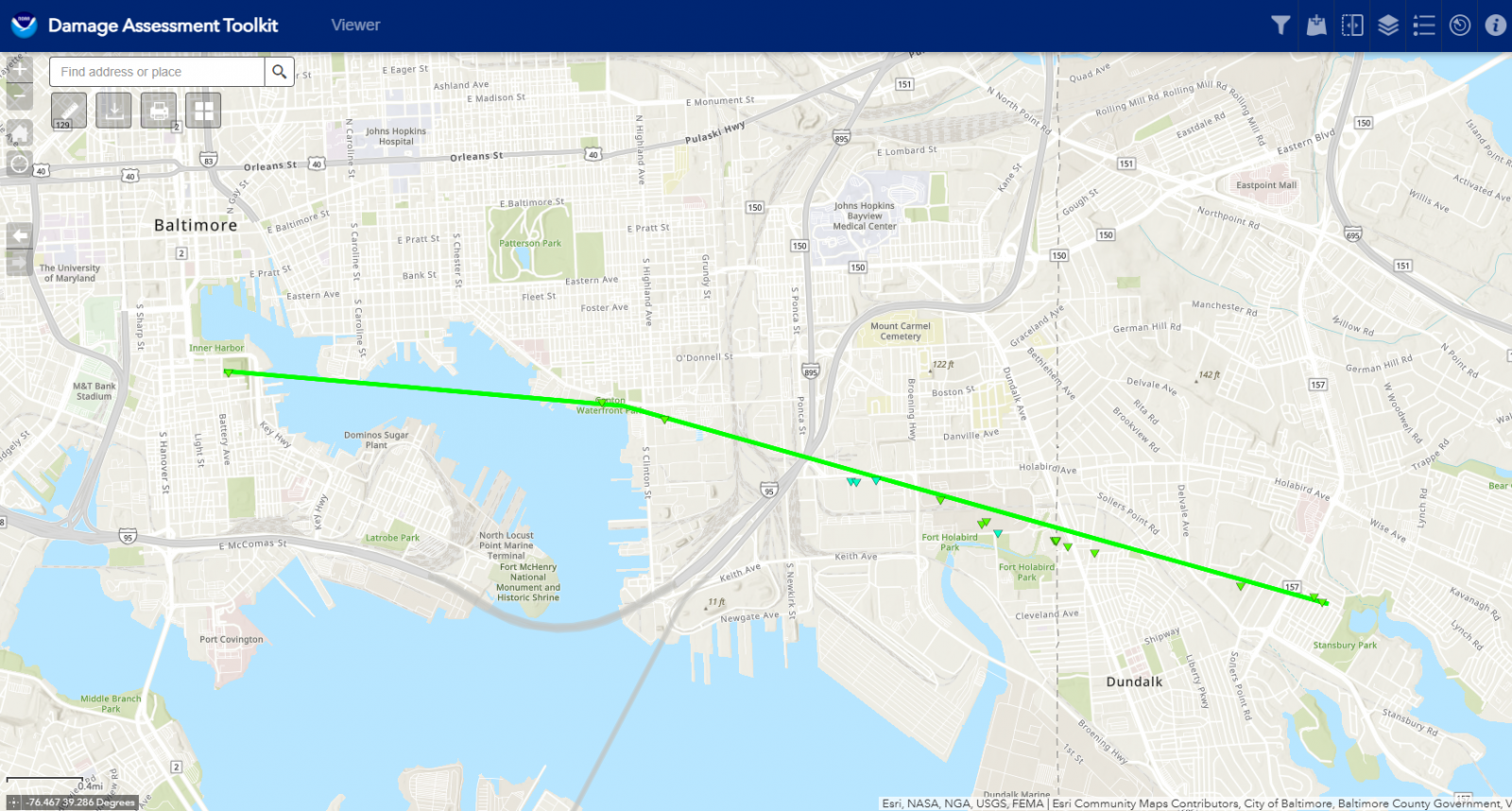
Link to NWS GIS Damage Assessment Toolkit viewer with surveyed damage points and pictures.
Link to all storm damage reported May 16th, 2025.
Public Information Statement
National Weather Service Baltimore MD/Washington DC
1246 PM EDT Mon May 19 2025

..NWS Damage Survey for 05/16/25 Tornado Event...

On the afternoon of Friday, May 16, 2025, a line of severe
thunderstorms fueled by unseasonably warm and humid air, moved
from eastern West Virginia to the Atlantic. A boundary from early
morning storms provided extra wind shear across northeastern
Maryland, which helped allow a tornado to form in Baltimore.

.Baltimore City MD to Dundalk MD Tornado...

Rating:                 EF-1
Estimated Peak Wind:    110 mph
Path Length /statute/:  5.8 miles
Path Width /maximum/:   75 yards
Fatalities:             0
Injuries:               0

Start Date:             May 16 2025
Start Time:             5:51 PM EDT
Start Location:         Baltimore, MD
Start Lat/Lon:          39.2796 / -76.6096

End Date:               May 16 2025
End Time:               6:01 PM EDT
End Location:           Dundalk, MD
End Lat/Lon:            39.2624 / -76.5043

National Weather Service Baltimore/Washington Weather Forecast
Office staff conducted a ground survey of storm damage that occurred
in the City of Baltimore and southeastern Baltimore County on the
evening of Friday, May 16, 2025.

During the mid-afternoon, a line of severe thunderstorms developed
across eastern West Virginia and Western Maryland and quickly moved
east into the early evening hours. Radar showed a significant
increase in organization of this line of storms as it moved from
Frederick and western Montgomery counties into Carroll and Howard
Counties in Maryland.

The first area of concentrated damage was located in Federal Hill
Park in the City of Baltimore, where on that hill there were a few
uprooted trees and snapped large branches in a linear path heading
east towards the Patapsco River. This is where the tornado touched
down at 5:51 PM EDT according to weather radar, and then moved
across the river south of Fells Point towards the Canton area. A
path of uprooted trees and snapped branches was then noted in Canton
Waterfront Park, from the shoreline through the park.

After this, the tornado moved east towards The Shops at Canton
Crossing. This is where the tornado punched a hole near the roofline
of the west facing wall of a fitness facility. Once wind entered the
building, it lifted off part of the east roof and blew it to the
east-southeast. Areas east of the shopping mall consist of rail
yards and industrial facilities, where no damage was noted by survey
or reported.

From Canton Crossing, the storm turned slightly right to the east-
southeast, towards Dundalk. The FAA’s Terminal Doppler Weather Radar
at Thurgood Marshall Baltimore/Washington International Airport
noted the strongest circulation being from this location onward
through the end of the life cycle of the tornado. The tornado moved
across Interstates 95 and 895 and then through the Holabird
Industrial Park, where it did some significant damage to several
warehouses. There was also one eyewitness report of seeing the swirl
of the tornado while at work during this time. Much of the warehouse
damage was due to the wind gaining access into the structures
through large garage or bay doors, which then caused uplift and
removal of large sections of roofing as well as some damage to
walls. One warehouse had a large portion of its structural metal and
wood awning damaged. While much of the damage was blown from west to
east, convergent tree damage was noted, and at an Amazon warehouse
on Holabird Avenue some damage was blown to the north. Two 18-wheel
tractor-trailer trucks were blown over at the Amazon facility.

The tornado then moved through northern portions of the Dundalk
Historic District, causing significant roof and siding damage to
several homes and apartments. One of the more significant damage
points in this area was a large portion of roofing that was removed
from a row of apartments and thrown towards the east-southeast into
the next row of apartments.

The tornado then continued towards the east-southeast towards
Merritt Blvd. The neighborhood just west of Merritt Blvd. received
extensive damage, both structurally and to trees. Many of the trees
had their middle and upper branches snapped off. The most
significant damage in this neighborhood was to a home’s roof that
was lofted from the west side of Sunberry Rd. onto Merritt Blvd. The
homeowner noted that he witnessed debris being carried through the
air right before his roof was removed. Beyond this point, the
tornado continued briefly towards the east-southeast towards
Stansbury Park. There was some damage in the neighborhood east of
Merritt Blvd. that remained consistent with a tornado, particularly
a wooden utility pole that had been bent over, but not snapped.
Damage beyond this point became uni-directional, providing evidence
that the tornado likely lifted around Stansbury Park at 6:01 PM EDT,
as the rear-flank downdraft winds undercut the circulation leading
to straight-line wind damage towards the east.

The National Weather Service Baltimore/Washington Weather Forecast
Office thanks the Baltimore County Office of Homeland Security and
Emergency Management, and the Baltimore City Office of Emergency
Management for their assistance in conducting and providing
information for this storm survey.


EF Scale: The Enhanced Fujita Scale classifies tornadoes into the
following categories:

EF0.........65 to 85 mph
EF1.........86 to 110 mph
EF2.........111 to 135 mph
EF3.........136 to 165 mph
EF4.........166 to 200 mph
EF5.........>200 mph


 Coastal Flood
 FAQ
FAQ