
Scattered severe storms capable of large to very large hail, severe wind gusts, and a few tornadoes will be possible across the central Plains this evening. Heavy to excessive rainfall may bring a flooding threat from the Great Lakes to the Mid-South through tonight. Hot, dry and windy conditions will continue to bring a critical fire weather threat from the Southwest into the Great Basin. Read More >
...Severe Line of Thunderstorms Blasts Region...
Tuesday July 8, 2014
Summary
During the late afternoon and evening of Tuesday July 8th, 2014, a severe line of thunderstorms moved rapidly east across the area, producing severe wind gusts and numerous downed trees. The most widespread damage (see blue shaded area on map below) extended thru eastern WV, western and northern MD, and extreme northern & northwestern VA. Trees were downed over roads, on homes, and into power lines. Large falling tree branches also resulted in the sad story from a camp in northeast Carroll County MD where there was one fatality and eight injuries in a group of kids that were trying to seek shelter from the rapidly approaching storm.
The storms were racing east at approximately 50 mph. Reported wind gusts ranged from 45 to 61 mph across the hardest hit area in our forecast area.
Map of Severe Reports
The map below shows severe reports received by NWS from Tuesday July 9th, 2014. Blue W's are wind damage, red T's are preliminary tornado reports (PA & OH), green H's are large hail reports, and the red dot is the site of the camp that had the 1 fatality and 7 injuries from falling tree branches. The shaded lighter blue area is roughly the area of most widespread damage from the line of thunderstorms.

Damage Report List
Here is a link to the list of all reported damage from the NWS Sterling forecast area as of Noon July 9th:
Danger Brewing (Outlook -> Watch -> Warning)
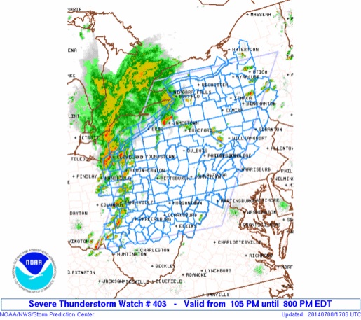
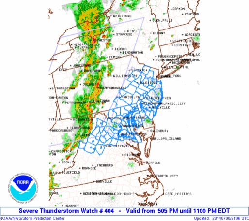
NWS meteorologists were monitoring the developing dangerous weather conditions over the weekend, and by early Sunday morning began to include that threat in the Hazardous Weather Outlook with thunderstorms that may "be capable of producing damaging wind gusts". That threat continued in the outlook into the early week. As NWS meteorologists became even more confident early in the afternoon on Tuesday, a Severe Thunderstorm Watch was first issued for western MD and eastern WV. That was followed by another Severe Thunderstorm Watch for an area southeast of the initial one, including northern & northwestern VA, most of the rest of MD, and Washington D.C. Severe Thunderstorm Watches are issued by the NWS for the potential of damaging winds and/or large hail over a broad region.
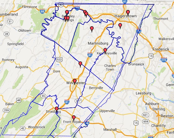
As the squall line moved rapidly across the region, Severe Thunderstorm Warnings were issued. Severe Thunderstorm Warnings are issued for targeted threat areas where damaging winds or large hail is expected. One of those warnings is mapped below. This is the Severe Thunderstorm Warning that was issued for the I-81 corridor from Hagerstown MD, down thru Martinsburg and Winchester, to Woodstock VA (the area outlined in blue). This was issued at 5:30pm and was in effect for 45 minutes until 6:15pm. The wind hit Martinsburg airport at 5:52pm and Winchester airport around 5:55pm, and Hagerstown at 6:01pm.
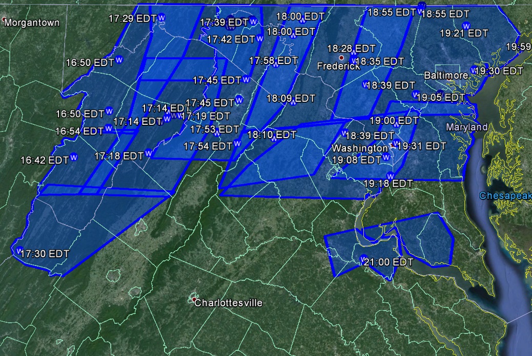
Between about 4:30 and 9:00pm on Tuesday, 12 Severe Thunderstorm Warnings were issued by the NWS Baltimore/Washington Forecast Office for our forecast area. They are mapped out below in blue. The areas of lighter blue shading are just areas where the warnings overlapped.
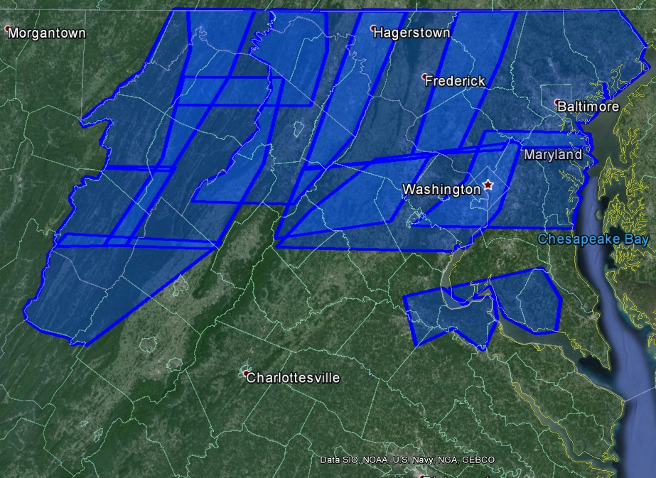
The last map shows the reported wind damage points (blue) overlaid on the warnings, with the estimated time it occurred (in 24hr/military time; i.e. 17:58 is 5:58pm).
In Conclusion
Always remember the NWS uses the watch/warning program to alert you to ANY weather threat! The watch/warning system is much like a traffic light. Green is OK. If there is a possible threat, the NWS will issue a watch saying there is the potential for that threat to happen, so KEEP A WATCH OUT (a yellow light, caution)! Stay connected and be ready to act if a warning is issued. If we move up to a WARNING (a red light), that means that threat is expected, so TAKE ACTION!
In this case, a Severe Thunderstorm Watch means we have the potential for severe thunderstorms, so be ready and KEEP A WATCH OUT! A Severe Thunderstorm Warning means we expect a severe, damaging thunderstorm to occur in a targeted area, within a short period of time (generally 10-60 minutes)...so TAKE ACTION AND SEEK SHELTER!
For future events, if you would like to better receive warnings from the National Weather Service, you can do any or all of the following:
* Purchase an inexpensive NOAA Weather Radio. These are particularly useful on the water, or other more remote areas where it is harder to get warnings through other means. https://www.weather.gov/nwr
* If available, sign up for county text alerts from your county. Just internet search out your county's webpage, or your county's emergency management webpage for information.
* Many private weather companies offer public text/PDA alerting as well.
* Check the Hazardous Weather Outlook each day. That will alert you to any potential weather threats being tracked for the next 7 days.
* As always, keep tabs on your weather forecast at weather.gov/washington. Click anywhere on that map for a forecast specific for the point you click.


 Coastal Flood
 FAQ
FAQ