|
| Yearly Reports |
| Interested in what kind of weather occurred in a recent year? Check out the most memorable events below. |
|
|
 |
Arkansas Yearly Climate Summary (2018)/Pg3 |
 |
| |
| Significant Events Across the Country |
|
|
| In the picture: Heavy to excessive rain prompted a Flash Flood Warning northwest of Los Angeles, CA on 01/09/2018. The warning included an area where a huge wildfire occurred in December, 2017. |
|
| |
|
Across the U.S., 2018 started with devastation in southern California. After a huge fire (at least 270,000 acres) raged to the northwest of Los Angeles, CA in early December, 2017, heavy rain hit on January 8th/9th. Where fire destroyed vegetation, slopes were vulnerable to mudslides. Three to more than five inches of rain in twenty four hours produced rivers of mud and rocks. Dozens of homes were destroyed. At least 18 people were killed.
|
|
|
| In the video: The satellite showed the third of four nor'easters to affect the mid-Atlantic states into New England in March, 2018 (on the 13th). |
|
| |
|
In early March, dozens of wildfires torched 25,000 acres in Kansas, and shut down Interstate 70 temporarily (due to low visibility in smoke). Several farmsteads near Catharine, KS (not far from Hays, KS) were evacuated as flames closed in.
While fires in the central Plains made headlines, the big story of the month was a train of nor'easters (four of them) that battered areas from the mid-Atlantic states to New England. The systems caused several million power outages, cancelled thousands of flights, closed schools and numerous roads.
The first system (on the 1st through the 3rd) battered coastal Massachusetts with 90 mph gusts, and produced unusually high tides (and inland flooding). It was the third highest storm surge on record in Boston, MA. Parts of upstate New York (including the town of Jefferson, NY) got two feet of snow. Storm number two (on the 6th through the 8th) was a big snow machine. Two to three feet of snow piled up from northern New Jersey (where hundreds of cars were stranded) to western Connecticut, western Massachusetts, and the mountains of Vermont. Storm number three (on the 12th through the 14th) cranked out similar snow totals a little father to the east. This time, Rhode Island to eastern Massachusetts and New Hampshire got buried in feet of powder. Close to 15 inches was measured in Boston. MA. The final system (on the 20th through the 22nd) produced a swath of heavy snow (over a foot) from West Virginia to southern Pennsylvania to Long Island, NY. It was the heaviest snow (7.6 inches) in 60 years at Philadelphia, PA. Reagan National Airport in Washington, DC had about four inches, which was the most snow so late in the season since the mid 1960s.
The latter system was preceded by at least twenty tornadoes on the 19th in portions of Alabama, Tennessee, and Georgia. The most powerful of these (rated EF3) ripped through Jacksonville, AL. This was the strongest tornado of the year thus far across the country. A very large hailstone measuring 5.25 inches in diameter and a circumference of 13.75 inches was collected in Cullman, AL. This was deemed the largest hail in state history.
|
| Strongest Tornado of 2018 in Canada |
|
Interestingly, there were no tornadoes rated EF4 or stronger across the United States in 2018. However, there was an EF4 tornado in Alonsa, Manitoba in Canada on August 3rd.
|
|
|
| In the video: Up until 2018, there was at least one tornado in Oklahoma through April. |
|
| |
|
Through April, there was a tornado drought in Oklahoma. Not one tornado was spawned, which had never happened before. Prior to 2018, the latest first tornado to occur was April 26, 1962. There was a lack of tornadoes because thunderstorms were few. It was very dry, which led to huge fires torching large tracts of land in western sections of the state. The largest fire burned over 240,000 near Rhea, OK in mid-April.
|
|
|
| In the picture: Catastrophic flash flooding occurred at Ellicott City, MD on 05/27/2018. |
|
| |
|
For the second time in less than two years, there was way too much rain in Ellicott City, MD on May 27th. Almost an inch of rain was measured in 10 minutes, with almost three inches in an hour and six to seven inches in three hours. Hudson Branch, a local tributary, rose five feet in 24 minutes and went out of its banks. Water ran through streets in town, and was up to the top of the first floor of buildings. The water caused catastrophic damage to homes, businesses, and vehicles. Miraculously, only one person was killed.
|
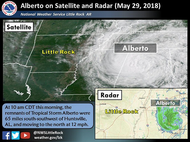 |
| In the picture: Subtropical Storm Alberto made landfall in the Florida panhandle on 05/28/2018 (Memorial Day). The system tracked into the Tennessee Valley, and stayed mostly to the east of Arkansas. Alberto was subtropical (versus tropical) because the storm developed with help of winds aloft and not just warm Gulf of America water. |
|
| |
|
The tropics came alive to finish May. The remnants of Subtropical Storm Alberto reached the Florida panhandle on the 28th. This was the first May tropical/subtropical system in the Gulf of America since 1976. There was way too much rain in western North Carolina (locally over six inches). This led to mudslides, and the collapse of a home in Boone, NC that killed two people.
|
|
|
| In the picture: A storm system aloft over southern Texas pushed tropical moisture toward Arkansas on 06/19/2018. |
|
| |
|
The tropics were at it again on May 19th/20th. A tropical system made it into south Texas from the Gulf of America, and wrung out over a foot of rain in a few hours. This was more than six months worth of liquid in a short while! In Weslaco, TX, more than 2000 homes were flooded, and hundreds of people were rescued.
|
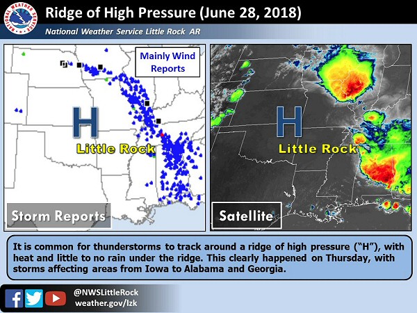 |
| In the picture: Most severe storms went around the eastern periphery of a ridge of high pressure ("H") on 06/28/2018. |
|
| |
|
In late June, at least two derechos (long lived clusters of wind producing thunderstorms) swept across areas from eastern Nebraska through the mid-Mississippi and Tennessee Valleys all the way to the central Gulf Coast. There were hundreds of reports of wind damage (gusts over 60 mph). The wind and a tremendous amount of lightning caused widespread power outages. In Alabama alone, over 200,000 households were without power.
|
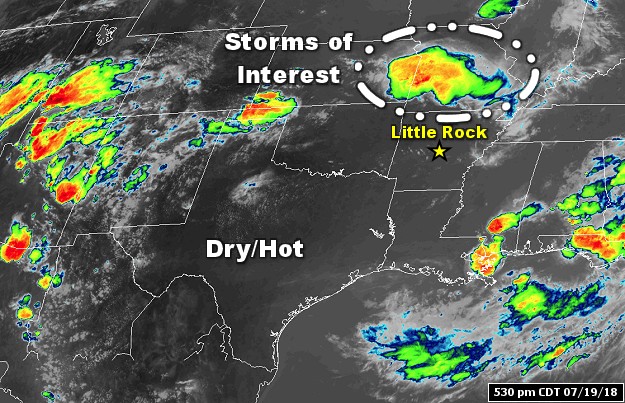 |
| In the picture: Dry/hot conditions and few clouds were noted from Arkansas to the southwest during the afternoon of 07/19/2018. This was due to high pressure building over the region. Clusters of thunderstorms were developing around the periphery of the high, with one cluster nearby in southwest Missouri. |
|
| |
|
On the 19th of July, a line of thunderstorms darted from southwest Missouri into northern Arkansas during the evening. The storms caused problems on Table Rock Lake near Branson, MO. The water got choppy, and caused a duck boat to sink. Tragically, seventeen people were killed in the accident. In Iowa, more than a dozen tornadoes were spawned. Damage was significant in Pella, Bondurant, and Marshalltown, where tornadoes were rated EF2/EF3.
|
|
|
| In the video: The Carr fire near Redding, CA raged out of control on 07/30/2018. The video is courtesy of CAL FIRE Shasta Trinity Unit & the Shasta County Fire Department. |
|
| |
|
By the end of July, two fires (Carr and Ferguson) in California had torched more than 150,000 acres, destroyed at least 1,000 structures, and killed eight people. These fires were outside of Redding, CA and near Yosemite National Park (300 miles apart).
In mid-August, rain was relentless in the northeast, and it very dry/hot across the west. Major flooding prompted a state of emergency in portions of Pennsylvania, upstate New York, and New Jersey. As this was happening, wildfires were consuming large tracts of land in at least ten western states.
|
|
|
| In the video: Hurricane Florence was just off the North Carolina Coast on 09/13/2018. The storm made landfall the next morning near Wrightsville Beach, NC. |
|
| |
|
Hurricane Florence made landfall near Wrightsville Beach, NC as a Category 1 storm (90 mph sustained wind) on September 14th. Once a Category 4 system, Florence wobbled inland and dumped two to three feet of rain in coastal North Carolina. Rivers were converted into lakes in the Carolinas, and hundreds of roads went under water. Thousands of evacuees wound up in shelters. More than 40 people were killed. When flood water began to recede, dead fish were strewn along miles of Interstate 40.
On the 20th/21st, there was a deluge in Oklahoma and Texas. More than 15 inches of rain was measured in Fittstown, OK and Stonewall, OK. High water made roads impassible at Ada, OK. These three towns are in Pontotoc County where a State of Emergency was declared. Farther south, Interstate 35 was closed for a time due to flooding around Denton, TX. On the 21st/22nd, 8.16 inches of precipitation fell at Dallas, TX. It proved to be too much, and people in and around town had to be rescued from their vehicles.
|
|
|
| In the video: A satellite loop shows Hurricane Michael winding up in the Gulf of America early on 10/10/2018. |
|
| |
|
In early October, Hurricane Michael strengthened as it approached the Florida panhandle. By the time Michael arrived near Mexico Beach, FL on the 10th, it was a strong Category 4 storm (sustained winds at 155 mph). In fact, it was the strongest hurricane to ever hit this part of the country, and the third most intense system to hit the United States (central pressure of 919 millibars). Michael was still a Category 3 storm by the time it reached Georgia, making it the most powerful hurricane in the state since 1898.
|
| Hurricane Michael Upgraded |
|
In April, 2019, Hurricane Michael was upgraded to a Category 5 storm (160 mph sustained winds). The last such storm to strike the United States was Hurricane Andrew on August 24, 1992.
|
|
Michael thrashed areas from Florida to Virginia with high winds, flooding (due to storm surge and heavy/excessive rain), and tornadoes. At least 30 people were killed and power was cut off to more than a million households. The system did not weaken below Tropical Storm status along the way.
It was very wet in Kansas City, MO through the 10th. The city got 10.05 inches of rain, with much of this occurring on the 6th through the 9th (9.79 inches). Only 0.71 inch fell the remainder of the month, making it the second wettest October (and not far from the record of 11.94 inches in 1941).
October ended with severe weather in eastern Texas, Louisiana, and Mississippi. At least two dozen tornadoes were spawned. Most of these were weak (rated EF0/EF1). In Mississippi, the tornadoes happened during the wee hours of November 1st while people were asleep. One person was killed when a car ran into a fallen tree (downed by a tornado) along Highway 61 a few miles north of Port Gibson, MS.
|
|
|
| In the picture: Red Flag Warnings were posted in southern California on 11/11/2018 given extremely critical conditions (dry vegetation and strong Santa Ana winds). |
|
| |
|
In November, conditions were perfect for wildfires in California. Not only was it dry, wind gusts reached 40 to 60 mph, and this fanned the flames.The largest of these fires (called the Camp Fire) was in northern sections of the state. As of November 15th, more than 500,000 acres were torched. At least 15,000 structures were burned to the ground, with the towns of Concow and Paradise destroyed. At least 80 people were killed, with 1,000 people missing. This was the deadliest and most destructive fire in state history.
In southern California, another big fire (the Woolsey Fire) wreaked havoc. At least 100,000 acres were burned, including 500 structures and dozens of homes in Malibu. At least 3 lives were lost.
|
|
|
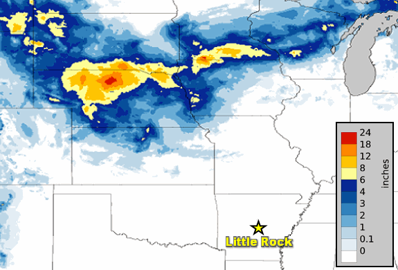
| In the picture: Forty eight hour snow accumulations through 600 am CST on 12/02/2018. |
|
| |
|
On December 1st, there was a huge contrast in conditions across the middle of the country. Heavy snow fell from Nebraska to southern Minnesota. Six inches to more than a foot of powder accumulated. In central Illinois, there were at least twenty nine tornadoes counted during the afternoon and evening. This was the state's largest December tornado outbreak on record, and third largest overall. The hardest hit town (described as a war zone) was Taylorville, IL, with over 500 buildings affected. At least twenty people were injured.
A week later, cold air was trapped on the east side of the Appalachians (a phenomenon called damming). A storm system tracking along the Gulf Coast was on its way, and was surrounded by abundant moisture. It was a perfect setup for tons of snow. In fact, two to three feet was snow was reported at a few locations in western North Carolina and western Virginia. On the 9th, 15 inches of snow piled up in Roanoke, VA. It was the heaviest calendar day snow in December locally. More than half a foot of snow accumulated in Raleigh, NC, which was the most December snow in at least 60 years.
|
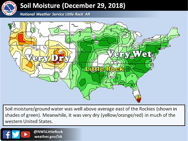 |
| In the picture: Soil moisture levels were well above average in many areas east of the Rockies on 12/29/2018. |
|
| |
|
2018 ended with soggy conditions across central and eastern sections of the country. It was the wettest year on record at multiple cities including Baltimore, MD, Charleston, WV, Lexington, KY, Washington, DC, and Wilmington, NC.
|
|
|