 |
| About This Page |
| Arkansas has had its share of historic events, many of which will be in our memories for years to come. |
|
|
 |
NOAA Weather Radio at the Albert Pike Recreation Area |
 |
| |
| |
| |
| There was a potential for flash flooding in Arkansas late on June 10th into the 11th. A storm system approaching from the southwest had a history of causing high water problems in Texas. A Flash Flood Watch was posted for much of the state as the system neared. The system tracked through the western counties during the wee hours of the 11th, and a cluster of thunderstorms produced excessive rain in portions of Polk, Pike and Montgomery Counties. A Flash Flood Warning was issued for this area. A follow-up Flash Flood Statement specifically targeted the Albert Pike Recreation Area. These products were broadcast on the Mount Ida (Montgomery County) and Mena (Polk County) NOAA Weather Radio All Hazards transmitters. |
| A History of the Mount Ida NOAA Weather Radio Transmitter |
| |
The Mount Ida NOAA Weather Radio All Hazards (NWR) transmitter was first put on the air in April, 2001. It was located just off U.S. Highway 270 near the Montgomery/Garland County line. The National Weather Service (NWS) does not own the towers on which NWR equipment is located; instead NWS locates a suitable tower owned by a private company and leases space on that tower. In the case of the Mount Ida NWR transmitter, the NWS leased space on a tower owned by a cell phone company.
On October 27, 2008, the cell phone company's cell phone tower collapsed. This occurred on a day when no weather was occurring. Other than the damage caused by the tower falling down, no other damage occurred on the mountain where the tower was located. The NWS does not know the reason the tower fell.
At the time, there was considerable uncertainty as to whether the cell phone company would put up a new tower at the same site. If the same company put up a new tower, the NWS could have moved the Mount Ida NWR equipment to the new tower without having to sign a new lease. The cell phone company finally chose not to rebuild their tower. Thus, the NWS had to find a new location for the NWR transmitter.
It was known that finding a new tower and executing a new lease would take time. Thus, as an interim measure, the NWS put up a temporary transmitting antenna at the original Mount Ida location on December 7, 2008. This antenna was much lower in elevation than the original antenna. Thus, the area covered by the transmitter was much less than what the Mount Ida transmitter originally had.
A number of towers in the general area of Mount Ida and Hot Springs were considered for a new transmitter site, but were ruled out as being unsuitable.
A new tower was eventually selected. It is near Norman in Montgomery County and is known as High Peak. NWR equipment was put on the tower (after a lease was obtained and signed), and the new transmitter was put on the air. |
| How is the Coverage of an NWR Transmitter Determined? |
| |
When a new NWR transmitter (such as High Peak) is broadcasting, someone from the contracting company or a National Weather Service employee will determine the effective range of that transmitter.
This process is done by driving around the area surrounding the transmitter with a receiver and monitoring equipment. They are looking for a certain signal strength - 5 microvolts, which is considered the strength sufficient to reliably set off the alarm on a person's NWR receiver. A map is drawn of the area where a 5 microvolt signal can be received. Then, when someone in a particular town inquires as to whether NWR can be received at his/her location, this map can be referred to.
Coverage of a particular transmitter often covers part of a county but not the whole county. The signal strength at a given location depends on a number of factors - type of transmitting antenna, how high above the ground the antenna is located, the terrain in the area, atmospheric conditions at a given time, and a number of other factors.
There may be times when the NWR voice can be heard in areas that do not have a signal as high as 5 microvolts. However, in such places, the NWS would say that NWR coverage is not available, since the signal would be too low to activate the NWR warning alarm on a person's receiver. |
| Was NWR Coverage Available at Albert Pike Recreation Area? |
| |
No, it had never been available at the recreation area.
Even when the Mount Ida transmitter was brand-new and operating at full power, the signal at the campground was well below 5 microvolts. |
|
|
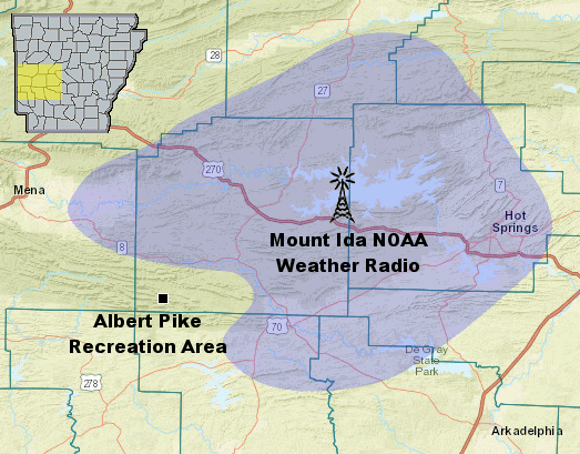
| In the picture: The extent of the 5 microvolt signal of the Mount Ida (Montgomery County) transmitter when it was at full strength (in blue). |
|
| |
The 5 microvolt coverage extended approximately as far south as Norman and Caddo Gap in Montgomery County.
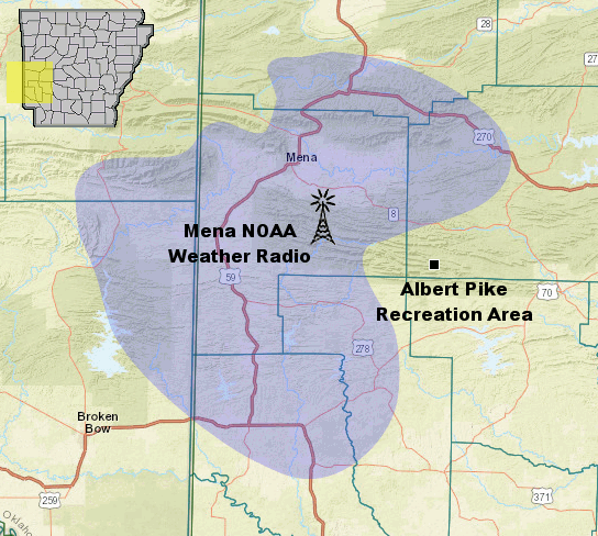
The Mena NWR transmitter covers only the northwestern part of Montgomery County. Thus, the Mena transmitter never covered the recreation area, either. |
|
|
| In the picture: The extent of the 5 microvolt signal of the Mena (Polk County) transmitter (in blue). |
|
| Does the New Transmitter Cover Albert Pike Recreation Area? |
| |
| Very steep hillsides around the campground make it very difficult for any radio or cell phone signals to reach into the valley in which the campground is located. Even so, the aforementioned High Peak boradcast does reach the campground, and the signal is at least 5 microvolts (the minimum threshold to receive warning information reliably). |
|
|
|