National Weather Service United States Department of Commerce
Monthly Storm Reports and Storm Data
Storm Reports
Are you interested in what happened during a recent event? Check out the report below.
 
April, 2025 Monthly Summary
 
Monthly Statistics
 
  Temperatures Precipitation
Site Max Min Avg Norm Dep Hi Lo Sum Norm Dep
Fayetteville (NW AR) 73.0 50.2 61.6 57.1 +4.5 87 31 14.29 5.01 +9.28
Harrison (NC AR) 71.7 49.8 60.7 58.3 +2.4 88 30 9.20 4.98 +4.22
Jonesboro (NE AR) 74.5 54.7 64.6 60.7 +3.9 86 37 13.73 5.15 +8.58
Fort Smith (WC AR) 76.8 54.6 65.7 62.1 +3.6 89 38 8.69 4.87 +3.82
Little Rock (C AR) 77.1 55.8 66.5 61.5 +5.0 88 42 13.96 5.59 +8.37
Texarkana (SW AR) 81.5 58.7 70.1 63.6 +6.5 89 44 11.99 4.43 +7.56
El Dorado (SC AR) 80.9 55.5 68.2 63.9 +4.3 90 38 8.56 5.39 +3.17
Pine Bluff (SE AR) 79.8 57.1 68.5 63.1 +5.4 89 41 10.89 5.35 +5.54


Monthly temperatures and rainfall totals were well above normal. 


Record Temperatures
 
High temperature records broken in April. Check out the records below.


Site Record High (Date of Occurrence)
Batesville 85 (4/13), 86T (4/28)
Hot Springs 86T (4/13)
Jacksonville/LRAFB 88T (4/13), 88T (4/28)
Monticello 86T (4/26), 88T (4/27)
Mount Ida 88 (4/25)
Stuttgart 86T (4/13), 85 (4/20), 89 (4/28)


In April 2025, Arkansas experienced a tumultuous weather pattern marked by severe storms, record-breaking rainfall, and deadly flooding.

Early April: Catastrophic Storms and Flooding


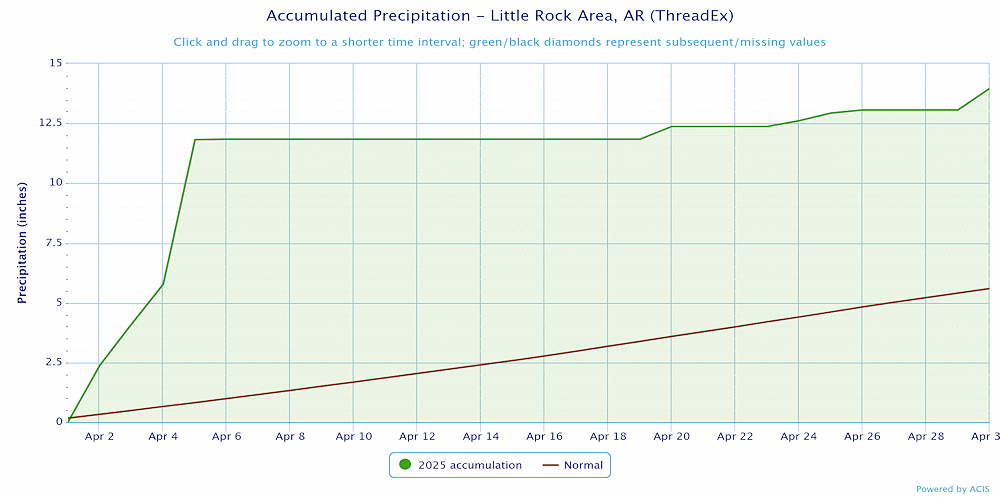
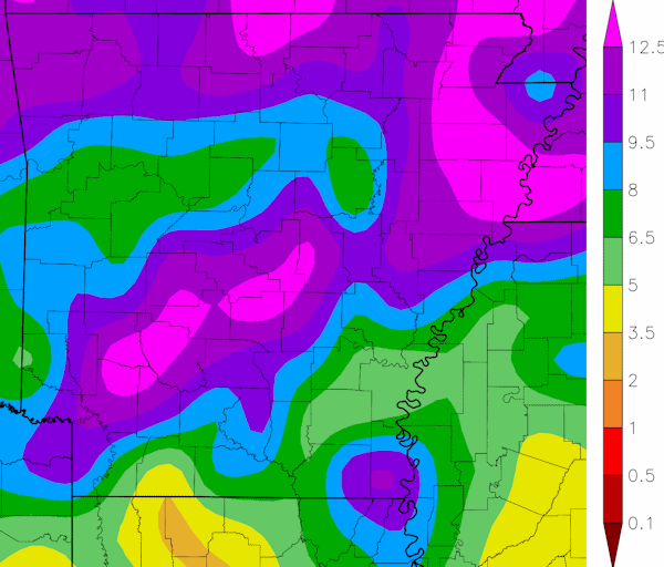
The month began with a series of intense storm systems sweeping through the Mid-South, including Arkansas. These storms brought unprecedented rainfall, leading to historic flash flooding across the region. The amount and intensity of the rainfall was compared to events that only happen once in a generation to once in a lifetime. Rainfall totals from April 2-5 were as much as 14.14", with localized amounts of 5-8 inches within 24 hours. The deluge prompted widespread flood watches and warnings, and led to major flooding across numeorus rivers in Arkansas. 

The severe weather from April 2-5 resulted in 3 fatalities in Arkansas along with 14 injuries, primarily due to flooding, and caused significant economic/agricultural damages. 16 tornadoes occurred during this timeframe. Severe thunderstorms on April 5th produced a powerful microburst in Miller County that had winds of up to 100 mph. Later on April 5th a line of severe thunderstorms produced widespread damage across central Arkansas with wind gusts up to 80 mph. Large hail also occurred, with the largest hail being 3 inches in diameter in Cleveland County on April 3rd.

 
Link of Interest
April 2-5, 2025 Storm Reports
 

Mid to Late April: Continued Severe Weather

The threat of destructive storms persisted throughout the month. Supercell thunderstorms brought large hail, tornadoes, and up to 7 inches of rain, exacerbating the risk of flooding in already saturated areas. Numerous rivers in the region reached flood stage once again or had ongoing flooding worsen. On April 30th a line of severe storms moved across Little River County and produced damaging winds up to 90 mph near Foreman.

 
Temperatures at Little Rock (Pulaski County).
In the picture: Temperatures at Little Rock (Pulaski County). Click to enlarge.


Precipitation at Little Rock (Pulaski County).
In the picture: Precipitation at Little Rock (Pulaski County). Click to enlarge.


Precipitation across Arkansas.
In the picture: Precipitation across Arkansas.


Link of Interest
Detailed Monthly Statistics