Arkansas has had its share of historic events, many of which will be in our memories for years to come.
Historic Flooding in 2019 (Arkansas River/Tropical Storm Barry)
In the picture: The 500 millibar (18,000 feet) map showed a ridge of high pressure ("H") building over the southeast United States at 100 am CDT on 05/23/2019. Storm systems ("L") were forced to go around the periphery of the high and away from Arkansas.
In late May, there was a big ridge of high pressure over the southeast United States. The high brought Arkansas several days of very warm and dry weather. Storms systems and active weather were forced to go around the high and away from the region.
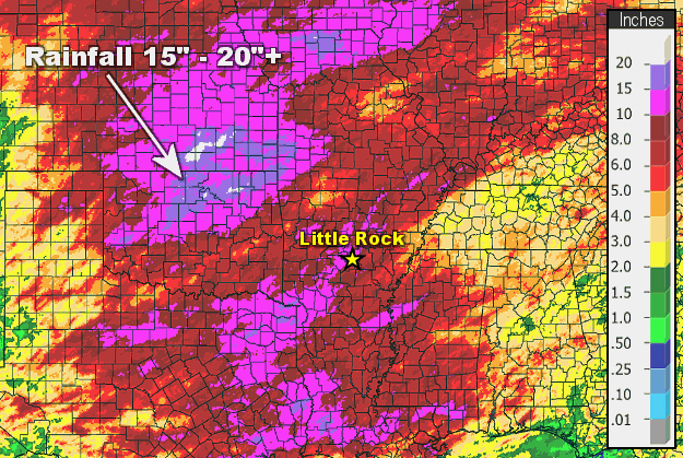
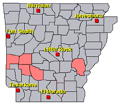
In the picture: Rainfall in May, 2019.
While there was above to well above average precipitation locally before the ridge strengthened, downpours were even more intense in southeast Kansas and northeast Oklahoma. Fifteen to more than twenty inches of precipitation fell in this part of the country.
In the picture: Following heavy rain in Oklahoma, the water level on Keystone Lake was well above normal (more than twenty five feet too high) and was dangerously close to the flood pool on 05/22/2019. The graphic (edited) is courtesy of the U.S. Army Corps of Engineers, Tulsa District.
Lake levels became dangerously high, and water releases were necessary. Near Tulsa, OK, releases (greater than 250,000 cubic feet per second) at Keystone Dam were more than double the flow of Niagara Falls. The Arkansas River was about to go haywire.
The Arkansas River at Muskogee has reached its second highest level in recorded history this evening, surpassing the 1986 flood. #okwx#OKfloodpic.twitter.com/mCHfKpHVCE
In the picture: The Arkansas River at Muskogee, OK reached its second highest level in recorded history during the evening of 05/22/2019.
On the 22nd, the river wreaked havoc in Webbers Falls, OK. Residents were urged to evacuate as water inundated large tracts of land and engulfed homes. During the evening, the river reached its second highest level on record at Muskogee, OK. It was a similar situation just west of Fort Smith (Sebastian County) on the 26th, with water everywhere in Moffett, OK.
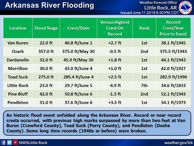
In the picture: Record or near record crests occurred along the Arkansas River in late May and early June, 2019. At several forecast points, previous record crests were surpassed by more than two feet.
In late May/early June, the river rose to unprecedented levels in Arkansas. Crests were more than two feet above previous high marks at Van Buren (Crawford County), Toad Suck (Perry County), and Pendleton (Desha County).
In the video: Water from the Arkansas River was flooding homes near Two Rivers Park about eight miles northwest of Little Rock (Pulaski County) on 05/29/2019. The video is courtesy of the Arkansas State Police.
Evacuations became necessary as homes and businesses flooded. Levees were breached, including one near Dardanelle (Yell County). The water was headed toward town, with 300 to 400 homes in danger of going under water.
In Dardanelle today getting updates from city and county officials along with Governor @AsaHutchinson. We are working hard to make sure this situation stays under control. #arwxpic.twitter.com/KzBTPDIlQ1
— Mayor Richard Harris (@MayorHarrisRSVL) June 2, 2019
In the pictures: City, county, and state government officials got together on 06/02/2019 to work on a solution to a levee breach near Dardanelle (Yell County). The information is courtesy of Mayor Richard Harris of Russellville (Pope County) via Twitter.
Sandbagging took place to protect property from rising water. While many homes were spared, farms and farmland in the area were heavily impacted, and there was major damage to Highway 155. There was a potential for more homes to be impacted by overtopped levees from Little Rock (Pulaski County) to Pine Bluff (Jefferson County).
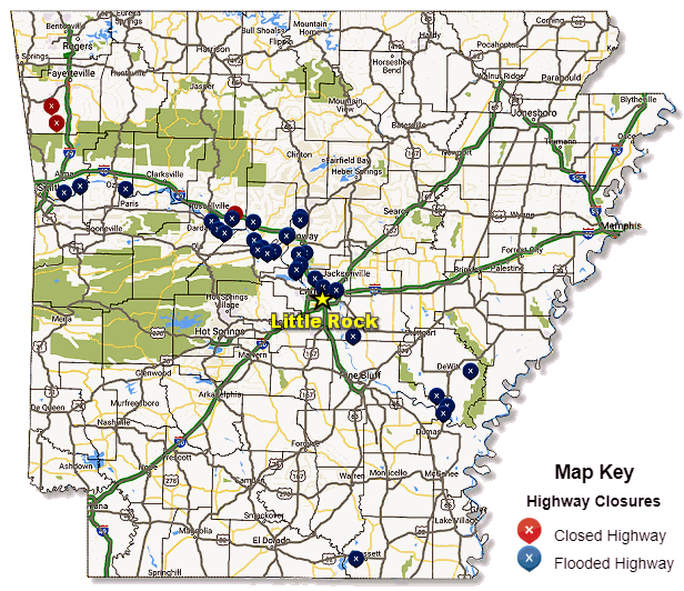
In the picture: The path of the Arkansas River was clearly marked by flooded highways from west central through central and southeast Arkansas on 06/07/2019. The graphic is courtesy of IDriveArkansas.
Numerous highways were closed and flooded. This included Highway 22 near Barling (Sebastian County), which did not open until water receded on the 4th (after cresting on the 1st). A 64-year-old man lost his life on this highway on May 28th after driving around a barricade.
An important message for residents of Faulkner County along Lake Conway...
In the picture: A Flood Warning was issued for Lake Conway (Faulkner County) on 06/03/2019 as Palarm Creek backed up due to a record high Arkansas River.
There was also a lot happening around Conway (Faulkner County). On the 3rd, a Flood Warning was issued for Lake Conway as Palarm Creek backed up. People were advised to evacuate before water flowed into houses surrounding the lake a couple of days later.
— City of Conway, Arkansas (@CityofConway) June 7, 2019
In the picture: The Lollie Levee near Conway (Faulkner County) held its ground on 06/07/2019 against a record high Arkansas River. The information is courtesy of the City of Conway via Twitter.
Meanwhile, there were images of Lollie Levee eroding, and it appeared that failure was imminent. This put parts of Conway (Faulkner County) in danger of flooding. There were more evacuations, and the situation was monitored closely. By the 7th, it became clear that the levee would hold. The levee was presented a key to the city on the 10th.
Just after 600 pm CDT, the satellite showed Tropical Storm Barry churning just off the Louisiana Coast, with a large area of thunderstorms south of the center of circulation. In Arkansas, there were isolated showers in southeast sections of the state.#arwxpic.twitter.com/eHXLKjQjgV
In the video: The satellite showed Tropical Storm Barry hugging the Louisiana Coast during the early evening of 07/12/2019.
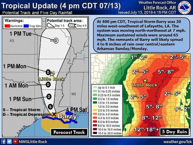
In July, minimal Hurricane Barry (75 mph sustained winds) hit the Louisiana Coast on the 13th. This was bad news for a lot of farmers in Arkansas that were trying to get crops going after a very wet spring and overflowing rivers. The remnants of Barry promised to bring another deluge to the region, and threatened to flood fields and wipe out underdeveloped plants.
In the picture: Tropical Storm Barry (downgraded from a minimal hurricane) was in southwest Louisiana during the afternoon of 07/13/2019. The system was expected to track through western Arkansas, and produce heavy to excessive rain in the days to follow.
The forecast called for the system to head through western sections of the state, with heavy rain east of the track. More than half a foot of precipitation was expected across the central and eastern counties.
At 230 pm CDT...the radar showed lots of rain and embedded thunderstorms from the eastern half of Arkansas into western Tennessee, much of Mississippi, and Louisiana. This was east of the track of Tropical Storm Barry in northwest Louisiana.#arwxpic.twitter.com/NM0IQInz0n
In the video: The WSR-88D (Doppler Weather Radar) showed widespread rain over the eastern half of Arkansas on 07/14/2018.
While it certainly rained, it did not come down in buckets. Rain was generally light to moderate, and spread out over a couple of days. Overall, it did not measure up to the hype, with many areas receiving two to five inch amounts.
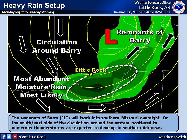
In the picture: As the remnants of Barry tracked into southern Missouri, forecast models showed lots of moisture and heavy rain on the south/east side of the system during the early morning hours of 07/16/2019.
While it appeared we dodged a bullet, Barry had one last card to play. As the system exited into southern Missouri, there were signs that the sky would open in parts of southern Arkansas during the wee hours of the 16th. In fact, some data indicated more than ten inches of rain in a small portion of the southwest. Given an underwhelming event thus far, it seemed this much rain was a little far fetched. But because data did not back down, and kept showing impressive totals, it was difficult to ignore. Forecasters chose to stick with the data and put out the word that Barry was not done.
In the video: The WSR-88D (Doppler Weather Radar) showed thunderstorms with torrential downpours developing over the same areas (mainly southwest Arkansas) from 500 am to 900 am CDT on 07/16/2019.
In the end, the data was correct. The radar lit up in the southwest late on the 15th, and continued well into the next morning. Rainfall rates exceeded three inches per hour at times.
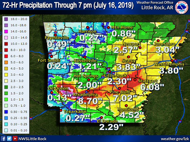
In the picture: Seventy two hour rainfall through 700 pm CDT on 07/16/2019.
Six inches to more than a foot of liquid was estimated by radar in sections of Clark, Hempstead, Howard, Nevada, and Pike Counties. Flash Flood Emergencies were issued by the National Weather Service in these areas.
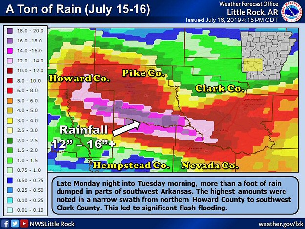
In the picture: Twenty four hour rainfall through 700 pm CDT on 07/16/2019. Parts of southwest Arkansas received more than a foot of precipitation.
Near Murfreesboro (Pike County), 13.50 inches of rain was reported. Since the 14th, the site had 14.58 inches, which was temporarily a state record for precipitation tied to a tropical system (since 1950).
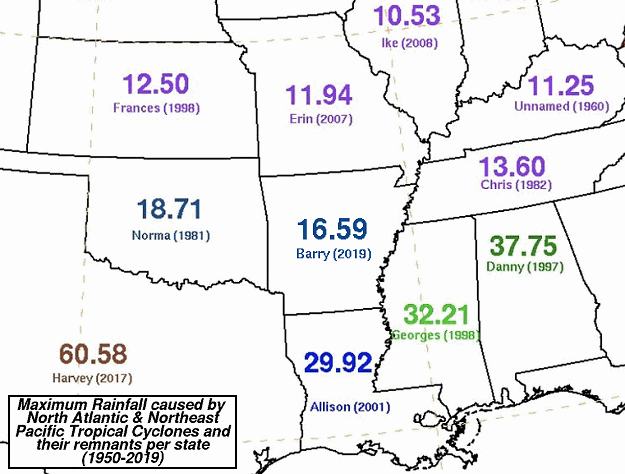
In the picture: Maximum rainfall caused by tropical cyclones in Arkansas and surrounding states from 1950 to 2019. The graphic is courtesy of the Weather Prediction Center (WPC).
Then there was word of an astounding 16.59 inches at Dierks (Howard County) in three days, which became the new tropical high mark. Of this, 16.17 inches dumped from 100 pm CDT on the 15th to 100 pm CDT on the 16th. Up until this point, the most rain that fell in a day across Arkansas was 14.06 inches near Big Fork (Polk County) on December 3, 1982. With so much rain in such a short amount of time, a nightmare high water scenario unfolded.
In the video: There was water everywhere in Gurdon (Clark County) following excessive rain early on 07/16/2019. The video is courtesy of Brian Emfinger via Twitter.
Water flooded roads, homes, and businesses in a narrow swath from just east of De Queen (Sevier County) to Dierks and Nashville (Howard County), Murfreesboro (Pike County), Prescott (Nevada County), and Arkadelphia (Clark County). Dozens of rescues were performed (from flooded homes, trees, and vehicles driven into water). Miraculously, there were no fatalities.
At Arkadelphia (Clark County), water was knee deep at one point at the humane society, and animals swam for their lives. Residents were asked to take animals home until the facility could get back on its feet. South of town, Interstate 30 was shut down near Gurdon (Clark County) and toward Prescott (Nevada County). Between these cities, traffic was backed up for ten miles at one point. There was considerable water damage at the police department and county jail in Nashville (Howard County). At the latter location, inmates had to be relocated.
Major thoroughfares in the southwest were still experiencing flood issues on the 17th. Several highways remained closed until water eventually receded.
Storm Reports
There were a several reports of heavy rain and flash flooding in southwest Arkansas on July 16th. For a look at the reports, click here.