National Weather Service United States Department of Commerce
Monthly Storm Reports and Storm Data
Storm Reports
Are you interested in what happened during a recent event? Check out the report below.
 
March, 2025 Monthly Summary
 
Monthly Statistics
 
  Temperatures Precipitation
Site Max Min Avg Norm Dep Hi Lo Sum Norm Dep
Fayetteville (NW AR) 69.6 40.7 55.1 48.4 +6.7 83 25 1.66 3.98 -2.32
Harrison (NC AR) 68.6 42.6 55.6 49.2 +6.4 84 27 1.63 3.91 -2.28
Jonesboro (NE AR) 68.6 45.2 56.9 51.1 +5.8 85 31 2.65 4.73 -2.08
Fort Smith (WC AR) 73.5 45.2 59.4 53.5 +5.9 87 31 1.70 3.90 -2.20
Little Rock (C AR) 71.1 47.2 59.1 52.7 +6.4 85 32 2.32 4.96 -2.64
Texarkana (SW AR) 75.7 51.4 63.6 56.0 +7.6 91 35 3.32 4.45 -1.13
El Dorado (SC AR) 73.6 46.3 60.0 56.3 +3.7 90 28 3.12 5.10 -1.98
Pine Bluff (SE AR) 73.1 48.7 60.9 54.6 +6.3 86 32 1.75 5.29 -3.54


Monthly temperatures were well above normal and rainfall totals were well below normal. 


Record Temperatures
 
High temperature records broken in March. Check out the records below.


Site Record High (Date of Occurrence)
Batesville 82 (3/27), 82 (3/28), 84 (3/30)
Harrison 82 (3/27)
Hot Springs 83 (3/25), 87 (3/30) 
Jacksonville/LRAFB 86 (3/30)
Monticello 86 (3/25)
Mount Ida 88 (3/30)
North Little Rock 84 (3/30)
Stuttgart 81 (3/25), 84 (3/27), 86 (3/28)


Well above normal temperatures and dry conditions were seen at the start of the month but a strong storm system brought windy conditions and strong thunderstorms to the state on the 4th. Windy conditions persisted after the storms moved through with gusts above 40 mph continuing through the 5th. In the wake of the storm system, some light snow was observed across northern portions of the state with little to no accumulation seen.


Temperatures began to warm up and dry conditions were observed through the 7th before a new storm system brought mostly light rain and cooler temperatures for the 8th and 9th. Northern Arkansas saw little to no rainfall with amounts elsewhere generally less than one half to 1 inch. A warming trend began on the 10th which continued through the 14th. 

 
Link of Interest
March 14-15, 2025 (Severe Storms)
 

A major severe weather event took place late on the 14th into the 15th with some light snow/sleet occurring early on the 15th. Dusty conditions were observed as well, as strong winds transported dust from the SW US into Arkansas on the 14th and 15th. Strong winds persisted through the 16th.

A major fire weather day occurred on March 19th when afternoon RH values plummeted and winds gusted over 50 mph in numerous locations. Over 96 wildfires were reported with some homes being destroyed and road closures taking place as wildfires occurred. Red flag warnings, wind advisories and blowing dust warnings were in effect that day. Dust caused major issues along roadways in northeast Arkansas. 

A second active fire weather day occurred on the 21st with dry air and gusty winds occurring once again. A red flag warning was in effect, winds weren’t quite as strong, but several wildfires broke out. 

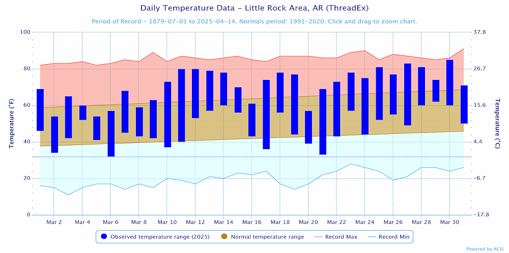
Dry conditions persisted through the end of the month along with near summer like temperatures. Record highs were tied or broken at several locations from March 25-30.

 
Temperatures at Little Rock (Pulaski County).
In the picture: Temperatures at Little Rock (Pulaski County). Click to enlarge.


Precipitation at Little Rock (Pulaski County).
In the picture: Precipitation at Little Rock (Pulaski County). Click to enlarge.


Precipitation across Arkansas.
In the picture: Precipitation across Arkansas.


Link of Interest
Detailed Monthly Statistics