 |
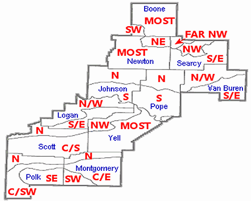
| In the picture: Eleven counties (white) in the Little Rock (LZK) County Warning Area were split into twenty five zones based on elevation (mainly in the Ozark and Ouachita Mountains in northern and western sections of the state). Three counties (gray) in the Tulsa (TSA) County Warning Area were also divided (in the Arkansas River Valley). In the map, abbreviations are as follows..."N" is north, "S" is south, "E" is east, "W" is west, "NW" is northwest, "NE" is northeast, "SW" is southwest, "SE" is southeast, "C" is central, and "MOST" is most of the county. |
|
|
On April 5, 2022, eleven counties in northern and western Arkansas (Ozark and Ouachita Mountains) were split into twenty five zones based on climatological differences (mainly due to terrain) and to help forecast elevation dependent weather events more accurately. The split affected Boone, Johnson, Logan, Montgomery, Newton, Polk, Pope, Scott, Searcy, Van Buren, and Yell Counties. Roughly four years later, three counties were divided in west central sections of the state (Arkansas River Valley). This included Crawford, Franklin, and Sebastian Counties.
|