 |
| For Your Information |
| If there is something that may be of interest to you, we will try to make that information available. |
|
|
 |
New Elevation Based Zones in the Little Rock County Warning Area |
 |
| |
| On October 1, 1993, National Weather Service (NWS) forecast zones in Arkansas were reconfigured from multiple counties per forecast zone to each of the 75 counties becoming its own forecast zone. While dividing forecast zones by county allowed for more detail and precision, it did not account for elevation. |
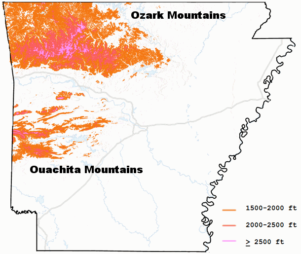 |
| In the picture: Elevations above 1500 feet in Arkansas are in the Ozark and Ouachita Mountains across northern and western sections of the state. |
|
| |
|
While much of the elevation of Arkansas is less than 1,000 feet above sea level, there are significant elevation differences in terrain over northwest/northern Arkansas (the Ozark Mountains) and western Arkansas (the Ouachita Mountains). These mountains, though minor in comparison to ranges such as the Appalachians and Rockies, do contribute significantly to the climate in terms of temperatures and precipitation.
|
|
|
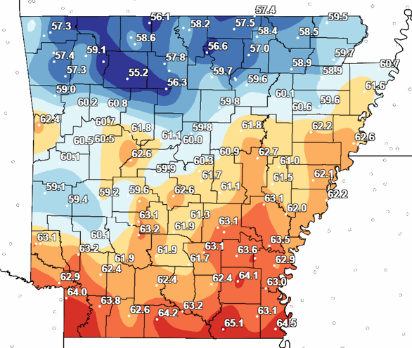
| In the picture: 1991-2020 Average annual temperature for Arkansas. |
|
| |
|
Average temperatures are generally cooler in the higher elevations of the north and west. Of more importance is how much readings vary across several counties in the north/west. In Johnson and Pope Counties, for example, temperature differences are as high as five degrees from north (higher terrain) to south (Arkansas River Valley).
|
|
|
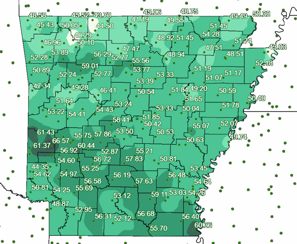
| In the picture: 1991-2020 Average annual precipitation for Arkansas. |
|
| |
|
As far as precipitation, the driest amounts are in the Ozark Mountains, and parts of the Ouachita Mountains (mainly Montgomery and Polk County) have the wettest totals. Precipitation differences across some counties in the north/west are vast, and differ by five to ten inches (especially in the Ozark Mountains).
|
|
|
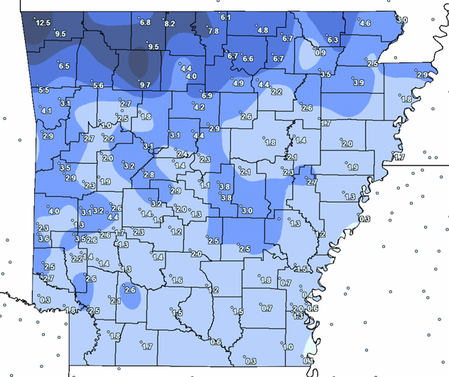
| In the picture: 1991-2020 Average annual snowfall for Arkansas. |
|
| |
|
The most snow typically occurs in the north/west. As was the case with average temperatures and precipitation, there is a wide range in snowfall across a few counties.
|
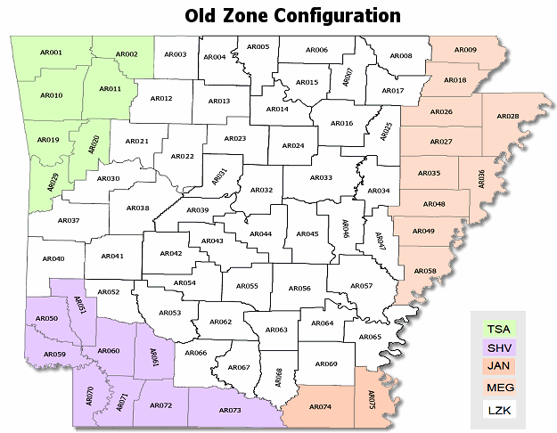 |
| In the picture: Old zone configuration in Arkansas. Five National Weather Service offices serve the state: Little Rock (LZK), Tulsa (TSA), Shreveport (SHV), Jackson (JAN), and Memphis (MEG). |
|
| |
|
Over the last few years, Arkansas has experienced several elevation-dependent winter precipitation events, with larger sleet, snow, and ice accumulations in the higher terrain versus the remaining area. These accumulations have been a difference of Winter Warning and/or Advisory criteria being met and not being met within the same county.
|
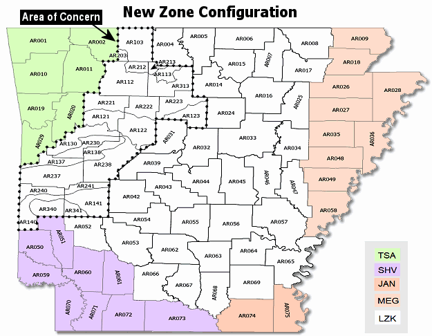 |
| In the picture: New zone configuration in Arkansas. Eleven zones in the Little Rock (LZK) County Warning Area were split into twenty five zones based on elevation (mainly in the Ozark and Ouachita Mountains in northern and western sections of the state). |
|
| |
|
To mitigate issues such as this, and to add more precision to text forecasts and long-fused watches, warnings and advisories, NWS Little Rock reconfigured eleven (11) forecast zones in the north and west.
|
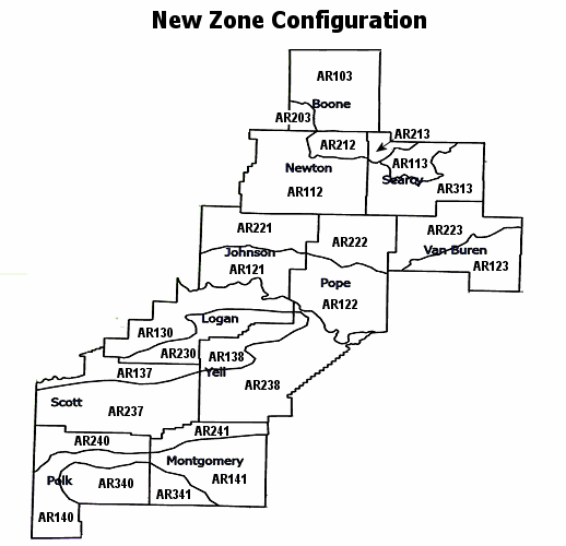 |
| In the picture: Closeup of new zone configuration in northern and western Arkansas. |
|
| |
|
This configuration allows forecasters at the office to better address incoming weather systems, and issue more accurate products to local partners and customers.
|
| More Specifics Concerning New Configuration |
| |
| The following products were affected by the NWS Little Rock public/fire zone changes effective April 5, 2022: |
| |
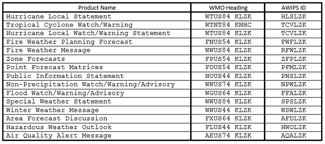 |
| In the table: Affected products by new zone configuration. |
|
| |
| The following forecast zones were affected by the NWS Little Rock public/fire zone changes effective April 5, 2022: |
| |
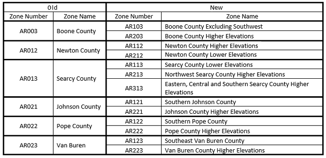 |
| In the table: Changes in the Ozark Mountains. |
|
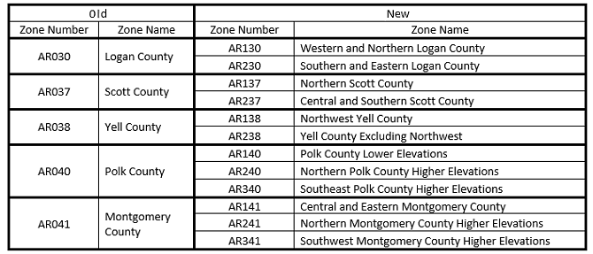 |
| In the table: Changes in the Ouachita Mountains. |
|
| |
New zone configuration headers...
ARZ103-DDHHMM-
Boone Excluding Southwest
Including the cities of Harrison and Lead Hill

ARZ203-DDHHMM-
Southwest Boone

ARZ112-DDHHMM-
Newton Higher Elevations
Including the cities of Boxley, Deer, and Ponca

ARZ212-DDHHMM-
Newton Lower Elevations
Including the cities of Jasper and Western Grove

ARZ113-DDHHMM-
Searcy Lower Elevations
Including the cities of Gilbert, Marshall, and Saint Joe

ARZ213-DDHHMM-
Northwest Searcy Higher Elevations
Including the city of Pindall

ARZ313-DDHHMM-
Eastern, Central and Southern Searcy Higher Elevations
Including the city of Leslie

ARZ121-DDHHMM-
Southern Johnson
Including the cities of Clarksville, Coal Hill, Hartman, and Knoxville

ARZ221-DDHHMM-
Johnson Higher Elevations
Including the cities of Oark and Ozone

ARZ122-DDHHMM-
Southern Pope
Including the cities of Atkins, Hector, London, and Russellville

ARZ222-DDHHMM-
Pope Higher Elevations
Including the cities of Nogo, Pelsor and Tilly

ARZ123-DDHHMM-
Southeast Van Buren
Including the cities of Clinton, Damascus, Fairfield Bay, Scotland, Shirley

ARZ223-DDHHMM-
Van Buren Higher Elevations
Including the cities of Botkinburg and Dennard

ARZ130-DDHHMM-
Western and Northern Logan
Including the cities of Booneville, Caulksville, Paris and Subiaco

ARZ230-DDHHMM-
Southern and eastern Logan
Including the cities of Blue Mountain, Mount Magazine, and Sugar Grove

ARZ137-DDHHMM-
Northern Scott
Including the cities of Mansfield and Waldron

ARZ237-DDHHMM-
Central and Southern Scott
Including the cities of Boles, Waldron, and Y City

ARZ138-DDHHMM-
Northwest Yell
Including the cities of Havana and Waveland

ARZ238-DDHHMM-
Yell Excluding Northwest
Including the cities of Danville, Dardanelle, Ola and Plainview

ARZ140-DDHHMM-
Polk Lower Elevations
Including the cities of Grannis, Hatfield, Mena, and Nunley

ARZ240-DDHHMM-
Northern Polk Higher Elevations
Including the cities of Acorn, Mountain Fork, and Rich Mountain

ARZ340-DDHHMM-
Southeast Polk Higher Elevations
Including the cities of Big Fork and Hartley

ARZ141-DDHHMM-
Central and Eastern Montgomery
Including the cities of Mount Ida, Norman, and Oden

ARZ241-DDHHMM-
Northern Montgomery Higher Elevations
Including the city of Story

ARZ341-DDHHMM-
Southwest Montgomery Higher Elevations
Including the city of Albert
|
|