|
| Storm Reports |
| Are you interested in what happened during a recent event? Check out the report below. |
|
|
 |
Active Weather Then Very Hot on August 7-13, 2023 |
 |
| |
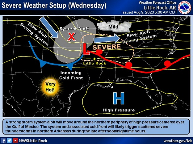 |
| In the picture: A strong storm system and associated cold front moved around the periphery (to the north) of hot high pressure centered over the Gulf of America on 08/09/2023. Scattered severe thunderstorms were triggered in northern Arkansas during the nighttime hours, as well as flooding rain in places. |
|
| |
|
August began with excessive heat/oppressive conditions and triple digit temperatures at Little Rock (Pulaski County) on three of the first five days. After that, the big ridge of high pressure responsible for the heat settled toward the Gulf of America. That opened the door to incoming storm systems and fronts, and summer thunderstorms with springtime fury. The good news is the heat took a break.
|
|
|
| In the picture: A somewhat rare (for August) tennis ball size hailstone was collected ten miles southwest of Leslie (Searcy County) early on 08/07/2023. The photo is courtesy of Misfit Electronic Repairs/Gaming via X (formally Twitter). |
|
| |
|
Early on the 7th (mostly before dawn), tennis ball size hail was noted near Chimes (Van Buren County) and about ten miles southwest of Leslie (Searcy County). Hail this size is rare in August. The last time it happened was on the 12th in 2012 a few miles northwest of Tontitown (Washington County). Golf ball size hail was reported close to Wolf Bayou (Cleburne County).
|
|
|
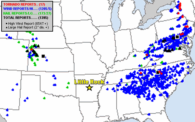
| In the picture: There were hundreds of severe weather reports (mainly damaging winds) from the Tennessee Valley and central Appalachians to the mid-Atlantic Coast and then north to the eastern Great Lakes on August 7-8, 2023. |
|
| |
|
Later in the day and on into the next morning, an outbreak of severe weather occurred from the southeast United States to the eastern Great Lakes. Hundreds of reports of wind damage along with isolated tornadoes were received. There were more reports counted during this event (in a twenty four hour period) than on other day in 2023. That's impressive given the time of year (not spring)!
|
|
|
| In the video: A strong pressure gradient between high pressure to the north of Hawaii and Hurricane Dora (very low pressure) to the south created damaging wind gusts on Maui on 08/08/2023. Near the town of LÄhainÄ, brush fire flames were fanned (from northeast to southwest), and the blaze got out of control. The information is courtesy of the National Weather Service in Honolulu, HI via X (formally Twitter). |
|
| |
|
In Hawaii, it was an awful situation on the island of Maui on the 8th. This part of the world was sandwiched between high pressure to the north and Hurricane Dora to the south. Between these features, a strong pressure gradient existed, and winds ramped up. Gusts from 60 to 80 mph blew across a very dry landscape, and fanned a brush fire just outside the town of LÄhainÄ. The fire rapidly grew, and consumed more than 2,200 structures in town. At least 93 people were killed, making this the deadliest blaze in the United States since the Cloquet (Minnesota) Fire in 1918. Just four years ago (2019), the Camp Fire in northern California reduced the town of Paradise to ashes and was responsible for 85 fatalities.
|
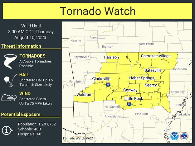 |
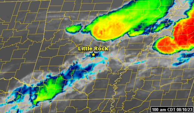
| In the picture: A Tornado Watch was posted for northern and central Arkansas late on 08/09/2023, and it continued into the wee hours of the next morning. |
|
| |
|
Back in Arkansas, we were talking about tornadoes on the 9th north of Little Rock (Pulaski County). A Tornado Watch was posted from the evening into the early morning of the 10th.
|
|
|
| |
|
Scattered severe thunderstorms developed, and unleashed a 68 mph gust just north of Mountain Home (Baxter County). Trees were downed from Mountain Home (Baxter County) to Ash Flat (Sharp County), Ravenden (Lawrence County), and Walnut Ridge (Lawrence County). Some trees blocked roadways. There was a tree on a mobile home at Hoxie (Lawrence County) as well as half dollar size hail. At an apartment complex in Armorel (Mississippi County), roof and fence damage occurred. Fortunately, there were no tornadoes.
|
|
|
| |
|
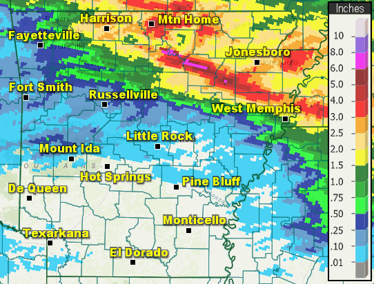
In the twenty four hour period ending at 700 am CDT on the 10th, 5.85 inches of rain was measured at Batesville Lock and Dam (Independence County)! Newport (Jackson County) received 5.37 inches of precipitation, with 4.50 inches at Mountain Home (Baxter County), 3.80 inches at Hardy (Sharp County), 3.55 inches at Salem (Fulton County), and 3.40 inches at Beedeville (Jackson County). Roads were under water at Batesville (Independence County), Diaz (Jackson County), and Newport (Jackson County).
Other significant happenings in early August included a deluge from west central into southwest Arkansas early on the 8th. Three to more than four inches of rain fell from Mena (Polk County) to Pine Ridge (Montgomery County) and Kirby (Pike County). Radar estimated hailstones up to baseball size near Shady (Polk County), although this was not confirmed.
|
|
|
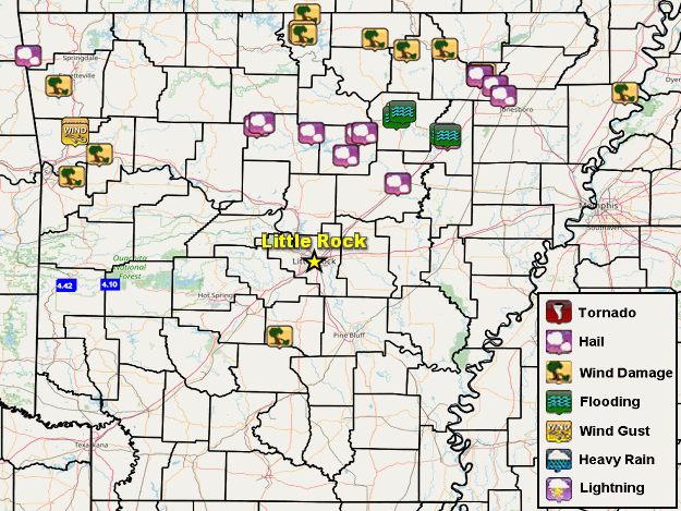
| In the picture: There were multiple reports of damaging winds/wind gusts, heavy rain, and flash flooding on August 7-12, 2023. |
|
| |
|
Early on the 11th, multiple trees were toppled onto Highway 46 between Leola and Prattsville (both in Grant County). Later in the evening, 70 to 80 mph gusts were clocked at Chester and Mountainburg (both in Crawford County). Trees fell on Highway 64 east of Mulberry (Franklin County).
|
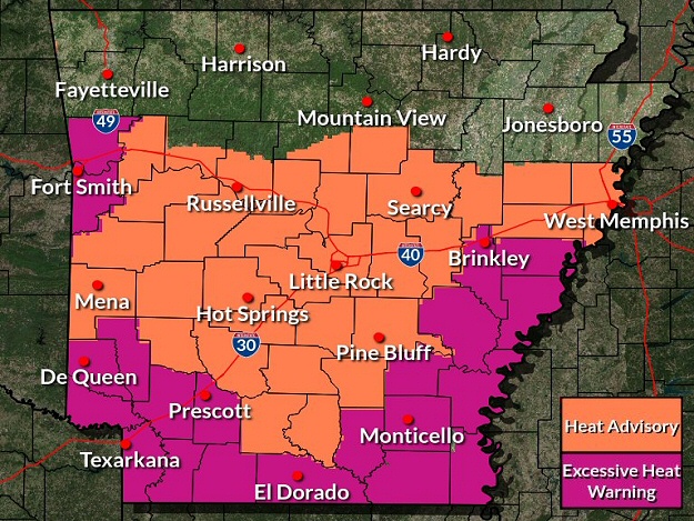 |
| In the picture: Heat headlines were in effect across central and southern Arkansas on 08/12/2023. |
|
| |
|
As the 12th rolled around, the ridge of high pressure in the Gulf of America started to build more into Arkansas. Along with it came the promise of more heat.
|
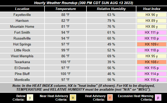 |
| In the picture: Heat index values topped 110 degrees across much of central and southern Arkansas on 08/13/2023. |
|
| |
|
On the 13th, it just was not safe to be outdoors across the central and southern counties. Temperatures were well into the 90s to around 100 degrees, and the heat index peaked between 110 and 120 degrees at many spots.
|
|
|