If there is something that may be of interest to you, we will try to make that information available.
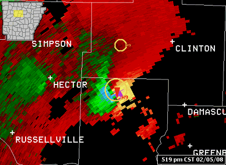
Storm Relative Velocity Map (SRM)
In the picture: The WSR-88D (Doppler Weather Radar) Storm Relative Velocity Map (SRM) image indicates strong rotation in northern Conway County between Russellville (Pope County) and Clinton (Van Buren County) at 519 pm CST on 02/05/2008. Strong inbound winds (green/blue colors) are adjacent (gate-to-gate) to strong outbound winds (red/yellow/purple colors)...indicating a lot of rotation. In fact, the radar TVS (Tornado Vortex Signature) algorithm detected a tornado...with a red triangle placed at the center of the rotation.
In a Storm Relative Velocity Map (SRM), storm motion is zeroed out so that meteorologists can get a sense of how precipitation is moving with winds inside a storm. A movement toward the radar would be inbound winds, with outbound winds headed away from the radar. Rotation is represented by adjacent (gate-to-gate) inbound and outbound winds. The concern for tornadoes increases when there is strong rotation in a deep layer (10,000 feet or more) for a prolonged period (15 to 30 minutes or more).