Are you interested in what happened during a recent event? Check out the report below.
Severe Storms on September 6-8, 2023
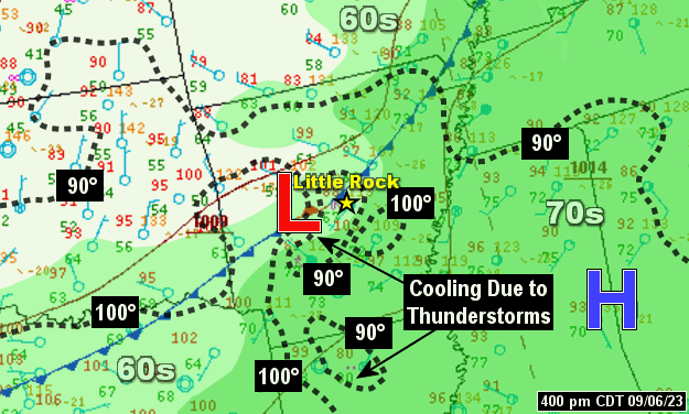
In the picture: A cold front pushed into hot and humid air across central and southern Arkansas during the afternoon of 09/06/2023. Temperatures (dashed) were well into the 90s to just over 100 degrees, and dewpoints (shaded) were in the lower to mid 70s.
It was a scorcher on September 6th. The temperature soared to 104 degrees at Mount Ida (Montgomery County) and Pine Bluff (Jefferson County), 102 degrees at Conway (Faulkner County), De Queen (Sevier County), Little Rock (Pulaski County), and Russellville (Pope County), 101 degrees at Texarkana (Miller County), and 100 degrees at Fort Smith (Sebastian County). As this was happening, a cold front was making its way through Arkansas from the northwest.
In the video: The satellite showed thunderstorms rapidly developing in central and southern Arkansas during the afternoon of 09/06/2023. The storms were along a cold front pushing through the state from the northwest.
The front triggered isolated severe storms toward the Missouri border earlier in the day (before dawn). Trees and power lines were downed at Berryville (Carroll County), with another tree uprooted to the northwest of Harrison (Boone County).
Storms redeveloped in the heat of the afternoon (by 200 pm CDT). One storm unleashed a microburst in west Little Rock (Pulaski County) that resulted in extensive straight-line wind damage (60 to 80 mph gusts) and knocked out power to 20,000 utility customers. Up to quarter size hail was reported.
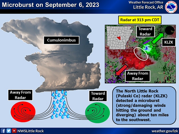
In the picture: The WSR-88D (Doppler Weather Radar) showed a classic microburst signature roughly ten miles southwest of the North Little Rock Airport (Pulaski County) at 313 pm CDT on 09/06/2023. Wind from a severe thunderstorm was driven to the ground (aided by precipitation loading/very heavy rain) and then diverged (moving toward and away from the radar).
Numerous trees were toppled or snapped, with some trees on houses. This was in the same area that was devastated by a tornado (rated EF3) on March 31st. In fact, a home destroyed by the tornado was in the process of being rebuilt, and was flattened by the microburst.
In the video: Winds picked up in a hurry in west Little Rock (Pulaski County) as a severe thunderstorm unleashed a microburst during the afternoon of 09/06/2023. The video is courtesy of Nathan Scott via X (formally Twitter).
More trees were leveled near Glen Rose (Hot Spring County) and Monticello (Drew County). There was hail to the size of quarters at De Queen (Sevier County).
7:45 AM-Rain and thunderstorms continue to move southeast across the western half of the state this morning. Some storms are capable of producing gusty winds, hail and frequent lightning. #arwxpic.twitter.com/QzPNfOZLP2
In the video: The WSR-88D (Doppler Weather Radar) showed showers and thunderstorms in the western half of Arkansas during the morning of 09/06/2023. A few of the storms became severe, and produced wind damage.
On the 7th, a 53 mph thunderstorm gust was measured at Camden (Ouachita County). Power lines were knocked down on the morning of the 8th at Alma (Crawford County). Tree and power line damage occurred between Caddo Gap (Montgomery County) and Kirby (Pike County). A few trees were pushed over east of Hope (Hempstead County) and at Prescott (Nevada County).
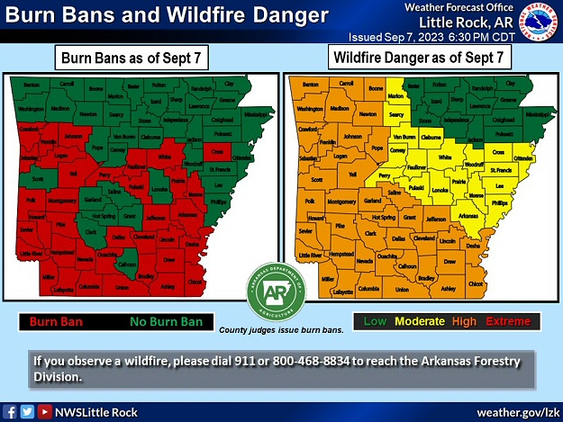
In the picture: There was a moderate to high wildfire danger in all but northeast Arkansas on 09/07/2023. Burn bans were posted in thirty six (of seventy five) counties.
Downpours were spotty in early September, and not everyone got beneficial rain. From the 6th through the 8th, Little Rock and North Little Rock (both in Pulaski County) had less than a tenth of an inch of precipitation. Pine Bluff (Jefferson County) racked up 0.14 inch. Since August 9th at these sites, a grand total of 0.65 inch, 0.46 inch, and 0.31 inch of rain fell respectively. It is no wonder that the wildfire danger was increasing, as well as the number of burn bans (posted in 36 of 75 counties as of the 7th).