 |
| Storm Reports |
| Are you interested in what happened during a recent event? Check out the report below. |
|
|
 |
A Close Call on December 8-9, 2023 |
 |
| |
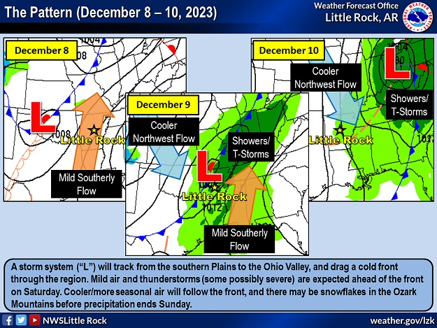 |
| In the picture: A storm system ("L") tracked from the southern Plains to the Ohio Valley, and dragged a cold front through the region in a three day period ending on 12/10/2023. Mild air and severe thunderstorms occurred ahead of the front, with cooler/more seasonal air to follow. |
|
| |
|
Severe weather (including tornadoes) was on the menu in early December (the 8th/9th). There was some uncertainty as to what exactly would happen, and where it would unfold. Parts of Arkansas were in the crosshairs, as well as neighboring states to the south/east.
|
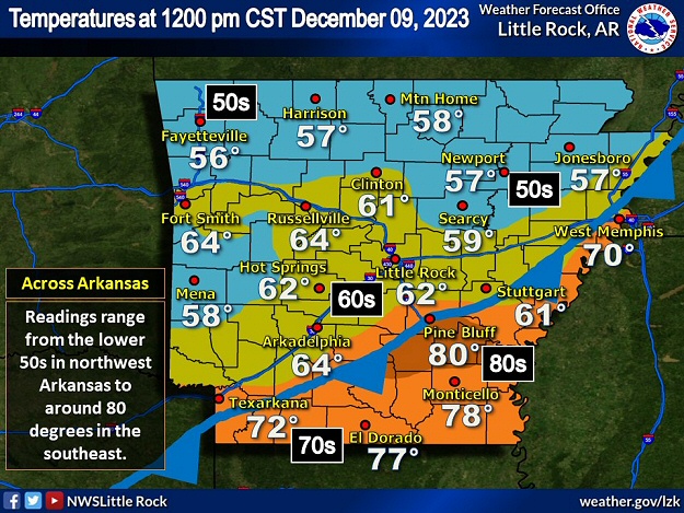 |
| In the picture: There was a wide temperature range across a cold front at 1200 pm CST on 12/09/2023. Readings ranged from the 50s/60s north of the front to the 70s to around 80 degrees farther south. |
|
| |
|
The event came in two rounds, and round one (during the evening of the 8th) was minimal. Scattered storms from western into central Arkansas downed a tree at Huntington (Sebastian County) and produced ping pong ball size hail at Mountain Pine (Garland County). Round two (during the afternoon of the 9th) had the potential to be a much bigger deal, and the focus was on the southern/eastern counties along/ahead of an advancing cold front.
|
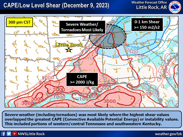 |
| In the picture: Severe weather (including tornadoes) was most likely where the highest shear values overlapped the greatest CAPE (Convective Available Potential Energy) or instability values on 12/09/2023. This included portions of western/central Tennessee and southwestern Kentucky. |
|
| |
|
While there was quarter size hail on the north side of Monticello (Drew County) and northwest of Lake Village (Chicot County), the most significant severe storms were in the Tennessee Valley. This is where the highest values of instability (warmth/moisture) and shear (turning of the wind with height) overlapped.
|
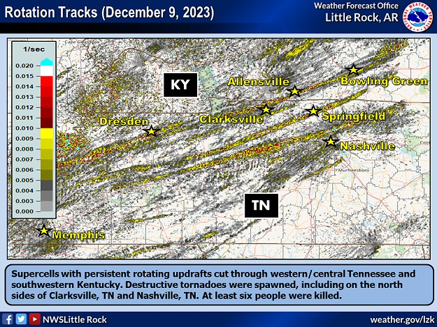 |
| In the picture: Supercells with persistent rotating updrafts cut through western/central Tennessee and southwestern Kentucky on 12/09/2023. Destructive tornadoes were spawned, including on the north sides of Clarksville, TN and Nashville, TN. At least six people were killed. |
|
| |
|
Supercells with persistent rotation developed mainly from western into central Tennessee and southwestern Kentucky. Nine tornadoes were spawned in this part of the country, and five of these were rated EF2 or higher.
|
|
|
| In the video: There was extensive damage on the north side of Clarksville, TN following a tornado (rated EF3) on 12/09/2023. The video is courtesy of Charles Peek via X (formally Twitter). |
|
| |
|
The strongest tornado (rated EF3) was on the ground for roughly forty three miles, and ripped through the north side of Clarksville, TN. Damage was extensive, and three people were killed. Just north of Nashville, TN (affecting Hendersonville, TN and Madison, TN), a tornado (rated EF2) was also responsible for three fatalities.
|
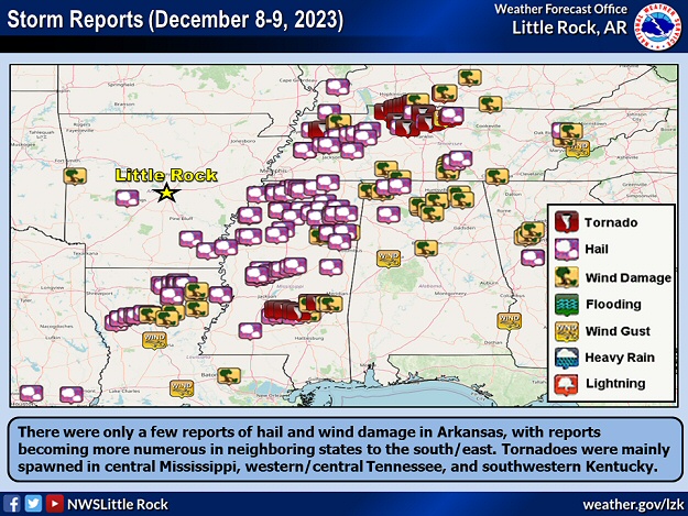 |
| In the picture: There were only a few reports of hail and wind damage in Arkansas on December 8-9, 2023, with reports becoming more numerous in neighboring states to the south/east. Tornadoes were mainly spawned in central Mississippi, western/central Tennessee, and southwestern Kentucky. |
|
| |
|
Three more weak tornadoes (rated EF0/EF1) were counted in central Mississippi. In northern sections of the state, tennis ball to baseball size hail pelted Batesville, MS and Coldwater, MS.
Interestingly, this event was not far removed (as far as geographic placement) from the tornado outbreak that took place on December, 10-11, 2021. Tornadoes during that episode were slightly farther north, were higher end (two were rated EF4), and had longer tracks (up to 165 miles). There were also a dozen tornadoes in northeast Arkansas.
|
|
|

