 |
| About This Page |
| Arkansas has had its share of historic events, many of which will be in our memories for years to come. |
|
|
 |
The Remnants of Hurricanes Rita, Gustav, and Ike (2005/2008) |
 |
| |
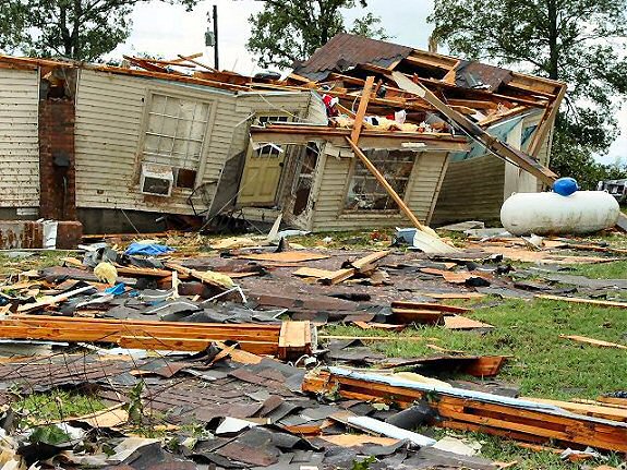 |
| Rita: Center Hill (White County) Tornado | Gustav: Highway 67/167 Flood | Ike: Cabot (Lonoke County) Tornado |
| In the pictures: A home was heavily damaged by a tornado (rated EF2) just southeast of Center Hill (White County) on 09/24/2005. Flooding was noted along U.S. Highway 67/167 (service road and one lane of the highway) between Jacksonville (Pulaski County) and Cabot (Lonoke County) on 09/04/2008. This backed up traffic for miles. A weak (rated (EF1) tornado destroyed a self-storage warehouse building southwest of Cabot (Lonoke County) 09/13/2008. |
|
| |
|
It is not every year that Arkansas is affected by a tropical system, but some systems pack a wallop. In September, 2005, it was Rita. At one point (on the 21st), Hurricane Rita had maximum sustained winds of 175 mph...a Category 5 storm! Before dawn on the 24th, Rita made landfall near the Texas and Louisiana line as a Category 3 storm (winds near 120 mph). In the couple of days to follow, the remnants of Rita brought 3 to 6 inches of rain our way. Gusts over 50 mph were reported across the southeast half of the state, with power outages at more than 60,000 households. There were also 15 tornadoes.
|
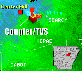 |
The tornadoes were mostly produced during the afternoon and evening hours of the 24th. Trees and power lines were downed, with some structural damage as well. Near Center Hill in White County, several buildings were damaged or destroyed by an F2 (113 to 157 mph winds) tornado. |
| In the picture: The WSR-88D (Doppler Weather Radar) indicated adjacent inbound (blue colors) and outbound (red colors) winds along with a Tornadic Vortex Signature (TVS) between Searcy (White County) and Center Hill (White County) on 09/24/2005. These are signs that a tornado might be present, with a Tornado Warning issued for the area by the National Weather Service. |
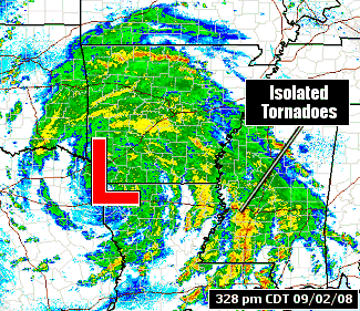
| In 2008, there were two systems. It began with the remnants of Gustav in early September. |
|
| In the picture: The WSR-88D (Doppler Weather Radar) showed rain spiraling around the remnants of Gustav ("L") in extreme northwest Louisiana at 328 pm CDT on 09/02/2008. |
| Hurricane Gustav reached the Louisiana Gulf Coast during the late morning of the 1st. The system came ashore about 65 miles southwest of New Orleans, Louisiana as a Category 2 storm with sustained winds of 110 mph. From there, Gustav moved northwest and slowed down. It weakened to a Tropical Depression by the early morning hours of the 2nd. |
|
|
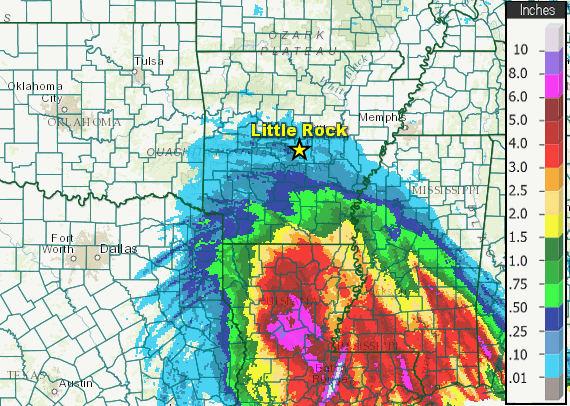
| 09/02/2008 | 09/03/2008 | 09/04/2008 |
| In the pictures: Seventy two hour rainfall (in twenty four hour increments) through 700 am CDT on 09/04/2008. Notice how slowly the precipitation built to the north with Gustav. |
|
| |
|
Given its slow movement, rain was prolonged and it added up over time. More than 8 inches of rain fell in portions of western, central and southeast Arkansas. Seventy two hour totals through 700 am CDT on the 4th included 11.50 inches at Bismarck (Hot Spring County), 11.26 inches at Leola (Grant County), 10.90 inches at Jacksonville (Pulaski County) and 10.65 inches at Hampton (Calhoun County). Widespread flash flooding was reported, with roads covered by water.
|
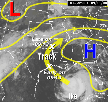 |
Less than two weeks later, Hurricane Ike made landfall along the Texas Gulf Coast early on September 13th. Ike went inland around 2 am CDT near Galveston, Texas as a Category 2 storm. Maximum sustained winds were around 110 mph. The system moved quickly toward Arkansas. |
| In the picture: Ike tracked around high pressure ("H") in the southeast United States. A storm system aloft ("L") approaching from the west quickly swept the remnants of Ike from the Texas Gulf Coast through Arkansas and into the Ohio Valley. |
| Because the system did not linger, rainfall amounts were not as heavy. However, winds were an issue, with gusts over 50 mph at times. Numerous trees and power lines were downed. Also, scattered thunderstorms popped up in rainbands swirling around the system. A few of these storms spawned weak (EF0/EF1) short-lived tornadoes, mostly in central sections of the state. A total of nine tornadoes were counted. |
|