|
| Storm Reports |
| Are you interested in what happened during a recent event? Check out the report below. |
|
|
 |
Hurricane Laura: Wind Damage, Tornadoes, and Flooding on August 26-28, 2020 |
 |
| |
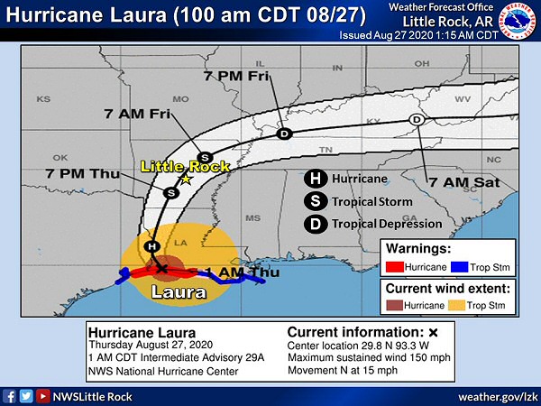 |
| In the picture: Hurricane Laura made landfall in southwest Louisiana as a Category 4 storm (150 mph sustained winds) early on 08/27/2020. |
|
| |
|
Arkansas had already been hit by one tropical system (Cristobal in early June), and another storm was coming. This one was much larger than its predecessor. Hurricane Laura rapidly strengthened on August 26th in the Gulf of America. By the time Laura reached southwest Louisiana early on the 27th, maximum sustained winds were up to 150 mph! This part of the state had never experienced such a powerful (Category 4) hurricane.
|
| Before Laura Arrived in Arkansas |
|
As Hurricane Laura approached the Louisiana Coast, a persistent cluster of thunderstorms dumped three to more than six inches of rain over a small part of western Arkansas during the morning of the 26th. This included northern Howard, western Montgomery, northwest Pike, southern Polk, and northern Sevier Counties. Due to the rain, there was flooding along Highway 84 near Langley (Pike County).
|
|
|
| In the video: Hurricane Laura was very well organized on satellite, with a well defined eye early on 08/27/2020. |
|
| |
|
Measured gusts exceeded 130 mph in Lake Charles, LA. Not only was there widespread structural damage, a television tower was destroyed and the WSR-88D (Doppler Weather Radar) at the local National Weather Service (NWS) office was obliterated. Staff at the office was evacuated prior to the arrival of Laura, with backup provided by NWS Brownsville, TX.
|
| Link of Interest |
| (courtesy of Brian Emfinger via Twitter) |
|
|
| In the video: Hurricane Laura was clearly visible on the WSR-88D (Doppler Weather Radar) in western Louisiana as of 630 am CDT on 08/27/2020. The system slowly weakened (to a Tropical Storm) before reaching Arkansas by evening. |
|
| |
|
Laura remained a hurricane well inland as the system ventured to the north at around 15 mph. Rain started building into southern Arkansas during the morning of the 27th.
|
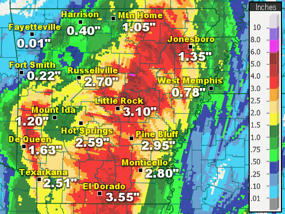 |
| In the picture: Twenty four hour rainfall as of 700 am CDT on 08/28/2020. |
|
| |
|
In the next twenty four hours (through 700 am CDT on the 28th), there was a swath of heavy rain from southern into central and northeast sections of the state, and also the far west. In these areas, two to more than five inch amounts were common. Fordyce (Dallas County) received 5.25 inches of precipitation, with 4.48 inches at Cabot (Lonoke County), 4.39 inches at Marche (Pulaski County), 4.37 inches at North Little Rock (Pulaski County), 4.17 inches at Keo (Lonoke County), 3.85 inches at Calamine (Sharp County), 3.60 inches at Stuttgart (Arkansas County), 3.55 inches at Batesville (Independence County) and El Dorado (Union County), 3.53 inches at Sheridan (Grant County), and 3.50 inches at Alicia (Lawrence County).
The atmosphere was loaded with moisture, and this created high rainfall rates. Water came down faster than it could be carried away, and roads flooded at Benton (Saline County), in North Little Rock and Sherwood (both in Pulaski County), Walnut Ridge and near Ravenden (both in Lawrence County), and a few miles east of Mena (Polk County).
Prior to Laura, it was dry from Little Rock (Pulaski County) to the northeast. Through the 26th, the dust was settled by only 0.35 inch of rain at North Little Rock (Pulaski County), 0.47 inch at Beedeville (Jackson County), 0.84 inch at Blytheville (Mississippi County), 0.91 inch at Des Arc (Prairie County), and 0.93 inch at Batesville (Independence County). A drought was ongoing in Mississippi County.
|
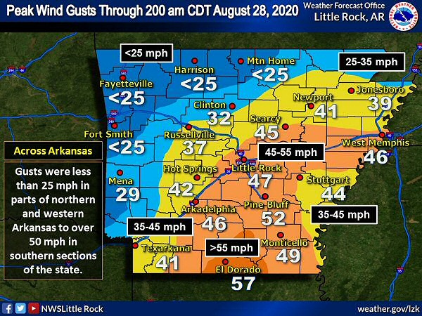 |
| In the picture: Peak wind gusts were over 40 mph in much of southern, central, and eastern Arkansas on 08/27/2020 and early the next morning. Gusts exceeded 50 mph in parts of the south. |
|
| |
|
As the remnants of Laura tracked into the state, winds kicked up and lasted for several hours. Gusts peaked at 40 to more than 50 mph in many of the same locations where rain was heavy to excessive. A 57 mph gust was measured at El Dorado (Union County), with a 53 mph gust at Conway (Faulkner County), a 52 mph gust at Benton (Saline County), the Little Rock Air Force Base (Pulaski County), and Pine Bluff (Jefferson County), a 49 mph gust at Monticello (Drew County), a 47 mph gust at Little Rock (Pulaski County), and a 46 mph gust at Arkadelphia (Clark County) and West Memphis (Crittenden County).
So much wind resulted in many downed trees and power lines, with some trees on houses. Minor structural damage was reported. There were also at least 50,000 power outages.
|
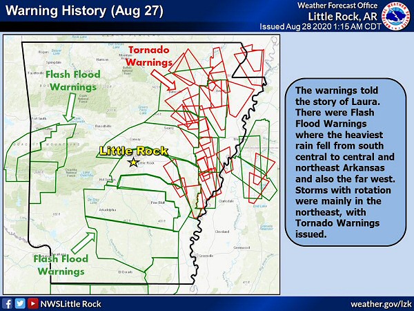 |
| In the picture: Flash Flood Warnings were posted for much of the southeast half of Arkansas and also the far west on 08/27/2020 and early the next morning. Tornado Warnings were issued in northeast sections of the state. |
|
| |
|
Inland tropical systems commonly produce tornadoes, and Laura was no exception. Rotation with storms was found mainly in rain bands north and east of the center of circulation. Tornado Warnings were concentrated in northeast Arkansas.
|
|
|
| In the picture: At least six weak tornadoes (rated EF0/EF1) were confirmed in eastern Arkansas on 08/27/2020. The information is courtesy of the National Weather Service in Memphis, TN via Twitter. |
|
| |
|
At least half a dozen weak tornadoes (rated EF0/EF1) were counted in the Memphis County Warning Area (in the northeast). Three of these were in Craighead County, with one of the tornadoes ripping up a church just west of Lake City (Craighead County). Another tornado crossed Highway 70 southwest of Forrest City (St. Francis County). The other two tornadoes were in Cross and Poinsett Counties.
|
| One Storm/Multiple Tornadoes |
|
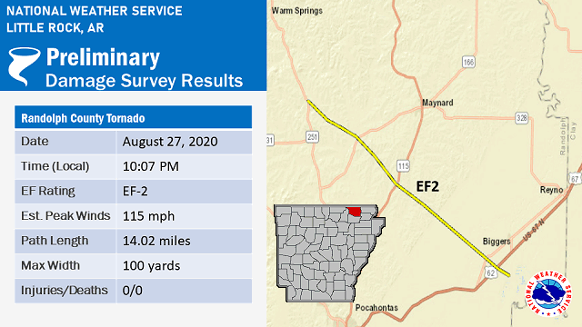
It appears one storm lasted over an hour (travelling 65 miles from southeast to northwest) and was responsible for at least four tornadoes from 855 pm to 1023 pm CDT. The tornadoes were found three miles west of Lepanto (Poinsett County), two to three miles west of Lake City (Craighead County), four miles north of Brookland (Craighead County), and from two miles south of Biggers to seven miles west of Maynard (both in Randolph County). Track the storm using the WSR-88D (Doppler Weather Radar) Correlation Coefficient (CC) product by clicking here.
|
|
|
| In the picture: A tornado (rated EF2) was confirmed from Biggers to west of Maynard (both in Randolph County) during the late evening of 08/27/2020. |
|
| |
|
In the Little Rock County Warning Area, there was a strong tornado (rated EF2) confirmed from south of Biggers to west of Maynard (both in Randolph County) during the late evening of the 27th. Outbuildings and barns were destroyed, and large sections of roof were removed from a house allowing the walls to fall inward. Fortunately, nobody was home. Weak tornado (EF0) damage was also identified three to four miles north of McCrory Woodruff County).
|
|
This was the largest August outbreak of tornadoes (eight of them) in recorded history across the state. August low pressure records were also set at multiple cities, including Harrison (Boone County), Little Rock (Pulaski County), North Little Rock (Pulaski County), and Pine Bluff (Jefferson County). The pressure readings were 29.63 inches, 29.46 inches, 29.48 inches, and 29.46 inches respectively.
|
|
|
There were numerous reports of tropical storm and non-thunderstorm wind damage, as well as isolated tornadoes and some flash flooding on August 26th and 27th. For a look at the reports, click here.
|
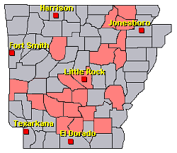
| In the picture: Preliminary reports of tropical storm and non-thunderstorm wind damage, isolated tornadoes, and flash flooding in the Little Rock County Warning Area on August 26-27, 2020 (in red). |
|
|