Are you interested in what happened during a recent event? Check out the report below.
Light Snow on January 5, 2024
In the video: A storm system ("L") arrived from the southern Rockies and southern Plains on 01/05/2024, and brought light snow to portions of northern, western, and central Arkansas. As the day progressed, precipitation transitioned to rain. The system exited to the east after dark.
Heading into January, El Niño strengthened and a parade of storm systems traversed the southern United States. The systems promised much needed moisture for drought stricken portions of Arkansas (mainly the southeast counties). Add some cold air, and now you have wintry precipitation. That is what happened on the 5th, with light snow developing during the morning in northern, western, and central sections of the state.
In the picture: Estimated snow accumulations on 01/05/2024.
A half inch up to just over three inches of snow was measured. At West Fork (Washington County), 3.5 inches of powder piled up. Cass (Franklin County) had 3.0 inches, as did Springdale (Benton/Washington Counties) and Stricker (Washington County). Areas southeast of Kingston (Madison County) and Mountainburg (Crawford County) received 2.5 inches. Several places registered 2.0 inches, including Abbott (Scott County), Botkinburg (Van Buren County), Compton (Newton County), Fayetteville (Washington County), Greenwood (Sebastian County), Mount Magazine State Park (Logan County), Mulberry (Crawford County), Ozone (Johnson County), and Tilly (Pope County).
Little Rock (Pulaski County) racked up a grand total of a trace of snow all of last winter. This event yielded 0.7 inch locally.
9:30 AM-If you have plans to head toward or away from NW Arkansas today, check @Idrivearkansas first. There are some major traffic issues caused by winter weather along I-49. Here's a look at a major problem area on I-49 near Winslow. #arwxpic.twitter.com/reJTcJm94W
In the video: Traffic was a a standstill near the Bobby Hopper Tunnel along Interstate 49 to the southwest of Winslow (Washington County) on 01/05/2023. The video is courtesy of an Arkansas Department of Transportation (ARDOT) traffic camera via IDriveArkansas.
This was considered a low impact event. Schools mostly stayed in session, and it was business as usual. Roads became slushy where snow accumulated, and there were accidents reported (such as vehicles sliding into ditches). Along Interstate 49 southwest of Winslow (Washington County), traffic temporarily grinded to a halt near the Bobby Hopper Tunnel.
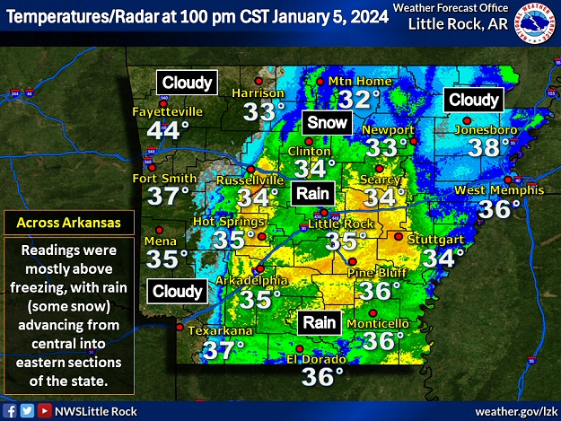
In the picture: By 100 pm CDT on 01/05/2024, precipitation (mostly rain) was trying to build from central into eastern Arkansas, and temperatures were generally above freezing.
By 100 pm CDT, temperatures slowly warmed, and snow transitioned to rain across much of the region (except parts of the north). In the west, precipitation ended altogether. Thermometers showed readings in the mid and upper 30s at many locations, and 44 degrees at Fayetteville (Washington County). Snow slowly melted, and the pavement went from slushy to wet.