 |
| Storm Reports |
| Are you interested in what happened during a recent event? Check out the report below. |
|
|
 |
Wintry Precipitation/Bitterly Cold on January 14-17, 2024 |
 |
| |
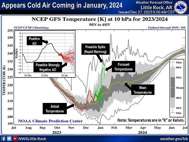 |
| In the picture: Forecast models showed significant stratospheric warming heading into January, 2024. This led to displacement of the polar vortex (located toward the North Pole), and a surge of cold air to the south. A largely positive Arctic Oscillation (AO) Index went negative, which supported a blocking pattern to our north (a weaker west to east flow in Canada), and nowhere for cold air to go but toward the mid-latitudes (where we live). |
|
| |
|
After a severe weather event on January 11th/12th, bitterly cold air poured into Arkansas from the Plains the next few days. This was the first real Arctic blast in the state since December, 2022.
|
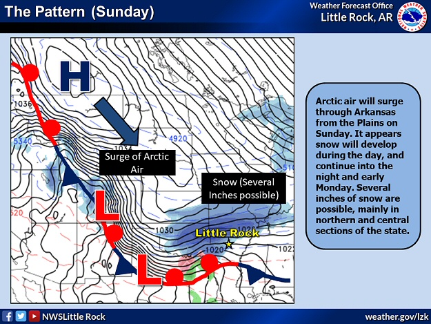 |
| In the picture: A surge of Arctic air was incoming by 01/14/2024, and there was accumulating snow expected (especially in northern and central Arkansas). |
|
| |
|
As temperatures plummeted on the 14th, snow developed in the northwest and spread across the northern half of state through the evening. Farther south, mostly sleet and some freezing rain occurred. As of 1200 pm CST, thermometers showed single digits in the Ozark Mountains, and teens and 20s elsewhere.
|
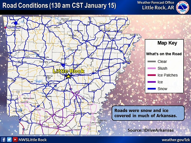 |
| In the picture: Roads were snow and ice covered across much of Arkansas as of 130 am CST on 01/15/2024. The information is courtesy of IDriveArkansas. |
|
| |
|
Roads became snow and ice covered across much of the region. During the afternoon of the 14th, a pickup truck slid off of a snowy Highway 13 and into a tree just west of Searcy (White County). The driver (a man) was killed, and his wife was injured.
|
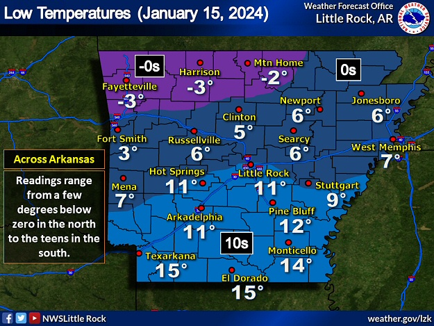 |
| In the picture: Low temperatures on 01/15/2024. Readings ranged from a few degrees below zero in northern Arkansas to the teens in the south. |
|
| |
|
By the morning of the 15th, low temperatures were below zero in the Ozark Mountains. The low was -6 degrees at Compton (Newton County), Highfill (Benton County), and Rogers (Benton County), -5 degrees at Winslow (Washington County), -4 degrees at Strickler (Washington County), -3 degrees at Fayetteville (Washington County) and Harrison (Boone County), and -2 degrees at Mountain Home (Baxter County). Elsewhere, single digits and teens were common.
|
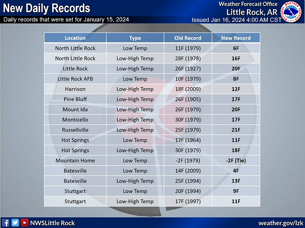 |
| In the picture: Numerous cold record temperatures were tied or broken on 01/15/2024. |
|
| |
|
Daily record lows were broken (and shattered in some cases) at several locations on the 15th including Batesville (Independence County), Hot Springs (Garland County), the Little Rock Air Force Base in Jacksonville (Pulaski County), North Little Rock (Pulaski County), and Stuttgart (Arkansas County). There were numerous record cold highs in the teens and lower 20s.
|
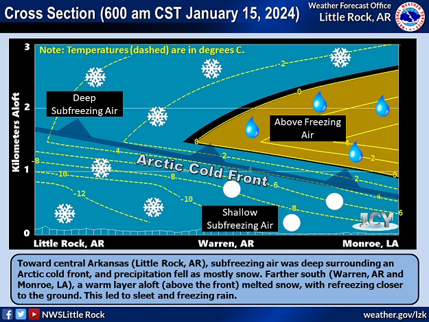 |
| In the picture: A deep subfreezing layer in northern and central Arkansas led to snow as the main precipitation type on January 14-15, 2024. Farther south, cold air was more shallow, and melting occurred aloft. Melted snow refroze closer to the ground, with sleet/freezing rain noted. |
|
| |
|
There was one more small round of wintry precipitation on the 15th. By the time this event was over, parts of northern Arkansas had more than six inches of snow (a two-day total).
|
|
|
| In the picture: After a winter with only a paltry 0.4 inch of snow a year ago, there was finally an opportunity to create a snow angle...uh...angel at the North Little Rock Airport (Pulaski County) on 01/15/2024. |
|
| |
|
Zach (Searcy County) racked up 9.5 inches of snow, with 8 inches at Culp (Baxter County) and Saint Joe (Searcy County), 7.5 inches at Brockwell (Izard County) and just southwest of Marshall (Searcy County), 7 inches near Buffalo City (Baxter County), Calico Rock (Izard County), Deer (Newton County), Melbourne (Izard County), and Violet Hill (Izard County), 6.5 inches at Cherokee Village (Sharp County), and 6 inches at Glencoe (Fulton County), a couple of miles south of Kingston (Madison County), close to Pindall (Searcy County), and at Vendor (Newton County).
|
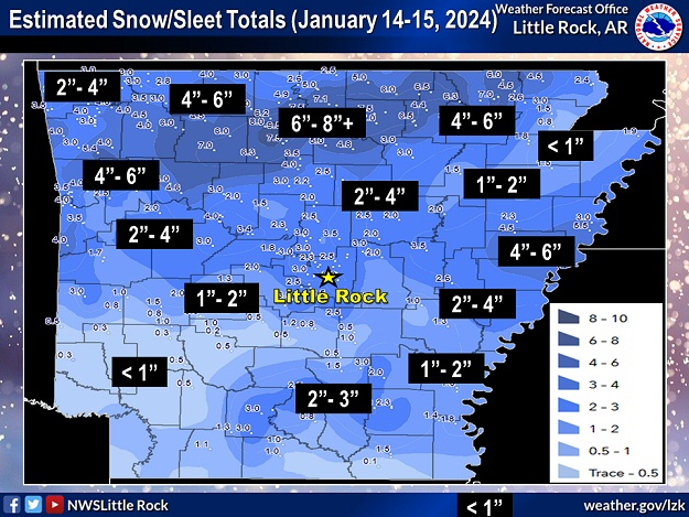 |
| In the picture: Estimated snow and sleet accumulations on January 14-15, 2024. |
|
| |
|
Toward central Arkansas, there were a lot of two to three inches accumulations. This included the Little Rock (Pulaski County) area. Across the south, a half inch to two plus inches of sleet and some snow was reported.
|
|
|
| In the picture: A couple of the coldest places on 01/16/2024 were Compton (Newton County) and Lead Hill (Boone County) with a low temperature of -7 degrees. |
|
| |
|
While the clouds went away on the 16th, the cold snap was not done. The morning began with a staggering -14 degree temperature at Gilbert (Searcy County), and -10 degrees at Fayetteville (Washington County). Compton (Newton County), Lead Hill (Boone County), and Winslow (Washington County) chimed in with -7 degrees. Even with sunshine, it was subfreezing day statewide.
|
| Putting It Into Perspective |
|
In the record books, this was a three complete day stretch (January 14-16, 2024) with temperatures below freezing at Little Rock (Pulaski County). While it sounds miserable, check this out. Back in 1983, an historic Arctic blast kept temperatures under 32 degrees from December 19th through the 30th (12 days/a record long period). In February of 2021, we dealt with eight consecutive subfreezing days (the 11th through the 18th/the third longest period on record).
|
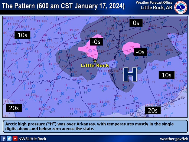 |
| In the picture: Arctic high pressure ("H") was over Arkansas at 600 am CST on 01/17/2024. Temperatures were mostly in the single digits above and below zero. |
|
| |
|
The frigid scenario carried on after dark, with single digit readings above and below zero at most sites as of dawn on the 17th. Arctic high pressure was overhead at this point (after building this way from Canada for several days), and this was arguably the most bone-chilling morning for many of us. Folks in Evening Shade (Sharp County) woke up to a -10 degree reading, and West Memphis (Crittenden County) and Jacksonville (Pulaski County) had -6 degrees and -3 degrees respectively. The 1 degree temperature at Little Rock (Pulaski County) was the coldest since February 16, 2021 (-1 degree). Before that, there was nothing that low until December 23, 1989 (-1 degree).
When the Arctic comes calling, there are usually consequences such as burst pipes and faltering water systems. Reports of water shortages were surfacing from multiple towns including Bearden (Ouachita County), Dierks (Howard County), Lonoke (Lonoke County), Mansfield (Scott/Sebastian Counties), Okolona (Clark County), Pangburn (White County), and Thornton (Calhoun County). It was a similar story in portions of Izard and Stone Counties.
During the afternoon of the 17th, temperatures climbed above freezing across most of Arkansas for the first time in three to four days (except in the east/northeast where readings stayed in the 20s to around 30 degrees).
|
|
|

