 |
| About This Page |
| Arkansas has had its share of historic events, many of which will be in our memories for years to come. |
|
|
 |
Winter Storm on December 25-26, 2012 |
 |
| |
|
|
An extremely rare event unfolded in Arkansas on December 25th (Christmas Day). Much of the region was buried under a thick blanket of heavy snow, with accumulations over a foot in some areas.
|
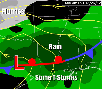
| In the pictures: A storm system ("L") brought rain and some freezing rain to begin the event on 12/25/2012, but precipitation changed to snow during the afternoon and evening. This happened as the system tracked from Texas toward the Tennessee Valley, with cold air wrapping around the back side of the system as it departed. |
|
Snow totals were the most hefty from west central into central and northeast sections of the state. Thundersnow was reported in the heavy snow band, and this led to some big amounts.
|
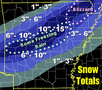 |
| In the picture: Snow totals in the twenty four hour period ending at 600 am CST on 12/26/2012. |
|
By the time it was all over (during the early morning hours of the 26th), Perry (Perry County) had 17.5 inches on the ground. Jessieville (Garland County) and Union Valley (Perry County) got 15 inches. At Houston (Perry County) and Hoxie (Lawrence County), 14 inches was measured. Judsonia (White County) and Morrilton (Conway County) had 13 inches.
|
| Heavy Snow Reports (12/26/2012) |
| Site |
Amount (Inches) |
| Perry (Perry Co) |
17.5 |
| Jessieville (Garland Co) |
15.0 |
| Union Valley (Perry Co) |
15.0 |
| Houston (Perry Co) |
14.0 |
| Hoxie (Lawrence Co) |
14.0 |
| Judsonia (White Co) |
13.0 |
| Morrilton (Conway Co) |
13.0 |
| Petit Jean State Park (Conway Co) |
13.0 |
| Batesville (Independence Co) |
12.5 |
| Austin (Lonoke Co) |
12.0 |
| Bogg Springs (Polk Co) |
12.0 |
| Mountain View (Stone Co) |
12.0 |
| Pocahontas (Randolph Co) |
12.0 |
| Vandervoort (Polk Co) |
12.0 |
| Mena (Polk Co) |
11.5 |
| Corning (Clay Co) |
11.0 |
| Mayflower (Faulkner Co) |
11.0 |
| Salem (Saline Co) |
11.0 |
| Wye (Pulaski Co) |
11.0 |
| Jacksonville (Pulaski Co) |
10.5 |
| Little Rock National Apt (Pulaski Co) |
10.3 |
| North Little Rock Apt (Pulaski Co) |
10.3 |
| Augusta (Woodruff Co) |
10.0 |
| Cabot (Lonoke Co) |
10.0 |
| Desha (Independence Co) |
10.0 |
| Gravelly (Yell Co) |
10.0 |
| Paragould (Greene Co) |
10.0 |
|
At Little Rock (Pulaski County), the last time it snowed on Christmas and it stuck (more than a trace of snow depth) was 1926! During this event, 9 inches piled up on the 25th. It was not only the most snow ever on Christmas locally, it was the 8th snowiest day on record (the snowiest was March 6th, 1875 with 12 inches). There was an additional 1.3 inches early on the 26th (for an event total of 10.3 inches).
|
| Snowiest Days in Little Rock (Pulaski County) |
| Date |
Amount (Inches) |
| March 6, 1875 |
12.0 |
| January 5, 1960 |
11.3 |
| January 18, 1893 |
11.2 |
| January 6, 1988 |
10.4 |
| December 2, 1963 |
9.8 |
| January 30, 1882 |
9.7 |
| November 17, 1880 |
9.4 |
| December 25, 2012 |
9.0 |
| February 23, 1966 |
8.5 |
| February 18, 1921 |
8.2 |
|
Across southeast Arkansas, it was too mild for much snow to develop. By the time cold air arrived, moisture was lifting (or departing) to the northeast with the storm system responsible for the snow (on its way to the Tennessee and Ohio Valleys).
|
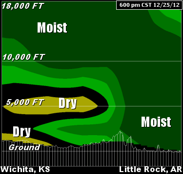 |
In the northwest counties, it was certainly cold enough for snow, but the track of the system and its available moisture was too far to the south (through northern Louisiana and central Mississippi). Shallow moisture in the northwest resulted in minor accumulations (less than an inch).
|
| In the picture: A cross section of the atmosphere from Wichita, KS to Little Rock, AR at 600 pm CST on 12/25/2012. Deep moisture on the south end of the profile led to better chances for accumulating snow than in areas farther north where drier air was in place. |
|
Available liquid amounted to just a trace at Fayetteville (Washington County) and Mountain Home (Baxter County), and only 0.01 inch at Harrison (Boone County). In the southwest, clouds dumped more than two inches of water. De Queen (Sevier County) got 2.70 inches, with 2.46 inches at Texarkana (Miller County) and 2.08 inches at Mount Ida (Montgomery County).
|
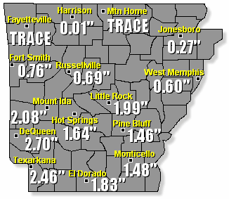 |
| In the picture: Twenty four hour precipitation (liquid) through 600 am CST on 12/26/2012. |
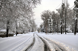 |
| In the picture: There were ruts in a few neighborhood roads in Sherwood (Pulaski County) to start the morning on 12/26/2012. Otherwise, most roads were snow covered and hazardous. Click to enlarge. |
|
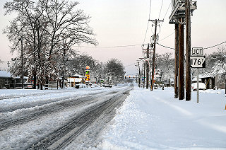 |
| In the picture: Even main arteries (like Kiehl Avenue) were tough to navigate. Click to enlarge. |
|
| |
|
There are a few other highlights that must be mentioned. In northeast sections of the state, winds gusted to more than 40 mph during the evening of the 25th. This created blizzard conditions, with visibilities dropping to a quarter mile or less due to falling and blowing snow. Such conditions were verified at Corning (Clay County) and Walnut Ridge (Lawrence County). Before the snow, the event actually began with widespread rain. Temperatures dipped to around freezing during the morning of the 25th at Hot Springs (Garland County), Little Rock (Pulaski County) and Searcy (White County). There was freezing rain for several hours at these locations, and up to a quarter of an inch of ice on trees and power lines. Snow, wind and ice knocked power out to more than 200,000 customers across Arkansas.
|
|
|
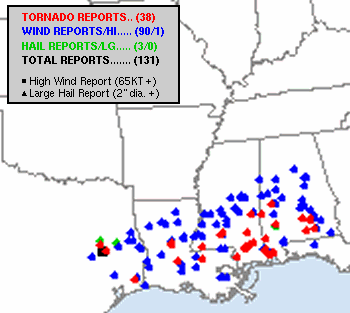
Finally, on the warm (southeast) side of the system, widespread severe weather (damaging straight-line winds and tornadoes) was noted along the Gulf Coast. There were more than three dozen reports of tornadoes in four states (especially southern Mississippi and southern Alabama).
|
| In the picture: Storm reports on 12/25/2012 and early on the 26th. The graphic is courtesy of the Storm Prediction Center in Norman, OK. |
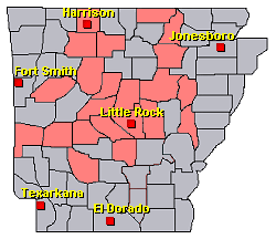
| There were numerous reports of freezing rain and heavy snow on December 25-26, 2012. For a look at some reports, click here.
|
|
| In the picture: Preliminary reports of winter weather in the Little Rock County Warning Area on December 25-26, 2012 (in red). |
|
|