
Tropical Storm Bertha could bring tropical storm conditions to portions of the Florida Panhandle and Alabama coast through Wednesday, where a Tropical Storm Watch and Storm Surge Watch is in effect. Numerous severe thunderstorms with heavy rainfall are expected from the Ohio Valley into the Mid-Atlantic and Northeast Tuesday. Read More >
Midland/Odessa
Weather Forecast Office
Thunderstorms developed during the afternoon on September 30, 2004 over the Davis Mountains and moved rapidly east-northeast into the upper portions of the Trans Pecos region and the western Texas Permian Basin. The National Weather Service Forecast Office in Midland issued Severe Thunderstorm Warnings for Reeves County at 5:31 PM and for the western portions of Pecos County at 6:44 PM.
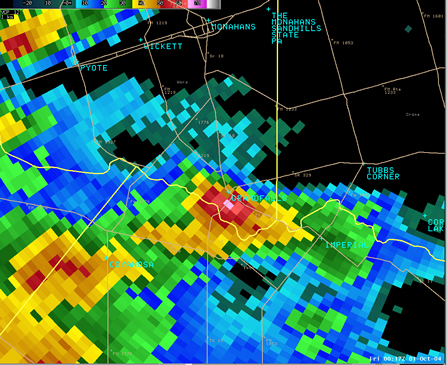
WSR-88D 0.5 Degree Reflectivity image (7:17 PM CDT) showing a severe thunderstorm moving into Grandfalls.
As severe thunderstorms continued to move rapidly east northeast at 30 mph, a Severe Thunderstorm Warning was issued for southeastern Ward County at 7:15 PM. Reports from Grandfalls indicated that the severe thunderstorm struck the community between 7:17 and 7:22 PM. Quarter to golfball size hail was reported in and just south of Grandfalls as the storm passed.
In addition, five power poles were snapped along State Route 11, just south of town. In town, an abandon mobile was rolled by high wind and destroyed while the roof of another mobile home in the southwest portions of the community was blown onto a nearby pickup. Several trees were uprooted and a historic church also sustained roof damage.
A damage survey conducted by the National Weather Service Forecast Office in Midland revealed that all damage was caused by severe thunderstorm winds. These were uniform in direction, blowing debris from the southwest to the northeast. The damaging winds swept through an area approximately three miles wide. These observations are consistent with the occurrence of a macroburst. A macroburst is a large downburst of winds extending in excess of 2.5 miles in horizontal dimension. An intense macroburst often causes widespread "tornado-like" damage, such as those that occurred in the Grandfalls area Thursday evening.
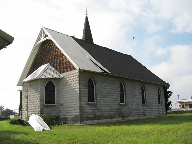
The historic church located in downtown Grandfalls suffered roof damage.
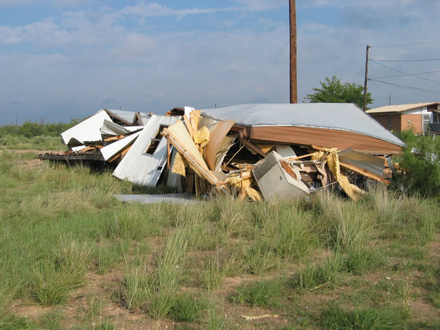
Abandoned mobile home that was destroyed in Grandfalls.
Hazards
Spotter Briefing
Outlook
Current Hazards
Storm Report
Severe Weather
Drought
Storm Prediction Center
Weather Prediction Center
National Hurricane Center
Active Alerts
Winter Weather
Past Weather
Cooperative Observations
Local Climate Data
National Climate
Current Weather
Observations
Satellite
Upper Air
West Texas Mesonet
Radar
Forecasts
Activity Planner
Aviation
Climate Prediction Center
Fire
Forecast Discussion
Graphical
Local
Space Weather Center
Information Center
Weather Trivia
Forecast Models
GIS
International Weather
Glossary
Road Conditions
Water
Hydrology
Precipitation Estimates
Quantitative Precipitation Forecasts
US Dept of Commerce
National Oceanic and Atmospheric Administration
National Weather Service
Midland/Odessa
2500 Challenger Dr.
Midland, TX 79706-2606
(432) 563-5006
Comments? Questions? Please Contact Us.

