Dangerous and extreme heat will remain across portions of the southern U.S. this week. Heavy rainfall may bring significant flash flooding across portions of the Mid-Atlantic and Northeast through the night, and additional flash flooding concerns across New England on Wednesday. Monsoonal thunderstorms will bring a flash flood risk to the Four Corners region, especially in burn scar areas Read More >
May 5, 2006 Martin County Severe Weather
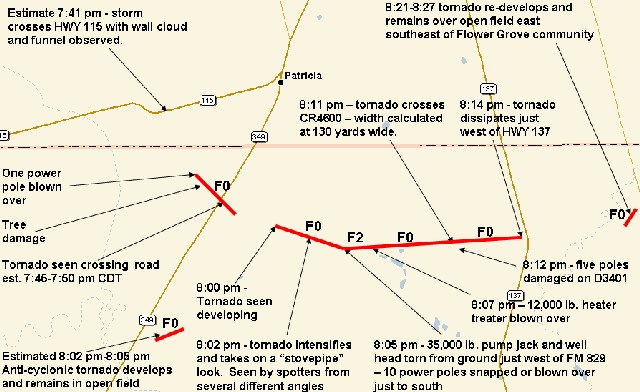
The National Weather Service in Midland has conducted a damage survey to determine the magnitude of severe weather event that occurred across portions of the WFO Midland County Warning Area on May 5, 2006. The survey team determined that a total of 5 tornadoes occurred, 1 in Gaines County and 4 in Martin County. Four of the tornadoes were determined to be weak, relatively brief, and of F0 intensity. The other tornado was determined to be a longer track tornado over Martin County, lasting approximately 14 minutes and briefly reaching F2 intensity.
The following survey summary provides specific details of the weather events that took place on May 5, 2006. The National Weather Service in Midland would like to extend a special thank you to Tim Baker, Mark Cochran, Roger Edwards,Terry Holland, John Holsenbeck, Matt Jacobs, Todd Lindley, Amos Magliocco, Greg Morgan, Brian Morganti, Kurt Mueller, Eric Nguyen, and all the spotters and storm chasers who took time to provide detailed chase accounts concerning this event in the Texas Permian Basin. Information provided was invaluable in assisting WFO Midland with this damage survey.
During the late afternoon on Friday, May 5, thunderstorms developed over Lea County New Mexico and moved northeast into portions of Gaines County. Around 5:21 pm, a thunderstorm intensified just southwest of the community of Higginbotham and began to exhibit supercellular characteristics, as the storm began moving eastward…and then finally east southward at around 20 mph.
As the cyclic supercell thunderstorm moved east southeast, it continued to intensify, producing golf ball to baseball hail in the northern and eastern portions of the city of Seminole. Matt Jacobs, meteorologist from KMID-TV Channel 2 in Midland and experienced storm chaser, viewed a field of baseball size hail while three miles east of Seminole and just south of Highway 180.
As the cyclic supercell thunderstorm continued to move east southeast, a weak and brief tornado was photographed between 7:25 and 7:27 pm over rural areas of southeast Gaines County. Due to the limited road network in southeast Gaines County, the damage survey failed to reveal any damage in southeast Gaines County. However, the tornado will be documented in the StormData publication as an F0 tornado.

Image courtesy of Matt Jacobs KMID-TV2 Midland
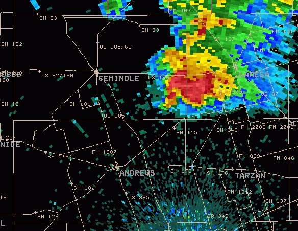
7:24 pm 0.5 Reflectivity Product from the KMAF WSR-88D
As the supercell moved across southwest portions of Dawson County, the storm occasionally exhibited a ragged wall cloud, but no tornado.
At 7:44 pm, with the storm now in northern Martin County, a weak tornado developed south of County Road 5160 and just east of County Road 2601. A power pole was blown over on CR2601 and tree damage was also noted. The tornado moved east southeast where it was visually spotted and photographed by NWS employees Todd Lindley and John Holsenbeck.

At approximately 7:45-7:50 pm, the tornado was seen crossing near the intersection of County Road 2651 and Highway 349, 4 ½ miles southwest of Patricia. Softball hail was also reported near this same intersection at 7:46 pm. At this point, the tornado became rain-wrapped as it continued to move east southeastward. Primary indications are that this tornado dissipated rapidly in open fields east of Highway 349.
There is visual evidence that the next tornado developed in open fields north of County Road D4800 and east of County Road D2651 at 8:00 pm CDT. Based on spotter reports from four separate positions in the storm, the tornado was visible at around 8:02 pm just south of County Road D4800 and west of Farm to Market Road 829, 5 ¼ miles south southeast of Patricia. The tornado, described by spotters as “shaped like a stovepipe” continued east southeast.
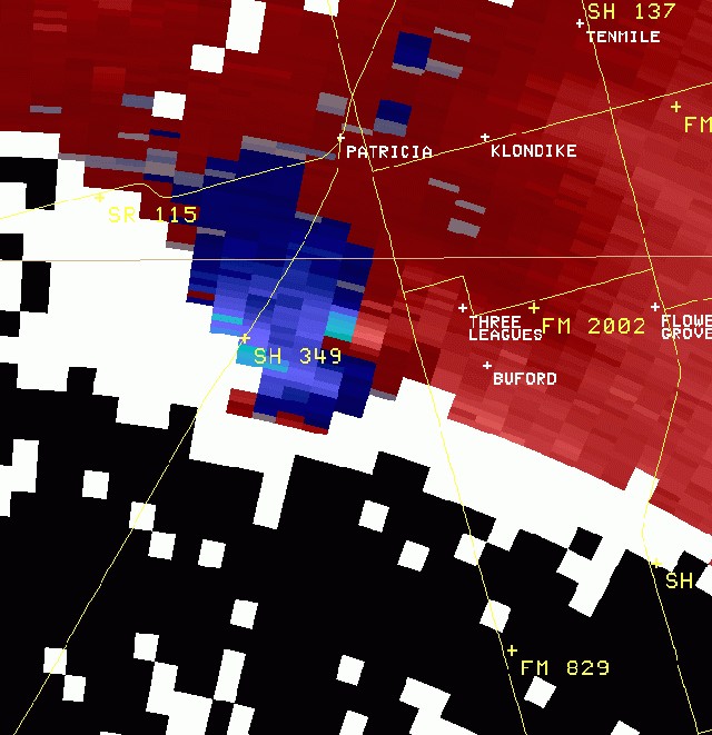
8:02 pm 0.5 SRM Product Viewed from KMAF WSR-88D

Courtesy of Amos Magliocco and Eric Nguyen 8:04 pm
At approximately 8:05 pm, along Farm to Market 829 and 5 ½ miles southeast of Patricia, the tornado pulled an oil pump jack and well head from the ground. The pump jack was estimated at 35,000 lbs. by an oil company representative. The well head was anchored in the ground by an additional 35,000 lbs of weight from pipe below the ground. From the pump jack location southward, 4 power poles along FM829 in direct path of the tornado were snapped 4-5 feet above ground level and an additional 6 poles farther south were blown over to the east due to rear flank downdraft winds. At approximately 8:07 pm, east of FM 829 and just south of County Road D4700, an oil heater treater weighing approximately 12,000 lbs. was blown over. It is believed that the damage produced by the tornado between 8:02 pm and 8:07 pm was comparable to damage of F2 intensity.
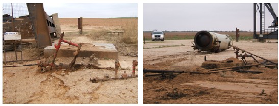
Photos courtesy of Mark Cochran
Spotter and chaser reports confirm that the tornado became rain wrapped at this point, and was not visible again until around 8:11 pm, when the tornado began taking on more of a “cigar shape” when viewed from the northwest. At approximately 8:11 pm, the tornado crossed County Road 4600, just west of D3401.

Courtesy of Roger Edwards - 8:12pm view looking north from State Highway 137
At approximately 8:12 pm, 5 power poles were knocked down on County Road D3401. Based on spotter and storm chaser information, the tornado is believed to have dissipated just west of State Highway 137 at 8:14 pm. The total track of the tornado is estimated at just over 6 miles. Based on field damage both north and south of County Road D4600, the road angle, and the storm motion, tornado width was calculated at approximately 130 yards. However, during earlier stages of the tornado’s life cycle between 8:02 pm and 8:06 pm, the tornado was seen to be slightly wider – estimated at between 200 and 300 yards wide.
The cyclic supercell thunderstorm again produced another weaker tornado between 8:21 pm and 8:27 pm. This tornado was believed to have remained over open fields until dissipating east southeast of the community of Flower Grove. This tornado will be assigned an F0 rating.
Between 8:02 pm and 8:05 pm, approximately 9 miles southwest of Patricia just east of State Highway 349, another tornado was observed by storm chasers and spotters. This tornado was observed to be anti-cyclonic in nature. Based on the tornado location in relation to the supercell thunderstorm, primary indications are that this tornado developed on the south flank of the rear flank downdraft and was also rated as being of F0 intensity. The following image was taken by storm chaser Brian Morganti:

Total damage estimates for the event have yet to be determined. The image below summarizes the tracks taken by the three tornados that occurred in Martin County.