Numerous severe thunderstorms are expected across a broad region from the Ohio Valley to the Mid-Atlantic and Northeast States today into tonight. Swaths of damaging wind gusts are expected and some tornadoes are possible. Bertha is expected to bring tropical storm conditions to portions of the Gulf Coast from the Florida Panhandle westward to southeastern Louisiana later today and Wednesday. Read More >
June 26, 2007 Severe Thunderstorm Wind Event
On Wednesday, meteorologists from the National Weather Service in Midland conducted a comprehensive study of details related to a widespread high wind event that affected a large area of west Texas and southeast New Mexico on
Tuesday evening and early Wednesday morning.
As part of this investigation, WFO Midland conducted a damage survey in and around the community of Seminole in Gaines County, where the strongest winds were reported with this event.
The survey in Gaines County provided overwhelming proof that damage across the area was caused by a derecho. A derecho is a “widespread and long-lived wind storm associated with a band of rapidly moving showers of thunderstorms.” A derecho is a type of straight-line wind event.
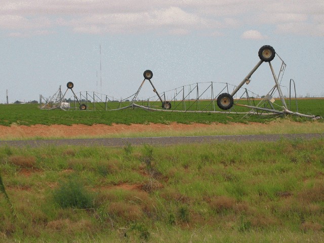
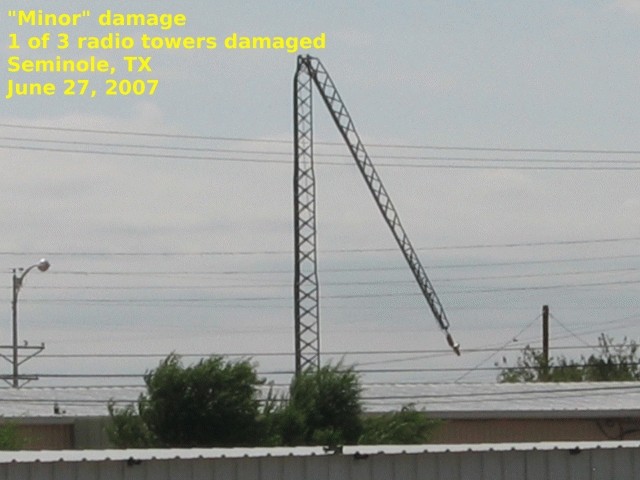
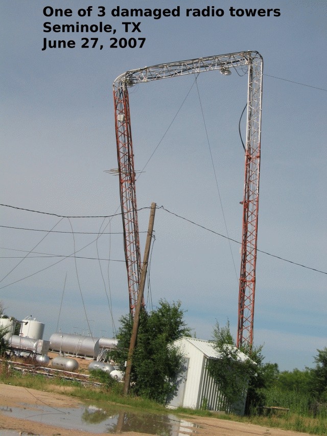
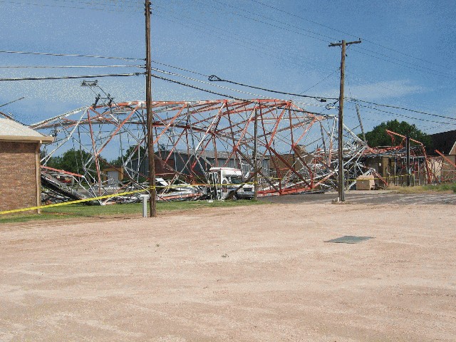
While winds were measured at 97.5 mph at the West Texas Mesonet site 2 miles north northeast of Seminole, there is visual indication that wind speeds in some locations around Seminole, were at times even stronger – estimated in the range of 100-120 mph. Communication tower damage, where a tower measuring 320 feet in height fell on a church and another tall tower was bend into the shape of a rectangle, both suggest higher wind speed estimates. Additionally, 3 miles east southeast of Seminole along County Road 402, wooden power poles were snapped just above the ground. This further supports the idea that winds were at times greater than 100 mph.
While straight-line winds are common across West Texas – especially during the late spring and early summer – the magnitude of the wind speeds for this event is quite rare. As an example, the 93 mph wind reported in Midland eclipsed the old record of 86 mph set in Feb. 1960, and was the strongest wind ever recorded in Midland since the NWS began official record keeping back in 1930.
During this long-lived weather episode, all but two of the 26 counties within WFO Midland’s CWA experienced severe weather. Many of these locations experienced high wind events, which resulted in power outages across the area. Because of backup power capability, WFO Midland was able to maintain warning operations throughout the entire severe weather event.
Many locations along and east of the mountains were affected in this event. The following are peak wind reports provided courtesy of the West Texas Mesonet...
Seminole 97.5 mph
Seagraves 75.9 mph
Andrews 59.2 mph - Some locations estimated at 70-80 mph
Other measured and estimated wind reports from across the area include...
Midland 93 mph wind gust measured at KMAF ASOS
Odessa 63 mph wind gust measured at KODO
Wink 61 mph wind gust measured at KINK
Guadalupe Pass 71 mph wind gust measured at KGDP
Big Spring 59 mph wind gust measured at BPG AWOS
Fort Stockton 66 mph wind gust measured by FST ASOS
Pecos 64 mph wind gust measured by PEQ AWOS
McDonald Observatory 70 mph wind gust
Dryden 63 mph wind gust measured by 6R6 ASOS
Tatum, NM 78 mph wind gust
Gladiola, NM Estimated 60-70 mph wind gusts
Lovington, NM 73 mph wind gust
McDonald,NM 78 mph wind gust
Carlsbad, NM 60 mph wind gusts reported
Below is a summary of the event, including images from the event and Wednesday’s damage survey in Seminole.
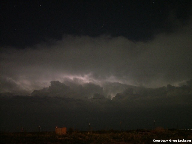
On Tuesday night and into early Wednesday morning, a strong squall associated with a frontal boundary and weak upper level disturbance moved into the forecast area causing widespread severe weather and isolated flooding. A Severe Thunderstorm Watch was issued at 6:10 PM CDT and remained in effect until 1 AM CDT and was then extended until 5 AM as the line continued to push south. Damage reports began reaching the office around 9:30 PM CDT (8:30 MDT) as the line entered the northwestern portion of the forecast area and continued until 3:30 AM CDT when the line exited the forecast area.
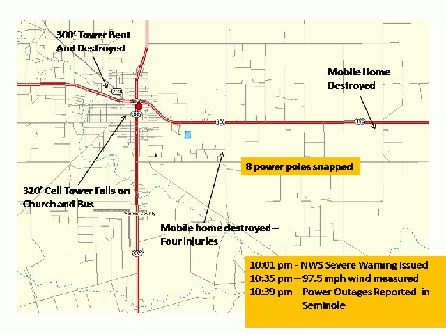
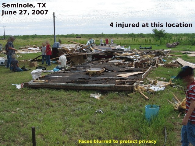
As the storm entered Lea County New Mexico, reports of wind speeds in excess of 70 mph began coming into the office. These high winds continued as the line surged forward into West Texas. In Seminole, 98 mph (measured) wind speeds toppled several radio towers including a 320 foot tower that fell on a church and bus damaging both. In addition, the roof of Beall's Department store was destroyed and two mobile homes were rolled and destroyed injuring 4 people. NWS personnel began conducting damage surveys early this morning to assess additional damage. In addition to the above, NWS personnel found many trees were uprooted and tree limbs down. The entire town of Seminole experienced damage, with areas just west of downtown and just east of town being hardest hit by the damaging winds.

As the line continued its southward progression, so did the damaging winds. Many locations began experiencing power outages including 2 of the 3 television stations in the Midland/Odessa area, and Midland International Airport. WFO Midland and the Gaines County Emergency Operation Center continued working on back up generator power until commercial power was restored to the area. Flooding also affected this area as Business 20 at FM 1788 became inundated with water and had to be closed by local law enforcement.
Emergency management officials in Odessa reported flooding in City Hall and other buildings in downtown Odessa and wind damage to buildings around the Dixie Avenue/Interstate 20 area. Over 1500 customers were without power as many power poles were damaged or destroyed throughout the city. Winds at Odessa Schlemeyer, were measured at 63 mph.
In Midland, similar damage occured with trees being uprooted and tossed about and windows being broken by the winds and debris. A 93 mph wind gust was measured at Midland International Airport just prior to the power loss, which rendered it inoperable for the remainder of the night.
The event continued into the early morning hours on Wednesday, where Dryden reported a 63 mph wind gust prior to thunderstorms exiting the area.
If you have additional questions related to this event, please call the National Weather Service in Midland at (432)563-5006.