
A heat wave over the Southwest will intensify this week, peaking and expanding into the Intermountain West and northern High Plains this weekend. Critical to extremely critical fire weather conditions are forecast from the Northwest and the northern Great Basin this weekend. Particularly Dangerous Situation Red Flag Warnings have been issued. Read More >
Midland/Odessa
Weather Forecast Office
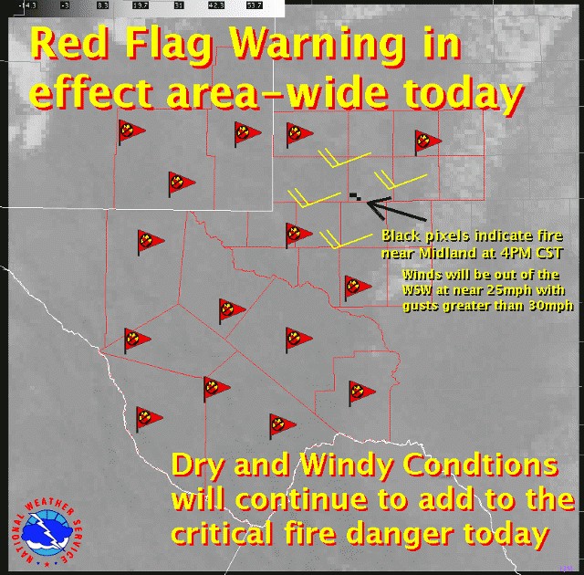
March 2, 2008 Martin County Wildfire
Unseasonably warm temperatures and very dry and windy conditions contributed to critical fire danger across much of the area.
Winds ahead of the front were sustained near 25 mph with gusts higher than 30 mph, sometimes gusting greater than 40 mph!
Sustained winds of 45 to 55 mph with gusts to near 75 mph were experienced in the mountains.
To further complicate things, snow fell across the extreme northern portions of the area and into the mountains.
Highs on Monday were considerably colder than the recent mild temperatures that have occured across west Texas and southeast New Mexico.
Hazards
Spotter Briefing
Outlook
Current Hazards
Storm Report
Severe Weather
Drought
Storm Prediction Center
Weather Prediction Center
National Hurricane Center
Active Alerts
Winter Weather
Past Weather
Cooperative Observations
Local Climate Data
National Climate
Current Weather
Observations
Satellite
Upper Air
West Texas Mesonet
Radar
Forecasts
Activity Planner
Aviation
Climate Prediction Center
Fire
Forecast Discussion
Graphical
Local
Space Weather Center
Information Center
Weather Trivia
Forecast Models
GIS
International Weather
Glossary
Road Conditions
Water
Hydrology
Precipitation Estimates
Quantitative Precipitation Forecasts
US Dept of Commerce
National Oceanic and Atmospheric Administration
National Weather Service
Midland/Odessa
2500 Challenger Dr.
Midland, TX 79706-2606
(432) 563-5006
Comments? Questions? Please Contact Us.

