A very active spring pattern with tropical concerns across the Pacific. Heavy rainfall will continue to impact Hawaii this weekend. Meanwhile we continue to monitor a developing typhoon that may affect Guam into early next week. For the Lower 48, heavy snow for mountains of California this weekend, increase threat for severe thunderstorms next week for the Plains and record warmth spreads east. Read More >
June 16, 2008 Midland Heat Burst
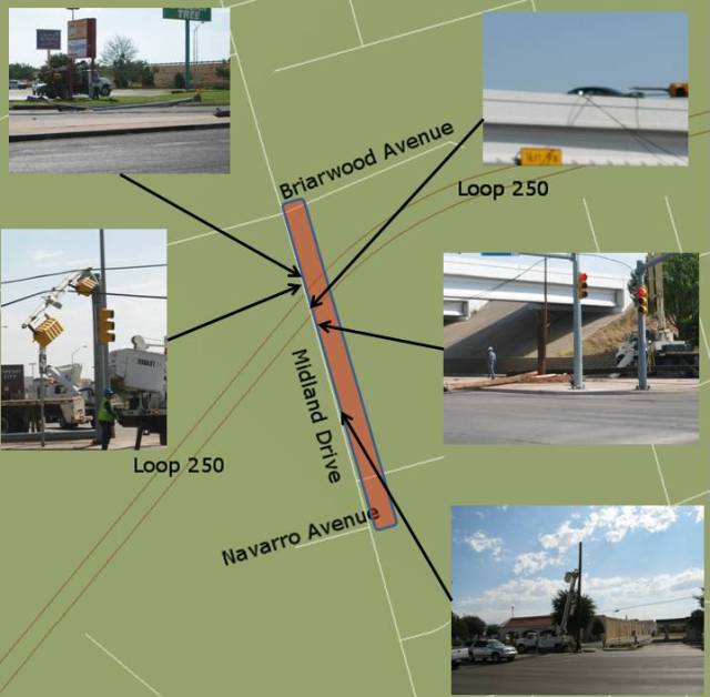
On Tuesday morning, the National Weather Service in Midland conducted a damage survey of areas within the city of Midland affected by weather during the late evening of Monday, June 16, 2008. The damage survey focused on locations at and around the intersection of Loop 250 and Midland Drive, in northwest portions of the city of Midland.

Between Briarwood and Navarro Avenues along Midland Drive, 13 power poles were damaged to varying degees. A 62 mph wind was reported at Midland Airpark on the 11:25 pm CDT observation. However, damage to wooden poles along Midland Drive was indicative of winds in the 80 to 100 mph range.
Temperature observations at Midland Airpark warmed from 86 degrees at 9:45 pm to 93 degrees shortly after midnight. Similar temperature increases were noted at Midland International Airport, where temperatures warmed from 84 degrees at 10:25 pm to 97 degrees at 11:40 pm CDT.
The presence of damaging winds and the noted temperature increase are indicative of what is termed a "heat burst". A heat burst is a downdraft of hot and dry air that typically occurs during the evening or overnight hours. In many cases, it will result in abrupt increases in temperature and a decrease in dew point temperature. Additionally, it can result in strong or even severe winds.
A heat burst can be thought of as a variation of the microburst, but with the origin of the sinking air beginning at a higher level aloft. With air sinking from a higher level in the atmosphere, there is more opportunity for warming to occur. As with any microburst, conditions are favorable for the downdraft to accelerate to the ground, and upon impact, produce an outrush of damaging wind on or near the ground.
The nature of the vertical motion makes it more difficult to detect microbursts on Doppler radar. Radar data from the WFO Midland WSR-88D doppler radar did not indicate the presence of a microburst. However, the Texas Tech Mesonet site in Seminole measured a 69 mph wind at 7:00 pm CDT, with a 68 mph wind measured at 7:40 pm at the mesonet site in Andrews. These events along with forecast discussions leading up to the event pointed to the potential for microbursts across the area.
While the worst of the damage would be considered comparable to that of an F1 tornado, there is overwhelming evidence to conclude that the Midland event was a heat burst.