
Flash flooding threatens areas from the Tennessee Valley to the Carolinas as storms repeat along a stalled front. Monsoonal storms may trigger flooding in the Southwest. Dangerous heat expands across the Desert Southwest, Plains, mid-Mississippi Valley and Southern Tier. Critical fire weather for interior Pacific Northwest. Cooler, drier air brings brief relief to the Great Lakes and Northeast. Read More >
Final Determination:
Tornado #2 ("the Notrees tornado") has been assigned a rating of EF-3 on the Enhanced Fujita Scale for tornado damage.
Special thanks is extended to Dr. Craig Miller and Dr. Greg Kopp from the University of Western Ontario, Department of Civil and Environmental Engineering, as well as to Dr. Kishor Mehta, Professor of Civil Engineering at Texas Tech University and a leading authority within the wind engineering community. James Ladue from the Warning Decision Training Branch was instrumental in bringing together these experts to assist the National Weather Service in Midland on this unique tornado damage survey.
Factoring in the design and dimension of the 320 type pump jack, as well as the concrete base construction, it was determined that the wind speed necessary to overturn the two 320 type pump jacks would be approximately 160 mph. While a formal "damage indicator" is not presently available for oil field equipment, this wind speed estimate falls at the upper end of the EF-3 scale. Evidence supports the assignment of the EF-3 rating from 1:19 pm to 1:22 pm CDT.
Early in the tornado's life cycle, between 1:16 pm and 1:18 pm CDT, significant power pole damage occurred. The snapping of the 44-foot tall "Class 3" poles at its base is indicative of EF-2 type damage, with a wind estimate in the 115-120 mph range. Power pole damage at 1:26 pm CDT, as the tornado was beginning to weaken, is indicative of EF-1 damage at around 100 mph. At this location, poles exhibited broken cross members and power poles that were snapped were of lesser strength and size. It is also apparent that the tornado continued to weaken to EF-0 intensity during the last couple minutes of its life.
The EF-3 rating for the "Notrees tornado" is historic. Indications are that this tornado is the most significant tornado to have ever impacted Ector County dating back to at least 1880 - 130 years ago. This tornado was the strongest tornado in WFO Midland's County Warning Area since the F4 Bakersfield Valley tornado, which occurred on June 1, 1990.
Background:
During the late morning on Friday, May 14, severe thunderstorms rapidly developed over western, central, and southern portions of the Texas Permian Basin and moved north northeast across a significant portion of West Texas. These storms produced widespread severe weather in the form of tornadoes, flooding, and large hail.
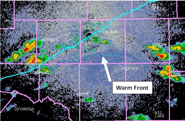
Abundant amounts of low level moisture were in place across the area Friday morning, with dew point temperatures in the 60s. A weak upper level disturbance was moving out of northern Mexico into southwest Texas, while a stronger upper level disturbance remained to the west over Arizona. It was another feature - a warm front draped over the southern portions of the Texas Permian Basin – that would become the main focus for supercell thunderstorms development across the area Friday afternoon. The image below shows the position of this frontal boundary at 7 am CDT on Friday morning.
The following radar image from 12:14 pm CDT again shows the position of this frontal boundary draped across southwest Glasscock County, southern Midland and Ector Counties, and northwest Crane County. Just 41 minutes after this image, tornado formation would occur in southeast Winkler County.
Damage Survey:
On Saturday, May 15, the National Weather Service in Midland conducted a damage survey to investigate tornadoes across extreme southeastern portions of Winkler County and western portions of Ector County.
While brief EF0 tornadoes have been confirmed in other locations – including near Greenwood, west of Crane, and in Reagan County north of Big Lake, the main focus of this write-up will be to provide documentation for tornadoes that occurred south of Notrees over western Ector County.
Determinations have been made through a combination of this NWS damage survey, along with critical storm report information received from Patrick Marsh, Paul Markowski, and Evan Bookbinder from the Vortex2 Project, Tony Laubach from Tim Samaras’s TWISTEX Group, Wesley Loyd and Anson Luna from Apache Corporation, Tom Tefertiller KWES-9, and from many others not specifically mentioned. A special thanks to all who have provided information regarding this event.
The NWS damage survey team determined the presence of three tornadoes:
Tornado #1 was viewed by Tony Laubach of the TWISTEX group. The following is an image of that tornado:
Information from Vortex2 and TWISTEX researchers indicated the presence of a “rope tornado”. SRM radar imagery showed that the thunderstorm first displayed rotation 1246 pm CDT, and then continued to show rotation on the 1251 pm and 1255 pm CDT scans. Eyewitness accounts place the beginning of tornado #1 at approximately 1256 pm CDT, approximately 12 miles northeast of Monahans in southeast Winkler County. The tornado remained a rope tornado through its entire life cycle – crossing into western Ector County, with a confirmed eyewitness dissipation time of 1:04 pm CDT. Tornado #1 will be rated as EF0.
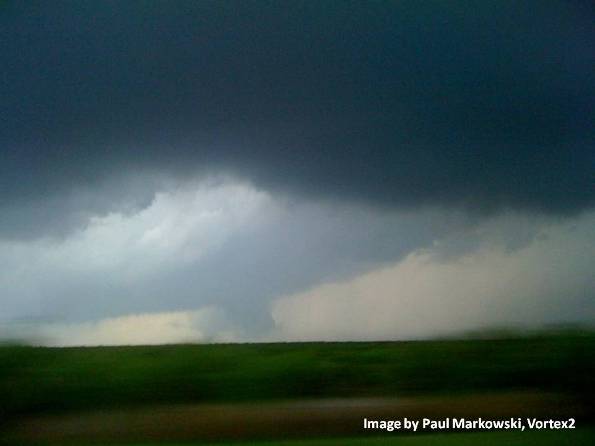
SRM radar imagery shows the development of a more significant mesocyclone east of tornado #1 beginning around 1:00 pm, 10 miles south of the Notrees community in Ector County. Subsequent SRM data shows the mesocyclone becoming more defined with each successive scan – 8 miles south of Notrees at 1:04 pm CDT, 7 miles south of Notrees and 1:09 pm CDT, and then finally 6.5 miles south of Notrees at 1:14 pm CDT. Based on the intensifying rotation, WFO Midland issued a tornado warning at 1:07 pm CDT. Tony Laubach the TWISTEX group confirmed the formation of tornado #2 at 1:15 pm. The TWISTEX group continued to follow tornado #2 as it moved north northeast until 1:24 pm CDT until finally losing view. However, others maintained view of the storm from different locations. The following image was taken at 1:19 pm CDT by researcher Paul Markowski (Vortex 2) while on Farm to Market Road 866 – looking to the west at the tornado located just over 9 miles away. It should also be noted that many different individuals witnessed this tornado. It has been referred to as the “Notrees tornado”, the “Goldsmith tornado”, and the “Gardendale tornado”.
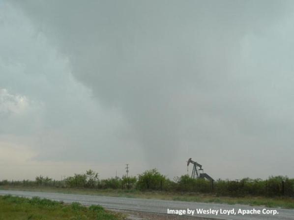
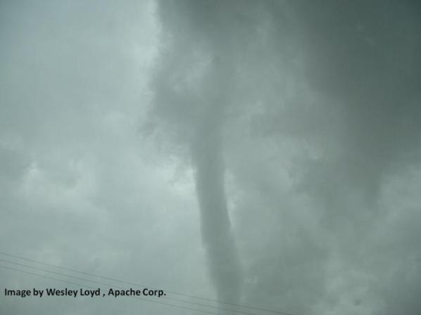
The greatest detail of the tornado was provided by Wesley Loyd of Apache Corporation. Just prior to Tony Laubach and the TWISTEX group losing a visual of tornado #2, Mr. Loyd took the following image at approximately 1:23 pm CDT when the tornado was partially obscured by rain.
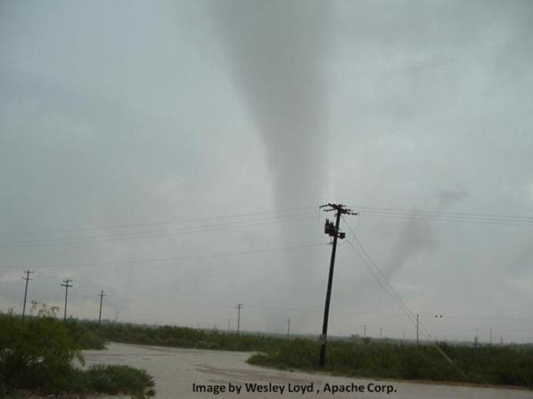
Mr. Loyd also took the following image of the tornado at approximately 1:25 pm CDT:
The tornado continued to move north northeast at almost 20 mph. Mr. Loyd was able to see the final stages of the tornado at 1:28 pm, as it dissipated on oil field property, west of Farm to Market Road 2019, south of State Highway 302, or 4.5 miles southwest of the intersection of State Highways 302 and 158. The following is the last image of the dissipating tornado taken from close range:
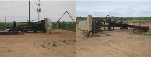
The tornado did produce significant damage to oil field equipment and power poles. Two type 320 pump jacks – each weighing 71,000 lbs. (including concrete base weight) were blown over. The following is an image of that equipment:
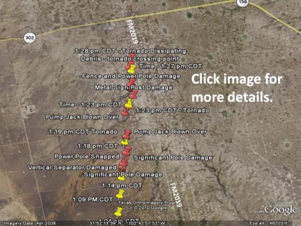
In all, the tornado lasted 13 minutes, with a path length of just over 4 miles. At its widest, tornado #2 was approximately 500 yards wide. The following Google image shows the path of the tornado (in red push pins) and mesocyclone location in yellow. Click the image for more details.
Tony Laubach, TWISTEX group, also got footage of tornado #3, looking east from State Highway 302, south of Goldsmith. Tornado #3 lasted from 1:32 pm-1:36 pm CDT. Radar imagery suggests that a new mesocyclone formed at approximately 1:27 pm CDT near the intersection of State Highway 302 and Farm to Market Road 866, 6 miles south southeast of Goldsmith. Primary indications are that by 1:32 pm CDT, when the TWISTEX research group observed the tornado, the tornado was located approximately 2 miles east northeast of the intersection of Highway 302 and FM 866, or slightly over 5 miles southeast of Goldsmith. The tornado was viewed as a rope tornado and dissipated at 1:36 pm CDT. WFO Midland issued a second tornado warning at 1:11 pm CDT, providing 21 minutes lead time for this third tornado. Tornado #3 will be rated as EF0.


