
Dangerous heat will expand from the Gulf Coast into the Southern Plains and Desert Southwest through week's end. Additional extreme heat impacting the Pacific Northwest will shift to the northern Plains by the weekend. Tropical Storm Bertha is expected to continue to impact portions of the northern Gulf Coast from the western Florida Panhandle to southeastern Louisiana through tonight. Read More >
Gregory P. Murdoch
1. Introduction
Forecasting the possibility of tornadic supercells has been focused on the 0-3 km storm-relative helicity (SRH) (Davies-Jones et al. 1990), the 0-6 km vertical wind shear (VWS) (Weisman 1996) or by using a combination of SRH and thermodynamic parameters like the Convective Available Potential Energy (CAPE) (Johns et al. 1993). However, recent research suggests that mid-level storm-relative (SR) winds play a significant role in determining whether or not a supercell may become tornadic (Thompson 1998). Conceptually, the work of Thompson (1998) is based on the idea that a balance between the rain-cooled outflow and the storm inflow is needed for the production of multiple or long-lived supercell tornadoes.
Thompson (1998) analyzed 131 supercell cases across the contiguous United States in which he used the surface, 500 mb (or mid-level), and 250 mb SR winds to distinguish between tornadic and nontornadic supercells. He found that the 500 mb SR winds performed best as an indicator of the possibility of tornadic supercells. Further, he determined that a lower bound of 8 m s-1 was needed for the development of tornadoes with an upper bound around 19 m s-1. Conceptually, it is argued that SR winds lower than 8 m s-1 are not sufficient to carry heavy precipitation away from the updraft resulting in the evolution of excessive rain-cooled outflow in the low levels of the storm, in close proximity to the updraft area. Davies-Jones and Brooks (1993) suggest that this excessive outflow overwhelms the warm, moist inflow, and essentially "undercuts" the low level mesocyclone; hence, minimizing the tornadic potential of the storm. SR winds greater than 19 m s-1 appear to carry too much precipitation away from the updraft inhibiting the formation of the rain cooled outflow along the rear flank of the supercell which is the likely source of horizontal baroclinic vorticity that is needed for the development of the low level mesocyclone (Davies-Jones and Brooks 1993). Finally, Thompson (1998) suggests that when the 500 mb SR winds are between 8 m s-1 and 19 m s-1 a balance may exist between the rain-cooled outflow and storm inflow which favors the development of multiple or long-lived tornadoes.
Mead (1997) lends further support to the concept of mid-level SR winds producing an environment favorable for tornadic supercells. He suggests that mid-level SR winds, when used with thermodynamic parameters like CAPE or even used in combination with the Energy Helicity Index (EHI) (Davies 1993), provide a significant measure of skill in forecasting environments favorable for the development of tornadoes, given that convection is realized.
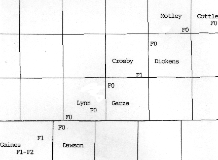
The concept of using mid-level SR winds as an indicator of tornadic potential was applied to a case in which a tornadic supercell developed over Gaines County, Texas (Fig. 1) on 10 April 1997. This paper will describe the synoptic setting and discuss how well the 12 and 24 hour forecast from the Eta model suggested the likelihood of tornadic supercells using the threshold values of 500 mb SR winds found by Thompson (1998).
 |
2. The Gaines County Texas Tornado and Synoptic Setting
At 2140 UTC on 10 April 1997 a strong mesocyclone developed southeast of Seminole, Texas in Gaines County. It then subsequently moved northeast at 20 kts. By 2221 UTC the first of a series of F0 to F2 tornadoes was spawned east of Seminole, Texas. This tornadic thunderstorm exhibited multiple mesocyclone evolutions for the next six hours producing multiple tornadoes as it traveled northeast for approximately 90 km killing one person and causing significant damage before dissipating in Cottle County, Texas (Fig. 1) . This supercell was extremely well documented by storm chasers.
The potential for supercells was recognized early the morning of 10 April 1997 with the dryline forecast near the eastern New Mexico/Texas border during the afternoon. Coincident with the dryline were progged CAPE values to 2000 J kg-1 with meager 0-3 km SRH values near 80 m2 s-2.
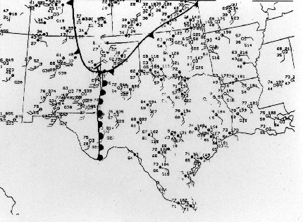
At 2000 UTC a strong baroclinic surface boundary was pushing south through eastern New Mexico and into the Texas South Plains with a well defined dryline positioned along the eastern New Mexico/Texas border (Fig. 2) . Surface flow south of the cold front and east of the dryline was especially impressive with Midland reporting sustained southeast winds at 25 kts. Convergence along the dryline was maximized in the vicinity of the surface low near Clovis, New Mexico while a modified KMAF hodograph suggested the 0-3 km SRH had increased to 170 m2 s-2 . Temperatures east of the dryline were climbing to near 26 degrees C with dewpoints around 15 degrees C leading to CAPES in excess of 2000 J kg-1 and lifted indices to minus 7 degrees C. Weak differential vorticity advection was spreading into West Texas with steep mid-level lapse rates in place (8 degrees C km-1 between 700 mb and 500 mb). Jet stream dynamics were noticeably absent with the strongest winds near the mid-level trough axis.
 |
3. Eta 12 and 24 hour Mid-level Storm-Relative Wind Forecast
The 48 km resolution Eta model was used along with some modified versions of SR wind and SRH macros for PC-GRIDDS developed by the Storm Prediction Center. The storm motion was calculated using a motion 30 degrees to the right and 75 percent of the 700 mb wind.
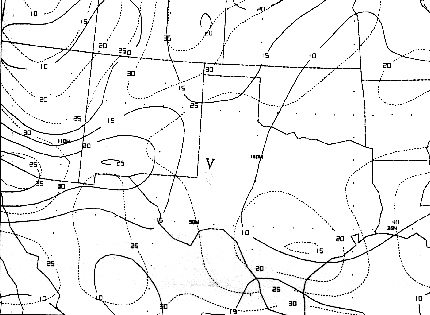
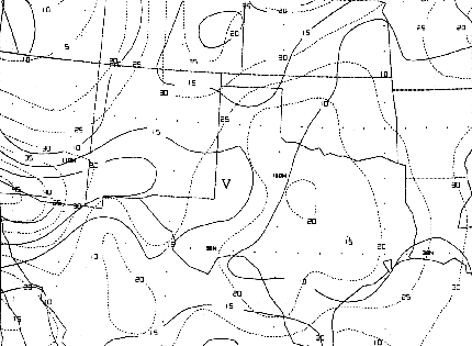
The 24 hour Eta forecast from the 0000 UTC 10 April 1997 model run showed a 500 mb SR wind of 13 m s-1 which is extremely close to the mean 500 mb SR wind Thompson (1998) found in his tornadic cases (Fig. 3). The 12 hour Eta forecast from the 1200 UTC 10 April 1997 run showed a 500 mb SR wind of 16 m s-1 which is approaching the upper bound of 19 m s-1, but still well within the range Thompson (1998) found to be indicative of tornadic supercells (Fig. 4). In fact, 85 percent of the tornadic supercell events in Thompson (1998) occurred in environments where the forecast 500 mb SR winds were greater than 8 m s-1. This cyclic tornadic supercell that developed in Gaines County lends further support to Thompson (1998) as both the 12 and 24 hour 500 mb SR wind forecast fell within the diagnostic and prognostic range of 8 m s-1 to 19 m s-1.
 |
 |
4. Conclusion
The concept of applying mid-level SR winds to better forecast the possibility of tornadoes is a technique that can be easily applied in the operational setting of the National Weather Service. This case study further validates the extensive study conducted by Thompson (1998) that suggests, given that supercells develop, the 500 mb SR winds between 8 m s-1 and 19 m s-1 can provide a means of distinguishing between the possibility of tornadic and nontornadic supercells.
Both the 12 and 24 hour forecast from the Eta model under-forecast the 0-3 km SRH values at 0000 UTC 11 April 1997 with values to 80 m2 s-2. In contrast, the 500 mb SR wind Eta forecasts were consistent keeping the 500 mb SR winds between 13 m s-1 and 16 m s-1 which is within the range Thompson (1998) suggests is needed for tornadic supercells. It can be argued that the 500 mb SR wind forecast will typically be more consistent and reliable than the 0-3 km SRH forecast due to the complex and rapidly changing nature of surface and low level mesoscale features that can impact SRH .
Modifying the Midland hodograph for conditions near the time the first tornado developed revealed that storm-relative inflow increased with 0-3 km SRH values nearing 170 m2 s-2. This suggests forecasters should not focus on a single level, parameter, or philosophy but would be better served incorporating a combination of forecasting techniques including: 0-3 km SRH, 0-6 km VWS, 700 mb and 500 mb SR winds, and applying current data and any anticipated changes into the analysis and prognosis to better determine if the possibility of tornadoes exists.
Acknowledgments
The author would like to thank Brian Francis and Loren Phillips, SOO's at Midland and Lubbock, respectively as well as T.J. Turnage and Corey Mead, forecasters at Midland and Omaha, respectively for their helpful comments and reviews.
References
Davies, J. M., 1993: Hourly helicity, instability, and EHI in forecasting supercell tornadoes. Preprints, 17th Conf. on Severe Local Storms, Saint Louis, MO, Amer. Meteor. Soc., 107-111.
Davies-Jones, R., and H. E. Brooks, 1993: Mesocyclogenesis from a theoretical perspective. The Tornado: Its Structure, Dynamics, Prediction and Hazards, Geophys. Monogr., No 79, Amer. Geophys. Union, 105-114.
Davies-Jones, R., D. Burgess, and M. Foster, 1990: Test of helicity as a tornado forecast parameter. Preprints, 16th Conf. on Severe Local Storms, Kananaskis Park, Alberta, Canada, Amer. Meteor. Soc., 588-592.
Mead, C. M., 1997: The Discrimination between Tornadic and Nontornadic Supercell Environments: A Forecasting Challenge in the Southern United States. Wea. Forecasting, 12, 379-387.
National Climatic Data Center, 1997: Storm Data, Vol 39. National Oceanic and Atmospheric Administration.
Thompson, R., 1998: Eta Model Storm-Relative Winds Associated with Tornadic and Nontornadic Supercells. Wea. Forecasting, 13, 125-137.
Weisman, M.L., 1996: On the use of vertical wind shear versus helicity in interpreting supercell dynamics. Preprints, 18th Conf. on Severe Local Storms, San Francisco, CA, Amer. Meteor. Soc., 200-204.

