Coastal Waters Forecasts With Wave Detail
The NWS, through the improved Coastal Waters Forecast (CWF) product, will be providing enhanced wave height, direction and period information in marine forecasts this Spring (see Service Change Notice). Detailed wave forecasts provide additional information regarding wave components (including differing direction and period) in addition to still providing pre-existing forecasts of significant wave height. Please see our Coastal Waters Wave Detail Videos I, II, III, IV and downloadable reference pages for the East Coast / Gulf Coast and West Coast / Pacific Region to learn more.
| Wave Detail Overview | Wave Detail Reference (Click Images Below) | |
 |
 |
 |
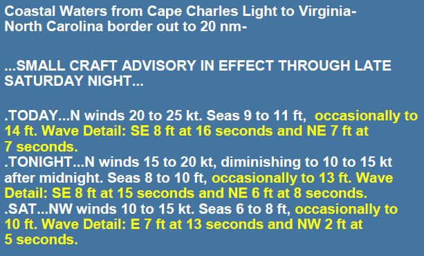
| Coastal Waters Forecast with Wave Detail (new wave detail highlighted in yellow) |
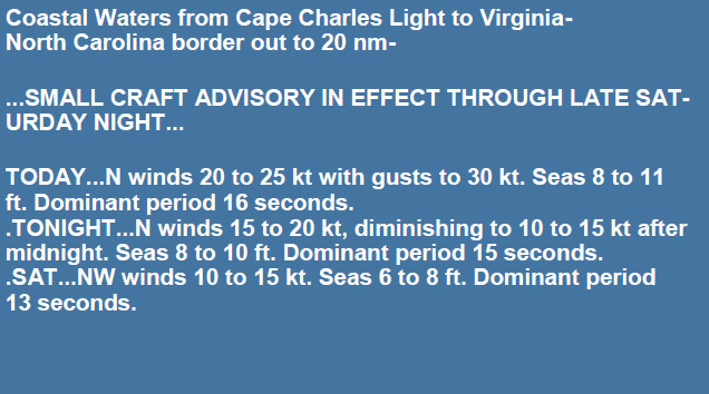
Previous Version of Coastal Waters Forecast | |
 |
 |
There are three fundamental properties of ocean waves: height, period, and direction. Wave height generally refers to how tall a wave is from trough to crest, wave direction is the direction the wave is coming from, and wave period is the time it takes for successive waves to pass a fixed point, such as a buoy. The period is also directly related to how fast waves move, how deep they extend into the ocean, how much energy they contain, which, in turn, influences the size of breaking waves at the coast, and more.
In addition, it is common for there to be multiple, coexisting wave groups that coincide at any given point in the ocean. Some users may only be interested in short period waves because they present hazardous, choppy waves for smaller boats, others may take particular interest in the long period waves given the shoaling hazards they create near shore, while others may be interested in both. The point is, no two wave systems are created equal, any wave system present may be hazardous or of interest to different marine groups, and therefore we feel we should not ignore them.
New Wave Detail Forecasts go beyond providing just provide significant wave height, defined as the average height of the highest one third of all waves at a particular point or region in the ocean. Significant Wave Height remains a fundamental variable of the sea state that our customers will continue to see referenced in forecasts. Additional Wave Detail supplements the Coastal Waters Forecast with wave detail describing differing wave directions and period in addition to maximum wave height.
Here are some training and videos on Understanding Wind Waves and Swell Waves. You can dive deeper into enhanced wave forecasts with the Real Time Near Shore Wave Prediction System. Dive deeper into enhanced wave forecasts with the Real Time Near Shore Wave Prediction System.
| Video Simulation of a Sailboat in Confused Seas | Video Simulation of Differing Wave Directions |
 |
|
There will be a phased implementation by each NWS Region for the wave component detail in the Coastal Waters Forecast: |
|
| Eastern Region WFOs and WFO Honolulu: | April 15 - April 26 |
| Southern Region WFOs: | April 29 - May 10 |
| Western Region WFOs: | May 13 - May 24 |
| WFO Guam | November 2024 |
On the map below, you can scroll left or right or up and down to show all marine forecast offices; then zoom and click on an area of interest (different offices represented by different colors). Click on the image in the popup to see that particular office's coastal waters forecast with enhanced information. Offices will be added to the map as they start issuing wave detail forecast.
Additional Resources & Education
Coastal Waters Wave Detail Videos I, II, III, IV
Ocean Waves—JetStream Weather School
MetEd—Wave Types and Characteristics,
Wave Life Cycle 1: Generation,
Wave Life Cycle 2: Propagation & Dispersion,

