1. Where can I find a marine forecast on the Internet?
3. How can I get a marine forecast via E-mail?
4. I am having trouble with NWS ftp or web services, what can I do?
5. Where can I get information on current marine weather conditions and the tide?
7. Where can I find Sea Surface Temperature (SST) and Gulf Stream information on the Web?
9. Is the voice I hear on NOAA Weather Radio a computerized voice or a real person?
12. How can I access the Internet or exchange E-mail while at sea?
13. It seems like I wait forever to hear a marine forecast on NOAA Weather Radio. What's being done?
15. When the marine forecast says "seas 3-5 ft", what exactly does that mean?
16. Your marine forecast for my area was way off last weekend. What happened?
18. How do I convert knots(kt) to mph, etc?
19. What is the "1-2-3 Rule" used for hurricane avoidance?
20. Why must some radio receivers be tuned 1.9 kHz lower than the assigned frequency to receive radiofax transmissions?
21. Why does my radiofax reception appear to be so poor? Can't the Coast Guard increase the power?
22. How can I send in a broadcast reception report from a US Coast Guard Station and request a QSL card from the US Coast Guard?
24. Where can I get a marine forecast for areas outside of the NWS' area of responsibility?
29. What is a "Marine Zone Forecast"? What is a "Marine Point Forecast"?
30. Do you have any mobile weather apps?
31. Where can I get tsunami information?
32. Where can I get information about volcanic ashfall and its effects on marine navigation?
1. Where can I find a marine forecast on the Internet?
Go the National Weather Service's NWS Marine Weather Services homepage. This page also provides links to Weather Forecast Offices and National Centers which provide links to their marine weather products, as well as additional regionally focused information such as buoy observations and tide predictions.
The Marine Forecasts - Products Via Internet webpage provides details on where to find marine related weather products, publications and information on the Internet. This webpage also provides links to Foreign Meteorological Services and Computer Generated Model Guidance which includes data which is outside the area of U.S. marine forecast responsibility. See also FAQ #23 for areas outside U.S. waters.
2. How can I get a marine forecast or buoy observation over the phone and how do I read a station plot of buoy data ?
Most National Weather Service offices keep an updated recording of the forecasts they produce and can be accessed by phone. To find the phone number of the office near you, check your telephone directory under "United States Government, Commerce Department, National Weather Service." A listing of Weather Service Offices with marine recordings is also available. The National Data Buoy Center's Dial a Buoy Service was discontinued March 17, 2024. For more information, see our Service Change Notice.
This website explains how to read a station plot of buoy data.
3. How can I get a marine forecast via E-mail?
To get started in using the NWS FTPMAIL service, follow these directions to obtain the FTPMAIL "help" file, or click on this link: https://weather.gov/media/marine/ftpmail.txt
| -In plain text format- | |
| Send an e-mail to: | NWS.FTPMail.OPS@noaa.gov |
| Subject line: | Put anything you like |
| Body: | help |
Caution - Read the help file carefully - 99% of errors using FTPMAIL are simple typo's, incorrect capitalization, failure to send in plain text format, leading or trailing spaces, or failure to set up any spam filters properly.
A webpage describing several different e-mail "robots" similar in concept to FTPMAIL, including some with advanced features such as allowing retrieval of NWS marine GRIB files, simple webpages, and allowing products to be retrieved on a scheduled, recurring basis may be found at: https://www.weather.gov/media/marine/robots.txt. This webpage may be retrieved via FTPMAIL as follows:
| -In plain text format- | |
| Send an e-mail to: | NWS.FTPMail.OPS@noaa.gov |
| Subject line: | Put anything you like |
| Body: | open cd fax get robots.txt quit |
Links to important text files for using FTPMAIL. The files linked below are up to date. If you request these same files from the FTPMAIL server, they will likely not be up to date. We suggest you click on the links below for the latest files.
ftpcmd.txt (List of FTPMAIL commands)
rfaxtif.txt (TIFF suggestions)
rfaxatl.txt (Atlantic radiofax file directory)
rfaxpac.txt (Pacific radiofax file directory)
rfaxmex.txt (Gulf of America and Trop Atl radiofax file dir)
rfaxak.txt (Alaska radiofax and ice file directory)
rfaxhi.txt (Hawaii radiofax file directory)
otherfax.txt (Foreign charts file directory)
marine1.txt (Highseas,Offshore,Open Lakes,NAVTEX text file dir)
marine2.txt (Hurricane text file directory)
marine3.txt (Coastal and nearshore forecasts text file dir)
marine4.txt (Offshore forecasts by zone directory)
marine5.txt (Atlantic coastal forecasts by zone directory)
marine6.txt (Pacific coastal forecasts by zone directory)
marine7.txt (Gulf of America coastal forecasts by zone dir)
marine8.txt (Great Lakes nearshore forecasts by zone directory)
marine9.txt (Alaska coastal forecasts by zone directory)
marine10.txt (Hawaii&Trust coastal forecasts by zone directory)
uk.txt (UK marine forecasts from Bracknell directory)
canada.txt (Canadian marine text forecast directory)
tsunami.txt (Tsunami products directory)
buoydata.txt (Buoy and C-MAN station observations directory)
robots.txt (Marine forecasts and info via e-mail systems)
Not all NWS forecast products are available via the tgftp.nws.noaa.gov FTP server and therefore accessible via FTPMAIL such as worldwide computer generated model forecasts which include areas beyond the area of U.S. forecasting responsibility such as the Indian Ocean and South Atlantic. To retrieve Wave Watch III (http://polar.ncep.noaa.gov/waves/product_table.shtml?-multi_1-) and other forecasts via e-mail, use one of the www-to-email systems described in "robots" above. Be aware computer generated products from forecast models are not reviewed by forecasters and are therefore subject to error.
The electronic version of the Worldwide Marine Radiofacsimile Broadcast Schedules publication now contains links to FTPMAIL commands.
4. I am having trouble with NWS ftp or web services, what can I do?
NWS FTP/HTTP Services for obtaining Weather Data and Products: https://www.weather.gov/tg/dataprod
NWS Web Services: https://www.weather.gov/gis/WebServices
5. Where can I get information on current marine weather conditions and the tide?
Listen to NOAA Weather Radio, see the webpage of your local Weather Forecast Office, or the National Data Buoy Center (NDBC). Current buoy and C-MAN observations may also be obtained by phone via NDBC's "Dial-A-Buoy" service.
Predicted Tides, Currents, Water Levels and Lake Levels are available on the National Ocean Service's Tides and Currents webpage
6. Where can I get copies of old (archived) forecasts, including radiofax charts, or find climatological information?
Unofficial NWS marine forecasts and other products can be found on the Iowa Environmental Mesonet from Iowa State University.
Official NWS marine forecasts and other products must be ordered from the National Center for Environmental Information. See contact information below.
For Official Weather and Satellite Data Contact:
National Center for Environmental Information (formerly known as the National Climatic Data Center)
151 Patton Avenue
Asheville, NC 28801-5001
828-271-4800
828-271-4876 (FAX)
ncdc.orders@noaa.gov
https://ncdc.noaa.gov
For Historic Oceanographic Data Contact:
National Oceanographic Data Center
User Services
NOAA/NESDIS E/OC1
SSMC3, 4th Floor
1315 East West Highway
Silver Spring, MD 20910-3282
301-713-3277
301-713-3302 (FAX)
NODC.Services@noaa.gov
https://www.nodc.noaa.gov
For OPC Product Archives, Including Radiofax Charts:
Go to this webpage: https://ocean.weather.gov/past_products.php
The more experienced user may have success obtaining archived text and graphic forecasts using National Center for Environmental Information's (NCEI) Archive Information Request System, and certain archived graphics using NCEI's NOMADS/SRSS Webpage.
The last several issuance's of many National Weather Service text products may be found HERE
User-friendly climatological information for marine coastal areas may be found in National Ocean Service's US Coast Pilot's Series which also contains other useful meteorological information such as conversion tables.
The National Geospacial-Intelligence Agency Pilot Charts contain climatological information in graphic form.
7. Where can I find Sea Surface Temperature (SST) and Gulf Stream information on the Web?
Try these sites on the Web for Sea Surface Temperature (SST) and Gulf Stream information.
NOAA Sources - Gulf Stream
Sea Surface Temperature
Navy Sources
NASA Sources
University Sources
Providers on above webpage which provide Gulfstream information:
Mitchell A. Roffer
President
Roffer's Ocean Fishing Forecasting Service, Inc.
60 Westover Drive
Melbourne, FL 32904-5126
PHONE: 800-677-7633 321-723-5759
EMAIL: fish@roffs.com
www.roffs.com
Jenifer Clark
Satellite Oceanographer
Jenifer Clark's Gulfstream
3160 Lacrosse Court
Dunkirk, MD 20754
PHONE: 410-286-5370
EMAIL: gulfstream@comcast.net
users.erols.com/gulfstrm/
Directory of Private Weather Services
https://www.weather.gov/im/metdir
8. I understand that registering my 406 MHz EPIRB and subsequent 2 year renewals is a U.S. requirement and the wise thing to do. Who do I contact in NOAA to register my EPIRB? Where on the Internet can I learn more about EPIRBS?
Did you know it may take it may take up to several hours for an activated EPIRB to be located? (Those with GPS can speed this process) That's part of the reason registration is so important. You may also use the registration process to provide authorities with your general itinerary and other pertinent information to give Search and Rescue teams a real jump in finding you.
NOTE - Once you receive your registration sticker back from NOAA carefully check its 15 character HEX ID against your EPIRB's to be certain the two match.
To register a 406 MHz EPIRB or to learn more about EPIRB's contact:
NOAA SARSAT Beacon Registration
NSOF E/SPO53
1315 East West Hwy
Silver Spring, MD 20910-3282
301-817-4515
888-212-7283 (Toll Free)
301-817-4565(FAX)
beacon.registration@noaa.gov
https://www.sarsat.noaa.gov
https://searchandrescue.gsfc.nasa.gov/
https://www.navcen.uscg.gov/?pageName=mtEpirb
Other users can register their beacon in their country's national beacon registration database or, if no national database is available, in the International Beacon Registration Database at https://www.406registration.com/
9. Is the voice I hear on NOAA Weather Radio a computerized voice or a real person?
You are most likely listening to a computer synthesized voice. If you hear words in a broadcast which need to have the pronunciation adjusted, forward your comments to the appropriate NWS forecast office so they can attempt to improve the pronunciation. For more information, visit the NOAA Weather Radio homepage or here.
10. I work for a commercial meteorological services company. What options are available to receive NWS forecasts and data without relying on the Internet?
Your two most viable options are NOAAPORT and NOAA WX Wire
11. When I'm browsing the Internet and click on one your forecasts, I get an old forecast. What's going on?
Always check the time and date of forecasts. Most marine forecasts are updated every six hours and as conditions warrant. Several types of products are not issued year-round such as recreational and Great Lakes nearshore forecasts. Warning products are generally only issued as required.
You may be unintentionally recalling data from your PC's cache memory. Use the reload/refresh (or SHIFT-reload/refresh) function of your browser, and/or try rebooting your computer. You could also clear your browser's cache/history but only do this if you are completely familiar with the consequences.
The Internet is not part of the National Weather Service's operational data stream and should never be relied upon as a means to obtain the latest forecast and warning data. Become familiar with and use other means such as NOAA Weather Radio to obtain the latest forecasts and warnings. Please read our disclaimer.
12. How can I access the Internet or exchange E-mail while at sea?
The Marine Forecasts - Products Via Internet webpage provides information on how mariners may access the Internet and exchange E-mail via radio, cellular, and satellite technologies.
13. It seems like I wait forever to hear a marine forecast on NOAA Weather Radio. What's being done?
The NOAA Weather Radio network is occasionally expanded to reduce each transmitters workload and increase coverage. Several NOAA Weather Radio transmitters operate as "Marine-Only", broadcasting marine information on a more rapid cycle than is possible with "All-Hazard" transmitters. These are typically established as part of a cooperative effort between the local marine community and the National Weather Service. For information on how to establish a "Marine-Only" NOAA Weather Radio transmitter in your area, contact your local National Weather Service.
14. What does a Small Craft Advisory, Gale Warning and other marine advisory and warning terms mean?
For further information on these and other marine terms, see the NWS Glossary and Nathaniel Bowditch's "The American Practical Navigator"
Small Craft Advisory (SCA): An advisory issued by coastal and Great Lakes Weather Forecast Offices (WFO) for areas included in the Coastal Waters Forecast or Nearshore Marine Forecast (NSH) products. Thresholds governing the issuance of small craft advisories are specific to geographic areas. A Small Craft Advisory may also be issued when sea or lake ice exists that could be hazardous to small boats. There is no precise definition of a small craft. Any vessel that may be adversely affected by Small Craft Advisory criteria should be considered a small craft. Other considerations include the experience of the vessel operator, and the type, overall size, and seaworthiness of the vessel.
Eastern (ME..SC, Lake Erie, Lake Ontario) - Sustained winds or frequent gusts ranging between 25 and 33 knots (except 20 to 25 knots, lower threshold area dependent, to 33 knots for harbors, bays, etc.) and/or seas or waves 5 to 7 feet and greater, area dependent.
Central (MN..OH) - Sustained winds or frequent gusts (on the Great Lakes) between 22 and 33 knots inclusive, and/or seas or waves greater than 4 feet.
Southern (GA..TX and Caribbean) - Sustained winds of 20 to 33 knots, and/or forecast seas 7 feet or greater that are expected for more than 2 hours.
Western (WA..CA) - Sustained winds of 21 to 33 knots, and/or wave heights exceeding 10 feet (or wave steepness values exceeding local thresholds).
Alaska (AK) - Sustained winds or frequent gusts of 23 to 33 knots. A small craft advisory for rough seas may be issued for sea/wave conditions deemed locally significant, based on user needs, and should be no lower than 8 feet.
Pacific (HI, Guam, etc) - Sustained winds 25 knots or greater and seas 10 feet or greater; except in Guam and the northern Mariana Islands where it is sustained winds 22 to 33 knots and/or combined seas of 10 feet or greater.
"Frequent gusts" are typically long duration conditions (greater than 2 hours).
Brisk Wind Advisory: A Small Craft Advisory issued for ice-covered waters.
Gale Warning: A warning of sustained surface winds, or frequent gusts, in the range of 34 knots (39 mph) to 47 knots (54 mph) inclusive, either predicted or occurring, and not directly associated with a tropical cyclone.
Storm Warning: A warning of sustained surface winds, or frequent gusts, in the range of 48 knots (55 mph) to 63 knots (73 mph) inclusive, either predicted or occurring, and not directly associated with a tropical cyclone.
Tropical Storm Warning: An announcement that tropical storm conditions (sustained winds of 39 to 73 mph) are expected somewhere within the specified coastal area within 36 hours.
Hurricane Force Wind Warning: A warning for sustained winds, or frequent gusts, of 64 knots (74 mph) or greater, either predicted or occurring, and not directly associated with a tropical cyclone.
Hurricane Warning: An announcement that hurricane conditions (sustained winds of 74 mph or higher) are expected somewhere within the specified coastal area. Because hurricane preparedness activities become difficult once winds reach tropical storm force, the hurricane warning is issued 36 hours in advance of the anticipated onset of tropical-storm-force winds.
Other Advisories, Watches and Warnings for Marine Areas:
Ashfall Advisory: An advisory issued for conditions associated with airborne ash plume resulting in ongoing deposition at the surface. Ashfall may originate directly from a volcanic eruption, or indirectly by wind suspending the ash.
Coastal/Lakeshore Flood Advisory: Flooding is possible (i.e, over and above normal high tide levels. Coastal/Lakeshore Flood Advisories are issued using the Coastal and Lakeshore Hazard Message (CFW) product.
Coastal/Lakeshore Flood Watch: Flooding with significant impacts is possible. Coastal/Lakeshore Flood Watches are issued using the Coastal and Lakeshore Hazard Message (CFW) product.
Coastal/Lakeshore Flood Warning: Flooding that will pose a serious threat to life and property is occurring, imminent or highly likely. Coastal/Lakeshore Flood Warnings are issued using the Coastal and Lakeshore Hazard Message (CFW) product.
Dense Fog Advisory: An advisory for widespread or localized fog reducing visibilities to regionally or locally defined limitations not to exceed 1 nautical mile.
Dense Smoke Advisory: A marine advisory for widespread or localized smoke reducing visibilities to regionally or locally defined limitations not to exceed 1 nautical mile.
Freezing Spray Advisory: An advisory for an accumulation of freezing water droplets on a vessel at a rate of less than 2 centimeters (cm) per hour (0.7 cm per hour or greater in Alaska Region) caused by some appropriate combination of cold water, wind, cold air temperature, and vessel movement.
Gale Watch: A watch for an increased risk of a gale force wind event for sustained surface winds, or frequent gusts, of 34 knots (39 mph) to 47 knots (54 mph), but its occurrence, location, and/or timing is still uncertain.
Hazardous Seas Warning: A warning for wave heights and/or wave steepness values meeting or exceeding locally defined warning criteria.
Hazardous Seas Watch: A watch for an increased risk of a hazardous seas warning event to meet Hazardous Seas Warning criteria but its occurrence, location, and/or timing is still uncertain.
Heavy Freezing Spray Warning: A warning for an accumulation of freezing water droplets on a vessel at a rate of two cm per hour or greater (0.7 cm per hour or greater in Alaska Region) caused by some appropriate combination of cold water, wind, cold air temperature, and vessel movement.
Heavy Freezing Spray Watch: A watch for an increased risk of a heavy freezing spray event to meet Heavy Freezing Spray Warning criteria but its occurrence, location, and/or timing is still uncertain.
High Surf Advisory: . A High Surf Advisory is issued when breaking wave action poses a threat to life and property within the surf zone. High surf criteria varies by region. High Surf Advisories are issued using the Coastal Hazard Message (CFW) product.
High Surf Warning: A High Surf Warning is issued when breaking wave action results in an especially heightened threat to life and property within the surf zone. High surf criteria varies by region. High Surf Warnings are issued using the Coastal and Lakeshore Hazard Message (CFW) product.
Hurricane Force Wind Watch: A watch for an increased risk of a hurricane force wind event for sustained surface winds, or frequent gusts, of 34 knots 64 knots (74 mph) or greater, but its occurrence, location, and/or timing is still uncertain.
Hurricane Watch: An announcement that hurricane conditions (sustained winds of 74 mph or higher) are possible within the specified coastal area. Because hurricane preparedness activities become difficult once winds reach tropical storm force, the hurricane watch is issued 48 hours in advance of the anticipated onset of tropical-storm-force winds.
Low Water Advisory: An advisory to describe water levels which are significantly below average levels over the Great Lakes, coastal marine zones, and any tidal marine area, waterway, or river inlet within or adjacent to a marine zone that would potentially be impacted by low water conditions creating a hazard to navigation.
Severe Thunderstorm Watch: A watch issued when conditions become favorable for severe thunderstorms to develop and headlined in the Coastal Waters Forecast, the Great Lakes Open Lakes Forecast, and the Nearshore Marine Forecast. Reference NWSI 10-512 for severe thunderstorm watch criteria.
Special Marine Warning (SMW): A warning product issued for potentially hazardous weather conditions usually of short duration (up to 2 hours) producing sustained marine thunderstorm winds or associated gusts of 34 knots or greater; and/or hail 3/4 inch or more in diameter; and/or waterspouts affecting areas included in a Coastal Waters Forecast, a Nearshore Marine Forecast, or an Great Lakes Open Lakes Forecast that is not adequately covered by existing marine warnings. Also used for short duration mesoscale events such as a strong cold front, gravity wave, squall line, etc., lasting less than 2 hours and producing winds or gusts of 34 knots or greater.
Storm Watch: A watch for an increased risk of a storm force wind event for sustained surface winds, or frequent gusts, of 48 knots (55 mph) to 63 knots (73 mph), but its occurrence, location, and/or timing is still uncertain
Tornado Watch: A watch issued when conditions become favorable for tornadoes to develop and headlined in the Coastal Waters Forecast, the Great Lakes Open Lakes Forecast, and the Nearshore Marine Forecast . Reference NWSI 10-512 for tornado watch criteria.
Tropical Storm Watch: An announcement that tropical storm conditions (sustained winds of 39 to 73 mph) are possible within the specified coastal area within 48 hours.
Tsunami Information Statement:
A Tsunami Information Statement is issued when an earthquake or tsunami has occurred of interest to the message recipients. In most cases, information statements are issued to indicate there is no threat of a tsunami and to prevent unnecessary evacuations. Information statements may be upgraded based on updated information and analysis.
Tsunami Watch (U.S., Canada, British Virgin Islands):
A Tsunami Watch is issued when a tsunami may later impact the watch area. The watch may be upgraded to a warning or advisory or canceled based on updated information and analysis. Emergency management officials and the public should prepare to take action.
Tsunami Advisory (U.S., Canada, British Virgin Islands):
A Tsunami Advisory is issued when a tsunami with the potential to generate strong currents or waves dangerous to those in or very near the water is imminent, expected, or occurring. The threat may continue for several hours after initial arrival, but significant inundation is not expected for areas under an advisory. Appropriate actions to be taken by local officials may include closing beaches, evacuating harbors and marinas, and the repositioning of ships to deep waters when there is time to safely do so. Advisories may be updated, adjusted geographically, upgraded to a warning, or cancelled based on updated information and analysis.
Tsunami Warning (U.S., Canada, British Virgin Islands):
A Tsunami Warning is issued when a tsunami with the potential to generate widespread inundation is imminent, expected, or occurring. Warnings alert the public that dangerous coastal flooding accompanied by powerful currents is possible and may continue for several hours after initial arrival. Warnings alert emergency management officials to take action for the entire tsunami hazard zone. Appropriate actions to be taken by local officials may include the evacuation of low-lying coastal areas, and the repositioning of ships to deep waters when there is time to safely do so. Warnings may be updated, adjusted geographically, downgraded, or canceled based on updated information and analysis.
Tsunami Threat (International partners in Pacific and Caribbean and adjacent regions):
A tsunami threat message is issued to national authorities when a tsunami may affect their coasts. It describes the tsunami threats according to the potential hazard and impact to people, structures, and ecosystems on land or in nearshore marine environments. National authorities will determine the appropriate level of alert for each country and may issue additional or more refined information and instructions. Threat messages may be updated based on new information, data and analysis.
15. When the marine forecast says "seas 3-5 ft", what exactly does that mean?
Waves are measured from trough to crest. Seas are the combination of both locally generated wind waves and distantly generated swell waves. Specifically, seas may be derived using the following formula where S is the height of the swell waves and W is the height of the wind waves.
SEAS = 
Seas and waves are expressed in the terms of the significant wave height, the mean or average height of the highest one third of all waves in a swell train or in a wave generating region. It approximates the value an experienced observer would report if visually estimating sea height. When expressed as a range (e.g. seas 3-5 ft), this indicates a degree of uncertainty in the forecast and/or expected changing conditions (not that all waves are between 3-5 ft). Generally, it is assumed that individual wave heights can be described using a Rayleigh distribution.
Example: Significant Wave Height = 10 ft
1 in 10 waves will be larger than 11 ft
1 in 100 waves will be larger than 16 ft
1 in 1000 waves will larger than 19 ft
There are occasional reports of "rogue" waves of an even greater ratio
Therefore, assuming a wave period of 8 seconds, for a significant wave height of 10 feet, a wave 19 feet or higher will occur every 8,000 seconds (2.2 hours).
Wave heights increase dramatically as waves begin to "feel" the bottom near shore or any in shallow water. Wave-current interaction will also dramatically impact wave heights such as in the area of the Gulf Stream or around jetties.
"The seventh wave of the seventh set" An old fisherman's tale? Perhaps, but it does serve to highlight that wave and surf conditions are not always constant. In open waters, the occasional wave may be twice that of the surrounding sea. There are occasional reports of "rogue" waves of an even greater ratio. Near shore waves are even less predictable. So-called "sneaker waves" can grab the unwary who venture too close to the unpredictable sea. Mariners may be drawn too close to the surf zone during periods of relative calm. Proceed cautiously and always be wary of this not uncommon phenomenon, especially in areas where breaking surf is known to occur or appears likely. From the scientific point of view, this phenomena is more likely to occur when several swell systems combine.
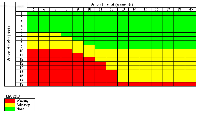
The danger presented to a vessel is a function of wave steepness as well as wave height and is unique to each vessel. For small vessels at a given wave height, the danger increases as the wave period decreases. Below is a table used as guidance within the National Weather Service to assist forecasters in identifying sea conditions which may require the issuance of a Small Craft Advisory. See FAQ 13 for definitions of a Small Craft Advisory.
The table was developed for coastal waters (within 60 nm of shore) off the Western US coast from Washington south to southern California and indicates potential danger to vessels with a closed cockpit configuration of ~100 feet or less. The specific values and conditions for the potential danger threats of the table cannot be applied to other waters such as the Gulf of America, Atlantic Ocean, Alaskan coastal waters or inland waters. However, an important message indicated by the table applies to all waters. That message is... for small vessels, danger increases when the wave period decreases (for a given wave height). The table is intended to be used as forecaster guidance only and not to directly correlate danger to a specific vessel. The danger presented by waves to your own vessel may be quite different.
16. Your marine forecast for my area was way off last weekend. What happened?
Weather forecasting is not a perfect science and conditions can change rapidly and unexpectedly. Always make certain you have the latest forecast and be aware of weather warnings via various dissemination methods. Most marine forecasts are updated every six hours and as conditions warrant.
Marine forecasting is made much more difficult than forecasting ashore due to a lack of available observations. Observations are required for NWS computer forecast models and by the forecaster to provide value-added decision making to the computer model output. Observations also serve to alert the forecaster when NWS forecasts do not agree the actual conditions and therefore, a problem exists in the current forecast process. Whereas 1000's of observations might be available for your local land forecast, only one or two observations might be available for the local marine forecast. NWS is continually working to expand its network of buoy and C-MAN stations, and volunteer observers.
The conditions in your location can be different than the general marine forecast due to local effects. For example, a strong land breeze might serve to flatten the waves immediately along the coast. A strong current, such as around a jetty or associated with the Gulf Stream, can increase wave heights.
If you are using a marine point forecast, the point you've selected may not be fully representative of the area in which you are operating. It is therefore recommended that mariners also view available text and graphic forecasts for the general area in which they are operating to maintain greater domain awareness. The point forecast pages each provide a link to the associated marine zone forecast which may be found in the upper left hand corner, as well as a link to NDFD graphics in the bottom left corner.
Be aware that wave forecasts are an average. The height of some individual waves can be expected to be as much as two times greater. Reports of "rogue" waves of even greater heights are not uncommon. See FAQ question #14.
17. I know marine observations are critical to your forecast process. How may I participate in one of your voluntary observing programs?
See Voluntary Marine Observation Programs
18. How do I convert knots(kt) to mph, etc?
Some common unit conversions for mariners:
1 knot(kt) = 1.15 mph = .51 meters/sec
1 nautical mile (nm)= 1.15 statute miles = 1852 meters
60 nautical mile (nm)= 1 degree latitude
1 millibar (mb) mercury = .02953 inches mercury
Fahrenheit = 1.8*(Celsius) + 32
1 fathom = 6 feet
Nautical Calculators courtesy of the NGA
19. What is the "1-2-3 Rule" used for hurricane avoidance?
The 1-2-3 Rule has been replaced by the Tropical Cyclone (TC) Danger graphic.
The National Hurricane Center and Central Pacific Hurricane Center prepare Atlantic, East Pacific and Central Pacific "Tropical Cyclone Danger Area" charts for broadcast via radiofax. See also: https://www.nhc.noaa.gov/tafb_latest/danger_atl_latestBW.gif
20. Why must some radio receivers be tuned 1.9 kHz lower than the assigned frequency to receive radiofax transmissions?
Radiofax is a means of transmitting black and white pictures by shifting the frequency of the transmitter. -400 Hz=black, 0Hz=grey, +400 Hz=white. The center of these radiofax transmissions is known as the assigned frequency.
In order for these transmissions to be received as tones for further processing, the radiofax receiver must be tuned to a lower "carrier" frequency, due to the manner in which radios operate. A convention of 1900 Hz (1.9 kHz) lower has been selected for the majority of radiofax receiving systems. The following will then be heard on the receiver: black=1500 Hz, grey=1900 Hz, white=2300 Hz. The receiver must also be operated in the Upper Sideband (USB) mode or the signal will be heard as dead air rather than as a tone.
To confuse the issue, many dedicated radiofax receivers allow the user to dial in the assigned frequency while the actual electronics is tuned to a carrier frequency 1.9 kHz lower. In general, dedicated radiofax receivers use assigned frequencies, while receivers or transceivers, connected to external recorders or PC's, are operated in the upper sideband (USB) mode using carrier frequencies.
21. Why does my radiofax reception appear to be so poor? Can't the Coast Guard increase the power?
Be certain you are listening on a frequency appropriate to your operating area and time of day and have tried all available frequencies. Propagation can change frequently.
In most instances, there's little that can be done as this is primarily related to where we are in relation to the 11 year sunspot cycle, and this is very bad cycle as well, which is all but wiping out long distance HF communication. If the Coast Guard were to double the power to 10KW, this would only bring about a 3db improvement on the receive side which would barely be noticeable, while greatly adding to the wear and tear on the Coast Guard's aging inventory of HF transmitters and putting the program at risk.
There are wide variations in user's equipment. In general you may get better reception using a modern specialized radiofax receiver, however, there is little that can be done with a truly weak signal due to poor propagation.
If you have e-mail capability, please check out our FTPMAIL system as a means of receiving radiofax charts, see FAQ #3
22. How can I send in a broadcast reception report from a US Coast Guard Station and request a QSL card from the US Coast Guard?
You can send an email with your reception report and request for a QSL card to the US Coast Guard's Central Communication Headquarters at:
23. Why don't you broadcast 500 MB radiofax charts from New Orleans or Honolulu like you do for the other radiofax stations? Where can I learn about using 500 MB charts?
500 MB charts are not made available for tropical areas via radiofax as they are of limited value in determining future trends according to our staff meteorologists forecasting for these areas, and therefore not produced with our limited resources.
Some computer-generated upper air charts are available at the following links:
To learn about using 500 MB charts, click HERE for a recent authoritative article published in the Mariner's Weather Log.
24. Where can I get a marine forecast for areas outside of the NWS' area of responsibility?
High Seas forecast zones are divided into 21 METAREAs covering the world's major waterways. For a map of these METAREAs, see this site: https://wwmiws.wmo.int/. There are 19 countries which are responsible for providing high seas forecasts and warnings for these 21 METAREAs. The U.S. is responsible for METAREAs IV and XII which cover large areas of the western Atlantic Ocean (IV) and eastern Pacific Ocean (XII).
When clicking on the appropriate METAREA at this website: http://www.gmdss.org/metareas.html, you can find links to high seas and offshore forecasts provided by the country responsible for that particular METAREA. You can also find links to more localized and coastal forecasts (such as NAVTEX forecasts) and links to marine websites from the respective country after clicking on a METAREA of interest.
These forecasts and warnings are broadcast via satellite. See our GMDSS (Global Maritime Distress and Safety System) section for more information.
The NWS National Digital Forecast Database contains marine forecast elements for the offshore and high seas as well.
Our Weather Charts on the NET section can help you find weather information outside the NWS' area of responsibility.
If you only have e-mail capability without direct Internet access, a webpage describing several different e-mail "robots" similar in concept to our FTPMAIL service, including some with advanced features such as allowing retrieval of NWS marine GRIB files,simple webpages, and allowing products to be retrieved on a scheduled, recurring basis may be found at: https://www.weather.gov/media/marine/robots.txt
For worldwide radiofax broadcast schedules worldwide visit:
The World Meteorological Organization (WMO) hosts a website with links to meteorological services across the world http://worldweather.wmo.int/en/home.html
Also try the Naval Oceanography Portal
25. Who can I talk to provide comment on my local NOAA Weather Radio broadcast or have some questions answered?
Write or call your local Weather Forecast Office
26. I've tried using your FTPMAIL system to retrieve forecasts via e-mail and it seems to work OK for text forecasts but I get back a bunch of gibberish starting with something like "begin 600 PWAE98.TIF" when I try to retrieve a graphic product. What's going on?
As referenced in the FTPMAIL "help" file, attachments are received in UUencoded form. The majority of modern e-mail systems handle the conversion automatically, other users will need to run a UUdecode program for their particular system. UUdecode freeware and shareware may be found on the Web, but the easier solution is to try a different e-mail system if that option is open to you.
27. Except on the Great Lakes, why do products cut off at the Canadian border?
There are many technical and legal ramifications to be addressed when trying to create a seamless suite of products with another country's Meteorological Agency. The NWS and Environment Canada work together to provide a seamless suite of marine products as much as possible. To provide comment, contact Environment Canada and the U.S.
28. How can I get a marine forecast by entering my Zip Code or the name of my City?
How can I get a marine forecast by entering my latitude and longitude?
Most NWS pages offer a link such as that immediately below which provide the capability of obtaining a forecast for a selected point on land by entering a zip code or the name of the city. However, as marine areas are not uniquely associated with zip codes or cities, marine forecasts are not directly available using this link. As a workaround, first enter a zip code or city/state to obtain a nearby land forecast, then Pan, Zoom, and Single-Click on the map labeled "Click Map for Forecast" to obtain the marine forecast for the point of interest.
|
||||
Marine point forecasts are not yet available and/or may only be available experimentally in the areas of Alaska, Micronesia, Samoa, offshore, high seas, Canada, etc.....(a zone forecast may be returned in some of these cases...a zone forecast may also be returned when point data is temporarily unavailable)
A latitude/longitude entry webform for obtaining marine point forecasts where NDFD data is available may be found on the marine point forecast page.
29. What is a "Marine Zone Forecast"? What is a "Marine Point Forecast"?
What is a "Marine Zone Forecast"?
National Weather Service marine zones are specific, defined over-water areas contained in the various NWS marine forecast products. Each zone is identified by a text description and a Universal Generic Code (UGC), e.g. LONG ISLAND SOUND EAST OF NEW HAVEN CT/PORT JEFFERSON NY, ANZ330. Zones are divided to identify meteorlogically dissimilar areas. Marine Zone Forecasts outline the range of conditions which may be found within the entire zone. The size of a zone and the number of zones within a forecast product is a compromise between forecast accuracy and dissemination limitations. Click HERE for several different options to obtain marine zone forecasts.
NOTE....High seas forecasts track individual weather systems rather than subdividing the forecast area into zones and providing a forecast for each.
What is a "Marine Point Forecast"?
A National Weather Service "Marine Point Forecast" refers a text forecast for a single point. In actuality, the "point" is a single small rectangle which represents the resolution of the computer forecast models which is typically 2.5 by 2.5 kilometers. The point forecast is generated from a forecaster-generated gridded data set known as the National Digital Forecast Database (NDFD) also used to produce graphics. The NDFD is used as the basis for the majority of local public and marine forecasts and is in the process of being further expanded to the offshore and high seas areas.
Please Note: Being a forecast for a single point, the point forecast is very specific and mariners should also be aware of weather conditions in the surrounding area. Forecast information for the surrounding area can be found within the zone forecast and the NDFD graphics. Be aware, the forecast conditions at a particular point may not exceed the criteria of a Small Craft Advisory, Gale, Storm etc. These watches/warnings/advisories are issued for the entire zone in which the point resides and mariners should act accordingly.
Marine Point Forecasts are available as part of National Weather Service webpages popularly known as the "Point-and Click" pages. Included on these pages are the Forecast-at-a-Glance feature which allows a quick overview of forecast weather, a listing of any active warnings, watches or advisories, and links to an "Hourly Weather Graph" and other data of local interest. Marine "Point-and Click" pages are available HERE and via the maps found at the relevant forecast office. At the majority of offices clicking on the map will link to the marine zone forecast and then allow further zooming to the point of interest whereas on the Great Lakes, the first link is directly to a point forecast with the further option to link to the associated zone forecast which includes that point.
Note....Point forecasts are not yet available and/or may only be available experimentally in the areas of Alaska, Micronesia, Samoa, offshore, high seas, Canada, etc.....(a zone forecast may be returned in some of these cases...a zone forecast may also be returned when point data is temporarily unavailable)
30. Do you have any mobile weather apps?
The National Weather Service has not developed and does not support any mobile apps for marine weather forecasts. Our approach has been to make our data readily available to developers in Internet standard formats, which allows third party developers who have the resources to develop and support the apps for a wide variety of platforms and operating systems. This approach has fostered development of a number of marine-relevant apps that use NWS and NOAA data, which you would need to investigate to determine which of these meet your actual requirements.
We do offer two bare-bones sites with limited functionality for those with "bandwidth-impaired" devices such as cellphones, smartphones, tablets, and PDA's:
31. Where can I get tsunami information?
Go to the U.S. Tsunami Warning System website or visit the National Tsunami Hazard Mitigation Program website. You can also visit your U.S. local Weather Forecast Office. Tsunami warnings are broadcast through local radio and television, marine radio, wireless emergency alerts, and NOAA Weather Radio. They may also come through outdoor sirens, local officials, text message alerts and telephone notifications.
32. Where can I get information about volcanic ashfall and its effects on marine navigation?
Here is a webpage with links to Volcanic Ash Advisory Centers around the world, including ones in Anchorage, AK and Washington DC. Learn more about how volcanic ash can affect marine navigation. Volcanic ash can have an impact on air quality as well.

