National Weather Service United States Department of Commerce

Fire Weather Concerns; Record Warmth Spreads

The Plains to the mid-Mississippi Valley continue with warm and dry conditions. Any fires that initiate could spread quickly. The warm temperatures will expand across the Southern Plains into the Southwest where numerous records are expected through the weekend. Meanwhile, a cold front will move southward across the northern Plains and Great Lakes region where some snow will develop this weekend. Read More >

 Today's Weather Impact Levels (click on specific hazard for details)
Lightning
Tornado
Wind
Hail
Flood
Heat/Cold
Visibility
Rip Current
Waves
 
Lightning

 
Tornado

 
Wind

 
Hail

 
Flooding

 
Heat/Cold

 
Visibility
 
 
Rip Current

 
Seas/Waves


Lightning_code  

Tornado_code  

Wind_code  

Hail_code  

Flood_code  

Temperature_code

Visibility_code

RipCurrent_code  

Wave_code  

 Wave Hazard
Wind Waves & Swell
Tsunamis
 Legend
None Significant wave height 6 feet or less.
Slight Significant wave height 7 to 9 feet possible.
Moderate Significant wave height 10 to 11 feet possible. Beach erosion possible.
High Significant wave height 12 feet or greater possible. Battering surf with major beach erosion possible.
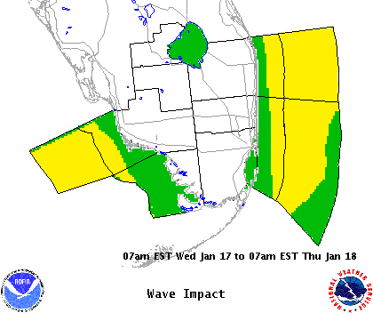
  Wave Impact Statement


For additional hazard information, view the full Hazardous Weather Outlook text. During a tropical cyclone situation, view the Hurricane Local Statement for additional hazard details.