 |
 |
|||||
The Storm of November 9-11, 1998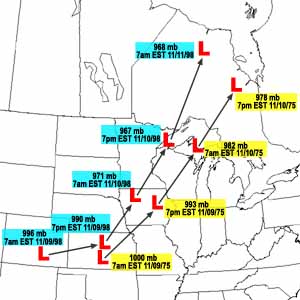
The track of the November 1998 storm (labeled in blue) was very similar to the track of the November 1975 storm (labeled in yellow). Image created by Don Rolfson, National Weather Service Marquette
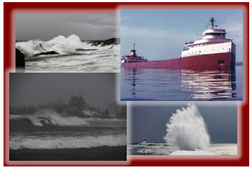
Track and measured pressure More recently and almost to the same hours and following practically the same track as the November 1975 storm, a more intense storm system tracked northeast from the central U.S. through the Great Lakes region during the period of November 9-11, 1998. On the morning of November 9, a low pressure system was organizing in eastern Colorado. Its pressure at that time was 29.41 inches (996mb). The system tracked east and then curved northeast, reaching northwest Iowa on the morning of November 10. It had rapidly intensified with its pressure dropping to 28.70 inches (971mb). The storm system further strengthened to an unusually low 28.55 inches (967mb) as it tracked just east of Duluth, MN early in the evening of the 10th. By the morning of November 11th, the low was located in north central Ontario. Its pressure at that time was 28.58 inches (968mb). Observations on Lake Superior The November 1998 storm produced widespread damaging winds across the upper Great Lakes region. On Lake Superior, the observing sites at Devils Island within Wisconsin's Apostle Islands, at Rock of Ages and at Passage Island on the south and north ends of Isle Royale, respectively, and at Stannard Rock, 40 miles north of Marquette, all reported lengthy periods of gale force winds of 34 to 47 knots. Gusts frequently exceeded 50 knots. Wind directions were primarily east, southeast, and south as the storm center approached and then moved over western Lake Superior. The wind then shifted west and northwest as the low moved into Ontario. While wave observations were not available, the long duration of gale and occasional storm force wind (wind in excess of 47 knots) likely produced significant wave heights of 20 to 25 feet on the open waters of Lake Superior. Again, keep in mind that the rare peak waves could have been one-and-a-half to two times that height. |
||||||
| Credits | Disclaimer | |
||||||

