
Dangerous heat will expand from the Gulf Coast into the Southern Plains and Desert Southwest through week's end. Additional extreme heat impacting the Pacific Northwest will shift to the northern Plains by the weekend. Tropical Storm Bertha is expected to continue to impact portions of the northwestern Gulf Coast from south central Louisiana to the upper Texas coast today. Read More >
Omaha/Valley, NE
Weather Forecast Office
48 Hour Snow Totals Ending 7 am 4/15/18
An early spring storm moved through the region April 13-14th and brought heavy snow to the area. 5 to 19 inches of snow fell in a wide swath from central Nebraska through South Dakota, northern Iowa, and Minnesota. Blizzard conditions were observed in many locations with winds gusting in excess of 50 mph. Numerous roads were closed for a time, and Interstate 80 was closed in portions of central and western Nebraska.
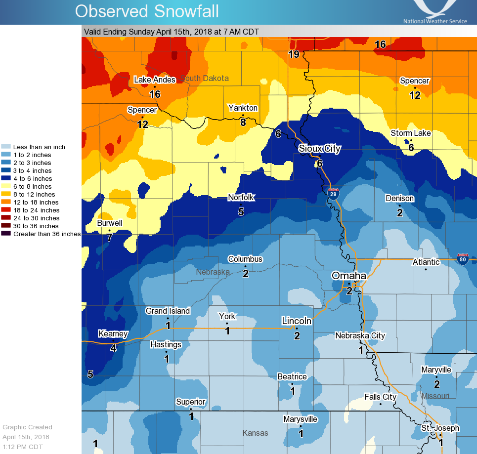
Here are some notable 2-day totals through 7 am 4/15/18
Neligh, NE 10"
Oakdale, NE 6.9"
Royal, NE 6"
Wayne, NE 6"
Bloomfield, NE 5.8"
Norfolk, NE 4-5"
Mondamin, IA 4"
Little Sioux IA, 3.4"
Omaha, NE Metro 2.5 - 3"
Lincoln, NE Metro 1.5 - 2"
NWS Valley 0.9"
Omaha Eppley, 0.6"
Warnings/Hazards
Forecast Discussion
Winter Weather
Severe Weather
Fire Weather
Drought
Storm Prediction Center
SubmitReport
Rivers And Lakes
River Forecasts
Missouri River Overview
Platte River Overview
Elkhorn River Overview
Ice Jam Risk
Local Information
Latest Briefing Packet
Weather Monitor
Winter Monitor
Preparedness
Storm Spotters
About Us
Other Useful Links
US Dept of Commerce
National Oceanic and Atmospheric Administration
National Weather Service
Omaha/Valley, NE
6707 North 288th Street
Valley, NE 68064-9443
402-359-5166
Comments? Questions? Please Contact Us.

