
A heat wave over the Southwest will intensify this week, peaking and expanding into the Intermountain West and northern High Plains this weekend. Critical to extremely critical fire weather conditions are forecast from the Northwest and the northern Great Basin this weekend. Particularly Dangerous Situation Red Flag Warnings have been issued. Read More >
Top Weather Events of 2021
Here is a look back at some of the top weather events that occurred in eastern Nebraska and southwest Iowa in 2021. Below the events are climate records and other facts from the year.
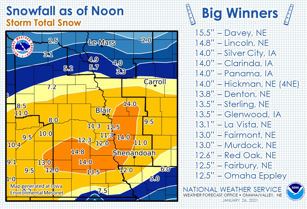
January 24-26, 2021 - Heavy Snowfall Covers Most of the Area
A long duration snowfall event began in the late night hours of January 24 and ended on the morning of January 26. A large area of 10+ inches of snow was observed with a peak amount of 15.5 inches falling at Davey, NE in northern Lancaster county. Omaha and Lincoln both set new daily snowfall records as they both observed snow for at least 24 consecutive hours. The entire area received plowable snow as NOHRSC analysis estimates 2-3 inches fell along the Nebraska/South Dakota border.
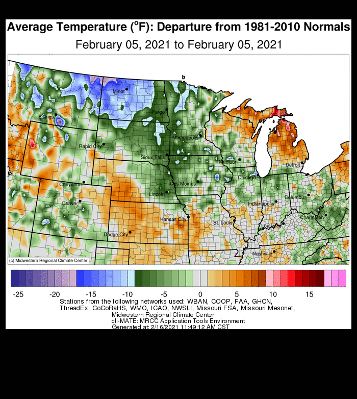
February 14-16, 2021 - Record Breaking Cold Air Outbreak
A southern migration of the polar vortex resulted in numerous broken temperature records and the first time rolling blackouts had been enacted in Nebraska. NCEP Real-Time Mesoscale Analysis (RTMA) estimated that all of eastern Nebraska and western Iowa remained below 0° for at least 48 hours, and many areas remained so for at least 72 hours. The temperature in Norfolk, Omaha, and Lincoln remained below 0° for 79, 63, and 61 hours respectively, the longest such streak since 1989. A total 7 new temperature records were between the 3 climate sites. A temperature of -42° was recorded at a COOP site near Fairbury. That was the 9th coldest temperature ever observed in Nebraska.
| Location | State | Type | Value | Date |
|---|---|---|---|---|
| Fairbury 5S | NE | COOP | -42° | 02/16/2021 |
| Albion | NE | COOP | -35° | 02/16/2021 |
| Mapleton No. 2 | NE | COOP | -35° | 02/16/2021 |
| Verdel 6SSE | NE | COOP | -34° | 02/15/2021 |
| Surprise | NE | COOP | -34° | 02/16/2021 |
| Tecumseh 1S | NE | COOP | -34° | 02/16/2021 |
| Elgin | NE | COOP | -33° | 02/16/2021 |
| Columbus | NE | AWOS | -32° | 02/16/2021 |
| Crofton | NE | COOP | -32° | 02/15/2021 |
| West Point | NE | COOP | -32° | 02/16/2021 |
| Auburn 5ESE | NE | COOP | -32° | 02/16/2021 |
| Springfield 7E | NE | COOP | -32° | 02/16/2021 |
| Syracuse | NE | COOP | -32° | 02/16/2021 |
| Oakdale | NE | COOP | -31° | 02/16/2021 |
| Norfolk Airport | NE | ASOS | -31° | 02/16/2021 |
| Hartington | NE | COOP | -31° | 02/16/2021 |
| Lincoln Airport | NE | ASOS | -31° | 02/16/2021 |
| Logan | IA | COOP | -31° | 02/15/2021 |
| Norfolk 4W | NE | COOP | -30° | 02/15/2021 |
| Little Sioux 2NW | IA | COOP | -30° | 02/16/2021 |
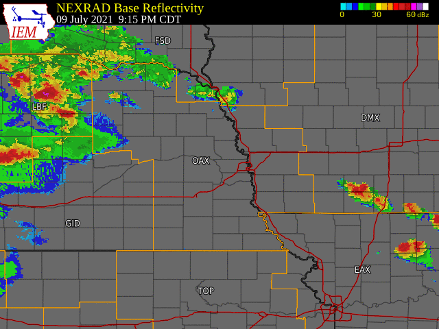
July 9, 2021 - Severe Storms and Damaging Wind
Discrete storm cells developed late in the evening and first produced damaging winds in Pierce and Madison counties and downed numerous trees and power lines. Power was knocked out for Battle Creek, NE. The peak wind gust measured at the Norfolk Airport was 63 mph at 11:05 pm. The discrete storm cells merged into a linear line ahead of a cold front and increased significantly in strength. The storm produced 70-80 mph winds to the north and west of Omaha. The line of storms surged through the city of Omaha and produced a 96 mph wind gust at Eppley Airfield. That tied the record for the strongest wind gust measured at the airport. OPPD reported that 188,000 customers were without power across the metro area, the most ever, topping the June 27, 2008 Omaha wind storm. A disaster declaration was made and early estimates indicated there was approximately $30 million in damage, mostly to electrical utilities. In addition to powerline damage, there was widespread tree damage across the city with the Elmwood Park area being hit particularly hard.
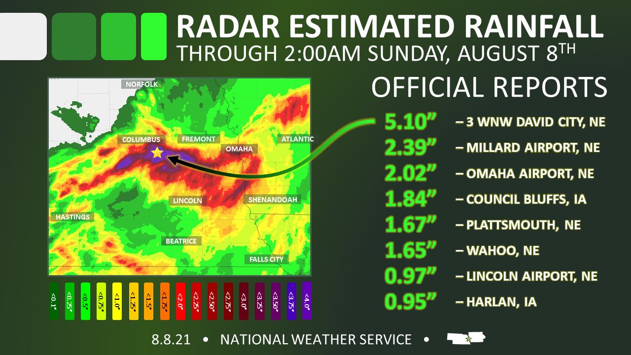
August 7, 2021 - Omaha Flash Floods
In the early evening hours, storms developed near Columbus and essentially followed the Platte River to the east and south. Estimates from radar put rainfall totals between 1 and 5 inches. Flash flood warnings were issued across central Eastern Nebraska and into Pottawattamie County including Council Bluffs. The worst damage occurred in Omaha where 2 to 3 inches of rain fell over about an hour. In some cases such as at Hanscom Park, 2 inches of rain was recorded in only 15 minutes. Flash flooding in the city washed through basement apartments, swept up cars, and heaved pavement in low-lying areas of the Omaha metro area. Numerous pictures and reports from social media showed city streets turning into raging rivers. The City of Omaha Public Works office estimates the damage to the city near $1.10M.
December 15, 2021 - Tornadoes, Derecho, Record Temperatures, Dust, Smoke, and Snow.
A low pressure system brought strong (both thunderstorm, and non-thunderstorm) winds, tornadoes, dust, snow, and record temperatures into eastern Nebraska and western Iowa. The event was determined to be a derecho meeting the criteria of wind damage extending more than 250 miles, including wind gusts of at least 58 mph and numerous gusts of at least 75 mph.
The event began with non-thunderstorm winds greater than 58 mph in southeast Nebraska and southwest Iowa. Falls City had a peak wind pre-storm wind of 62 mph around 2 pm.
Temperatures soared in the afternoon with many locations observing temperatures in the 70s, which is approximately 40° above normal. Shenandoah and Sidney both recorded a maximum temperature of 75°, the highest temperature ever recorded in the month of December for Iowa. Omaha, Lincoln, and Norfolk all set maximum temperature records, with Omaha and Lincoln both breaking the previous record by 10° or more. The stage had been set for the day as the normal diurnal pattern was interrupted with temperatures beginning to rise around 3 to 4 am, well before sunrise.
An influx of moisture contributed to the increased instability that would later help sustain the damaging derecho. Dew point temperatures in eastern Nebraska were observed in the upper 50s while in southwest Iowa they peaked at 64° at Harlan. The dew point temperatures were 30° warmer than climatic average for air temperature. The dew point temperature at Omaha reached 61° which would have matched the previous maximum air temperature record.
Storms developed in northern Kansas around 3 pm, and quickly arrived into the OAX service area as they were moving between 60 to 80 mph. The first thunderstorm warning in the area was issued at 4:16 PM. The line of storms produced 25 confirmed tornadoes (9 EF-2, 14 EF-1, and 2 EF-0). The strongest measured wind gust was 92 mph at the Lincoln Airport. By 5:30 pm, the line of storms had cleared the service area.
The passing of the derecho was not the end of the event. Strong winds behind the cold front were nearly as strong as the straight line winds from the storms. The peak post-frontal wind gust was 70 mph, nearly matching the 74 mph wind gust measured from the derecho. These winds persisted for several hours and carried dust from Kansas which reduced visibility to a couple of miles at a few locations. The wind also carried a smell of smoke from large grass fires in Kansas.
Finally, to cap off the event, measurable snow up to a 0.5 inch fell in the northwest portion of the OAX service area.
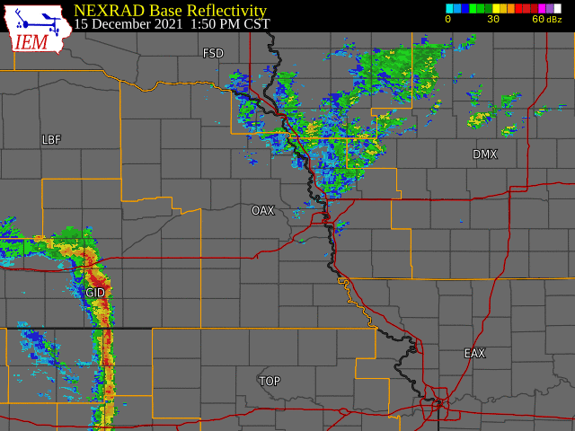
Radar loop from 2 PM to 5 PM
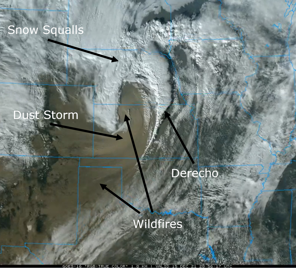
Annotated satellite imagery from Dec 15 at 5 PM
2021 Climate Extremes
(data from NWS Cooperative & CocCoRaHs/NeRAIN observers)
Hottest Temperatures
Coldest Temperatures
Highest Yearly Precipitation
Lowest Yearly Precipitation
Highest 24-Hour Rain Totals (From 7 am to 7 am ending on the specified date)
Highest 24-Snowfall Totals (From 7 am to 7 am ending on the specified date) (Only used highest total of closely located stations)
Highest Storm-Total Snowfall Totals (highest 1-2 day totals) (Only used highest total of closely located stations)
New (or Tied) Climate Records
|
Maximum Temperature |
||||
| Location | Date | New Record | Old Record | Year |
| Lincoln | June 17 | 103 | 101 | 1918 |
| Norfolk | June 17 | 100 | 100 | 1918 |
| Omaha | June 17 | 105 | 100 | 1918 |
| Lincoln | September 27 | 94 | 93 | 1956 |
| Omaha | September 27 | 93 | 92 | 1956 |
| Norfolk | September 28 | 93 | 90 | 1922 |
| Omaha | November 23 | 67 | 64 | 2006 |
| Norfolk | December 2 | 66 | 66 | 1919 |
| Lincoln | December 2 | 71 | 68 | 2012 |
| Omaha | December 2 | 68 | 67 | 1973 |
| Lincoln | December 15 | 74 | 64 | 1939 |
| Norfolk | December 15 | 67 | 64 | 2002 |
| Omaha | December 15 | 74 | 61 | 2002 |
| Lincoln | December 24 | 65 | 62 | 1889 |
| Norfolk | December 24 | 58 | 57 | 1922 |
|
Minimum Temperature |
||||
| Location | Date | New Record | Old Record | Year |
| Lincoln | February 15 | -26 | -11 | 1978 |
| Omaha | February 15 | -19 | -12 | 1979 |
| Lincoln | February 16 | -31 | -18 | 1978 |
| Norfolk | February 16 | -31 | -22 | 1936 |
| Omaha | February 16 | -23 | -17 | 1979 |
| Lincoln | April 1 | 17 | 17 | 1899 |
| Lincoln | April 22 | 23 | 25 | 1992 |
|
Low Maximum Temperature (Cold high temperatures) |
||||
| Location | Date | New Record | Old Record | Year |
| Lincoln | February 15 | -4 | -1 | 1936 |
| Omaha | February 15 | -3 | -1 | 1936 |
|
High Minimum Temperature (Warm low temperatures) |
||||
| Location | Date | New Record | Old Record | Year |
| Lincoln | March 9 | 48 | 47 | 1902 |
| Norfolk | March 9 | 46 | 37 | 1902 |
| Omaha | March 9 | 50 | 46 | 1902 |
| Norfolk | April 5 | 60 | 56 | 1921 |
| Norfolk | June 17 | 73 | 73 | 1939 |
| Omaha | June 17 | 80 | 79 | 2018 |
|
Maximum Precipitation |
||||
| Location | Date | New Record | Old Record | Year |
| Lincoln | January 25 | 1.13 | 0.48 | 1941 |
| Norfolk | January 25 | 0.44 | 0.4 | 1902 |
| Omaha | January 25 | 0.91 | 0.52 | 1941 |
| Lincoln | March 13 | 0.79 | 0.68 | 1990 |
| Lincoln | March 14 | 2.97 | 0.86 | 1913 |
| Norfolk | March 14 | 2.74 | 1.14 | 1913 |
| Omaha | March 24 | 1.03 | 0.99 | 1973 |
| Lincoln | April 8 | 0.86 | 0.85 | 1922 |
| Norfolk | August 31 | 1.34 | 1.34 | 2014 |
| Lincoln | October 24 | 1.5 | 0.85 | 1997 |
| Norfolk | October 28 | 1.32 | 0.81 | 1901 |
| Omaha | October 28 | 2.28 | 1.6 | 1997 |
|
Maximum Snowfall |
||||
| Location | Date | New Record | Old Record | Year |
| Lincoln | January 25 | 14.5 | 6.1 | 1991 |
| Norfolk | January 25 | 6.6 | 5.1 | 1950 |
| Omaha | January 25 | 11.9 | 7.1 | 1941 |
| Lincoln | February 6 | 5.5 | 2.2 | 2005 |
| Norfolk | February 6 | 2.3 | 1.2 | 1978 |
| Lincoln | February 7 | 4.1 | 2.3 | 1997 |

