
Dangerous and extreme heat will remain across portions of the southern U.S. this week. Heavy rainfall may bring significant flash flooding across portions of the Mid-Atlantic and Northeast through the night, and additional flash flooding concerns across New England on Wednesday. Monsoonal thunderstorms will bring a flash flood risk to the Four Corners region, especially in burn scar areas Read More >
Overview
|
A cluster of supercell thunderstorms moved through the region during the evening of Tuesday, June 14 2022 into the early morning hours of Wednesday, June 15th 2022. The storms produced widespread wind gusts of 75 to 115 mph, hail up 1 to 3 inches in diameter, and two EF1 tornadoes. Minor flooding was also reported in Omaha. The storms caused widespread tree damage, and some structural damage to homes and businesses. |
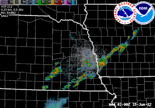 Radar loop from 6/14/2022 9 pm through 6/15/2022 2 am |
Tornadoes:
|
Tornado - 2 NNW Murdock, NE
Track Map 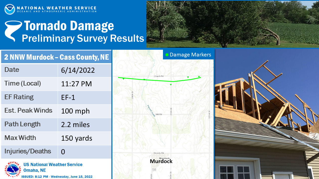  |
||||||||||||||||
|
3 S Treynor, IA
Track Map 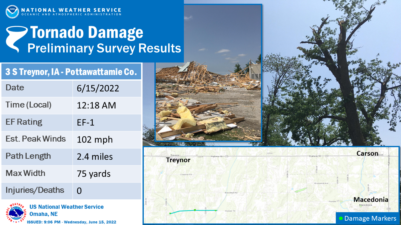
|
||||||||||||||||
The Enhanced Fujita (EF) Scale classifies tornadoes into the following categories:
| EF0 Weak 65-85 mph |
EF1 Moderate 86-110 mph |
EF2 Significant 111-135 mph |
EF3 Severe 136-165 mph |
EF4 Extreme 166-200 mph |
EF5 Catastrophic 200+ mph |
 |
|||||
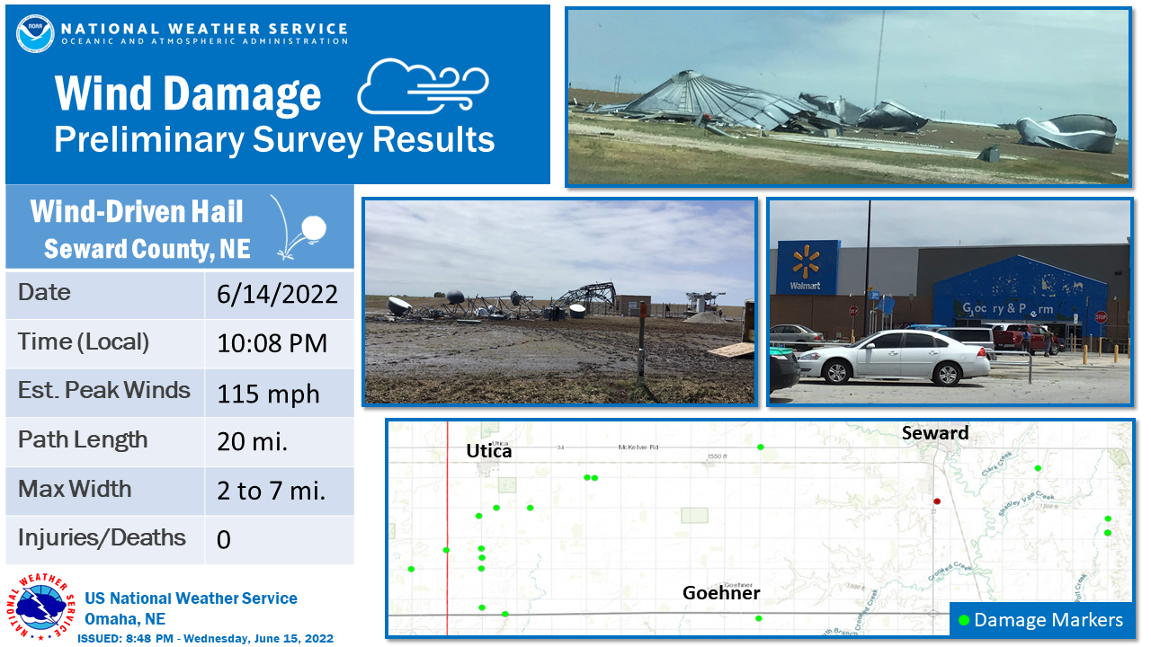
Wind & Hail:
Supercell storms produced damaging winds 75 to 115 mph and also produced wind driven hail 1 to 3 inches in diameter. Some of the more notable damage is shown below.
 |
 |
Storm Reports
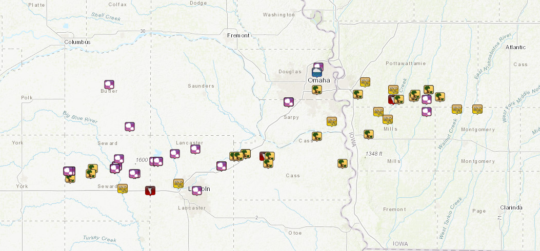 |
..TIME... ...EVENT... ...CITY LOCATION... ...LAT.LON...
..DATE... ....MAG.... ..COUNTY LOCATION..ST.. ...SOURCE....
..REMARKS..
1008 PM Tstm Wnd Dmg 2 S Utica 40.87N 97.34W
06/14/2022 Seward NE NWS Storm Survey
NWS damage survey confirmed that an
extensive area of intense winds, often
accompanied by significant hail, impacted a
large portion of Seward county. Damage
suggests that the peak wind approached 115
mph at times 2 miles south of Utica, with
several damage indicators indicating wind
speeds greater than 100 mph. Dozens of
center pivot irrigation systems were
completely flipped over. A cell phone tower
collapsed. Barns were badly damaged or
destroyed. The wind driven hail, at times up
to 3 inches in diameter according to
residents, completely destroyed crops to the
extent that some fields appeared to have
never had crops planted in them despite
being full and green prior to the storm.
Numerous homes experienced windows and
siding completely destroyed. In several
places, trees were debarked due to the wind
driven hail. The hardest hit area was in a 2
to 7 mile wide (north to south) area
extending from the York county line through
5 miles east of Seward and running along and
south of Highway 34.
1008 PM Hail Utica 40.90N 97.35W
06/14/2022 M1.75 inch Seward NE Public
Home with several windows broken.
1008 PM Tstm Wnd Gst Utica 40.90N 97.34W
06/14/2022 E50 MPH Seward NE Public
1011 PM Tstm Wnd Dmg 1 N Tamora 40.91N 97.22W
06/14/2022 Seward NE Public
Delayed report. Overturned irrigation pivot.
1014 PM Hail Utica 40.90N 97.34W
06/14/2022 M1.50 inch Seward NE CO-OP Observer
Ping pong ball sized hail.
1018 PM Hail Utica 40.90N 97.34W
06/14/2022 M1.00 inch Seward NE Public
quarter sized hail.
1027 PM Hail 4 S Garland 40.89N 96.99W
06/14/2022 E3.00 inch Seward NE Public
Delayed report. Time estimated via radar.
Widespread hail damage to home. Broken back
window on automobile.
1028 PM Hail 1 NE Seward 40.92N 97.09W
06/14/2022 M1.25 inch Seward NE Cocorahs
1029 PM Hail Seward 40.92N 97.09W
06/14/2022 E1.00 inch Seward NE Public
Report from mPING: Quarter (1.00 in.).
1029 PM Hail Seward 40.92N 97.09W
06/14/2022 E2.00 inch Seward NE Public
Report from mPING: Hen Egg (2.00 in.).
1030 PM Hail Seward 40.91N 97.10W
06/14/2022 M2.25 inch Seward NE Broadcast Media
2.00-2.25 inch hail at Seward Super Carwash.
1030 PM Tstm Wnd Gst 4 N Milford 40.83N 97.06W
06/14/2022 E61 MPH Seward NE Public
Personal Weather Station.
1030 PM Hail Seward 40.91N 97.10W
06/14/2022 M2.00 inch Seward NE Public
Hail as big as 2.25 inches.
1030 PM Hail 3 NNE Seward 40.95N 97.08W
06/14/2022 E1.25 inch Seward NE Public
1030 PM Hail Seward 40.91N 97.10W
06/14/2022 M1.75 inch Seward NE Trained Spotter
1030 PM Hail Seward 40.91N 97.10W
06/14/2022 E1.75 inch Seward NE Trained Spotter
1035 PM Hail 4 SSW Garland 40.89N 97.00W
06/14/2022 M1.50 inch Seward NE Public
Broken skylight and windows.
1250 AM Hail Utica 40.90N 97.35W
06/15/2022 E1.00 inch Seward NE Public
1255 AM Tstm Wnd Dmg Tamora 40.89N 97.23W
06/15/2022 Seward NE Public
Power lines blown down. Power out.
1148 PM Hail 2 W Chalco 41.18N 96.17W
06/14/2022 E1.00 inch Sarpy NE Public
Corrects previous hail report from 2 W
Chalco. Report from mPING: Quarter (1.00
in.).
1155 PM Hail 2 W Chalco 41.18N 96.17W
06/14/2022 M1.00 inch Sarpy NE Public
1157 PM Tstm Wnd Gst 1 WSW Offutt Afb 41.10N 95.94W
06/14/2022 E75 MPH Sarpy NE Public
1044 PM Tornado 2 NE Pleasant Dale 40.82N 96.91W
06/14/2022 Lancaster NE Law Enforcement
Reports of debris near the pleasant dale
exit on I-80.
1048 PM Hail 3 NNW Malcolm 40.94N 96.89W
06/14/2022 E2.00 inch Lancaster NE Emergency Mngr
1055 PM Tstm Wnd Gst 4 WNW Lincoln 40.85N 96.76W
06/14/2022 M59 MPH Lancaster NE ASOS
1057 PM Hail 2 N Malcolm 40.94N 96.87W
06/14/2022 M3.00 inch Lancaster NE Amateur Radio
Corrects previous hail report from 2 N
Malcolm. Ping pong ball size hail covered
the ground. A few stones as big as 3.5
inches. Substantial damage to trees, crops,
and vehicles.
1058 PM Hail 2 E Lincoln 40.82N 96.66W
06/14/2022 E1.00 inch Lancaster NE Public
Report from mPING: Quarter (1.00 in.).
1100 PM Hail 1 N Raymond 40.97N 96.78W
06/14/2022 E1.75 inch Lancaster NE Amateur Radio
1110 PM Hail Davey 40.99N 96.67W
06/14/2022 E1.00 inch Lancaster NE Public
1112 PM Tstm Wnd Dmg Waverly 40.92N 96.53W
06/14/2022 Lancaster NE Trained Spotter
Tree blown down into a fence. Winds
estimated at 70 mph.
1121 PM Hail Waverly 40.92N 96.53W
06/14/2022 E1.00 inch Lancaster NE Emergency Mngr
1121 PM Tstm Wnd Gst Waverly 40.92N 96.53W
06/14/2022 M61 MPH Lancaster NE Emergency Mngr
1255 AM Hail Creighton 42.47N 97.91W
06/15/2022 E1.25 inch Knox NE Public
0750 PM Hail 2 S Beatrice 40.25N 96.75W
06/14/2022 E0.75 inch Gage NE Public
Report from mPING.
1154 PM Tstm Wnd Dmg 2 NNE Ralston 41.23N 96.02W
06/14/2022 Douglas NE Public
Report from mPING: 1-inch tree limbs broken;
Shingles blown off.
1247 AM Hail 4 N Omaha 41.32N 96.01W
06/15/2022 E0.75 inch Douglas NE Trained Spotter
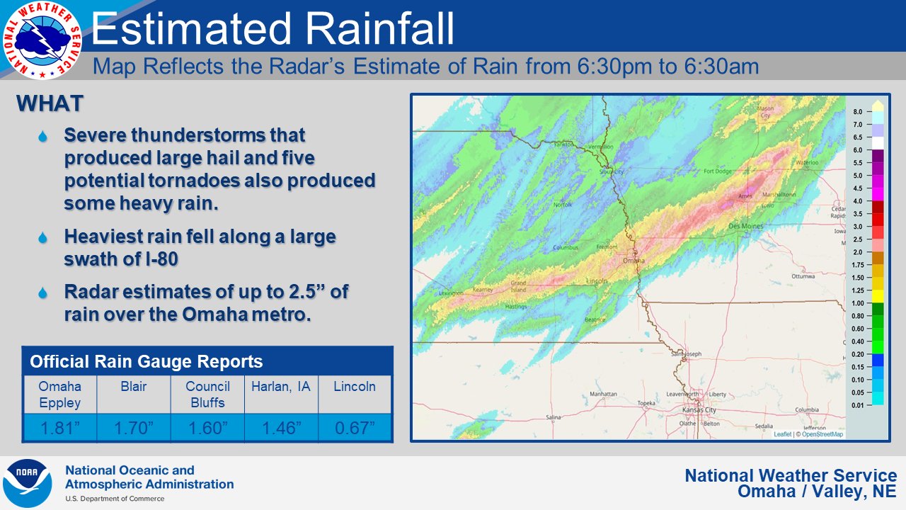
1052 AM Heavy Rain 2 N Omaha 41.30N 96.02W
06/15/2022 M2.88 inch Douglas NE Public
24 hour total.
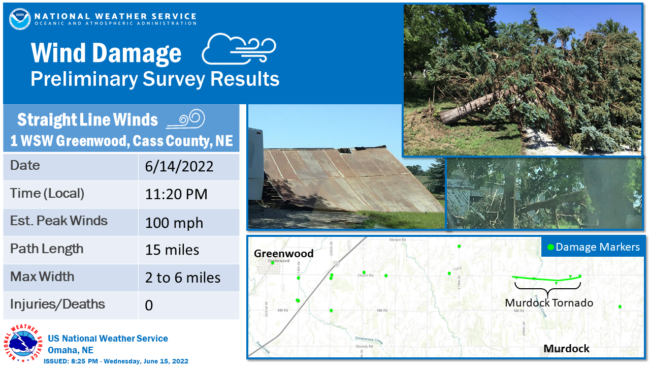
1120 PM Tstm Wnd Dmg 1 WSW Greenwood 40.96N 96.46W
06/14/2022 Cass NE NWS Storm Survey
An NWS survey team observed a broad, intense
area of severe straight line winds. Some of
the most intense winds extended from an area
near Greenwood to the east and southeast,
impacting Murdock, Louisville, Manley, and
other areas. Most of the damage was snapped
trees and power poles, but there was also
damage to buildings and grain bins. This
large downburst area was several miles wide
and frequently had 60 to 80 mph winds with
some locations experiencing gusts to nearly
100 mph. There was also a 2.2 mile long
tornado track within the severe wind area,
but aside from that track the vast majority
of damage was from a west to east or
northwest to southeast direction.
1127 PM Tornado 2 NNW Murdock 40.96N 96.30W
06/14/2022 Cass NE NWS Storm Survey
A tornado developed near Church Road west of
298th Street and immediately damaged a home.
One of the roof peaks was torn off and
garage doors blown in. The damage here was
very focused as nearby trees were not
damaged, but insulation from the home was
stuck to 3 different sides of the home,
indicating this was likely a tornado.
Farther east, there was an area of focused
tree damage approximately 150 yards wide
embedded within a several mile wide area of
more minor tree damage. The tornado
continued east where it snapped several
power poles and caused minor damage to a
church. Additional damage to grain bins and
trees was noted along Church road just west
of 322nd street, which appears to be the end
of the focused damage most likely caused by
the tornado. The tornado peak wind was
estimated at 100 mph with a path length of
2.2 miles and a maximum width of 150 yards.
This tornado occurred within a several mile
wide area of intense straight-line wind
damage which was caused by winds at times
greater than 80 mph.
1129 PM Tstm Wnd Dmg 2 N Murdock 40.96N 96.27W
06/14/2022 Cass NE Emergency Mngr
Delayed report: Two destroyed grain bins and
house damage. Time estimated by radar.
1130 PM Tstm Wnd Dmg Murdock 40.93N 96.28W
06/14/2022 Cass NE Amateur Radio
Multiple trees and power lines down.
1135 PM Tstm Wnd Dmg 2 ENE Greenwood 40.97N 96.40W
06/14/2022 Cass NE Emergency Mngr
*** 1 INJ ***
Corrects previous tstm wnd dmg report from 2
ENE Greenwood. Campers flipped over at
Campground. 1 possible injury from someone
trapped in a popup camper.
1138 PM Tstm Wnd Dmg 2 ENE Greenwood 40.97N 96.40W
06/14/2022 Cass NE Emergency Mngr
Substantial damage at the Pine Grove
campground.
1145 PM Tstm Wnd Dmg Greenwood 40.96N 96.44W
06/14/2022 Cass NE Emergency Mngr
Very large trees down.
1155 PM Tstm Wnd Dmg 4 E Cedar Creek 41.04N 96.02W
06/14/2022 Cass NE Public
Report from mPING: 3-inch tree limbs broken;
Power poles broken.
1155 PM Tstm Wnd Dmg 3 ENE Murray 40.93N 95.88W
06/14/2022 Cass NE Public
Report from mPING: 1-inch tree limbs broken;
Shingles blown off.
0120 AM Hail Dwight 41.08N 97.02W
06/15/2022 E1.00 inch Butler NE Law Enforcement
0325 AM Hail David City 41.25N 97.13W
06/15/2022 E1.75 inch Butler NE Law Enforcement
1216 AM Tstm Wnd Gst 5 ENE Council Bluffs 41.26N 95.76W
06/15/2022 M75 MPH Pottawattamie IA AWOS
1218 AM Tornado 3 S Treynor 41.19N 95.61W
06/15/2022 Pottawattamie IA NWS Storm Survey
Intermittent tornado began approximately 3
south of Treynor and ended 3 southeast of
Treynor. The tornado traveled mainly across
crop and pastureland. It struck a winery,
destroying the event center. Peripheral
damage to trees and vines.
1220 AM Tstm Wnd Dmg 4 ESE Council Bluffs 41.21N 95.80W
06/15/2022 Pottawattamie IA Public
Report from mPING: 1-inch tree limbs broken;
Shingles blown off.
1220 AM Tstm Wnd Gst Treynor 41.23N 95.61W
06/15/2022 E60 MPH Pottawattamie IA Public
1225 AM Tstm Wnd Dmg 3 SSE Treynor 41.19N 95.58W
06/15/2022 Pottawattamie IA Emergency Mngr
8 to 10 large trees snapped. Significant
damage to a home and outbuilding. Time
estimated based on radar.
1225 AM Tstm Wnd Dmg 4 WNW Macedonia 41.20N 95.50W
06/15/2022 Pottawattamie IA Trained Spotter
6 inch tree limb blown down, blocking road.
1227 AM Tstm Wnd Dmg 4 WNW Macedonia 41.21N 95.49W
06/15/2022 Pottawattamie IA Public
Substantial damage to a farmstead. Grain
bins destroyed. Other buildings blown off
foundation.
1230 AM Tstm Wnd Dmg Carson 41.23N 95.42W
06/15/2022 Pottawattamie IA Emergency Mngr
1 inch trees snapped.
1235 AM Hail Macedonia 41.19N 95.43W
06/15/2022 E1.00 inch Pottawattamie IA Public
From Facebook.
1235 AM Tstm Wnd Dmg 3 E Macedonia 41.20N 95.36W
06/15/2022 Pottawattamie IA Public
Large trees down in the Wheeler Grove
township.
1240 AM Tstm Wnd Dmg Carson 41.23N 95.42W
06/15/2022 Pottawattamie IA Emergency Mngr
Power lines down. Power out in town.
Structural damage to one business. Debris in
streets.
1240 AM Tstm Wnd Gst 6 W Elliott 41.15N 95.27W
06/15/2022 E70 MPH Montgomery IA Emergency Mngr
1246 AM Tstm Wnd Gst Elliott 41.15N 95.16W
06/15/2022 E70 MPH Montgomery IA Emergency Mngr
0920 PM Hail Henderson 41.14N 95.43W
06/14/2022 E1.25 inch Mills IA Public
Relayed via broadcast media. Picture of hail
larger than a quarter. Time estimated from
radar.
1210 AM Tstm Wnd Gst 4 NW Silver City 41.14N 95.69W
06/15/2022 M65 MPH Mills IA Public
1212 AM Tstm Wnd Dmg Glenwood 41.05N 95.74W
06/15/2022 Mills IA Public
Power lines down. Power out in Glenwood.
1218 AM Tstm Wnd Gst Silver City 41.11N 95.64W
06/15/2022 E90 MPH Mills IA Public
Rain Reports
 |
 |
Media use of NWS Web News Stories is encouraged! Please acknowledge the NWS as the source of any news information accessed from this site. |
|

